The Rural Technology Initiative ceased operations in 2011. This site is maintained as an archive of works from RTI collaborators from 2000 to 2011 and is no longer updated. RTI's successor and remaining staff can be found at NRSIG.org


Search the RTI Website
 
Click to go to the Precision Forestry Cooperative website
Click to go to the RTI Home page
Click to go to the About RTI page
Click to go to the RTI Projects page
Click to go to the RTI Publications page
Click to go to the RTI Tools page
Click to go to the RTI Geographic Information Systems page
Click to go to the RTI Streaming Video Directory
Click to go to the RTI Training page
Click to go to the RTI Contacts page
Click to go to the RTI Image Archive
Click to go to the RTI Site Map
Click to go to the RTI Links page


Results

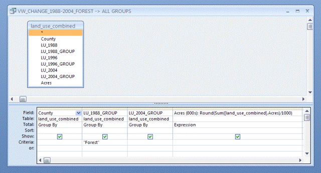
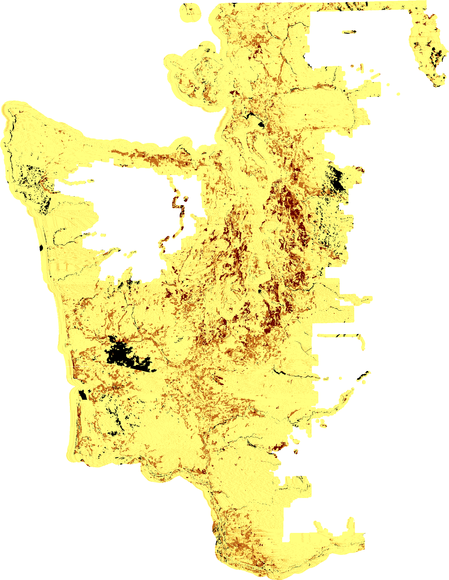
PROJECT HOME | BACKGROUND | METHODOLOGY | RESULTS AND DATA | REFERENCES

Some Caveats

Since the data is still being reviewed and has not undergone a strict peer-review process, this information should only be used as a reference, and not absolute fact.

As with any land use change analysis, much of the results are completely dependent on how the land use categories were defined. Without understanding how each land use group was defined, and arrived at, the data risks serious misinterpretation.

Thus, please read through the provided background and methodology (or contact us!) before using and/or interpreting any of the summary numbers provided in this section or the available data..

A few key points to consider and remember:

1. The smallest area mapped in this project was 10 acres

2. Classification consistency was tested, and received a high level of accuracy; however, classification accuracy was only tested on a minimal number of points and a relatively small area.

3. Please use at your own discretion.

4. If you are going to download the data, please read through the metadata.

5. The data includes a buffer into federal lands and water; for any queries or summary statistics, you will need to exclude all areas outside of the study area.

Please contact us with any questions, suggestions, and/or comments. We would like to continue to ensure that this data is as accurate as possible. If you discover any errors, please be in touch.

Example of using data

Let's say that we wanted to know the sum of all areas (in thousands of acres) that were classified in one of the three forest-related land uses in 1988 and what general land uses (forest, agriculture/mixed rural, developed) those areas were classified in 2004, by county.

Using the table provided in the data section below [Table], we could write and run the following query in SQL:

SELECT [Table].County, [Table].LU_1988_GROUP, [Table].LU_2004_GROUP, Round(Sum([Table].[Acres])/1000) AS [Acres (000s)]
FROM [Table]
GROUP BY [Table].County, [Table].LU_1988_GROUP, [Table].LU_2004_GROUP
HAVING ((([Table].LU_1988_GROUP)="Forest"));

Or, if we preferred to use the graphical user interface in Microsoft Access, we could design a query to look like the one below (click on the graphic to display a larger version of the query in a new window).

Once we ran the query, we would produce the following table:

Western Washington Counties
Generalized Land Use Group
Acres Changed
1988 2004
(000s)
Clallam Forest Forest 510
Clallam Forest Agriculture 41
Clallam Forest Built 8
Clallam Forest Water 2
Clallam Forest Unknown 12
       
Clark Forest Forest 224
Clark Forest Agriculture 14
Clark Forest Built 7
Clark Forest Water 1
       
Cowlitz Forest Forest 600
Cowlitz Forest Agriculture 18
Cowlitz Forest Built 10
Cowlitz Forest Water 5
       
Grays Harbor Forest Forest 818
Grays Harbor Forest Agriculture 98
Grays Harbor Forest Built 13
Grays Harbor Forest Water 8
Grays Harbor Forest Unknown 82
       
Island Forest Forest 62
Island Forest Agriculture 16
Island Forest Built 6
Island Forest Water 0
Island Forest Unknown 0
       
Jefferson Forest Forest 398
Jefferson Forest Agriculture 22
Jefferson Forest Built 6
Jefferson Forest Water 4
Jefferson Forest Unknown 8
       
King Forest Forest 414
King Forest Agriculture 38
King Forest Built 90
King Forest Water 6
King Forest Unknown 15
       
Kitsap Forest Forest 150
Kitsap Forest Agriculture 22
Kitsap Forest Built 48
Kitsap Forest Water 0
Kitsap Forest Unknown 0
       
Lewis Forest Forest 803
Lewis Forest Agriculture 103
Lewis Forest Built 8
Lewis Forest Water 7
Lewis Forest Unknown 1
       
Mason Forest Forest 354
Mason Forest Agriculture 43
Mason Forest Built 29
Mason Forest Water 1
Mason Forest Unknown 0
       
Pacific Forest Forest 434
Pacific Forest Agriculture 73
Pacific Forest Built 5
Pacific Forest Water 3
Pacific Forest Unknown 4
       
Pierce Forest Forest 421
Pierce Forest Agriculture 69
Pierce Forest Built 72
Pierce Forest Water 3
Pierce Forest Unknown 0
       
San Juan Forest Forest 73
San Juan Forest Agriculture 19
San Juan Forest Built 1
San Juan Forest Water 1
San Juan Forest Unknown 1
       
Skagit Forest Forest 444
Skagit Forest Agriculture 31
Skagit Forest Built 7
Skagit Forest Water 6
Skagit Forest Unknown 0
       
Skamania Forest Forest 221
Skamania Forest Agriculture 1
Skamania Forest Built 1
Skamania Forest Water 2
Skamania Forest Unknown 0
       
Snohomish Forest Forest 363
Snohomish Forest Agriculture 74
Snohomish Forest Built 52
Snohomish Forest Water 1
Snohomish Forest Unknown 30
       
Thurston Forest Forest 256
Thurston Forest Agriculture 66
Thurston Forest Built 27
Thurston Forest Water 1
Thurston Forest Unknown 1
       
Wahkiakum Forest Forest 127
Wahkiakum Forest Agriculture 13
Wahkiakum Forest Built 0
Wahkiakum Forest Water 1
       
Whatcom Forest Forest 398
Whatcom Forest Agriculture 35
Whatcom Forest Built 11
Whatcom Forest Water 10
Whatcom Forest Unknown 0

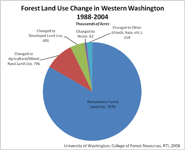
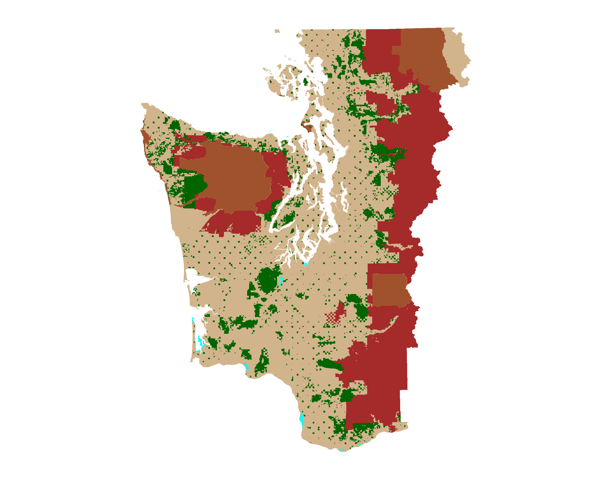
And, we could total the areas that remained in forest land use and the areas that changed to other land uses. As the table below shows, using the land use data from this project, we estimate that approximately 8,483,000 acres of non-federal land in western Washington were in forest land use in 1988; in 2004, 7,070,000 acres remained in forest land, while 796,000 acres changed to agricultural/mixed rural land uses, and 401,000 changed to more developed land uses. The remaining area (62,000 + 154,000) were classified as changing to water or other unclassified uses (clouds, haze, etc.).

Remained in Forest Land Use 7070
Changed to Agricultural/Mixed Rural Land Use 796
Changed to Developed Land Use 401
Changed to Water 62
Changed to Other (clouds, haze, etc.) 154
Total 8483

And, we might even be able to make a simple pie-chart.

Data

Four datasets were produced for this project: one land use dataset for each of the 1988, 1996 and 2004 study periods, and a land use change dataset that quantifies the change over the same period. We are also providing a text file to facilitate data summaries that is the combined data from all three datasets for those that do not have access to a GIS. More information, as well as direct links to download the data, is provided in the table below.

Western Washington Land Use Change Data Products
Dataset Name Browse Graphic Metadata Download
Western WA Land Use 1988
Click for a larger image
Western WA Land Use 1996
Click for a larger image
Western WA Land Use 2004
Click for a larger image
Western WA Land Use Change 1988, 1996, 2004
Click for a larger image
Tabular data for generating summary information   land_use_combined.txt

Western Washington Land Use Change Ancillary Data
Dataset Name Browse Graphic Metadata Download
Western WA Counties
Click for a larger image
Western WA Waterbodies
Click for a larger image
Western WA Public Lands
Click for a larger image
 
School of Environmental and Forest Sciences
USDA Forest Service State & Private Forestry
WSU Cooperative Extension
The Rural Technology Home Page is provided by the College of Forest Resources. For more information, please contact the Rural Technology Initiative, University of Washington Box 352100 Seattle, WA 98195, (206) 543-0827. © 2000-2004, University of Washington, Rural Technology Initiative, including all photographs and images unless otherwise noted. To view the www.ruraltech.org privacy policy, click here.
Last Updated 10/13/2022 12:34:21 PM