|
 |
 |
 |


Background
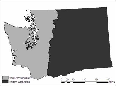
PROJECT HOME | BACKGROUND | METHODOLOGY | RESULTS AND DATA | REFERENCESBackground IntroductionThe USDA Forest Service’s Forest Inventory Analysis (FIA) program routinely monitors and measures the nation’s forest characteristics; the program is self-described as the “nation’s forest census.” As part of this monitoring, the program investigates and reports on the changing nature of land use patterns, especially how these land use patterns relate to change in forest cover and forest-related land uses. The Pacific Northwest’s FIA program recently produced a series of publications and findings related to land use change in western and eastern Oregon (Azuma et al. 1999). Using aerial photographs at a selected number of Oregon’s FIA points (the FIA has a permanent 3.4-mile grid system throughout the entire United States), a large number of people followed a fairly complicated procedure to interpret land use from the photo points; for western Oregon, approximately 24,000 photo points were analyzed for four different time periods: 1973, 1982, 1994 and 2000. The results of this massive aerial photo interpretation project were impressive. Land use planners and policy makers are currently relying on this information to help shape policy and zoning changes in Oregon. While the Oregon study was successful, it was costly and time-consuming. Additionally, the methods used in aerial photointerpretation are often interpreter-biased, meaning that different interpreters may decide on different land uses for the same photo point. Additionally, using satellite images for a land use classification poses many challenges; however, the size of western Washington (approximately 16 million acres) is far too large to use aerial photographs for a seamless land use classification.
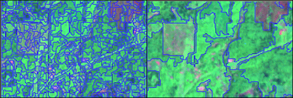
Study Area: Western Washington Western Washington Land UseThe population of western Washington has rapidly increased in the last 25 years, resulting in expanded urban areas and fragmentation of forested and agricultural lands. Human alterations of the land, such as more expansive road systems and the building of residential homes in previously undeveloped lands, can alter the biogeochemistry (Dwivedi et al. 2005), as well as wildlife habitat, water infiltration rates, and more. The increase of land in the wildland urban interface (WUI) as a result of urban expansion has implications for the economic viability of forestland to be managed for timber production and the ecological sustainability of these same lands for habitat and the production of natural resource amenities (Lambin et al. 2001, Wilson et al. 2003). In Washington, increased demand for housing near urban centers has increased the value of forest land, often making development more financially appealing than managing for timber, wildlife, or other ecological values. Research suggests that forests are managed less for timber production as urban developments grow around them (Barlow et al. 1998). Prices of land in urbanizing areas often receive more money per acre than other uses, such as timber or agricultural production, because of the increased personal income levels in cities and land development pressures (Alig and Healy 1987, Plantinga et al. 1990, Barlow et al. 1998). This decrease in timber production, and in some cases the subsequent conversion to non-forest land uses, could lead to economic and ecological problems for the county, state, or region where the land is located. The US Forest Service has recognized that the spatial and temporal quantification of patterns of land cover and land use change is important to their agency and the public, as well as forest land owners, managers, and policy makers. Remote Sensing and Land UseRemote sensing is the detection of aspects of the landscape using sensors, not in contact with the landscape, that can measure characteristics of the landscape's surface. The data collected during remote sensing can be in many forms, such as acoustical waves, physical forces, and electromagnetic energy. Visible light is only a portion of the electromagnetic energy spectrum, which also includes ultraviolet and infrared. The data received from the sensors may include temperature, surface reflectance, topography, and more. This raw day must be analyzed before further information can be inferred about landscape patterns and processes. Remote sensing has been used in a number of applications, including but not limited to determining the drivers of land use change (Lo and Yang 2002, Yang and Lo 2002), damage estimation after earthquakes (Bitelli et al. 2004), mapping fires (Gitas et al. 2004, Zhang et al. 2005), identifying areas to target for non-point pollution management (Harris and Ventura 1995), relating geography with socio-economic factors (Seto et al. 2002), and designating areas for capital improvements (Jensen et al. 1994). The FIA program traditionally employed aerial photointerpretation analysis methods for land use change detections (Campbell 1983, Lindgren 1985, Lindhult et al. 1988, Luloff and Befort 1989, Turner 1990, Barlow et al. 1998, Bradshaw and Muller 1998, Wear et al. 1999, Zheng and Alig 1999, Alig et al. 2000, Masek et al. 2000, Kline and Alig 2001), but is now beginning to use technologically advanced remote sensing and image classification with improved processing time, repeatability (Bechtold and Patterson 2005), and cost efficiency (Gordon 1980, Lunetta et al. 2004). Additionally, Lachowski et al. (1992)describe the Forest Service's support of moving remote sensing and GIS technologies towards a more digital data storage, management, and analysis program. Satellite ImagesThe attributes of the remote sensing platform are important considerations in regards to what it is that is desirable to detect on the ground (Duggin and Robinove 1990). Although land use could be better detected with high resolution images, such as Quickbird or IKONOS, the 30-meter by 30-meter pixel resolution of Landsat images, combined with the availability of consistent images since 1976 (Haack et al. 1987, Fung 1990), was appropriate for this project. Since this project's study area included close to 16 million acres, using higher-resolution data would have resulted in a prohibitively large amount of data to store, process, and analyze. In order to find images already in public holdings, and to be able to collaboratively share the finished product with other remote sensing-based projects in the USDA Forest Service, staff members at the PNW Corvallis office provided the Landsat images covering all of western Washington for 1988, 1996, and 2004. This group produced a stand disturbance map for western Washington from the same Landsat images; unfortunately, a mask was applied to all of the images for areas that were urban in 1996, so we were unable to use the classified image data. Landsat, now managed by the USGS, was launched by NASA in 1975. Landsat images are available for the same ground locations approximately every 16 days; for an area like western Washington with regular cloud cover, this frequency of satellite pass-over allows for a better chance of obtaining a cloud-free image. Multi-Resolution Image ClassificationThe scale of a remotely sensed image can determine whether or not a particular feature can be detected (Benz et al. 2004, Bitelli et al. 2004). Benz et al. (2004) defined image resolution as the mean area a pixel covers on the ground, while scale is the level at which an object can be visually described. The image resolution is dependant on the remote sensing platform and cannot be altered during the course of a project. The scale used to recognize an object, however, can impact the classification result of the image (Hall et al. 2004) and can be manipulated throughout the project. One of the main goals of this project was to be able to identify low-density residential areas in forested regions, which are often classified only as forest cover using traditional image classification techniques. Multi-resolution classification allowed potential built-up objects to be identified at a fine scale and general land cover at a coarser scale; combining these two scales of information resulted in a detection of small potentially built-up areas in the middle of large tracts of forest or other vegetative cover. A relatively new software application, eCognition, was used to segment - the grouping of relatively homogenous pixels into objects - the images into the two different scales: built-up and general land cover. The figure below shows the same image segmented at the coarse scale (100) and the fine scale (5). The coarse scale allows for general land cover classification while the fine scale allows for distinguishing built-up features (roof tops, driveways, streets, etc.) from surrounding land covers.
Fine scale vs. coarse scale segmentation Object-Based ClassificationLand cover is the observed (bio)physical cover on the Earth's surface, while land use is the use is what the land is used for by humans (e.g. protected areas, timber land, etc.). While land cover allows us to see overall biophysical cover, land use allows us to see patterns of development, management practices, and more. Land use patterns are composed of a variety of land cover classes (i.e., forest, water, built-up, soil) with different spectral reflectance characteristics; these different land cover classes form, oftentimes, complex spatial patterns which can make identifying land use patterns using traditional pixel-to-pixel image classification more difficult (Barnsley and Barr 1996). Pixel values are based on the averaged upwelling radiance from the ground detected by the sensor (Duggin and Robinove 1990). The reflectance of each pixel, 30-meters by 30-meters with Landsat images, can be translated into land cover classes, based on ground-based samples or other training data; the pixel classification can rarely be translated, however, into land use given the spatial distribution and size characteristics specific to each land use. Object-based classification allows better land use classification options than pixel-based classification because the objects are immediately composed of pixels of similar spectral reflectance, allowing for spatial rules, such as shape and texture, to be applied during the classification process (Benz et al. 2004). Object-based classification immediately reduces the salt-and-pepper effect of pixel classifications (Civco et al. 2002) because similar pixels, dependent on user-set parameters, are classified as one object. Coupling object-based image classification with additional GIS-based spatial analysis, results in better determination of land use and other spatially-based characteristics (Green et al. 1994, Blaschke 2004). For this project, eCognition was used to classify the images, at both scales; samples were based on aerial photos of the region and user knowledge of the areas being analyzed. Object-based classification and segmentation makes it possible for the user to identify actual land characteristics, as compared to pixel-based classification where landscape patterns are indiscernible at the pixel scale. Detecting Land Use ChangeLand use and land cover changes are good indicators of overall landscape change (Blaschke 2004) because they affect economic and ecological characteristics and represent both human-developed and natural environments (Turner 1990). While land cover is the biophysical attributes, which can be detected fairly easily with remote sensing techniques, land use is the human use of the land (Gong and Howarth 1990). For example, forestry is a human land use that could be made up of a variety of different remotely detectable land covers, such as clearcut patches and deciduous or evergreen forest stands. A change in land cover does not always equate to a change in land use, and vice-versa (Green et al. 1994). Detecting patterns of change is done by identifying differences in the size or position of an object after observing it more than one time (Singh 1989). Before change can be detected, however, data from different time periods must be geometrically corrected (Mouat et al. 1993). One method of geometric correction, image-to-image registration, uses corresponding coordinate points to match two or more images so that he physical regions align, allows for accurate change detection (Dai and Khorram 1998). Image misregistration can lead to increased error in subsequent data processing (Bernstein et al. 1984). Similar ProjectsFew people have undertaken a land use change analysis for an area as large as western Washington. Most projects involving land use classification and change detection used only one or two Landsat images, covering much smaller areas (Gordon 1980, Turner et al. 1996, Seto et al. 2002, Dwivedi et al. 2005, Ebert and Helmschrot 2005). There are, however, a few statewide and nationwide attempts to classify land cover (not land use) and detect change which have been successful, such as the National Land Cover Database (Homer et al. 2004) and the Statewide Landcover and Trees Study (SLATS) of Queensland, Australia (Goulevitch et al. 2002). These projects, however, were large and time consuming, often not being able to provide updated information frequently enough to detect change over time. Since one of the goals of this project is to produce a rather simple and easy to replicate, while still being accurate, method for the future, using the data from the NLCD or even matching their methods was not a valid option. It was decided to pursue a relatively new way to classify land use and detect change; therefore, the methods proposed for this project are relatively new, but well tested in the literature and real world applications (Hall and Hay 2003, Benz et al. 2004, Desclée et al. 2004, Walter 2004). Continue to Methodology |