 |
 |
 |
 |


Use the hyperlinks below
to navigate Forestry Tools and References.
|
|||||||||||||||||||||||||||||||||||||||||||||
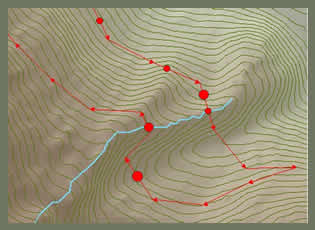
PeggerPegger is designed to assist the landowner in the initial design of forest roads. Using a contour theme Pegger can "peg in" a road from any point on the landscape at any grade. Pegger allows for quick analysis of alternative road designs in a GIS environment where other analysis tools can assist the planner in making educated decisions about road location. Pegger also assists in the editing of existing road themes by making available merge and spline functions to combine and smooth existing road data. Click here to view a streaming video presentation of Pegger. |
 |
![]()
![]()
CULSEDCulvert Placement to Minimize Road Sediment Delivery to Stream NetworksCULSED is a GIS decision support tool that runs within ArcMap 8.2. It was programmed by UW College of Forest Resources graduate student Flo Damian, and uses culvert placement as a method for reducing sediment delivery to stream networks from forest roads. For more information and a free download, click here. |
Modeling Overland Flow |
![]()
![]()
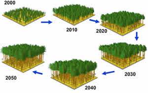 |
The Landscape Management SystemLMS is an evolving application designed to assist in landscape level analysis and planning of forest ecosystems by automating the tasks of stand projection, graphical and tabular summarization, stand visualization, and landscape visualization. LMS is implemented as a Microsoft Windows (TM) application that coordinates the activities of other programs (projection models, visualization tools, etc.) that makeup the overall system. Click on the link above to access the Free LMS Download page. Below is a report that summarizes the use of LMS to manage a tree farm located 20 miles west of Mt. Rainier. |
| The University of Washington College of Forest Resources Silviculture Laboratory and Yale University School of Forestry and Environmental Studies are working cooperatively with the Cradle of Forestry in America to develop forestry educational programs for K-12 audiences using the Landscape Management System. |
| Mission: The Cradle of Forestry in America Interpretive Association, in cooperation with the Cradle of Forestry in America, the USDA Forest Service, and other partners, will make available to this and future generations the birthplace of forestry and forestry education in America and will promote, demonstrate, and stimulate interest in and knowledge of the sustainable management of America's forest lands for the multiple benefits. |
The Landscape Management System: A Practical ApplicationBy: Christopher Townsend In 2002, the Coburg tree farm had identified
a problem (declining growth in a too-tightly packed forest),
and a possible solution (pay for thinning by selling poles).
The solution to the problem asked questions like: Aiding the Townsend family in the decision making process was the Landscape Management System (LMS). Click here to read a pdf of the report (to read this report, Adobe Reader is needed ). |
![]()
|
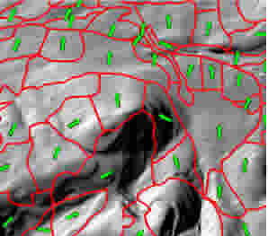
Forest stand boundaries on an analytically hillshaded digital elevation model arrows indicate calculated mean aspect per stand. |
LMS AnalystLMS Analyst is an Arcview extension to assist in the creation of Landscape Management System landscape portfolios. The current version calculates zonal mean slope, aspect and elevation for stands using a digital elevation model. LMS Analyst was designed and written by Phil Hurvitz - (phurvitz |
![]()
![]()
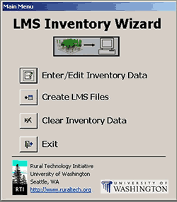 |
LMS Inventory WizardThe LMS Inventory Wizard is a tool to help foresters and landowners import their forest data into the Landscape Management System (LMS). Users can enter their inventory plot data into on-screen forms, and the inventory wizard will then generate files that can be imported into LMS. The LMS Inventory Wizard runs on Windows-based computers that have Microsoft Access installed. The LMS Inventory Wizard was developed by the Rural Technology
Initiative at the University of Washington and is available
for free download below. There is also a tutorial available
to demonstrate how to use this tool to create LMS portfolios. |
![]()
![]()
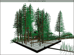 |
The Stand Visualization SystemSVS is a product of the USDA Forest Service, Pacific Northwest Research Station. The program is used to generate graphic images depicting stand conditions represented by a list of individual stand components, e.g., trees, shrubs, and down material. The images produced by SVS, while abstract, provide a readily understood representation of stand conditions. Images produced using SVS help communicate silvicultural treatments and forest management alternatives to a variety of audiences. |
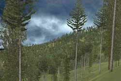
EnVision (Environmental Visualization System)EnVision is also a product of the USDA Forest Service, Pacific Northwest Research Station. It is designed to be a full featured rendering system for stand- and landscape-scale images. Applicable projects range from a few to several thousand acres. For more information and a Free Download of Envision, click on the link above. |
 |
![]()
![]()
Forestry References
| |
Consulting Forester Directory |
|
| WSU Cooperative Extension Natural Resource Sciences has put together a list of some of the Forestry Consultants for the state of Washington and neighboring states. The link above will take you to the WSU directory information page. | ||
Online
Tutorial -
|
 |
National Tax Management for Timberland Owners!Very few sections of the Internal Revenue Code are written specifically for timber. This means there is a considerable amount of interpretation involved. This website was developed to be used by timberland owners, as well as a reference source for accountants, attorneys, consulting foresters and other professionals who work with timberland owners by answering specific questions regarding the tax treatment of timber. |
| |
The Timberland Decision Support SystemTDSS was developed and made available by the Texas Forestry
Service. It provides excellent information on some common financial
concepts, along with easy-to-use calculators to facilitate
your decision making process. Anyone looking to make
a forestry related investment should check out this site.
|
| |
Log Marketing AssistanceSearch for log buyers in Oregon, Northern California, and Southwest Washington using the Oregon Log Buyer Database. Developed by Oregon State University Extension Service forestry faculty, the database is organized by county and offers information on the log requirements of each company listed, as well as contact information. |
| |
Forestry
Data Use public forestry data to find out current forest harvest volumes in Washington and the tax applied to their sales. You can also compare current data with historical trends. |
|
|
Washington State Secondary Wood Products DirectoryCINTRAFOR has added an on-line directory of value-added manufacturers
to its website. The directory is searchable by product, company
name or location, and includes an alphabetic listing of companies
as well.
|

