Summary statistics
The Washington State Forestland Database contains an extraordinary amount of information on the location, physical and political characteristics of forestland ownerships. The focus of this report is not to provide a comprehensive list of statistics or figures from the database but instead to document its various features and how it was created. Included below are a few statistics to demonstrate the capability of the database. Additional statistics by county can be found in Appendix D: Statistics. A detailed and extensive quantification of Washington’s forest land base will be the subject of subsequent papers and publications.
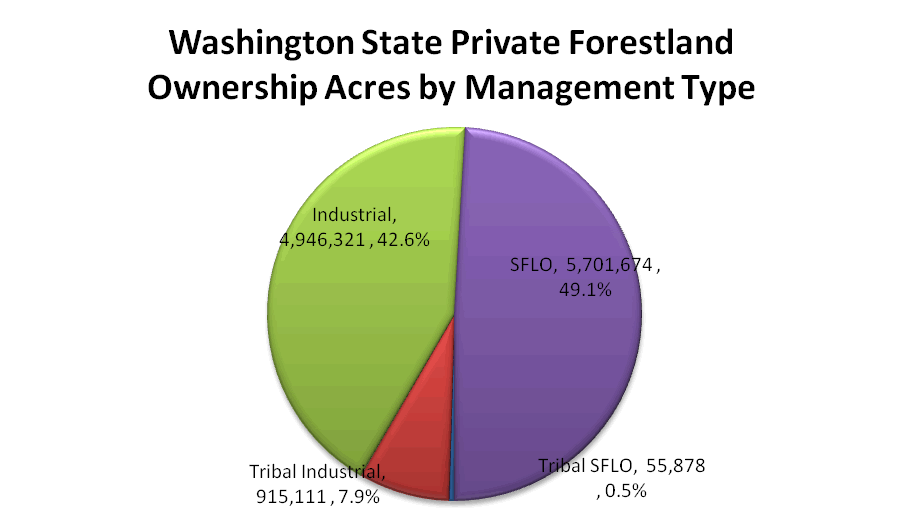
Washington State Private Forestland Acres by Management Type
The 11.6 million acres of private forestland in Washington State is split nearly evenly between larger industrial owners and smaller family forest landowners (or SFLO) as shown in Figure 8.
 |
| Figure 8: Washington State Private Forestland Ownership Acres by Management Type |

Washington Small Forest Land Owners Acreages by Size Class
The Washington State Forestland Database can be used to quantify acres and owners by size class as in Table 18. Parcel Acres includes the non‐forest portions of parcels whereas Forested Acres includes only the forested portions of those parcels.
Table 18: Washington Small Forest Land Owner Acreage by Size Class
| Size Class |
# Parcels |
# Owners |
Parcel Acres |
Forested Acres |
| <20 |
173,212 |
159,585 |
1,031,388 |
699,017 |
| 20-100 |
65,156 |
41,927 |
1,422,349 |
950,824 |
| 100-1000 |
34,927 |
12,418 |
2,032,996 |
1,143,292 |
| 1000-5000 |
8,741 |
1,058 |
997,956 |
382,256 |
| 5000+ |
1,162 |
98 |
216,971 |
59,982 |
| Total |
283,198 |
215,043 |
5,701,661 |
3,235,372 |
Product descriptions
The result of this research is three primary products: the Washington State Forestland Database, statistics on the numbers and acres of forestland parcels, and maps of the distribution and extent of private forestlands. The analysis and compilation of these statistics and the publication of maps will be the subject of future work.
Database
Components of the Washington State Forestland Database have been exported to an ESRI Personal Geodatabase for generating statistics and maps. This database can be used in Microsoft Access or with any ESRI ArcGIS product. The database consists of the Forestland table, and WRIA, WAU and County Feature Classes that can be used for mapping. Technical, political and legal considerations prohibit individual parcel boundaries and personal information from distribution in the Washington State Forestland Database product. Organizations and individuals needing more detailed sub‐WAU maps will need to contact researchers to discuss possibilities for collaboration. Information on how to access the Washington State Forestland Database can be found on the project website. Technical information about the attributes and structure of the database can be found in Appendix B: Attributes in the 2007 Washington State Forestland Database.
Statistics
An Excel spreadsheet with statistics on the numbers, acres and locations of private forestlands in Washington State is available on the project website. Sample state and county statistics can be found in the appendix. Additional statistics will be the subject of future work.
Maps
A few sample map graphics from the Washington State Forestland Database are included in the appendix. Higher‐resolution printable maps and graphics for presentations are currently under development and will be available on the project website. Requests for additional maps and graphics can be sent to Luke Rogers: lwrogers u.washington.edu. u.washington.edu.
Discussion
The Forestland Database is a powerful and flexible tool. There are several immediate possibilities for use, and certainly more will become apparent over time. The primary objective of the Database is to increase the understanding of forest ownership types, locations and relationships to other physical and political features. The platform that has been developed, while complex, is efficient to use and can quickly enumerate and visualize various statistics about forestland ownership.
As the database is updated with new information from counties researchers will be able to analyze land use change and parcelization (subdivisions of parcels). Using county assessor land use information any changes in the land use of parcels, particularly from a forested use to a non‐forested use will indicate forestland conversion allowing explicit quantification. By developing an archive of land use change and parcelization over time land use change forecast models can be developed.
Potential applications of the Forestland Database are:
- Economic implications of forest policy
- Identification of property improvements for fire and flood risk mitigation
- Identification of eligible ownerships for salmon habitat and stream improvement
- Bio‐fuel feedstock assessments
- Carbon accounting when combined with forest inventory
Limitations
There are many known limitations of the Washington State Forestland Database and while most have been detailed previously it is prudent to review the most critical of those here to ensure appropriate use of the database and its derivative products.
- Spatial accuracy: Each county assessor maintains their GIS and tax‐roll information to different standards of both format and accuracy. While many counties appear to have highly accurate parcel geometry many do not and the digital representations of parcels in their data can only be considered “cartoons”. When combined with the myriad datasets that were used to quantify forestland ownership significant errors are almost certainly introduced and are extraordinarily difficult to quantify. However, when data is aggregated at the county, regional or state scale, these errors are likely small.
- Pseudo‐Parcels: Many counties do not have GIS based parcel information and were not able to provide spatially explicit information for this project. In these counties, actual parcel locations were approximated using legal description information. The potential errors associated with using this information for spatial overlays are large and a validation test was run to determine the magnitude of this error. Caution must be exercised when using these pseudo‐parcels for local spatial analysis.
- Designated Forest Lands (DFL): According to WAC 458‐40‐530, the Washington Department of Revenue is responsible for determining current designated forestland values for County assessors. The Department of Revenue uses timber species, site index, and operability class to make these determinations. Therefore, County Assessor data does not contain accurate, current market value for properties in the DFL program. The risk of conversion figure in the database is therefore only calculated for parcels not enrolled in the DFL program where suitable market values exist.
- Forest Inventory: Modeling forest values for each parcel assumes bare ground. There is no current inventory information used in this database. Clearly current inventory on a parcel will affect the financial analysis and future work will attempt to utilize remotely sensed inventory assessments to improve the quality of the economic analysis.
- Ownership Information: Ownership data is collected individually by each County, and is often incomplete, as assessors are mainly concerned with equitable assessments and the collection of taxes. There is no statewide owner ID available and no straightforward method to integrate owners across the State, which makes determining total statewide ownership for each owner difficult. The result is that the number of owners stated in the statistics is overestimated for each owner that has property in more than one county. The net result of this overestimation however is presumed to be minor if not completely inconsequential.
- Forest Cover: In addition to land use information forest cover from the National Land Cover Dataset (NLCD) was used to identify forested parcels. The most recent NLCD data available for this analysis was from 2001 which includes satellite imagery from a variety of dates. The collected parcel data has dates around October 2007. The difference in dates between the land cover data and the assessor’s information is a source of error. It is likely that some parcels identified from forest cover as forestland have been converted to non‐forest uses and others have been re‐forested. The net effect of this temporal misalignment is unknown.
Additional Data Needs
Additional data sources have been identified that can be added to the database to increase its functionality however few of these datasets have been compiled at the statewide level.
- Urban Growth Areas, Zoning, Comprehensive Plans and Critical Areas: The State and many Counties have created and maintain additional GIS data that affect how individual parcels can be used and developed. Counties create and maintain zoning, comprehensive plans, and critical areas data sets. The Washington Department of Community, Trade & Economic Development maintains a statewide Urban Growth Area Boundary dataset.
- Conservation Status: There are several State programs with forest conservation goals, such as the Forest Riparian Easement Program (FREP), and non‐Governmental organizations such as the Cascade Land Conservancy and The Nature Conservancy with conservation easements, ownership, or development rights. Identification of these “protected” lands in the database would help provide context for priorities.
- Designated Forest Land Assessments: A market value assessment process for DFL lands should be developed based on recent market activity, proximity to other appraised lands and amenities or a combination of factors. A brief attempt was made to correlate sales, adjacent lands and proximity to amenities however no statistically significant factors were identified. A more rigorous approach would likely yield an appropriate method for modeling DFL highest‐and‐best‐use appraisals.
- LIDAR‐derived Forest Inventory Estimates: The current economic model for forest investment return is based on bare ground growth simulations. Economic profiles of individual ownerships could be more accurately quantified with knowledge of current forest inventories. While the acquisition of plot‐level inventory data for the state is not feasible, research suggests that reasonably accurate volume estimates can be developed from aerial LiDAR flights. With high‐resolution LiDAR data it is also possible to infer metrics on stand structure, a key component for modeling wildlife habitat and other biological systems.
Conclusions
The Washington State Forestland Database combines land ownership, land use and assessment information with physical characteristics of the land to develop economic, social and environmental metrics about the forest land base. The spatially explicit information in the database allows for analysis at the watershed, county and state level. This high‐resolution dataset can be used to produce maps, statistics and models at multiple scales and when combined with additional datasets becomes a powerful tool for analyzing natural resource lands.
Statistics and maps on the numbers of parcels, acres and owners of forestland in the State of Washington are presented here as a basic example of the kinds of information that can be summarized and visualized using the Forestland Database. Future research at the Rural Technology Initiative will provide additional quantification and maps of the forest land base and by incorporating new data from counties forestland change will be measured. Over time the Washington State Forestland Database will become a comprehensive platform for understanding how forest land ownership and land use is changing enabling new science, research and informed policy to emerge.
Works Cited
Alexander, R.R., D. Tackle, and W.G. Dahms. Site indexes for Lodgepole pine, with corrections for stand density: Methodology. Research Paper RM‐29, Fort Collins, CO: U.S. Department of Agriculture, Forest Service, Rocky Mountain Forest and Range Experiment Station, 1967.
Barrett, J.W. Height Growth and Site Index Curves for Managed, Even‐aged Stands of Ponderosa Pine in the Pacific Northwest. Research Paper PNW‐232, Portland, OR: U.S. Department of Agriculture, Forest Service, Pacific Northwest Forest and Range Experiment Station, 1978.
Cochran, P.H. Site Index and Height Growth Curves for Managed, Even‐aged stands of Douglas‐fir East of the Cascades in Oregon and Washington. Research Paper PNW‐251, Portland, OR: U.S.Department of Agriculture, Forest Service, Pacific Northwest Forest and Range Experiment Station, 1979.
Forest Practice Rules. 2009. http://www.dnr.wa.gov/BusinessPermits/Topics/ForestPracticesRules/Pages/fp_rules.aspx (accessed February 10, 2009).
Gray, Andrew N., Charles F. Veneklase, and Robert D. Rhodes. Timber resource statistics for nonnational forest land in western Washington, 2001. Portland, OR: U.S. Department of Agriculture, Forest Service, Pacific Northwest Research Station, 2005.
King, James E. Site index curves for Douglas‐fir in the Pacific Northwest. Paper 8, Centralia, WA: Weyerhaeuser Company, Forestry Research Center, 1966.
Lippke, B., L. Mason, K. Zobrist, K. Ceder, E. Oneil, and J. McCarter. Timber Supply and Forest Structure. In The Future of Washington’s Forests and Forestry Industries, Final Report, July 2007. Prepared for the Washington Department of Natural Resources, Seattle, WA: University of Washington, College of Forest Resources, 2007, 2‐123.
Long, J.N., J.B. McCarter, and S.B. Jack. "A modified density management diagram for coastal Douglas‐fir." Western Journal of Applied Forestry 3, no. 3 (1988): 88‐89.
McArdle, R.E., W.H. Meyer, and D. Bruce. The yield of Douglas fir in the Pacific Northwest. Technical Bulletin 201, U.S. Department of Agriculture, 1949.
Mouton, Adam. Generating stream maps using LiDAR derived digital elevation models and 10‐m USGS DEM. Thesis (M.S.), University of Washington, 2005.
Multi‐Resolution Land Characteristics Consortium (MRLC). "National Land Cover Database Zone 01 Land Cover Layer (NLCD 2001)." National Land Cover Database. [raster digital data]. September 2003. http://www.mrlc.gov/multizone_download.php?zone=1 (accessed February 15, 2008).
Reineke, L. H. "Perfecting a stand‐density index for even‐aged forests." Journal of Agriculture Research 46 (1933): 627‐638.
Smith, W. Brad, Patrick D. Miles, John S. Vissage, and Scott A. Pugh. Forest Resources of the United States, 2002. St. Paul, MN: U.S. Department of Agriculture, Forest Service, North Central Research Station, 2003.
Straka, T. J., and S. H. Bullard. "Land Expectation Value Calculation in Timberland Valuation." The Appraisal Journal, 1996: 399‐405.
Washington Department of Ecology. "Water Resource Inventory Areas of Washington (WRIA)." Ecology’s Spatial Datasets. [vector digital data]. May 2000.
http://www.ecy.wa.gov/services/gis/data/data.htm (accessed May 1, 2008).
Washington Department of Natural Resources. "Cadastre DNR Managed Land Parcels." Available GIS Data. [vector digital data]. April 2007. http://fortress.wa.gov/dnr/app1/dataweb/dmmatrix.html (accessed May 1, 2008).
—. "County." Available GIS Data. Unknown. http://fortress.wa.gov/dnr/app1/dataweb/dmmatrix.html (accessed August 8, 2008).
—. "County." Available GIS Data. [vector digital data]. Unknown. http://fortress.wa.gov/dnr/app1/dataweb/dmmatrix.html (accessed August 8, 2008).
—. "East/West Dividing Line." Forest Practices GIS Spatial Data Sets. [vector digital data]. October 2002. http://dnr.wa.gov/BusinessPermits/Topics/ForestPracticesApplications/Pages/fp_gis_spatial_data.aspx (accessed May 30, 2008).
—. "Forest Practices Wetlands." Forest Practices GIS Spatial Data Sets. [vector digital data]. December 2007. http://dnr.wa.gov/BusinessPermits/Topics/ForestPracticesApplications/Pages/fp_gis_spatial_data.aspx (accessed May 22, 2008).
—. "NDMPL (Washington State Non‐DNR Major Public Lands)." Available GIS Data. [vector digital data]. October 2007. http://fortress.wa.gov/dnr/app1/dataweb/dmmatrix.html (accessed May 1, 2008).
—. "Site Class." Forest Practices GIS Spatial Data Sets. [vector digital data]. August 2001. http://dnr.wa.gov/BusinessPermits/Topics/ForestPracticesApplications/Pages/fp_gis_spatial_data.aspx (accessed May 1, 2008).
—. "Transportation (Statewide)." Available GIS Data. [vector digital data]. April 2008. http://fortress.wa.gov/dnr/app1/dataweb/dmmatrix.html (accessed May 1, 2008).
—. "Washington State Water Body (WBWS) Hydrography." Available GIS Data. [vector digital data]. April 2008. http://fortress.wa.gov/dnr/app1/dataweb/dmmatrix.html (accessed May 1, 2008).
—. "Washington State Watercourse (WC) Hydrography." Available GIS Data. [vector digital data]. April 2008. http://fortress.wa.gov/dnr/app1/dataweb/dmmatrix.html (accessed May 1, 2008).
—. "Watershed Administrative Units (WAU)." Forest Practices GIS Spatial Data Sets. [vector digital data]. April 2006. http://dnr.wa.gov/BusinessPermits/Topics/ForestPracticesApplications/Pages/fp_gis_spatial_data.aspx (accessed May 1, 2008).
Washington State Department of Community, Trade & Economic Development / Washington Department of Ecology. "Urban Growth Area Boundaries." [vector digital data]. January 2008. Acquired via email from Sam Wentz samwcted.wa.gov (accessed October 1, 2008).
Washington State Department of Transportation. "City Limits of Washington State." WSDOT GeoData Distribution Catalog. [vector digital data]. November 2007. http://www.wsdot.wa.gov/mapsdata/GeoDataCatalog/ (accessed February 14, 2008).
Washington State Timber Harvest Reports. 2009. http://www.dnr.wa.gov/BusinessPermits/Topics/Budget/Pages/washington_state_timber_harvest.aspx (accessed February 10, 2009).
|