Final Report
Luke W. Rogers and Andrew G. Cooke
3/24/2009
UNIVERSITY OF WASHINGTON –COLLEGE OF FOREST RESOURCES
Prepared under contract for the USDA Forest Service
Executive Summary
Beginning with the passage of Washington State House Bill 2091, otherwise known as the Salmon Recovery Act (1998), the State has had an interest in quantifying the numbers, acres and other characteristics of small forest landowners (SFLO) and their lands. The Washington State Forestland Database was developed to provide a comprehensive platform for understanding the spatial characteristics of all private forestland ownership in the state, including family forests. The Database is an ArcGIS 9.2 Geodatabase and designed for use in Microsoft Access or any ESRI ArcGIS product.
The Washington State Forestland Database combines land ownership, land use and assessment information with physical characteristics of the land to develop economic, social and environmental metrics about the forest land base. The spatially‐explicit information in the database allows for analysis at the watershed, county and state level. This high‐resolution dataset can produce maps, statistics and models at multiple scales. Over time it will become a comprehensive platform for understanding how forest land ownership and land use is changing, thereby enabling new science and research to inform public policy analysis, debate and action.
Three primary products were developed: the Washington State Forestland Database, statistics on the numbers and acres of forestland parcels and maps of the distribution and extent of private forestlands. Statistics derived from the Database reveal that 215 thousand small forest landowners own 5.7 million acres of forestland, half of the 11.6 million acres of private forestland in the state. Over 89 thousand of those small forest landowners have ownerships greater than 10 acres and 55 thousand own more than 20 acres. The maps of the distribution of forestlands in the State of Washington show that small forest landowner properties, often adjacent to suburban and exurban lands, provide a critical buffer between upland industrial forestlands and lowland residential areas.
To map and quantify the location and features of forestlands, parcel data and assessor’s attributes from the state’s 39 counties were collected and normalized into a common statewide format. In counties where no GIS parcel data exists, GIS “pseudo‐parcels” were developed from assessor’s legal descriptions. The three million individual parcels in the normalized database were then compared to forestland cover maps developed from Landsat satellite imagery as part of the National Land Cover Dataset. In addition to the land‐cover assessments, assessor’s tax‐rolls were used to identify forested land uses as well as participation in forestland tax programs. Forest land parcels as small as 1 acre were included in the database.
Owner names, categories and style of forest management were classified into five “owner type categories”: government, corporate, tribal, conservation and other private. Using owner type and number of acres, parcels were classified into management types: industrial or small forest land owner. By use of the Landscape Management System, the management regimes and the physical characteristics of the property, including site index, forest type and regulatory buffers, were modeled to develop a financial profile for each forest parcel. In addition, multiple physical and political characteristics were computed for each parcel such as distance to development, proximity to roads, distance from a designated Urban Growth Area and contiguous ownership area.
Table of Contents
 Download PDF copy (10MB) Download PDF copy (10MB)
Executive Summary
Table of Contents
List of Figures
List of Tables
Acknowledgements
Introduction and Background
Project Overview
Methodology
Creating a Statewide Parcel Database
Parcels Working Group
Data Collection and Normalization
Products
Caveats
Identifying Forestlands
Determining Forest Acres
Physical Characteristics
East/West
Buffers
WRIA
WAU
Streams
Proximity
Economic Analysis
Owner Classes
Management Types
Modeling forest growth
Risk of conversion
Results
Tabular/GIS comparison
Purpose
Methods
Results
Discussion
Summary statistics
Washington State Private Forestland Acres by Management Type
Washington Small Forest Land Owners Acreages by Size Class
Product descriptions
Database
Statistics
Maps
Discussion
Limitations
Additional Data Needs
Conclusions
Works Cited
Appendix A: Attributes in the 2007 Washington State Parcel Database
Product Description
Database Design
Attributes
Parcels Table
Organizations Table
TaxRoll Table
Land Use Table
TaxRollHasNames Table
Names Table
NormalizedNames Table
Appendix B: Attributes in the 2007 Washington State Forestland Database
Product description
Database Design
Attributes
Land Use
Ownership Classification
Management Type
Physical Attributes
Economic Attributes
Appendix C: GIS Datasets Used
Appendix D: Statistics
Appendix E: Maps
Appendix F: Land Use Codes in the Forestland Database
List of Figures
Figure 1: County Participation in the Washington State Forestland Database
Figure 2: Entity Relationship Diagram of the 2007 Washington State Parcel Database
Figure 3: Parcel Data Availability for Washington State
Figure 4: GIS Parcels for Lewis County
Figure 5: Pseudo‐Parcels for Lewis County
Figure 6: GIS Parcels around Wildwood and Vader, Lewis County
Figure 7: Pseudo‐Parcels around Wildwood and Vader, Lewis County
Figure 8: Washington State Private Forestland Ownership Acres by Management Type
Figure 9: Washington State Parcel Database Entity Relationship Diagram
Figure 10: Washington State Forestland Database Entity Relationship Diagram
Figure 11: Private Forests and Public Lands in Washington State
Figure 12: Washington Small Forest Land Owners and Forest Cover
Figure 13: The Percent of County Area Owned by Small Forest Land Owners
Figure 14: The Number of Small Forest Land Owner Parcels per County
Figure 15: Small Forest Land Owner Density, Counties
Figure 16: The Percent of WAU Area Owned by Small Forest Landowners
Figure 17: The Number of Small Forest Land Owner Parcels per WAU
Figure 18: Small Forest Land Owner Density, WAUs
List of Tables
Table 1: Parcels Working Group Participants
Table 2: Sample State, Federal and Private Applications
Table 3: Wetland Buffer Distances
Table 4: Stream and Body of Water Buffer Distances
Table 5: Site index, SDI Max, and rotation length for site class and ownership in Western Washington
Table 6: Simplified harvest by buffer zone for western Washington
Table 7: Site/owner class scenarios for western Washington
Table 8: Site index, SDI Max, and rotation length for site class and ownerships in Eastern Washington
Table 9: Simplified harvest by buffer zone for eastern Washington
Table 10: Site/owner class scenarios for eastern Washington
Table 11: Uneven‐aged scenarios for Eastern Washington
Table 12: Acres and Percent of County in Forestland Ownership by Owner Class
Table 13: Acres and Percent of Ownership in Buffers by Management Type
Table 14: Length of Streams in Feet
Table 15: Length of Streams in Feet for SFLO Parcels and Percent of Tota
Table 16: Length of Streams in Feet for Industrial Parcels and Percent of Total
Table 17: Length of Streams in Feet for all Private Parcels and Percent of Total
Table 18: Washington Small Forest Land Owner Acreage by Size Class
Table 19: Forestland Database primary/foreign key relationships for thematic mapping
Acknowledgements
| Luke Rogers |
Principal Investigator |
| Andrew Cooke |
Research Consultant |
| Ara Erickson |
Research Consultant |
| James McCarter, Ph. D. |
Research Scientist |
The Family Forest Foundation and the Washington State Farm Forestry Association advocated for funds to develop a database of family forestlands in Washington State, resulting in a 2006 federal budget allocation of $500,000 for a "private landowner database." This allocation culminated in a USDA Forest Service contract with the Rural Technology Initiative to create the Washington State Forestland Database. This project could not have been completed without their combined efforts. We would like to thank the FFF and the WFFA for their unrelenting efforts to help quantify and better understand the interactions between policy and science and for their continued support of a project that has benefits far beyond their parcels of forestland.
In addition, David Jennings at the Washington State Department of Health has been an advocate and supporter of the Washington State Parcel Database, the foundation upon which the Forestland Database was constructed. The Department of Health allocated $210,000 to RTI to continue development of the Parcel Database and ensure its long‐term success and availability. We thank David for his work in co‐chairing the Parcels Working Group and for championing a statewide cadastre at our State agencies.
Much of the success in assembling the first versions of both the Parcel and Forestland Databases can be attributed to the hard work of RTI staff Ara Erickson (now with the Cascade Land Conservancy) and Steve Stinson of the Family Forest Foundation. Ara’s relentless commitment to deadlines, eternally optimistic outlook and cheerful demeanor were critical to developing sustainable and trusting relationships with the counties. Steve Stinson’s tireless pursuit of good science, his willingness to track down even the most obscure detail to ensure accurate statistics from the Database and the Family Forest Foundation’s support of this project will have enduring value for our State.
We thank Brad Coston for his support of both hardware and software on the servers needed to manage, store, backup and process data for this project. We thank Matthew McLaughlin for his help in sifting through tens of thousands of records in the database to validate methods and ensure accuracy. We thank Brian Boyle, Gordon Bradley, Alicia Robbins, Bob Rose and members of our Technical Review Committee for sharing their knowledge and thoughtful advice about assumptions and methods.
Lastly, and most importantly, we thank the county assessors, their GIS staff and the Washington State Association of County Assessors for their participation in both the Parcel and Forestland Database projects. Without the diligent work of our county assessors, their appraisers and their GIS personnel we could not have developed such a comprehensive platform to quantify and improve understanding of our State’s natural resource lands. The data counties assemble and maintain is a critical resource for the State and we appreciate their willingness to share their data and knowledge.

Introduction and Background
Beginning with the passage of Washington State House Bill 2091, otherwise known as the Salmon Recovery Act, the State has had an interest in quantifying the numbers, acres and other characteristics of small forest landowners (SFLO) and their lands. In 2001, the Rural Technology Initiative (RTI) began this work by assembling the Washington State Department of Natural Resources Small Forest Landowner Database from county tax records to create the first spatially explicit database of family forest parcel information. At the time, very few of Washington’s counties had Geographic Information Systems (GIS), making spatial location of the parcels problematic and labor‐intensive. Legal description information from the county assessors was used to geo‐locate each individual parcel from the tabular tax records to a specific township, range and section. Although this information was very coarse, it presented us for the first time with a picture of the unique spatial distribution and geographic relevance of family forests in Washington State.
Since 2001 most counties have acquired GIS capability and are managing parcel boundaries and tax rolls digitally. The continued development of county assessor's GIS‐based tax rolls brings new opportunities to refine and reevaluate family forestland metrics in the state. In 2005 a partnership of The Family Forest Foundation and the Washington State Farm Forestry Association was successful in advocating for funds to develop a database of family forestlands in Washington State and in the Federal Government's 2006 budget $500,000 was allocated for a "private landowner database in Washington State." Based on their experience with quantifying the forest land base in Washington State and their knowledge of county GIS parcel data the Rural Technology Initiative at the University of Washington's College of Forest Resources was awarded a contract from the US Forest Service to develop a Washington State Forestland Database.
The development of the Washington State Forestland Database consists of six primary components: collection of county GIS parcel data and associated assessor tax rolls from Washington's 39 counties; normalization of acquired data into a single statewide parcel database; analysis and integration of physical and political features; determination of landowner class and type; modeling forest management opportunity and economics; and developing and documenting products for use by others. By repeating this process annually or as funding allows researchers also hope to be able to analyze trends over time. Recognizing that federal appropriations and state budget allocations are an unreliable source of funding researchers chose to seek partnerships with state and federal agencies that would benefit from a Washington State Parcel Database and in collaboration with dozens of partners created and now co‐chair the Washington State Parcels Working Group.
The Forestland Database is an extensive platform for understanding the changing forest land base and implications for the economy, ecology, wildlife and citizens of Washington State. By combining information on natural resources, environmental and land use regulations, and land ownership, scientists and policy analysts can gain insight into the complex interactions between public and private objectives. Over time, the database will enable researchers to detect changes in the forest land base and perhaps quantify the effectiveness of policy decisions.
Project Overview
To map and quantify the location and features of forestlands in the state of Washington data parcel data and assessor’s attributes from the state’s 39 counties was collected and normalized into a common statewide format. The three million parcels in the normalized database were then compared to forestland cover maps developed from Landsat satellite imagery as part of the National Land Cover Dataset. In addition to the land‐cover assessments, assessor’s tax‐rolls were used to identify forested land‐uses and participation in forestland tax programs. Using this method forest land parcels as small as 1 acre were included in the analysis.
To differentiate the types of owners and their style of forest management owner names were classified into five owner type categories: government, corporate, tribal, conservation, and other private. Using owner type and number of acres parcels were classified into management types: industrial or small forest land owner. Based on surveys done for the Future of Washington’s Forests Report (Lippke, et al. 2007) industrial and small forest land owners manage their lands at different intensities. Using the Landscape Management System the management regimes and the physical characteristics of the property like site index, forest type and regulatory buffers were modeled to develop a financial profile for each forest parcel. By comparing the financial profile of individual parcels with the county assessor’s appraised market values for the properties a relative risk of conversion metric was developed. In addition, multiple physical and political characteristics were computed for each parcel such as distance to development, proximity to roads, near an urban growth area, and contiguous ownership area.
Using the Washington State Parcel Database statistics on the number of owners, private forestland acres, forested riparian areas, risk of conversion and other metrics were tabulated. Maps showing the spatial extent and distribution of industrial and small forest land owners around the state were developed and thematic maps of the densities and quantities of these ownerships were produced. The database, statistics and maps quantify in exquisite detail the current forestland ownership patterns in the State and provide a platform for quantifying forestland change in the future.
Methodology
Creating a Statewide Parcel Database
The Washington State Forestland Database is built upon county assessor GIS parcels and related tax roll information. To create a foundation for the Forestland Database the concept of a Washington State Parcel Database was presented to interested parties and the Parcels Working Group was established.
Parcels Working Group
In October 2006 a group of federal, state, tribal, non‐profit and local government participants came together to explore whether there was interest in and a willingness to pursue the development and coordination of a statewide parcel framework dataset that would be accessible to various participating agencies. As a substantial portion of the Washington State Forestland Database would be built from county parcel data, researchers actively participated in the meeting and the principal investigator, Luke Rogers, along with a representative from the Washington State Department of Health, David Jennings, were unanimously appointed to co‐chair the newly formed Washington State Parcels Working Group. Participation and leadership in the Working Group has potential long‐term benefits for the Washington State Forestland Database project.
Early in the project researchers recognized that utilizing federal funds as a seed to develop a long‐term program would have enduring value for understanding forestland conversion, ownership and conservation trends. However, the collection, normalization and assembly of a statewide parcel database is costly. An opportunity existed to reduce government redundancy, increase efficiency, reduce taxpayer’s burden and provide a well documented, common dataset for use by government partners by producing a single statewide parcel database annually and sharing it among government. Previously, many individual state and federal agencies were periodically contacting counties to acquire parcel data. License agreements with counties were often restrictive and did not allow for sharing of parcel data or derivative products. Therefore, each agency was collecting and maintaining parcel data independently inflating the cost to taxpayers.
By helping establish the Parcels Working Group and collaborating with dozens of state and federal agencies researchers hope to: 1) reduce redundancy and increase timeliness and quality of statewide parcel data, 2) provide a common platform for land ownership related questions in Washington State, 3) leverage limited federal funds to develop a Washington State Parcel Database program, 4) share the normalized parcel data and derivative projects among government users. Over time researchers hope the cost of producing the Washington State Parcel Database can be distributed among the many state and federal government agencies benefiting from the use of the normalized statewide data. As the most expensive component of, and foundation for, the Washington State Forestland Database the cost of analyzing forestland trends over time can be significantly reduced by working collaboratively with the Parcels Working Group.
Accomplishments for the Parcels Working Group from October 2006 through December 2008 include:
- Conducted a parcel data "consumer survey"
- Conducted a parcel data "use case" assessment
- Developed a "Statement of Intent" about how we intend to interact with the Counties
- Fostered a open, collaborative and positive working environment between state, federal and local participants
- Developed a comprehensive website about the project documenting every phase of the effort
- Developed and released the 2007 Washington State Parcel Database to Working Group partners
- Identified opportunities to enhance the existing Public Records law in the State of Washington with respect to parcel data, "commercial use" and a "list of names"
- Held fifteen Parcels Working Group meetings in Olympia
Table 1: Parcels Working Group Participants.
| Group |
Participants |
| Local |
Adams, Asotin, Benton, Chelan, Clallam, Clark, Columbia, Cowlitz, Douglas, Ferry, Franklin, Garfield, Grant, Grays Harbor, Island, Jefferson, King, Kitsap, Kittitas, Klickitat, Lincoln, Mason, Okanogan, Pacific, Pend Oreille, Pierce, San Juan, Skagit, Skamania, Snohomish, Spokane, Stevens, Thurston, Wahkiakum, Walla Walla, Whatcom, Whitman, WA Association of Counties |
| State |
Community Trade and Economic Development, Health, Office of Financial Management, Natural Resources, Fish and Wildlife, Social and Health Services, Transportation, Revenue, Ecology, Inter Agency Committee, Information Services, Secretary of State, Information Services Board, Geographic Information Technology Committee, Washington Geographic Information Council, Emergency Management Division, State Patrol, Conservation Commission, Archeological and Historic Preservation, Legislative staff |
| Federal |
US Geological Survey, Bureau of Land Management, Federal Geographic Data Committee, Environmental Protection Agency, United States Forest Service, US Bureau of Reclamation, Federal Emergency Management Agency, Department of Homeland Security |
| University |
University of Washington |
| Tribal |
Quinault Indian Nation, Northwest Indian Fisheries Commission |
| Non-Profit |
Family Forest Foundation, Washington Farm Forestry Association |
Table 2: Sample State, Federal and Private Applications.
| Topic |
Agency and Application |
| Climate Change |
Ecology - Forest carbon accounting
WSU Energy - Biomass and bio-fuel assessment
UW - Land use forecasting impacts |
| Environmental |
Ecology - Water quality monitoring
Natural Resources - Salmon recovery prioritization
Ecology - Resource land conversion
Health - Well head protection and notification
|
| Emergency Management |
Emergency Management - Vulnerable populations
Office of the Insurance Commissioner - Damage assessments
Military - Critical infrastructure
State Patrol - aviation guidance
|
| Business Development |
Facility location
Market assessments
Real estate |
| Social and Health Services |
Association of Sheriffs and Police Chiefs - Sex offenders & school zones
Social and Health Servies - Foster parent prioritization |
Data Collection and Normalization
Collect Data from Counties
In the summer of 2007, the 39 counties in Washington State were contacted about providing parcel data to the Washington State Parcel Database. There were varying levels of interest and participation from individual counties. A key goal of the project was to not require special effort from counties in terms of the data they provide the database, but rather to take their current data as is. As a result county data was provided in many formats, with non‐standardized attributes and attribute names.
To aid the data collection process a website was designed to store information on county contacts, how to acquire data, phone and email conversions, and the data itself. The public facing portion of that website can be found on the web at http://depts.washington.edu/wagis/projects/parcels/producers/. Initially researchers contacted counties in August of 2007 via email and then followed up with phone calls and/or additional emails on approximately one month intervals. The bulk of the parcel data and assessor attributes were collected from September to December 2007. A few counties required additional help to extract data from their back‐end systems. Wahkiakum County for example had no way to digitally extract data from their legacy database system. Working with the county assessor and a contracted consultant we designed and implemented a data extraction program that regularly exports the tax roll for public records requests and for use in other applications.
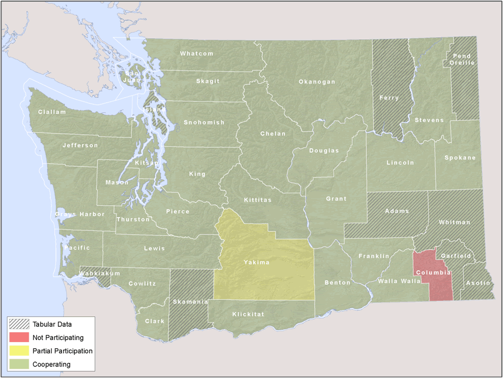
Ultimately data from all but 1 of Washington's 39 counties was acquired for use in the Washington State Forestland Database (Figure 1). However, many counties still do not have GIS‐based tax rolls and were only able to provide tabular tax rolls with legal description information such as Township, Range and Section which could be referenced back to the public land survey system.
 |
| Figure 1: County Participation in the Washington State Forestland Database. |
List of Attributes
The first step in normalizing the county data was to develop a set of standard attributes. All told, there were 1982 different attributes provided by the counties. These were rigorously examined to find common attributes. Due to differences in naming practices from county to county, the 1982 attributes could be reduced to 150 common attributes. To determine which attributes would be present in the Washington State Parcel Database, two decision rules were used. Firstly, if an attribute was present in 80% of the counties, then it was included. Secondly, all market and taxable value information, regardless of the number of counties using a particular attribute, was included.
Development of PseudoParcels
The second step in normalizing the data was to create placeholder polygons for counties that did not have GIS parcel data. Using either the legal description information or the assessor's parcel identification number which is most often a concatenation of Township, Range and Section, a program was written to place representative parcels within approximately the same geographic area. Using the section polygons of the Public Land Survey System (PLS) data from the Washington State Department of Natural Resources each parcel was geographically located. For parcels that were not able to be located due to missing or incomplete legal descriptions and/or parcel ID numbers that were not based on PLS locations parcel polygons were located in the most accurate geographic area possible. For example, in Island County properties located in Oak Harbor had non‐PLS based parcel id numbers. For those parcels the Office of Financial Management Cities layer (Washington State Department of Transportation 2007) was used to define the extents of the Oak Harbor area and each parcel was randomly located within the city boundary. Many parcels in Skamania County had no spatially identifying information and were randomly located within the county. So, depending on the county different spatial accuracies exist for individual parcels. A test of the relative accuracy of using these pseudo‐parcels for generation of statewide statistics is evaluated in the results section.
FME Used to Transform Data
The third step in normalizing the data was to convert the data from the various formats provided by the county to a standardized GIS database format. The software, Feature Manipulation Engine (FME), produced by Safe Software, was used for this purpose. It is an Extract, Translate, and Load (ETL) program for GIS data. A data normalization program was created for each county which read in the original data, renamed and normalized the attributes, and deleted unwanted attributes. Many of the attribute translations were straightforward such as extracting house number, street, city, state and zip code information from a single address field. Other attributes like land use required more complex translation tables to convert county specific land use codes into a normalized statewide standard. The FME software also performed several spatial comparisons described below to address errors identified in the data.
Correcting Errors in the Data, QA/QC
While processing and normalizing the data for each county to a standardized statewide dataset, five possible procedures could have been applied: Removing Duplicate Parcels, Flattening Stacked Parcels, Creating Multipart Parcels, Removing Duplicate Names, and Removing Duplicate Tax Rolls.
The data for each county was tested to see whether or not these five procedures were applied. For each of these procedures applied in a county, one test parcel to which a process was applied was selected and tested to ensure the procedure was applied correctly.
A parcel to which none of the procedures was applied was also tested to make sure all of the normalized attributes in the original data were correctly transferred to the final dataset. It is therefore possible that six data quality tests were performed for each county.
The following five Procedures were performed in order on the data for each county in FME.
- Removing Duplicate Parcels
There are two or more polygons representing a single parcel in the original data. They have the same geometry and identical attribute information. These are assumed to be multiple copies of the same parcel, and so duplicates are removed leaving a single polygon and single set of attribute information in the final database. A duplicate field was created in the database recording how many duplicates of each parcel were in the original data.
- Flattening Stacked Parcels
There are two or more polygons representing a parcel in the original data, however, while sharing the same geometry, they have different attributes. These are assumed to be multiple owners for the same parcel. The polygon only needs to be in the final database a single time, but all original attribute information for the different owners needs to be retained. A stack field was created in the database recording how many stacked polygons there were in the original data for each parcel.
- Creating Multipart Parcels
There are two or more polygons in the original data with different geometries but identical attribute information. It is assumed that these parcels are all owned by the same owner. The original polygons are all retained as a single, multipart polygon, but duplicate versions of the attributes are removed. Only a single copy of the attribute information is needed in the final database. A multipart field was created in the database recording how many parcels were aggregated into each multipart polygon.
- Removing Duplicate Tax Rolls
Two or more parcels in a county have identical tax roll attributes. These attributes only need to be in the final database a single time. A duplicate tax roll field was created in the database recording how many of the original parcels shared each set of tax roll attributes.
- Removing Duplicate Names
Two or more parcels in a county have the same name attributes in the original data. These attributes only need to be in the final database a single time. A duplicate name field was created in the database recording how many of the original parcels shared each set of name attributes.
Products
Final Attributes and Database Format
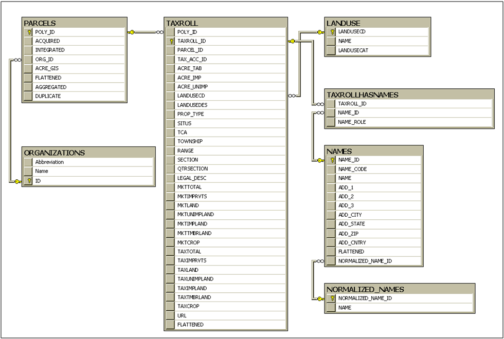
The Washington State Parcel Database is made up of seven related tables, as presented in Figure 2. The attributes in each table are described in Appendix A: Attributes in the 2007 Washington State Parcel Database. Not all attributes are collected by each data providing organization, and therefore not all attributes are available for all parcels.
 |
| Figure 2: Entity Relationship Diagram of the 2007 Washington State Parcel Database. |
Caveats
While the Washington State Parcel Database has extraordinary utility in many applications there are some notable caveats that must accompany its use. The primary purpose for which assessors develop GIS‐based parcel data is for the equitable taxation of property values. Many assessors utilize Computer Assisted Mass Appraisal (CAMA) systems that rely on both spatial and tabular information to appraise and assess property tax. For these systems to operate effectively only a reasonable representation of the true location and size of individual properties is required. The spatial accuracy of these GIS‐based systems is variable between counties and even within counties with many parcels represented hundreds of feet from their true location. For this reason many assessors refer to these GIS‐based parcels as “cartoon” representations and state that they are not accurate or reliable for spatial analysis.
Anecdotal experience using these cartoon representations of parcels has demonstrated that most are within tens of feet of their true location, especially in more populated areas. However, considerable variability exists and caution using these data is warranted. For statewide analyses the use of these data for generating statistics and maps of general ownership patterns, land use and appraisal values is appropriate. At the sub‐county level the use of the Washington State Parcel Database for evaluating individual properties or groups of properties can only hint at the true on‐the‐ground conditions and is no substitute for field visits or conversations with individual county assessor’s offices.
The transformation of the original county assessor’s data into the normalized Washington State Parcel Database further blurs the accuracy and precision of the spatial geometry and attributes of these cartoon representations. The spatial geometry of the original parcels is transformed, attributes are normalized using translation tables, and other attributes are eliminated entirely. Many of the pseudo‐parcels are spatially represented far from their true location and given the random nature in which these pseudo‐parcels are created many overlap one‐another making spatial analyses difficult and error prone.
Identifying Forestlands
Determining Forest Acres
The 2007 Washington State Forestland Database is a subset of the 2007 Washington State Parcel Database. A parcel must meet acreage and forest cover requirements in order to be included in the Forestland Database. Forestland parcels were identified using both forest cover information and land use information.
Forest Cover from Satellite Imagery
The first method is based on satellite imagery collected and processed by the Multi‐Resolution Land Characteristics Consortium. The MRLC (http://www.mrlc.gov/) "is a group of federal agencies who first joined together in 1993 to purchase Landsat 5 imagery for the conterminous U.S. and to develop a land cover dataset called the National Land Cover Dataset (http://landcover.usgs.gov/natllandcover.php). In 1999, a second‐generation MRLC consortium was formed to purchase three dates of Landsat 7 imagery for the entire United States and to coordinate the production of a comprehensive land cover database for the nation called the National Land Cover Database (NLCD 2001)." From the NLCD 2001 data, three classes, 41, 42, and 43, Deciduous Forest, Evergreen Forest, and Mixed Forest respectively, were used to create a presence/absence forest dataset. If a pixel was in one of these three classes, it was classified as forest, if it was not, it was classified as non‐forest. This presence/absence information was used to measure the acreage of forest cover (NLCD Forest Acres) in each parcel. Using this method, a Forestland parcel must be at least one acre in size, and must contain at least one‐half acre of forest.
Assessor Landuse Codes
A second method used to determine Forestland examined whether or not each parcel was enrolled in a forestland tax program. County Assessors assign parcels in these programs a land use code of 87, 88, 92 or 95. Parcels in these programs have requirements for how their forests are managed. It can be assumed that even if there is not forest cover present on a parcel in the satellite imagery that the entire parcel is being managed as forest and is therefore included in the Database. The Forest Acres attribute for parcels in forest tax programs is equivalent to the parcel acreage, rather than the NLCD forest cover acres.
Physical Characteristics
East/West
For the purposes of this database, every parcel in the state is considered to be on either the east or west side of the Cascade Crest. The Washington Department of Natural Resources forest management rules, as described in the Washington Forest Practices Rules and Regulations (Forest Practice Rules 2009), differ for each side of the State. It is therefore necessary to determine the side of the State in which each parcel lies in order to model stream buffers, and forest growth.
The DNR maintains an east west dividing line for the State and a State boundary line. By combining these two boundaries, a polygon was created for both the east and west sides of the State. All but 2 of the 39 counties are entirely on one side of the Cascade Crest. The parcels in these counties can be automatically assigned to the east or west side. Skamania and Yakima counties cross the Cascade Crest. Each parcel centroid in these two counties was compared to these east and west polygons to determine the side of the State in which they are located.
Buffers
Background
The Washington Department of Natural Resources forest management rules, as described in the Washington Forest Practices Rules and Regulations (Forest Practice Rules 2009), that trees be left around streams, bodies of water, and wetlands under certain conditions during harvest activities for ecological purposes. Whether or not these water features contain suitable fish habitat, whether or not they have water year round, the productivity of the soil around a water feature, the location of the water feature in the State, and other factors influence where trees cannot be harvested. These remaining tree buffers affect timber harvest planning, and the revenue available to a land owner from a particular harvest for a given piece of land.
It is possible with available GIS data maintained by the Washington Department of Natural Resources to model buffers1 around water features for each parcel in the State. These buffer models are required in order to estimate the economic viability of each parcel when managed as forest.
Preparation
The size of the State of Washington necessitates breaking up the process of developing water feature buffers into smaller pieces. Because buffers are located on hydrological features, logical sub‐units of the state in which to work are Watershed Administrative Units (WAU). WAU boundaries were established under WAC 222‐22‐020, and their GIS data were developed and are maintained by the Washington Department of Natural Resources. There are 846 WAUs in the State. Buffers were calculated for each WAU in the State, one at a time, then combined to produce statewide coverage. WAUs are located exclusively in either western or eastern Washington. The east/west location of each WAU is determined by whether or not the East or West polygons contain the centroid of the WAU.
Wetlands Processing
Wetlands buffers are dependent on the classification and size of each wetland feature (Table 3). Definitions of Wetland types are found in WAC 222‐16‐035. The size and classification of each wetland in the Washington Department of Natural Resources Forest Practices Wetlands data set were determined, and buffer polygons created.
Table 3: Wetland Buffer Distances
| Size |
Classification |
Buffer width |
| > 5 acres |
A |
100 ft |
| <= 5 acres |
A |
50 ft |
| > 5 acres |
B |
50 ft |
| <= 5 acres and > 0.5 acres |
B |
25 ft |
| other |
|
n/a |
Stream and Water Body Processing
Stream and body of water buffers are dependent on the water feature type, the site class of the water feature location, and location of the water feature within the state (Table 4).
Water feature types are defined in WAC 222‐16‐034 and fall into four main categories: S, shoreline; F, fish‐habitat; Np, non‐fish habitat, perennial; Ns, non‐fish habitat, seasonal. Type F and S water features are required to have three buffers, a core, inner, and outer. Type Np water features are required to have a buffer as well. All other non‐wetland water features do not have buffer requirements.
The water feature type, site class (WAC 222‐16‐10), and location within the State of each stream segment and body of water in the Washington Department of Natural Resources Washington State Watercourse (WC) Hydrography and Washington State Water Body (WBWS) data sets were determined, and buffer polygons created.
Table 4: Stream and Body of Water Buffer Distances.
| SITECLASS |
CORE BUFFER DISTANCE |
INNER BUFFER DISTANCE |
OUTER BUFFER DISTANCE |
DISTANCE FOR TYPE N STREAMS |
LOCATION |
| 1 |
50 |
150 |
200 |
50 |
West |
| 2 |
50 |
138 |
170 |
50 |
West |
| 3 |
50 |
105 |
140 |
50 |
West |
| 4 |
50 |
83 |
110 |
50 |
West |
| 5 |
50 |
68 |
90 |
50 |
West |
| 6 |
50 |
68 |
90 |
50 |
West |
| 7 |
50 |
68 |
90 |
50 |
West |
| 8 |
50 |
68 |
90 |
50 |
West |
| 9 |
50 |
68 |
90 |
50 |
West |
| no data |
50 |
68 |
90 |
50 |
West |
| 1 |
30 |
100 |
130 |
50 |
East |
| 2 |
30 |
100 |
110 |
50 |
East |
| 3 |
30 |
100 |
0 |
50 |
East |
| 4 |
30 |
100 |
0 |
50 |
East |
| 5 |
30 |
100 |
0 |
50 |
East |
| 6 |
30 |
100 |
0 |
50 |
East |
| 7 |
30 |
100 |
0 |
50 |
East |
| 8 |
30 |
100 |
0 |
50 |
East |
| 9 |
30 |
100 |
0 |
50 |
East |
| no data |
30 |
100 |
0 |
50 |
East |
Final Processing
The buffer polygons for all water features for all WAUs were combined to create a statewide buffer data set.
Caveats
Washington State Forest Practice Rules for riparian buffers are complex, even for professional foresters and geomorphologists on site. The DNR waterbody, watercourse and wetlands GIS layers are known to have inaccurate spatial locations and frequent omissions of smaller streams and wetlands (Mouton 2005). Combined with the spatial uncertainty of the assessor parcel data and the variable options land owners have in buffering non‐fish streams and there is considerable error in using the buffer analysis for site‐specific modeling. However, aggregating statistics on the acres of riparian buffers on different owner types and management styles to the watershed, county or state level mitigates parcel specific errors.
WRIA
For the purposes of this database, every parcel in the state is considered to be located within a single WRIA. WRIA (Water Resource Inventory Areas) data and boundaries were created and are maintained by the Washington Department of Ecology. There are 62 WRIAs in the State. While parcels may cross WRIA boundaries, they are assigned to a single WRIA by the location of the parcel centroids. Each parcel's centroid will be located within a single WRIA.
WAU
For the purposes of this database, every parcel in the state is considered to be located within a single WAU. WAU (Watershed Administrative Unit) data and boundaries were created and are maintained by the Washington Department of Natural Resources. There are 846 WAUs in the State. While parcels may cross WAU boundaries, they are assigned to a single WAU by the location of the parcel centroids. Each parcel's centroid will be located within a single WAU.
Streams
The total length of stream and the length of different Forest Practices stream types (S, F, N, U, X) on each parcel were computed for this database. Forest Practice stream types are defined in WAC 222‐16‐030, as shoreline (S), fish habitat (F), non‐fish habitat (N), unknown (U), and not meeting the definition of a typed water (X). Stream data was created and is maintained by the Washington Department of Natural Resources.
Not all stream segments in the DNR's watercourses dataset were considered. The watercourses dataset maintains line segments through bodies of water. These are not truly streams, and therefore should not be considered. Artificial connectors which act as streams in man‐made environments, but are not streams should also not be considered. Watercourses with values of 10, 21, or 99 (Single‐line representing a watercourse segment, Watercourse line within a double banked stream polygonal watercourse, Unknown or Unclassified) in the WC_LN_TYPE_CD field were used, while values of 5, 20, 30 (Artificial connector, Watercourse line within a polygonal water body, Watercourse segment coincident with a water body perimeter) were excluded.
Proximity
The way each parcel relates to different features of the physical landscape around it likely has an effect on its viability as a managed forest. To explore this issue, six proximity metrics were measured for each parcel in the forestland database: proximity to development, proximity to urban growth areas, proximity to roads, proximity to designated forest lands, proximity to federal lands, and proximity to Washington Department of Natural Resources managed Timberlands. More information about these proximity attributes can be found in Appendix B: Attributes in the 2007 Washington State Forestland Database. Each was calculated using the same methodology. A centroid was calculated inside of each parcel. Distance measurements were made using the centroids, rather than parcel boundaries. Distances are measured straight‐line and not via a network route. Distances were calculated using the ArcGIS Near tool.
1 Buffers are polygons surrounding at a specified distance, but not including, a feature of interest.
|