Appendix A: Attributes in the 2007 Washington State Parcel Database
Product Description
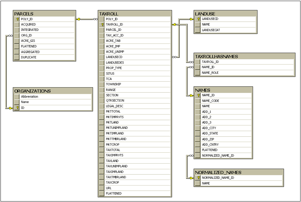
The 2007 Washington State Parcel Database is designed to be flexible and therefore carries with it some additional overhead that demands thoughtful use. The database is designed with three primary components: the Parcels feature class, the TaxRoll table and the Names table. Additionally there is a TaxRollHasNames table which is necessary to handle the many‐to‐many relationships between owners and the taxroll (a single parcel may have multiple owners and a single owner may have multiple parcels). The relationship of the tables can be seen in Figure 9.
Database Design
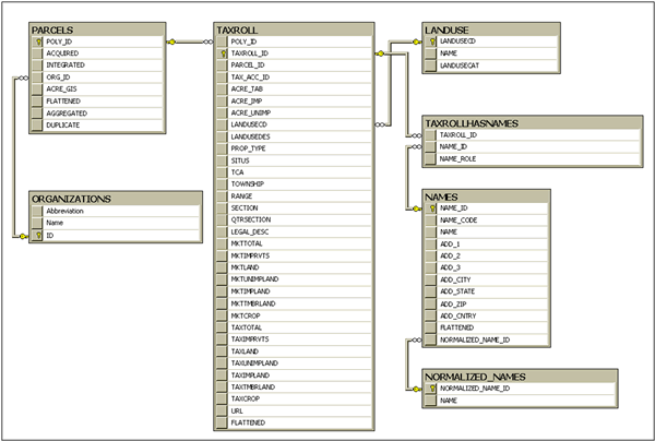 |
| Figure 9: Washington State Parcel Database Entity Relationship Diagram |
Attributes
The name and SQL Server data type are followed by the description. Not all attributes are collected by each data providing organization, and therefore not all attributes are available for all parcels.
Parcels Table
POLY_ID (nvarchar 16): The unique identifier for each parcel created by FME in the data normalization process.
ACQUIRED (datetime): The date the data was acquired from the county or agency.
INTEGRATED (datetime): The date the data was normalized using FME.
ORG_ID (smallint): The unique identification number for each data providing organization. Counties are numbered one through 39, while State and Federal Agencies are 40 and greater.
ACRE_GIS (numeric 38,8): The acreage of each parcel, calculated in the GIS software. It is based on the geometry of the GIS parcels provided by each county.
FLATTENED (smallint): The number of stacked parcels in the original data that were combined to make each parcel in the database. See the section, “Correcting Errors in the Data, QA/QC”, for a discussion of Stacked Parcels.
AGGREGATED (smallint): The number of parcels in the original data that were combined to make each multipart polygon parcel. See the section, “Correcting Errors in the Data, QA/QC”, for a discussion of Multipart Parcels.
DUPLICATE (smallint): The number of duplicate parcels in the original data combined to make each parcel in the database. See the section, “Correcting Errors in the Data, QA/QC”, for a discussion of Duplicate Parcels.

Organizations Table
ABBREVIATION (nvarchar 15): An abbreviation of the organization name.
NAME (nvarchar 100): The name of the organization which developed and is responsible for the data.
ID (smallint): The unique identification number for each data providing organization. Counties are numbered one through 39, while State and Federal Agencies are 40 and greater.
TaxRoll Table
POLY_ID (nvarchar 16): The unique identifier for each parcel created by FME in the data normalization process. Used to relate this table to the Parcels Table.
TAXROLL_ID (nvarchar 16): The unique identifier for each tax roll created by FME in the data normalization process.
PARCEL_ID (nvarchar 50): The unique parcel identification number created by the data providing organization.
TAX_ACC_ID (nvarchar 50): The unique taxpayer identification number for each parcel created by each data providing organization.
ACRE_TAB (numeric 38, 8): The total acreage of each parcel as measured by the data providing organization.
ACRE_IMP (numeric 38, 8): The acreage of improved land on each parcel as measured by the data providing organization.
ACRE_UNIMP (numeric 38, 8): The acreage of unimproved land on each parcel as measured by the data providing organization.
LANDUSECD (smallint): The land use code of each parcel as determined by the Assessor at the data providing organization. The values provided by each organization were normalized to fit the Washington State ‘Standard two‐digit land use code’ values as defined in WAC 458‐53‐30. Values range from 1 to 99.
LANDUSEDES (nvarchar 100): The description of the land use of each parcel as determined by the Assessor at the data providing organization.
PROP_TYPE (nvarchar 100): A general land use classification used differently by each data providing organization, usually including broad categories such as commercial, residential, farm, etc.
SITUS (nvarchar 255): The address of each parcel for legal purposes as produced by the data providing organization.
TCA (nvarchar 50): The tax code area for each parcel as defined in WAC 458‐19‐005: " ‘Tax code area’ means a geographical area made up of a unique mix of one or more taxing districts, which is established for the purpose of properly calculating, collecting, and distributing taxes. Only one tax code area will have the same combination of taxing districts, with limited exceptions.”
TOWNSHIP (nvarchar 10): The Public Land Survey System Township in which the parcel is located.
RANGE (nvarchar 10): The Public Land Survey System Range in which the parcel is located.
SECTION (nvarchar 10): The Public Land Survey System Section in which the parcel is located.
QTRSECTION (nvarchar 10): The Public Land Survey System Quarter Section in which the parcel is located.
LEGAL_DESC (nvarchar 255): The legal description of the property boundaries for each parcel, as produced by the data providing organization.
MKTTOTAL (int): The total market value of each parcel, as determined by the Assessor at the data providing organization.
MKTIMPRVTS (int): The market value of the improvements on each parcel, as determined by the Assessor at the data providing organization.
MKTLAND (int): The market value of the land for each parcel, as determined by the Assessor at the data providing organization.
MKTUNIMPLAND (int): The market value of the unimproved land for each parcel, as determined by the Assessor at the data providing organization.
MKTIMPLAND (int): The market value of the improved land for each parcel, as determined by the Assessor at the data providing organization.
MKTTMBRLAND (int): The market value of the timber land for each parcel, as determined by the Assessor at the data providing organization.
MKTCROP (int): The market value of the crop for each parcel, as determined by the Assessor at the data providing organization.
TAXTOTAL (int): The total taxable value of each parcel, as determined by the Assessor at the data providing organization.
TAXIMPRVTS (int): The taxable value of the improvements on each parcel, as determined by the Assessor at the data providing organization.
TAXLAND (int): The taxable value of the land for each parcel, as determined by the Assessor at the data providing organization.
TAXUNIMPLAND (int): The taxable value of the unimproved land for each parcel, as determined by the Assessor at the data providing organization.
TAXIMPLAND (int): The taxable value of the improved land for each parcel, as determined by the Assessor at the data providing organization.
TAXTMBRLAND (int): The taxable value of the timber land for each parcel, as determined by the Assessor at the data providing organization.
TAXCROP (int): The taxable value of the crop for each parcel, as determined by the Assessor at the data providing organization.
URL (nvarchar 255): The address of the website providing tax information for each parcel.
FLATTENED (smallint): The number of duplicate tax rolls in the original data for each tax roll in the database. Calculated as part of the data normalization process in FME. See the section, “Correcting Errors in the Data, QA/QC”, for a discussion of Flattened Tax Rolls.
Land Use Table
LANDUSECD (smallint): The land use code of each parcel as determined by the Assessor at the data providing organization. The values provided by each organization were normalized to fit the Washington State ‘Standard two‐digit land use code’ values as defined in WAC 458‐53‐30. Values range from 1 to 99. It is a numeric representation of the land use name. Used to relate this table to the Parcels Table.
NAME (nvarchar 100): The name of the land use for each parcel as determined by the Assessor at the data providing organization. The values provided by each organization were normalized to fit the Washington State ‘Standard two‐digit land use code’ values as defined in WAC 458‐53‐30.
LANDUSECAT (nvarchar 44): The land use category of each parcel as determined by the Assessor at the data providing organization. The values provided by each organization were normalized to fit the Washington State ‘Standard two‐digit land use code’ values as defined in WAC 458‐53‐30. There are eight land use categories: residential; manufacturing; transportation, communication, and utilities; trade; services; cultural, entertainment, and recreational; resource production and extraction; undeveloped land and water areas.
TaxRollHasNames Table
TAXROLL_ID (nvarchar 16): The unique identifier for each tax roll created by FME in the data normalization process. Used to relate this table to the Parcels Table.
NAME_ID (nvarchar 16): The unique identifier for each name created by FME in the data normalization process. Used to relate this table to the Names Table.
NAME_ROLE (nvarchar 10): Who the name attributes belong to. Data providing organizations could maintain taxpayer names, owner names, or both.
Names Table
NAME_ID (nvarchar 16): The unique identifier for each name created by FME in the data normalization process.
NAME_CODE (nvarchar 50): Some data providing organizations distribute data with names and parcels in separate tables. The name code is the key relating the original data tables from the data providing organization. It is conceptually the same as the NAME_ID.
NAME (nvarchar 255): The owner or taxpayer’s Name as created by the data providing organization.
ADD_1 (nvarchar 255): The owner or taxpayer’s Address as created by the data providing organization.
ADD_2 (nvarchar 255): The owner or taxpayer’s Address as created by the data providing organization.
ADD_3 (nvarchar 255): The owner or taxpayer’s Address as created by the data providing organization.
ADD_CITY (nvarchar 50): The owner or taxpayer’s City as created by the data providing organization.
ADD_STATE (nvarchar 50): The owner or taxpayer’s State as created by the data providing organization.
ADD_ZIP (nvarchar 50): The owner or taxpayer’s Zip Code as created by the data providing organization.
ACC_CNTRY (nvarchar 50): The owner or taxpayer’s Country as created by the data providing organization.
FLATTENED (smallint): The number of duplicate names in the original data for each name in the database. Calculated as part of the data normalization process in FME. See the section, “Correcting Errors in the Data, QA/QC”, for a discussion of Flattened Names.
NORMALIZED_NAME_ID (int): The unique identifier for each normalized name created by FME in the data normalization process. Used to relate this table to the Normalized Names Table.
NormalizedNames Table
NORMALIZED_NAME_ID (int): The unique identifier for each normalized name created by FME in the data normalization process. Used to relate this table to the Names Table.
NORMALIZED_NAME (nvarchar 255): There are times when the same owner or taxpayer name appears in a County’s data spelled differently. This is a consistent version of each name for identifying ownerships across the state. Due to time and resource constraints this functionality has not been implemented.
|