|
GPS Tools

Save waypoints, tracks and routes in a variety of
formats, including Geographic Lat/Lon shapefiles or UTM
projection shapefiles.
|
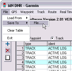
The
Minnesota DNR Garmin Tool 4.0 is a must-have GPS utility
for those using Garmin GPS receivers. As a standalone program:
- Download waypoints, tracks, and routes from Garmin GPS.
Save as text files, ESRI shapefiles or dBase IV files. Capture
GPS screens as graphics.
- Upload waypoints, tracks, and routes to Garmin GPS.
- Perform real-time GPS tracking.
- Convert point shapefiles to GPS waypoints or convert line
and polygon shapefiles to Garmin GPS tracks.
- Convert point themes to lines or polygons.
When used as an ArcView® Extension, DNR Garmin Tool does
even more with theme attributes, measurements, etc. See complete
documentation at the Minnesota DNR site.
Note: Wisconsin DNR also produces a version of the Garmin
Tool that converts Geographic coordinates to and from the
Wisconsin Transverse Mercator (WTM83) system. You can get
the WI DNR Garmin Tool here. Otherwise, use the Minnesota
version for UTM projections.
|
 |
OziExplorer®
allows you to import any photo or map as a background image
for GPS data, including those you make with a flatbed scanner.
The program has an easy method of geo-referencing images. You
simply provide the latitude and longitude of two or more points.
Ozi exports GPS tracks and waypoints as ESRI shape files, making
it possible to use your GPS data in other geospatial mapping
programs like Global Mapper, Map Maker or ArcExplorer. OziExplorerCE
is also available to use with handheld or PDA devices. |
|
GPS Mapping Software
|
OziExplorer automatically positions GeoTIFF files and other
geo-referenced maps or aerial photos. The registered version
of the program also works directly with MrSID format mapping
products and provides more flexibility in specifying map projections
and datums.
|
 |
TopoFusion™
delivers a versatile suite GPS mapping tools. The software connects
to Garmin and Magellan receivers to download or upload tracks
and waypoints. Aerial photos and topographic maps are retrieved
from TerraServer, over which TopoFusion displays GPS tracks
in colored hues indicating elevations of the path (see a TopoFusion
track map and elevation profile here). As shown to the left,
aerial photos and USGS topographic maps can |
|
be blended. Tracks can be averaged, merged or cut apart
and trail networks created. The PhotoFusion™
feature builds interactive pages linking the map and photographs
taken along a path by correlating the time stamps of photos
to those of the track points (an outstanding tool for anyone
who takes a lot of pictures outdoors). TopoFusion will play
back an animation of a trek or ride, displaying trip statistics
such as distances traveled, speed and elevation changes.
Check the TopoFusion site for a complete list of features
and to download
the free trial.
|
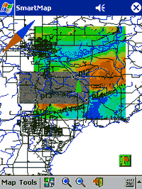 |
Vito
SmartMap freeware is a Windows CE/Pocket PC application
that displays live GPS positions, tracks and routes on detailed,
custom maps or aerial photographs that you can prepare yourself.
The package includes a Windows desktop application called MapManager
that creates base maps from JPG images and Geographic/WGS84
vector shapefiles. The program geo-references scanned maps or
aerial photos to the lat/lon WGS84 coordinate system if you
supply at least three ground control points. You can also make
base maps from Global Mapper screen captures, like the one on
the left, that combine raster and vector data. MapManager optimizes
the maps for use on Pocket PCs, enabling SmartMap to scroll
and zoom maps almost instantly. The free version of SmartMap
is limited to recording 10 waypoints and 500 track points, but
otherwise is identical to the full version. |
| Without a doubt, Vito SmartMap is one of the best GPS mapping
programs you will find for a Pocket PC. By connecting an inexpensive
handheld GPS unit (or a GPS antenna/receiver with no screen
of its own) to an iPAQ or similar PDA, you can have a state-of-the-art
mobile mapping tool. The program is especially useful for resource
managers who might want to navigate a detailed property map
to collect data at pre-determined locations. They can view their
map or aerial photo on the PDA and then switch to their data-entry
program (like Kruzer
or FS Tally Meter) to record the data. "Pushpins"
for each data location can be recorded with SmartMap, which
can then export waypoints and tracks as shapefiles for other
mapping programs. GPS units using an external antenna can be
stowed away and all the map navigation and data recording done
on the PDA. Fabulous for field workers with only two hands!
The full version of Vito SmartMap, selling for only $30,
records unlimited waypoints and tracks. Vito
Technology makes a utility
(free to registered SmartMap users) to download waypoints
from Garmin GPS receivers and convert them to the "pushpin"
format used by SmartMap and a related program called Vito
Navigator. The Navigator program is also quite useful
as a data collection companion, especially for setting up
and following a grid route.
|
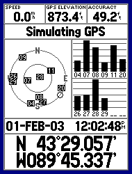 |
G7toWin
and G7toCE are companion programs that manage GPS waypoint,
track and route files on Windows desktop or laptop and handheld
computers. The programs work with Garmin, Magellan and Lowrance
GPS units. The CE version is useful for storing GPS data on
a PDA, especially if you want to save data in the field before
resetting a GPS receiver's memory.
Functions include the ability to convert GPS tracks to routes/waypoints
and a utility to capture the screen image of your GPS unit
(like the Garmin GPSMAP 76S screen to the left) to a desktop
or laptop PC. Waypoints and tracks can be saved or converted
to various formats used by other mapping programs like OziExplorer®,
Delorme Street Atlas USA®, Fugawi®, MapTech® and
others.
|
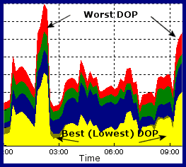 |
Trimble® GPS Planning:
Since GPS satellites move in and out of view as they orbit the
earth, you may need to plan GPS data collection to coincide
with optimal satellite coverage of your work area. Trimble®
offers free GPS
Planning Software that determines the visibility of
NAVSTAR GPS, GLONASS (Russian GPS) and WAAS satellites. The
software includes an almanac that calculates the positions of
satellites on any day over any given location. Position Dilution
of Precision (PDOP/DOP) charts are produced showing the
best/worst times of the day for GPS satellite availability.
See the GPS Page or the
Trimble
Planning Quick Start Guide from the USFS for more information. |
|
|
|
The Rural Technology Home Page is provided by the College of Forest
Resources. For more information, please contact the Rural
Technology Initiative, University of Washington Box 352100 Seattle,
WA 98195, (206) 543-0827. © 2000-2004, University of Washington, Rural
Technology Initiative, including all photographs and images unless otherwise
noted. To view the www.ruraltech.org privacy policy, click
here.
|