| RTI would like to recognize and thank
Paul Pingrey for allowing us to use the content of his website(
Digital Grove). The images and content found below stem directly
from Digital Grove. Click on this link to check out Digital
Grove in its entirety. |
Unsure whether to purchase a GPS unit? See Discovering
GPS, an article originally written for Paul Pingrey's friends
at the Wisconsin Woodland Owners Association. It explains how GPS
works and the differences between recreational grade units.
You might wonder, "Which is the right GPS unit for the
job?" There are three general grades of GPS units: recreational
grade, mapping or resource grade and survey grade. See the GPS
Comparisons below to help choose the right tool for you.
Discovering
GPS
 |
A couple years ago I wanted something different
as a gift for my wife, Karen. She enjoys exploring outdoors
and keeps a journal with the locations of wild flowers she finds
on her walks. I thought she might like a Global Positioning
System (GPS) unit. With a GPS you can record your location to
within a few feet. As it turns out, the Garmin GPS unit is one
of her favorite gifts. Karen memorized the instruction book
and within a day was exploring the backwoods of Devil’s
Lake State Park in southern Wisconsin.
|
|
|
She especially liked the GPS unit because there
are many places she wanted to go where there are no trails.
Now when she starts a walk, she can click the unit and record
where the car is parked. She can also enter coordinates for
points she wants to travel to. |
 |
As she hikes in the woods, the GPS unit keeps track of where
she is in relation to any of the points she’s interested
in. The unit will tell her if:
- she’s going in the right direction
- how far away the point of interest is
- how fast she is moving toward it
- All that information is displayed on a screen that fits
in the palm of her hand.
All that information is displayed on a screen that fits in
the palm of her hand.
|
 |
So how does GPS work? The US Air Force maintains
a "constellation" of at least twenty-four GPS satellites
that orbit the earth. The satellites are like the stars that
people have navigated with for ages. The only difference is
that the GPS "stars" send out radio transmissions
that an antenna in your GPS unit picks up. If the GPS unit can
get a signal from at least three satellites, it will calculate
where it is by using an internal clock and simple geometry.
Since the unit’s clock isn’t perfect and the satellites
are moving (among other reasons), there is error in the location
estimate. An error of one billionth of a second in the clock
translates into about a one-foot error on the ground. The more
satellites a GPS unit gets a signal from, the smaller that error
is likely to be. A unit with a differential correction feature
called "WAAS" (explained
below) can be accurate to within about 10-16 feet
on a fairly consistent basis. |
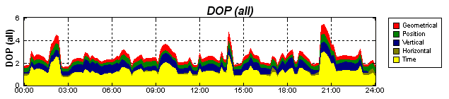
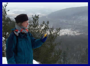
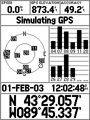
To check her GPS unit’s accuracy, Karen switchesscreens (by
clicking a button), and it shows her how many satellites it can
"see" and what the estimated precision error is at that
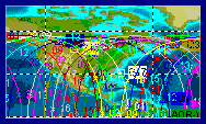
moment. The location of each satellite in relation to the others
and their geometry relative to the GPS unit affects the Dilution
of Precision (DOP). DOP values change through the day as the
satellites move in and out of view as shown in the above sample
chart for a specific day/location. The graph was produced by Trimble's
GPS Planning Software described below. The lower the
DOP value, the better your GPS location calculation is likely to
be. Dense tree foliage, obstructions like hills and buildings
or holding the GPS unit too close to your body can also block signals
and reduce accuracy.
Although Karen's GPS seldom shows an estimated error
greater than 60 feet, she is realistic about her unit’s accuracy.
She wouldn’t pretend to be a surveyor with it. If she were
looking for a section corner, den tree, deer stand, patch of flowers
or our parked car, though, she can come relatively close.
 |
The main difference between recreational
grade GPS units is whether or not they display a base map. The
less expensive units like Karen's basic eTrex costing about
$100 have no built-in maps but are still very handy. They keep
track of where you go with a dotted line on the screen. The
screen will also show waypoints, which are ground locations
that you click on as you travel or which you enter in advance
as latitude/longitude coordinates. More advanced units costing
$200 to $500 have built-in maps showing roads and streets. Some
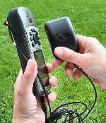
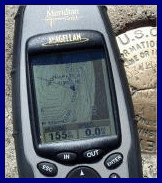
units (like my Magellan on the left) display topographic elevation
lines that are downloaded from companion CDs such as Magellan's
MapSend or Garmin's MapSource products. |
If you are looking for a GPS unit, get one with the Wide Area Augmentation
System (WAAS) feature. WAAS GPS units track a couple extra geostationary
satellites that send out correction signals, enabling accuracy to
around 10 to 16 feet under ideal conditions. (See more information
below.) Garmin,
Magellan
and Lowrance
are some of the more popular GPS brands featuring WAAS.
 |
The Garmin GPS76S unit (purchased for about $360
from Amazon) has built-in maps and a larger display like the
Magellan. It also includes an electronic compass (which works
with the unit held horizontally) and a built-in barometric altimeter
to improve the accuracy of elevation readings. |
The GPS76S is a great unit, but the extras do shorten battery life.
Karen's little Garmin eTrex is good for a couple days of hiking, rated
at about 20 hours on two rechargeable AA batteries. My Magellan Meridian
Gold unit is rated at 14 hours and hasn't had any trouble lasting
an eight-hour field day. (The only complaint I have about the Magellan
is that the power button sticks out too far, frequently causing the
unit to be unintentionally turned off.) The Garmin GPS76S is rated
at 10 hours with 2 AA batteries, however it might not last three hours
on some cold winter days. All the bells and whistles cause a power
drain, meaning you better have more batteries in your pocket.
If you don't really need the extra features like an electronic
compass and altimeter, the longer battery life found in simpler
units could more than outweigh the prestige of having a top-of-the-line
unit. You would also be wise to carry a conventional magnetic compass
and not rely entirely on your GPS unit in field situations.
If you want to get the most out of a GPS unit, use it with a
computer-mapping program. USA
PhotoMaps and OziExplorer
for 2D maps or 3DEM for
3D views are available for free download from the Internet. Delorme's
Topo USA, which costs about $100, is another excellent program
to use with your GPS Unit. The programs communicate with the GPS
unit via a cable that connects it to the computer. They download
the tracks and waypoints from the GPS unit and draw them on a map.
|
|
|
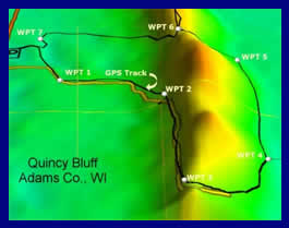
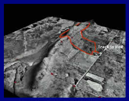
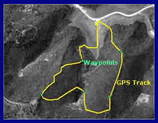
| The images above show the track of a hike at Wisconsin's
Quincy Bluff, a 200-foot high sandstone ridge surrounded by
flat lowlands. To help the ridge stand out, a 250% vertical
exaggeration was applied in 3DEM. |
GPS
Comparisons
What are the limitations of a recreational grade GPS unit? Do you
need more precision? The following
table explains the basic differences between recreational
grade and mapping grade GPS units.
Note that both recreational grade GPS (depending upon the features
of a particular unit) and mapping grade GPS are capable of real-time
differential corrections. Differential GPS (DGPS) significantly
improves accuracy, potentially reducing real-time error to less
than 3 to 5 meters (<10 to 16 feet). The basic concept is that
coordinates provided by the NAVSTAR GPS satellites are compared
to readings at fixed locations. The differences between the NAVSTAR
GPS readings and the known locations are used to calculate corrections
that are applied to your GPS unit's location display.
There are two types of real-time differential corrections available
for recreational grade GPS:
- Corrections based on signals from geostationary Wide
Area Augmentation System (WAAS) satellites (broadcasting
corrections from about twenty-five US North American ground stations
...more to be added in 2003). Currently, only two WAAS relay satellites
are generally visible from the US. The satellites are positioned
over the equator. You need a good view of the southern sky to
receive the signals. Since the reception angle is extreme, tree
cover, hills or other obstructions including buildings or even
your body can block WAAS signals. Eventually there could be as
many as 19 WAAS relay satellites, making WAAS a dependable DGPS
system, but deployment will be slow in coming. For a WAAS tutorial
and additional links to coverage maps, see gpsinformation.net.
(WAAS correction is not yet available outside North America but
related European and Pacific systems are being developed.)
- Corrections based on signals from US
Coast Guard (USCG) Differential
Beacon Receiver Transmitters located throughout the USA. You
must be in range of a USCG transmitter to use the system. Maps
of USCG transmitter coverage are available at the above link.
(Other differential base station systems are also employed elsewhere
in the world.)
Recreational grade units sold in the US typically use the WAAS
system. Some recreational grade units can take advantage of USCG
differential correction with an optional beacon receiver (e.g.,
the Garmin GBR
23 receiver, which can be configured to operate
from a backpack). Mapping grade units might be designed to use
WAAS, USCG or other reference station signals. They also save coordinate
data in a format that can be used in post-processing correction
programs, potentially resulting in sub-meter accuracy.
Survey grade GPS is not included in the table. Survey grade
units are used where accuracy is crucial (as in cadastral surveys,
highway construction and other engineering projects). They are capable
of providing horizontal accuracy to within a centimeter. The costs
(up to $40,000), training requirements, time involved to establish
readings and other factors make survey grade instruments impractical
for general resource management applications.
|
|
|
Recreational Grade
|
Mapping/Resource Grade
|
|
Primary Uses (Including
Forestry Applications)
|
- General navigation (including real-time moving maps),
outdoor sports, hiking, geocaching, etc. See other GPS uses
here.
- Collection of point data. Note: You will get better results
if you pause 10-15 seconds or longer to assess GPS signal
strength before recording waypoints. (Precision DGPS requires
10-15 minutes minimum at a static location for adequate
satellite data acquisition and averaging.) Some receivers
are 2-3 times more accurate in a vertical rather than horizontal
orientation when collecting point data.
- General forest reconnaissance using manual inventory methods
- Estimating acreage of forest stands/areas, although
potential errors for small areas or areas with complex boundaries
may be unacceptable. See the European Commission "Note
on the use of stand-alone GPS for parcel measurement"
or "Estimate
of Area Calculation Error Using Handheld GPS" for
discussions on the topic.
- Relocating individual trees, a group of plants, a nest,
etc. if the spot is flagged in some way so it can be seen
when you get close
|
- Resource mapping and navigation
- Collection of lines/roads and areas/stands in addition
to point data. Associate GIS data collected on-site to the
map objects.
- Forest reconnaissance using digital data recorders
- Measurement of areas to a higher level of precision (when
used with differential correction) than possible with recreational
grade units
- Relocating individual trees, a group of plants, a nest
or other local features that are not otherwise flagged
Note: You may need to plan GPS data collection
to coincide with optimal NAVSTAR GPS, GLONASS (Russian GPS)
or other satellite availability over your work area. Trimble
offers free GPS planning software that determines the
visibility of GPS satellites.
|
|
Horizontal Data Accuracy
(Based on Manufactures' Literature)
|
- Typically <15 meters (49 feet) with no differential
correction. Error greater under conditions such as dense
tree foliage, steep terrain or poor satellite orientation.
- 3 to 5 m (or 10' to 16') with WAAS real-time correction.
Recreational GPS units have no post processing correction
capability.
|
- Typically <15 meters (49 feet) with no differential
correction. Error greater under conditions such as dense
tree foliage, steep terrain or poor satellite orientation.
- 1 to 5 m accuracy in real-time or <50 cm accuracy with
post-processing correction using base station differential
corrections
|
|
Vertical Data Accuracy
|
- Not generally relied upon to collect vertical data, although
more expensive units might include a barometric altimeter
that manufactures claim to have ~10 foot accuracy.
|
- Manufactures' literature warns that vertical positional
error is likely to be two to three times greater than horizontal
error (mainly because there are no satellites under you
to use for triangulation)
|
|
Differential Correction Options
|
- No post-processing capabilities
- Many receivers offer real-time correction (WAAS or USCG)
|
- Post-processing for accuracy potentially better than 50
cm horizontal location
- Some receivers offer real-time subscription-based correction
in addition to integrated WAAS or USCG systems
|
|
Data Points Stored in GPS Unit
|
- Typically 500 waypoints. Tracklog point capacity will
generally vary between 1,000 and 5,000 records.
 For more data
storage, you could transfer GPS data to a PDA. Freeware programs
such as GPilotS
are available for PalmOS handhelds or G7toCE
for Pocket PCs that download and manage waypoint, track and
route data. G7toWin
manages waypoint, track and route records on a desktop PC. For more data
storage, you could transfer GPS data to a PDA. Freeware programs
such as GPilotS
are available for PalmOS handhelds or G7toCE
for Pocket PCs that download and manage waypoint, track and
route data. G7toWin
manages waypoint, track and route records on a desktop PC.
Note: If you need an inexpensive serial cable to connect
a GPS unit to the current line of iPAQ PDAs ? including the
iPAQ h1910, 3800 and 3900 models ? you can get them at SupplyNet
or eXpansys.
|
- Up to 50,000+ records, depending on model
 Use G7toWin to capture GPS unit screens or
to store GPS data from Garmin, Magellan or Lowrance receivers.
Use G7toWin to capture GPS unit screens or
to store GPS data from Garmin, Magellan or Lowrance receivers. |
|
Ease of Use
|
|
|
|
|
Cost
|
|
|
|
|
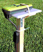
External Antennas
|
| To get good GPS signals with a handheld
unit, the receiver's antenna must be oriented correctly. Units
like the Garmin eTrex and Geko with a patch antenna work best
held horizontally so the face of the unit looks up at the sky.
Others with a quad-helix type antenna (like the Garmin 72/76
series or the Magellan Meridian) work best with the top edge
pointed skyward.
Trying to maintain an ideal antenna orientation can be annoying
if you are carrying a GPS, especially while hiking or doing
other field work. An external antenna is a perfect solution
if your unit accepts one. Here are a few options:
|
|
- Small, light antennas like a low-profile Garmin
27C (left, a thin black box small as half a deck of
cards, costing about $70) can be attached to your
hat or to the top of a pole on a backpack or vest.
Such units draw very little power from a GPS unit
but can boost signal strength. With an external antenna
attached, you can put the GPS unit out of the way
inside your coat or in a pocket (a convenient way
to maintain battery performance in very cold weather).
|
|
|
- Larger dome antennas can be mounted on a pole-equipped
backpack. The Garmin 17N has the GPS receiver
built into the dome and is popular for use with field
data recorders or Windows CE devices to collect information
in the field.
|
|
|
- Simply mount your handheld GPS in the proper orientation
on a pole attached to a backpack or vest. (The lightweight,
waterproof Geko 201 works well as an external antenna
for field work.) Connect the GPS with a cable to a
Palm or Pocket PC and use software on the PDA to view
maps and record locations. Bluetooth GPS units that
communicate with PDAs without the use of any cables
are also available.
|
|
|
External Power Supply
|
 |
Any GPS unit or other electronic device
with a power supply cable that connects to a 12-volt
cigarette lighter outlet can be operated with a portable
battery in the field. 12-volt power supplies are relatively
inexpensive ($30
to $80) but heavy (three to seven pounds). They are
often sold in carrying cases, complete with AC and DC
recharging systems. If you are running multiple tools
(such as external antennas, data collectors and cellular
phones), you might want a power supply with multiple
ports. CycoActive
also offers a light-weight C-cell battery pack for eTrex
and Geko GPS units. |
|
|
Comments
|
- Recreational grade units are a good companion alongside
a clipboard, paper and pencil for field work. Write down
waypoint numbers for manual data plots and review your GPS
track as you proceed or later in the office.
- Transfer waypoints or tracks (based on property corners
or boundary lines) from an aerial photo to the GPS unit
to use as references when traversing a parcel of land.
- Recreational grade GPS units work well with a variety
of field data recorders, including relatively inexpensive
Pocket PC devices like the iPAQ or ruggedized units like
the Juniper Allegro®.
|
|
More Information
|
|
|
|
| Does the new GPS technology mean
that resource managers are likely to abandon their compasses
and stop pacing to measure the distance they've covered? Maybe.
Many will find that the most efficient way to move quickly
across the countryside is still by sighting through a compass
notch and counting steps. If you've done much fieldwork, though,
you know that after making a few offsets to get around bramble
patches, cliffs or sinkholes and swatting mosquitoes (losing
your pace count), your precise location can get ...well, a
little hazy. In those situations, a GPS location fix can help
you get back or stay on course.
For other resource managers, GPS combined with the use of
handheld data recorders will revolutionize field inventory
procedures. The new tools allow foresters, for example, to
see real time maps of where they are in the woods. Sampling
grids can be overlain on maps, with GPS guiding foresters
to each sample plot location. The resulting data can be more
accurate and processed in record time compared to traditional
navigation and manual data entry.
The grade of GPS unit you select depends on the type of field
work or data collection involved. In many instances (including
most forest inventory tasks), a recreational grade unit may
be entirely adequate. If a forester were setting up a timber
harvest, however, that's a different situation. When a couple
dozen trees get cut across the neighbor's property line because
of a mere 66-foot GPS error, the neighbor is likely to be
hopping mad! Better use a resource/mapping grade GPS if you
are relying on the instrument for boundary location or research
where location and area calculations are critical.
|
|