The Rural Technology Initiative ceased operations in 2011. This site is maintained as an archive of works from RTI collaborators from 2000 to 2011 and is no longer updated. RTI's successor and remaining staff can be found at NRSIG.org


Search the RTI Website
 
Click to go to the Precision Forestry Cooperative website
Click to go to the RTI Home page
Click to go to the About RTI page
Click to go to the RTI Projects page
Click to go to the RTI Publications page
Click to go to the RTI Tools page
Click to go to the RTI Geographic Information Systems page
Click to go to the RTI Streaming Video Directory
Click to go to the RTI Training page
Click to go to the RTI Contacts page
Click to go to the RTI Image Archive
Click to go to the RTI Site Map
Click to go to the RTI Links page


How to use the LMS Analyst Extension: Zonal Mean Analyst


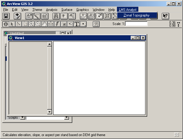
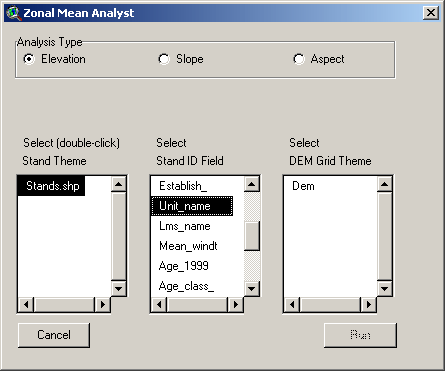
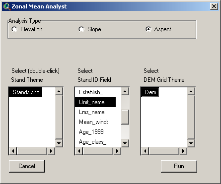
The Zonal Mean Analyst

The Zonal Mean Analyst calculates elevation, slope, and aspect statistics on a polygon-by-polygon basis.

Make sure you have loaded and enabled the LMS Analyst Extension.

From the View GUI's LMS Analyst menu, select Zonal Topography.


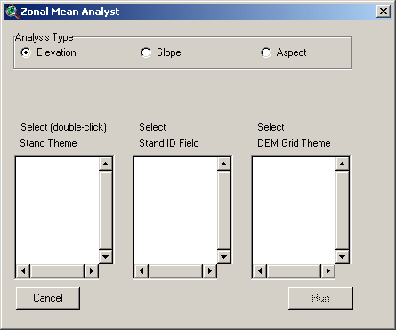
The Zonal Mean Analyst dialog will open. When the dialog opens, you may or not see data loaded into any of the selection controls.


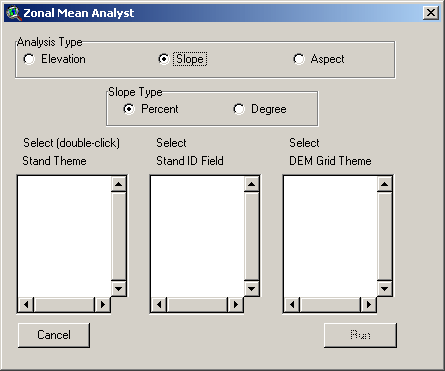
Select the type of analysis you want to perform by clicking the appropriate Analysis Type radio button. Note that when you select the Slope radio button, you will get a choice between Percent and Degree.


If you have polygon or grid data themes in your View, these will automatically show up in the Select Stand Theme and Select DEM Grid Theme selection controls.


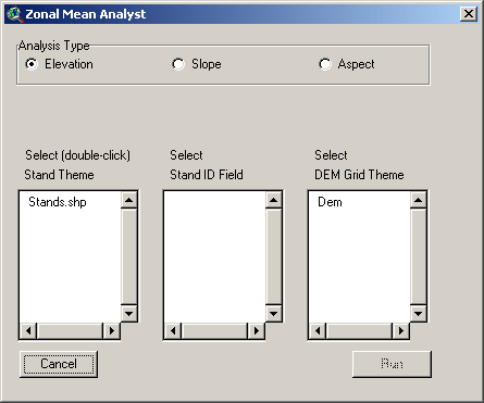
Select the Stand Theme by double-clicking on the desired theme name. When you do, the Select Stand ID Field control will populate with the fields from the Stand theme's attribute table.


Select the field that uniquely identifies each polygon.

Also select the Grid theme that represents elevation data. When you do, the Run button will become enabled.


Click the Run button and the appropriate analysis will run.

After the process completes, you will have at least one new field added to the Stand theme table. These are the possibilities of new fields, based on the type of analysis:

Analysis Type
Field(s) Added
Elevation Elev_mean, Elev_min, Elev_max
Slope (Percent) Slp_p_mean, Slp_p_min, Slp_p_max
Slope (Degree) Slp_d_mean, Slp_d_min, Slp_d_max
Aspect Asp_mean

Landscape Mangement System Home Page


Phil Hurvitz, GIS Specialist
phurvitz@u.washington.edu
 
School of Environmental and Forest Sciences
USDA Forest Service State & Private Forestry
WSU Cooperative Extension
The Rural Technology Home Page is provided by the College of Forest Resources. For more information, please contact the Rural Technology Initiative, University of Washington Box 352100 Seattle, WA 98195, (206) 543-0827. © 2000-2004, University of Washington, Rural Technology Initiative, including all photographs and images unless otherwise noted. To view the www.ruraltech.org privacy policy, click here.
Last Updated 10/13/2022 12:35:25 PM