An overview of CULSED
Forest roads are at the core of modern forestry, and are also responsible
for generating and delivering sediment to stream networks. Sediment
production is a function of a multitude of factors, among which:
road grade, road length, road age, surface material and condition,
cut slopes, local climate, soil and parent material all contribute.
The current most used solution for reducing sediment delivery is
the cross drain systems. CULSED is a GIS decision support tool that
works by taking all the factors that lead to sediment delivery into
streams, and using those parameters to optimize culvert placement
to lessen the impact of roads.
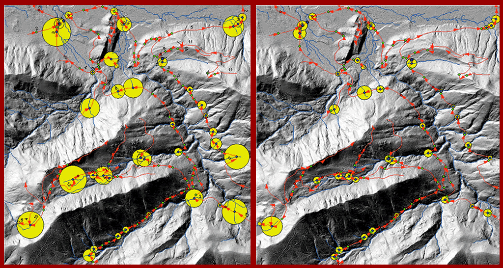
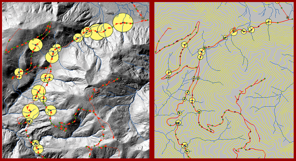
Here is a comparative study done on the Reese Creek Watershed,
a central part of the North Tahoma State Forest. This site was chosen
for our cross drain design experiment due to its fragmented terrain
with many streams and road-stream crossings. A sufficient amount
of site descriptive information was available. Digital datasets
of existing cross drains, roads and high resolution digital elevation
models were obtained from WA DNR.
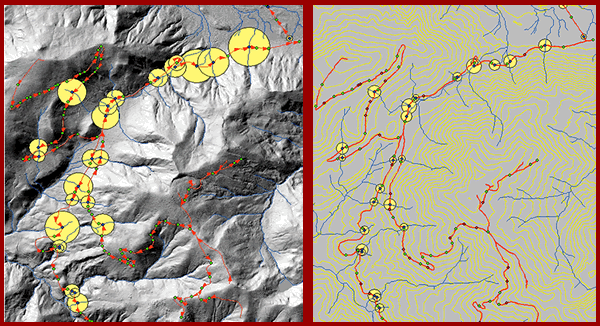
In the CULSED model, a number of culverts were relocated to key
locations in order to achieve sediment reduction for the entire
North Tahoma project area. Comparing the relative size of the proportional
symbols with the original configuration (in both sets of images
below), the sediment reduction becomes obvious.
|
Initial sedimentation from
East North Tahoma road network - 42.10
tons/yr |
Sediment delivery from East
North Tahoma road network after redesigning the cross drain
system - 13.12 tons/ year |
|
For both images: blue dots represent stream
crossings; red dots represent cross drains at natural draws
and wet spots; green dots represent other cross drains; red
arrows indicate direction of sediment flow along roadside
ditch; the numbers represent road grade.
*Yellow circles are proportional with sedimentation
at the respective location;
69% sedimentation reduction from
the original design. |
| Initial sedimentation from West
North Tahoma road network - 25.18
tons/yr |
Sediment delivery from West
North Tahoma road network after redesigning the cross drain
system - 7.83 tons/yr |
|
For both images: blue dots represent stream
crossings; red dots represent cross drains at natural draws
and wet spots; green dots represent other cross drains; red
arrows indicate direction of sediment flow along roadside
ditch; the numbers represent road grade.
*Yellow circles are proportional to the
sediment delivered at the respective locations; 68
% sedimentation reduction from the original design. |
A major sediment model improvement that CULSED has made is its
instantaneous feedback. It makes an immediate evaluation of a user
action (adding, moving or removing culverts), and returns that evaluation
to the user in a easily comprehensible form. The instantaneous feedback
is important because it gives users the ability to quickly judge
their own design decisions and improve them.
We do not currently have funding to maintain or support CULSED software. However we are always looking for opportunities to upgrade and maintain currency with the ArcGIS platform. If you have a project that could benefit from a newer version of CULSED please feel free to contact Luke (lwrogers u.washington.edu). u.washington.edu). |
Download CULSED for ArcGIS
|