The Rural Technology Initiative ceased operations in 2011. This site is maintained as an archive of works from RTI collaborators from 2000 to 2011 and is no longer updated. RTI's successor and remaining staff can be found at NRSIG.org


Search the RTI Website
 
Click to go to the Precision Forestry Cooperative website
Click to go to the RTI Home page
Click to go to the About RTI page
Click to go to the RTI Projects page
Click to go to the RTI Publications page
Click to go to the RTI Tools page
Click to go to the RTI Geographic Information Systems page
Click to go to the RTI Streaming Video Directory
Click to go to the RTI Training page
Click to go to the RTI Contacts page
Click to go to the RTI Image Archive
Click to go to the RTI Site Map
Click to go to the RTI Links page


CULSED: Instalation Instructions


How to Install CULSED

CULSED is an application that runs within ArcMap 8.2. It is comprised of two ArcMap extensions currently named RoadSedimentAnalyst and RSASedimentModel. They will show up in the tools/extensions menu item of ArcMap. The CULSED toolbar provided with the program will show up in the ArcMap list of tool upon successful installation.

To install follow the steps below:

  1. Download the RoadSedimentAnalyst.dll and RSASedimentModel.dll to a permanent directory on your computer.
  2. Use the regsvr32 application generally found at \WINNT\system32\regsvr32.exe to register these dll libraries with the operating system. You can do that by dragging the libraries onto a regsvr32 icon on your desktop.
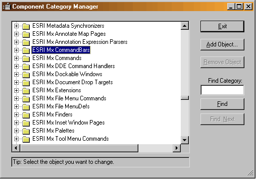
  3. Run the ESRI program called Component Category Manager. It can be found at \arcgis\arcexe82\Bin\categories.exe. A screen capture of this program is given below


  4. Highlight ESRI MX Extensions. Click "Add Object" and select the RSASedimentModel.dll from the directory where you downloaded it and click "OPEN". Select RSASedimentModel and click "OK". This will register the RSASedimentModel extension with ArcMap.
  5. Similarly to step 4, register clsExt from RoadSedimentAnalyst.dll with ESRI MX Extension. Do not register any other objects here.
  6. Under ESRI MX CommandBars category in the Component Category Manager register clsMenu and clsToolBar from the RoadSedimentAnalyst.dll. Do not register any other objects here.
  7. Register all remaining objects (except clsExt, clsMenu and clsToolBar) from RoadSedimentAnalyst.dll with the ESRI MX Commands category.
  8. Start ArcMap and verify that the two extensions were added and the CULSED toolbar is available. If so you are ready to use the program.
 
School of Environmental and Forest Sciences
USDA Forest Service State & Private Forestry
WSU Cooperative Extension
The Rural Technology Home Page is provided by the College of Forest Resources. For more information, please contact the Rural Technology Initiative, University of Washington Box 352100 Seattle, WA 98195, (206) 543-0827. © 2000-2004, University of Washington, Rural Technology Initiative, including all photographs and images unless otherwise noted. To view the www.ruraltech.org privacy policy, click here.
Last Updated 10/13/2022 12:35:18 PM