|
 |
 |
 |


Generating Stream Maps Using LiDAR Derived
Digital Elevation Models and 10-m USGS DEM
|
Adam Mouton
University of Washington 2005 Program Authorized to Offer Degree: ACKNOWLEDGEMENTSI am grateful to Peter Schiess for giving me the opportunity to take on this project and work through it as desired and Finn Krogstad for his ability to handle a bombardment of questions. Thank you to David Montgomery and Steven Burges for advising me on the ways of hydrology and then some; Luke Rogers and Phil Hurvitz for early GIS advice; Hans-Erik Andersen for LiDAR pre-processing; Bob McGaughey for various advice; David Tarboton and Theodore Endreny for question regarding resolution and modeling; and Julie Forcier for grammatical help. Capstone 2005 which is composed of Adam Baines, Lou Beck, Ben Carlson, Mark Williams, Sara Wilson, Edwin Wong, and Amy Hawk for there assistance during field collection. The Washington State DNR provided the financial support for this study.
ABSTRACTThe effects of digital elevation model (DEM) grid size for stream network predictions in the northwestern United States were examined to test the accuracy of high-resolution LiDAR (Light Detection And Ranging) digital elevation data. LiDAR elevation data were gridded at 2-, 6-, and 10-m scales and flow paths were predicted by four common routing algorithms known as D8, D-Infinity, Multiple Flow, and DEMON, D8 being the least sophisticated. These routing algorithms were also applied to a 10-m USGS DEM to compare LiDAR with the previously used data for hydrologic modeling. The analyses indicated that as topographic detail increased, all LiDAR-derived models delineated more streams and located streams in their topographically correct position when compared to a 10-m USGS DEM. Stream maps generated by either D8 or DEMON converged as the DEM resolution was increased. The data suggests that increased DEM resolution decreases the need for sophisticated models, reducing processing times required to create accurate stream locations and attributes. LiDAR digital elevation data also improved the modeling of perennial stream heads and fish habitat potential in a direct comparison to a 10-m USGS DEM. Distances between stream heads predicted using a LiDAR dataset and field verified stream heads were significantly less than those predicted using a USGS dataset. This illustrates the potential use of LiDAR to accurately predict perennial flow in a given landscape. The ability to locate fish barriers based on landscape gradient also improved with LiDAR data. A USGS dataset used to find fish barriers occasionally found barriers in places where none existed or vice versa. As LiDAR datasets become more available, automated creation of stream networks and their hydrologic features will become more feasible and the accuracy of the results will be much improved. TABLE OF CONTENTS
LIST OF FIGURES
LIST OF TABLES
1. INTRODUCTION1.1 Overview However, new mapping technology provides the potential of developing improved stream data from more detailed surface topology. LiDAR (Light Detection And Ranging) data which creates sub meter topography maps (Appendix A) is one technology that promises to provide increased resolution in digital surface detail compared with the typical 10 meter topographic maps and could lead to more precise and accurate maps of stream networks. Preliminary analyses showed that using LiDAR data located more actual stream channels and placed streams in their topographically correct position (Schiess and Tryall, 2002). This ability to generate accurate stream locations and physical attributes using LiDAR will allow long-term sustainable harvest volume calculations to be more reliable. In order to properly map the physical extent of channels in
a watershed, the difference between processes on hillslopes
and in channels must be determined (Tarboton 2003). This difference
becomes apparent when calculating how water collects on a landscape
in a given dataset with flow direction of the water known.
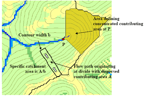
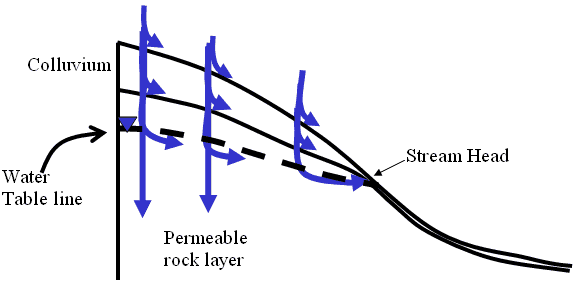
LiDAR can place these physical attributes in their topographically correct position. However, locating point ‘P’ (Figure 1), the perennial initiation point (PIP), becomes a challenge due to it being dependent on the catchment area which fluctuates based on geology, climate, precipitation, and other attributes.
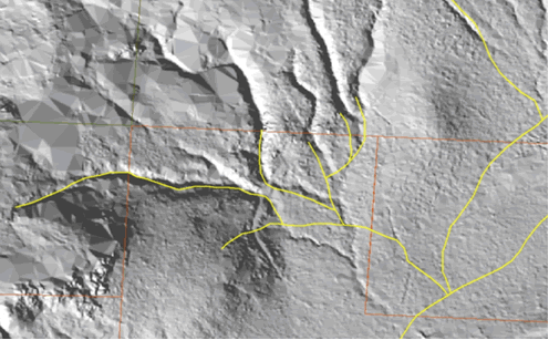
1.2 Previous Studies and Background Review Figure 2 demonstrates topographic error in the Washington DNR stream layer, in yellow, not extending completely up the channel. Overlaid is a 2m LiDAR-derived hillshade model that depicts the presumably correct stream courses. The DNR stream is also shifted by 300 feet to the east of the channel (Schiess and Tryall, 2002). Such discrepancies are not uncommon. This example illustrates possible inaccuracies when stream locations are determined using 7.5-minute topomaps, orthophotos, and some field verification. This was demonstrated in other projects as well and usually is recognized by field staff and planning staff as a critical issue in developing reliable forest operations designs.
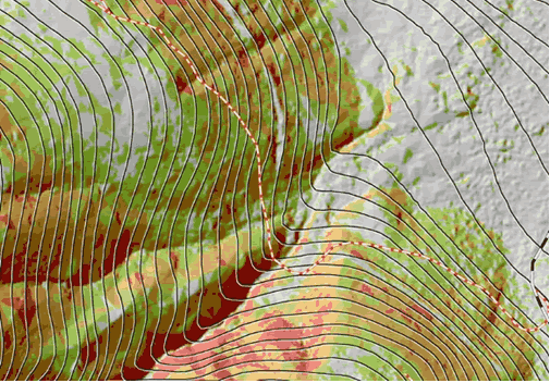
Figure 3 shows the contours generated from a standard 10-m DEM overlaid on a 2m LiDAR-derived hillshade model with slope classes from the LiDAR derived DEM. Downhill is toward the upper right. LiDAR topography provided a realistic and detailed topography. Photogrammetricly produced contour lines captured the general shape of the landscape; however, complex features such as incised streams, draws, abandoned road beds and sharp ridges were not recognized (Schiess and Krogstad, 2003). The contour lines also do not follow the stream channel accurately.
The advantage of LiDAR digital data over conventional photogrammetry is improved mapping in obscured areas. A LiDAR bare ground surface model containing only elevations can be obtained after filtering out the trees and buildings in the dataset. The digital data then can be used in a variety of ways including: digital terrain model for use in generating contours, 3D terrain views, fault locations, steep slopes, critical areas, and stream and drainage basin delineation (North Carolina 2003).
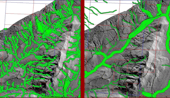
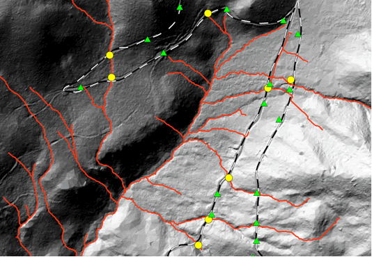
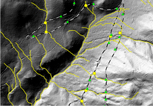
One attempt to use LiDAR data to generate stream channels at the College of Forest Resources, University of Washington was on the South Tyee Planning Study in 2002 (Schiess and Tryall, 2002). The stream layer was produced by the “flowaccumulation” command in GRID and a uniform buffer was added (Figure 4). The stream layer could be adjusted by changing the contributing cells to the stream, which made it possible to duplicate conditions observed in the field. The contributing cell size was adjusted to a slightly higher level in order to include areas that may not have contained water at the time. It should be noted that while the GIS method of “flowaccumulation” puts streams in their expected channels, it can both over- and underestimate the stream lengths (Schiess and Tryall, 2002). This is because a uniform catchment size is defined on all stream basins when catchment size could vary from basin to basin which causes inaccuracy.
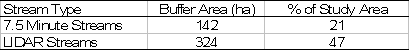
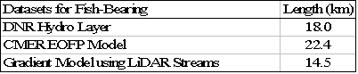
There were many discrepancies in comparing the LiDAR “flowaccumulation” streams with a DNR-Hydro layer, which is based partly on a 7.5 minute topographic generated streams in the South Tyee Planning Study (Schiess and Tryall, 2002). The 7.5 minute streams were buffered with widths based on stream type and the LiDAR streams were buffered at an average of 23m. Table 1 shows that there is a 182-ha difference between the two buffer representations. No thorough field verification was conducted, however.
With better field reconnaissance and appropriate buffer widths a more accurate stream layer could be produced. However, the LiDAR stream data provided a better input for the preliminary planning process than the 7.5 minute stream data (Schiess and Tryall, 2002).
1.3 Current Stream Data
The physical attributes for the Water Typing model were based on a USGS 10-DEM. Using this DEM, physical barriers such as waterfalls and downstream gradient could be overlooked due to the low resolution. Furthermore stream channels predicted using aerial photos under and over estimate stream locations due to visibility. At times, the channels were topographically off from the actual location of those channels (Schiess and Tryall, 2002). The current DNR hydro layer has two coding systems, type code and fish/non-fish code. Type code is describes as:
Types 1-4 are considered perennial and type 5 and 9 are seasonal. The second code either describes streams as fish-bearing or non-fish bearing waters. This code was derived from the Cooperative Monitoring, Evaluation, and Research group (CMER) using the CMER Model as described in the Method / Model Development section. The same channel network is used for both code systems. 1.4 Research Objectives
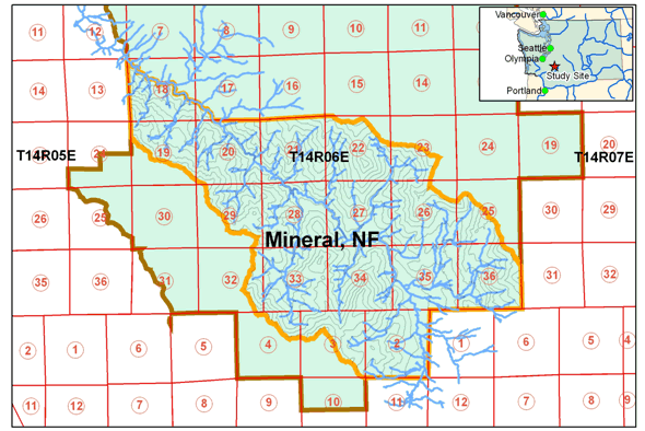
To verify that the increased LiDAR resolution improves stream modeling, different hydrologic models were tested using a 10 meter USGS and several LiDAR DEMs at various resolutions. D8, D-Infinity, Multiple Flow, and DEMON were the model algorithms used (refer to section 2.5 Flow Direction Methods Utilized). Once the models were used and data was generated from the model, field verification was carried out to verify the accuracy of the predicted stream channels. 2. METHODS / MODEL DEVELOPMENTFlow direction algorithms for locating stream channels were used on various resolutions and correlated with field data. This was completed to establish which flow direction technique worked best with LiDAR data. For stream typing, the Cooperative Monitoring, Evaluation, and Research group (CMER) from the Washington State Department of Natural Resources (DNR) has established a model which predicts which streams are inhabited by fish and which do not contain fish. This model was compared to a gradient model approach which used a LiDAR DEM. Three models needed to be developed in order to decide if resolution has an effect on stream channel determinations and if stream types could be determined more accurately by LiDAR. The first model is the generation of the stream network from LiDAR DEM. The second is a water-typing model to determine the end of fish point (EOFP) from the generated stream network and the third is the perennial initiation point (PIP) model. 2.1 Site Description
The mean annual rainfall in this area ranges from 2007 to 2210 mm (Daly et al. 2000) with an altitude range of 500 to 1600 m. Forest cover is dominated by Douglas Fir (Pseudotsuga menziesii) with Western Larch (Larix occidentalis), Red Alder (Alnus rubra), Big Leaf Maple (Acer macrophyllum), Western Hemlock (Tsuga heterophylla), White Fir (Abies concolor), and Black Cottonwood (Populus trichocarpa) throughout. The majority of the region’s soils belong to the Bellicum, Cattcreek, and Cotteral soil series (Soil Survey Staff, 1998). The upper part of the profile has a cindery texture from the pumice and volcanic ash aerially deposited from Mt. St. Helens. The lower part of the profile formed in colluvium, alluvium or glacial till from andesite with a mixture of pumice and volcanic ash. In general, these soils have low fertility and water-holding capacity and often occur on unstable slopes. The geology is categorized by Oligocene-Eocene (OEvba) and Oligocene (Ovc(oh)) defined as basaltic andesite flows and volcaniclastic deposits or rocks. 2.2 Stream Model 2.3 Water-Typing Models 2.3.1 CMER Model
The fish absent | fish present (FAFP) data used to estimate the logistic regression models were generated from 4,052 end-of-fish points (EOFP) placed on a Washington Dept. of Natural Resources (DNR) GIS hydrologic layer. Each EOFP was based on a field survey which followed specific protocols to identify a location on the stream that was designated as either last fish or last fish habitat. Potential EOFP were submitted to DNR for error checking and initial screening (Conrad et al., 2003). After approval by DNR, the EOFP was transferred from the DNR hydrologic layer to a 10m DEM-generated stream point network. An automated procedure was then used to classify points upstream of the EOFP as fish absent points and points downstream of the EOFP as fish present points. There were four physical attributes associated with each point on the DEM network:
These four physical attributes associated
with each EOFP point were the variables available
for the logistic
regression
model
building process.
Equation 1 is the response function where is the estimated probability of fish presence.
Equation 2 is the linear model where the variables are described in Table 2 (Conrad et al., 2003).
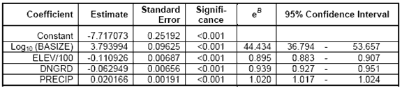
The CMER Water-Typing Model was applied to the LiDAR DEM in the same manner it was applied to the 10m DEM. Downstream gradient (DNGRD), Elevation (ELEV), and Basin Size (BASIZE) were determined by LiDAR using the LiDAR-derived stream network and elevation model. Table 2 provides the results of the logistic regression model (Conrad et al., 2003).
2.3.2 Gradient Model
where B1 is the Gradient Coefficient at -0.209 and B0 is the
Model Constant at 2.765. Logistic regression calculates the
probability of success identified as (i.e., trout presence,
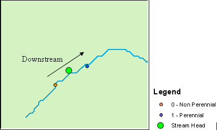
2.4 PIP Model Perennial initiation point standard is defined in WAC 222-16-030(3) and 222-16-031(4) of the Washington State Register. For western Washington sites not in any coastal zone, Type 4 waters begin at a point along the channel where the contributing basin area is at least 21-ha. The PIP Model was based on the techniques described in Conrad et al., (2003) except the logistic regression was used to identifying where perennial flow begins and where it ends instead of fish present. Stream head data locations were collected in the field for 5 sub-basins within a selected site. Points were generated 15 meters upstream and downstream of the stream head in GIS (Figure 6) for clear perennial definition and the following physical attributes were associated with the points to determine which influenced perennial flow:
The points upstream represented non-perennial flow as the points downstream represented perennial flow. Using binary logistic regression and setting 0 for non-perennial and 1 for perennial, the physical attributes associated with each point were used to develop Equation 1 from above and equation 4.
where After applying the model equation in Arc, probability of non-perennial was adjusted from 0.5 to around 0.97 for a conservative approach. This was determined by looking at the histogram in the classification class and moving the class line to the highest possible number without removing the stream network. Regiongroup in ArcTools was then applied to find the continuous parts of the network.
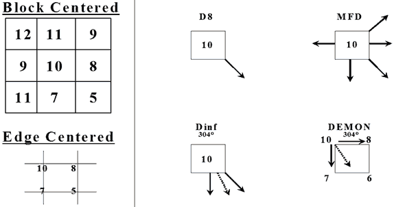
2.5 Flow Direction Methods Utilized
Spatial processing has a limited number of raster-based procedures. Collectively, these raster-based procedures implemented in ARC/INFO utilize the single flow direction (SFD) algorithm (O’Callaghan and Mark 1984). It calculates flow direction as the steepest slope direction, which is determined by the Maximum Downward Gradient (MDG) (Figure 5). This SFD algorithm, also known as the Direction 8 or D-8, is widely used on DEM data analysis and GIS software (e.g., the “Flowdirection” function in ARC/INFO GRID) (Jenson and Domingue 1988). The D-8 raster procedures form the basis for describing and modeling water flow through a digital elevation data set. Using the D-8 directional information associated with each cell, a network of flow from one cell to the next is represented. Using the flow direction information, the number of cells that flow into any cell is tracked and assigned to the cell.
Multiple Flow Direction (MFD) algorithm is the third method that was used for determining flow direction.
2.6 Stream Channel Determination by Flow Accumulation Montgomery and Dietrich (1992) found that landscape dissection into distinct valleys is limited by a threshold of channelization that sets a finite scale to the landscape. This threshold determines the number of sub-basins that exist in the model. A small threshold results in a large number of small basins whereas a large threshold results in a small number of large basins. The threshold is equal to the hillslope length / accumulation that is just shorter than that necessary to support a channel head (Montgomery and Dietrich 1992). A threshold-based approach is most appropriate for modeling channel head locations over shorter, geomorphic time scales (e.g. 102-103 years) than modeling valley development (e.g. 104-106 years) (Montgomery and E. Foufoula-Georgiou 1993). 2.7 Generation of Flow Direction Networks 2.8 Current Hydro Layer Evaluation
2.9 Field Measurements
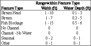
Field planning was done by using LiDAR streams with the DNR hydro layer to locate stream features in the field. The above values were then determined and logged using a Trimble ProXRS GPS unit. The ranges for width and water depth for each stream feature were evaluated (Table 4) as well as the possible values (Table 4) that the features could have associated with it. Fish presence was assessed only by visual inspection of the stream. If a stream did not contain much water, contained many fish barriers, or went underground, it was assumed that no fish would be present. Field work was done April 20th through May 3rd 2005.
3. RESULTS3.1 Flow Direction Comparison
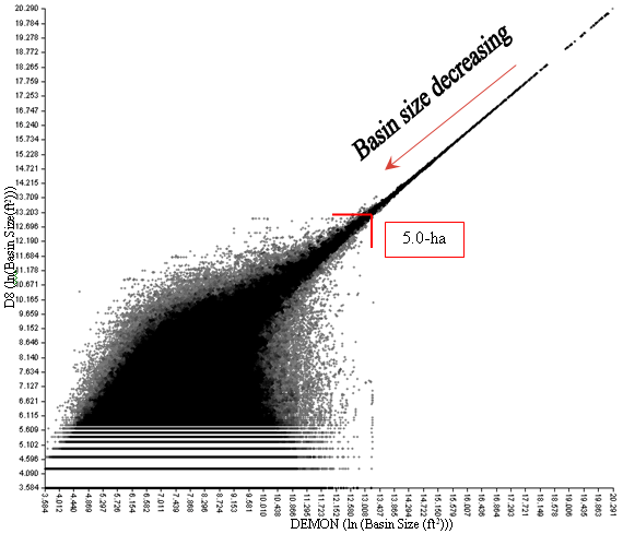
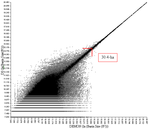
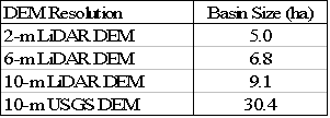
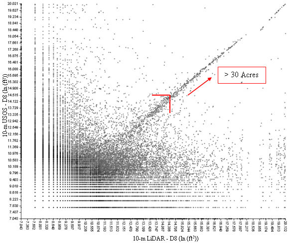
Using LiDAR datasets, D8 determines stream networks as well as DEMON. Endreny and Wood (2003) gave 2D-Lea (a building block in DEMON) the highest ranking in accuracy in comparison to any stream model that was used in their study. The data suggested that increased DEM resolution decreased the need for sophisticated models, reducing processing times required by complex models for high-resolution DEM’s. Since D8 is the most commonly used model and simplest to implement, computational time in computing stream networks is reduced in comparison to DEMON. When comparing a LiDAR derived 10-m DEM with a USGS 10-m DEM, D8 stream channels with a catchment size of about 12-ha and greater somewhat converge between the two DEM’s (Figure 10). When catchments are less than 12-ha, no convergence existed. Since a USGS 10-m DEM contained topographic errors in regard to stream channel location, streams from the LiDAR and USGS were categorized as identical if they were less than 90-m apart to decrease error between the two datasets. This caused differences to decrease significantly between the two stream networks (Appeddix H). These differences occur in Strahler order 1, 2 and 3 streams. The area in the lower middle of Figure 10 corresponds with areas when that the 10-m USGS under predicted stream channels in comparison to the area to the left side of the figure which corresponds to areas of under prediction of the LiDAR 10-m.
3.2 Resolution Effects on Flow Direction Decreasing the LiDAR-DEM resolution to 6-m removed the road effect and placed streams in a more realistic location than the 2-m uncorrected. At 6-m resolution, the stream models could not identify roads or the ditches associated with the roads. As the LiDAR-DEM resolution decreased, road influence decreased. Stream channels, for the most part, followed the corrected 2-m stream network (Figure 13). The advantage of the 6-m LiDAR-DEM was that it provided a significantly improved stream network compared to the 10-m USGS DEM and removed the need for culvert data.
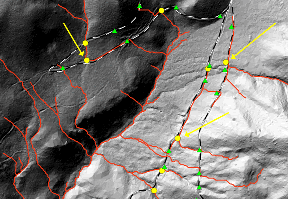
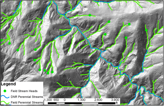
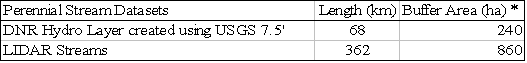
3.3 Assessing the Current Hydro Layer Very few of the streams typed as 5 were dry and most were perennial. Figure 14 illustrates field verified perennial streams identified using 6-m LiDAR DEM versus what the DNR considers perennial. Not all streams were visited due to stream head inaccessibility. There is a 530% increase in perennial stream length going from the DNR hydro layer perennial steams to the field verified perennial streams (Table 6). If a uniform buffer of 30 meters, a standard DNR regulation estimate, was placed around the stream channels, there would be a 350% increase in buffered area.
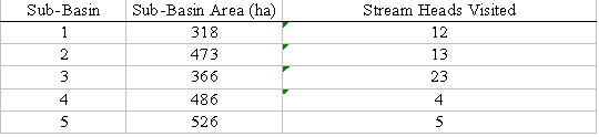
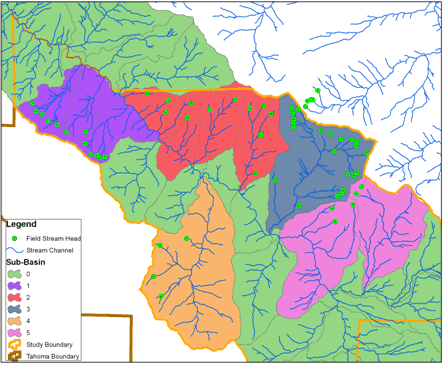
In the field, 61 stream heads were located within the Mineral Creek, North Fork watershed. Table 7 lists the distribution on the stream heads and Figure 17 displays the locations of the heads. Using the method described in the PIP Model section, 53 heads were selected at random within the study site to be used to create a model to predict perennial initiation points (PIP).
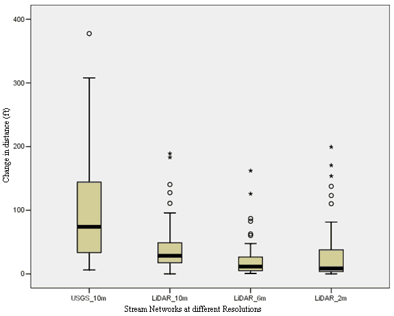
The final Linear Regression model for PIP used fewer variables than expected. The final model selected Basin Size using D8, Percent Slope, and Precipitation. Downstream gradient, forest density, elevation, and site class could not be used to create the equation for determining the probability of stream head locations based on a 0.05 significance level. Table 8 summarizes the variables uses for the regression. The Hosmer-Lemeshow chi-square statistic for this model was 10.262 and the -2 Log likelihood statistic was 80.130. Self-classification accuracies for this model were 77.4% for perennial flow and 88.7% for non-perennial flow. APPENDIX I provides further statistics regarding regression. Using a model based on basin size alone for predicting perennial stream channels would be less accurate than the above model. The Hosmer-Lemeshow chi-square statistic for basin size model was 8.864 and the -2 Log likelihood statistic was 91.840. Self-classification accuracies for the basin size model were 77.4% for perennial flow and 84.9% for non-perennial flow. Overall, the average basin size for perennial flow for this model is 1.28-ha (3.16 acres). Both models can over estimate the extent of perennial stream channels by placing flow upstream of the PIP. Using the conservative approach described in the PIP Model section it has the potential to under predict perennial flow. Using average basin size determined from the field data, the average value is 2.2-ha (5.44 acres). This average over and under predicts perennial flow. Since the Washington State Register defines contributing basin area as at least 21-ha (52 acres), all models and approaches would significantly correct WAC estimations. The model in Table 8 was run at 4 different resolutions, 2-m, 6-m, 10-m LiDAR and a 10-m USGS DEM. Figure 18 illustrates the change in distance between modeled stream head location and field-verified stream head location for different DEM resolutions. This indicates that at all LiDAR resolutions, the error is relatively the same. The 10-m USGS DEM average distance and spread are higher than the LiDAR. This confirms that LiDAR improves upon modeling stream heads more accurately than a 10-m USGS DEM. The reasoning for high distances in the figure is due to the model not predicting a stream where the field verified stream head was located.
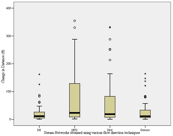
The PIP Model was tested on the various flow direction techniques listed in the “Flow Direction Methods Utilized” section to test which flow direction algorithm worked best in locating perennial flow. Because of the differences in the MFD and Dinf from D8, a separate bilinear regression model was created but none of the variables were significant based on a 0.05 significance level. The regression model in Table 8 was then used on the various algorithms on a 6-m LiDAR DEM to see the errors in predicted stream head locations. DEMON and D8 stream heads correlated in the difference in distance from the field-verified stream heads. Dinf and MFD increased in the difference in distance from field stream heads when compared to D8 (Figure 19). Finding a way to develop a bilinear regression model for Dinf and MFD would reduce the data error illustrated below.
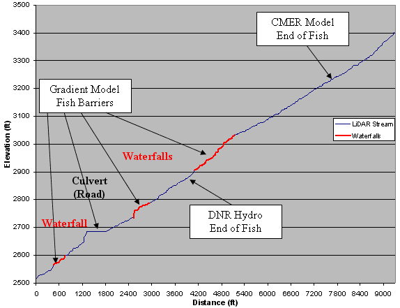
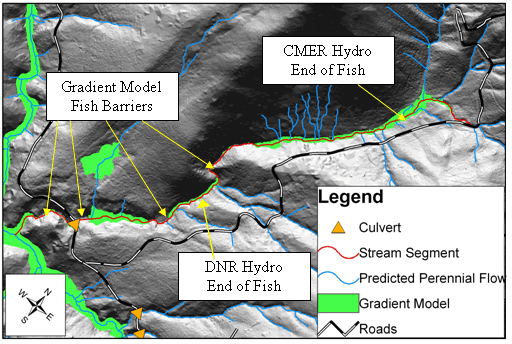
3.5 Determining Fish Stream Habitat Figure 20 displays a longitudinal profile of a selected creek generated by a LiDAR DEM. The red zones indicate field verified waterfalls and culvert/road locations that the Gradient Model identified. These waterfalls can range from 1 to 6+ meters tall. If trout were able to pass these barriers, the CMER Model would be correct in its estimation. Figure 21 shows the predicted fish habitat estimated by the Gradient Model. The CMER Model and DNR Hydro layer are within the predicted fish habitat area but overlook small, but critical segments that act as fish barriers. Gaps in between the green zones are the waterfall and culvert barriers. These results were similar to the results for other stream channels throughout the study site.
The CMER Model and the DNR Hydro layer predicted fish presents further up stream than the Gradient Model. Using the Gradient Model, fish-bearing streams decrease 24% from the DNR Hydro layer (Table 9). The CMER Model potentially overestimates fish-bearing streams by 54% when compared to the Gradient Model.
The LiDAR DEM modeled fish barriers more accurately than a 10-m USGS DEM (Figure 20). At times, the USGS dataset resulted in incorrect locations for major waterfalls. In many cases, major waterfalls were not identified at all. For the most part, the USGS DEM identified the larger streams at the study site as accurately as the LiDAR DEM. This makes sense considering how the USGS DEM was created. Large streams are visible from aerial photos allowing elevation readings to be fairly accurate.
3.6 Weaknesses and Shortcomings Current spatial information usually does not have the fine resolution of a LiDAR dataset. Soils surveys, geology, and site class information are at lower resolutions than LiDAR so trying to develop a model that uses those themes could be difficult. These datasets would need to be at a higher resolution to better match a LiDAR derived dataset. The lack of a high-resolution site class map may explain why site class could not be used in the perennial stream regression model. The major limitation to the regression model used to predict perennial flow is that it is site specific. While it proved to be more accurate than the current datasets available, accuracy may decrease when applying the model to a variety of landscape types. Data collected on a larger, more diverse area would generate a model better able to model landscapes. In the middle of Figure 21 just below the “CMER Hydro End of Fish” label, a series of stream channels were identified in blue. This is a misrepresentation of the landscape due to dense forest canopy. A dense canopy will limit the amount of laser ground returns causing a loss of resolution in specific locations. A way to correct this problem would be to conduct field surveys of the landscape at those locations. 4. CONCLUSIONWhen used with high-resolution DEMs, the most common and least sophisticated algorithm to locate stream channels based on flow, D8, proved to be sufficient when compared to more complicated and process demanding algorithms. The advantage of D8 is that most programs like ArcGIS come standard with this algorithm to locate stream networks. In generating stream data using LiDAR, a computer with a high-speed processor is not necessary. Increasing surface topographic resolution allowed an increase in the precision of stream channel modeling. Since the LiDAR DEM that was used for this project was at a 2-m resolution, decreasing the resolution of the LiDAR did not alter the ability to model locations of stream channels. The resolution at 2-m proved sensitive for the models used requiring a culvert dataset to alter stream flow off the road networks. Decreasing resolution to 6-m eliminates road effect errors. Relying on the resolution of a 10-m USGS DEM proved inadequate in modeling head water streams. High-resolution DEMs are necessary to accurately model stream networks. As shown, a LiDAR DEM is a great source for generating hydrologic data by identifying probable perennial stream channels and locating fish barriers along a given stream. The ability to accurately model headwater streams and identify fish-bearing streams allows stream buffer zones to be in their topographically correct location. In turn it will allow for better planning at both the strategic (sustainable harvest volume calculations) and tactical or map scale level (forest operations planning at the watershed level) rather than having to rely on time-consuming field reconnaissance.
REFERENCES
APPENDICESE
|