 |
 |
 |
 |


Cross-drain Placement to Reduce Sediment
Delivery from Forest Roads to Streams
|
by Florentiu Damian
Cross-drain Placement to Reduce Sediment Delivery from Forest Roads to Streams Florentiu Damian Chair of the Supervisory Committee:
A model has been developed which allows a designer to place ditch relief culverts at various locations and subsequently evaluate their impact on sediment delivery to streams. The main feature of the model is its immediate feedback to the forest engineer in visual as well as quantitative form. It allows the designer to dynamically assess the sediment impacts associated with each culvert as it is placed on the road network. Sediment delivery and routing algorithms are based on accepted methodologies. Current as well as planned roads can be evaluated and the potential for improvements documented in a quantifiable and repeatable way. The model was tested on a portion of the Tahoma State Forest, situated south of Mt. Rainier. Two existing road systems with 28 and 39 stream crossings and 82 and 86 cross drain culverts respectively, were analyzed. Interactively relocating 20 and 35 of the cross drains resulted in a three quarter reduction in sediment delivered to the stream system. The last culvert was usually placed about 100 - 200 ft of a stream according to local conditions, challenging one of the regulatory recommendations to place a cross drain within 100 ft of a stream crossing. Forest engineers and regulators now have a design tool to assess effectiveness of a cross drain system rather then simply relying on culvert spacing and count.
|
||||||||||||||||||||||||||||||||||||||||||||||||||||||||||||||||||||||||||||||||||||||||||||||||||||||||||||||||||||||||||||||||||||||||||||||||||||||||||||||||||||||||||||||||||||||||||||||||||||||||||||||||||||||||||||||||||||||||||||||||||||||||||||||||||||||||
| Figure 01 | Schematics of common cross drain types |
| Figure 02 | Cross sectional prism types with their drainage patterns |
| Figure 03 | Cross section of insloped road prism with cross drain |
| Figure 04 | Cross drain system dispersing sediment |
| Figure 05 | Screen capture of the WEPP:Road interface |
| Figure 06 | Effects of moving cut-off culvert C along the road alignment |
| Figure 07 | Analysis setup for a single cut-off culvert scenario |
| Figure 08 | Sediment delivery rate to stream for various sediment production rates |
| Figure 09 | Sediment delivery rates for various stream crossing angles |
| Figure 10 | Setup for the two cross drain experiment |
| Figure 11 | Example of a real case road layout with culverts |
| Figure 12 | Flow chart of cross drain design workflow |
| Figure 13 | Sediment delivery represented as proportional symbols |
| Figure 14 | CULSED Model-View-Controller internal architecture |
| Figure 15 | Logical network of the ditch model |
| Figure 16 | Shaded relief model of the North Tahoma planning area |
| Figure 17 | Initial sedimentation from East North Tahoma road network |
| Figure 18 | Initial sedimentation from West North Tahoma road network |
| Figure 19 | Composite map of a culvert placement investigation process |
| Figure 20 | Sediment delivery from East North Tahoma road network after redesigning the cross drain system |
| Figure 21 | Sediment delivery from West North Tahoma road network after redesigning the cross drain system |
| Figure 22 | Topographic detail of North Tahoma, 6ft resolution DEM |
| Figure 23 | The Component Category Manager Application for registering CULSED components |
| Figure 24 | The CULSED toolbar |
| Figure 25 | Start menu item |
| Figure 26 | Set up road grade menu |
| Figure 27 | Set up road intersections with more than one water routing choice |
| Figure 28 | Sediment modeling parameters |
| Figure 29 | Option menu. Default Sediment Model (left), Default Road (right) |
| Figure 30 | Road Geometry Setup has been run. A road grade is computed |
| Figure 31 | Flow Setup and Sediment Analysis have been run |
| Figure 32 | Culverts have been moved to near optimal locations |
Tables
| Table 01 | Reduction of total sediment delivered (overland and ditch) with 2 culverts |
![]()
The Road Sedimentation Problem
Road Prism Structure and Drainage Patterns
Forest roads are at the core of modern forestry, providing quick,
economical access to the wooded areas. To facilitate forest operations
in areas managed for timber production, a well developed network
of roads must exist. Timber harvesting and forest management
activities drive the expansion of the existing networks into
the inaccessible
parts of watersheds and sub-basins. As engineered structures
on the landscape, forest roads have the potential to disrupt
the drainage
characteristics of the watersheds they traverse by altering their
natural flow patterns. Water from precipitation fallen on the
exposed road surface, moving under the influence of gravity,
follows a
new path dictated by the local road grade. The cuts required
by the basic structure of a road prism across a hillside also
capture
overland flow in close vicinity of the road tread. The accumulation
and movement of this water within the roadway is detrimental
to the well functioning of the road (Schiess and Whitaker
1986).
Problems
ranging from erosion of the traveling surface to saturation of
the sub-grade and mass failure stem from these circumstances.
Such processes are usually accelerated during storm events
as larger
volumes of water move at higher velocities, developing more destructive
energy. In order to keep the road prism in good condition and
avoid structural damage, roads are outfitted with drainage
features.
Three essential prism components determine the water flow within
the roadway: the road crown, the road ditch and the cross-drains.
The crown represents the side sloping of the road surface. Its
main role is to disperse water laterally away from the tread and
prevent harmful flow routing along the travel surface. The side
ditch, when present, collects and routes water longitudinally along
the road alignment towards the nearest stream crossing or cross-drain
structure. The cross drains are routing elements that empty the
side ditch and redirect its accumulated water across and away from
the road prism, onto the side slope, where it will reenter the
natural flow regime. Frequently, cross drains are implemented by
drainage pipes built into the road bed but other, less common implementations
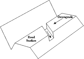
exist as well (Figure 1).
 |
 |
| a. Open top culvert | b. Intercepting rolling dip |
|
|
| c. Pipe culvert |
| Figure 1: | Schematics of common cross drain types |
![]()
According to their drainage configuration forest roads can be classified in the following categories: insloped with a ditch, crowned with a ditch, outsloped with ditch and outsloped with no ditch (Figure 2). Each of these types generates different drainage patterns and impacts the original watershed drainage accordingly.
 |
 |
| a. Insloped with side ditch | b. Outsloped with side ditch |
 |
 |
| c. Crowned with side ditch | d. Outsloped with no ditch |
 |
|
| c. Insloped with no side ditch |
| Figure 2: | Cross sectional prism types with their drainage patterns |
The insloped roads with a side ditch are a common occurrence among forest roads due in part to their ease of maintenance and increased traffic security. The drainage system of an insloped road involves a side ditch, cross drains and stream crossings. The surface of the road, being sloped inwards toward the cut slope, reroutes all water it captures to the side ditch. Consequently, the surface runoff intercepted by the cut bank is concentrated with the rerouted road capture. This can potentially lead to the accumulation of high volumes of water in the ditch. If no cross drains are present this water spills out at the end of the ditch, often directly into a stream at the nearest stream crossing. In cases where the road grade is relatively high, the energy of the moving water can reach potentially destructive levels. Cross drains are placed along the road alignment at various locations to empty the side ditch and reduce the possibility of water induced road and environmental problems.
At the opposite pole of road prism drainage types are the outsloped roads with no side ditch. The outlsoped roads with no ditch disperse all the water they capture on their fill slope. In the absence of a side ditch, concentration and rerouting of large volumes of water does not take place. As the energy of the flowing water is kept to lower levels, its damaging potential is also reduced. Moreover, the lack of direct ditch drainage into a stream network induces less hydrologic disturbance. Harmful processes of erosion and sedimentation generated by moving water are minimal. From an environmental standpoint, the outsloped road type represents a more suitable design. However, traffic security concerns raised by log trucks and heavy equipment, critically restrict its usability. Outsloping is normally applied to minor roads and spurs.
Other intermediary road types inheriting physical characteristics from both the insloped and outlsoped roads do exist (Figure 2). Their hydrologic impacts on the environment are closer to one or the other base types described above, with variations dictated by their elemental differences.
![]()
Sediment Production and Delivery Mechanisms
Stream sedimentation
is an environmental problem generated by the expansion of sediment
into streams in excess of the natural
amount
from hill-slope erosion and soil creep. Forest roads have been
identified as a major contributor to sedimentation. Fine sediment
generated by roads is transported into adjacent streams, leading
to degradation of water quality and damage to aquatic habitat
(WA Forest Practices Board 2000). Sedimentation from roads
can be approached
from two major perspectives: sediment production and sediment
delivery.
Sediment production refers to the physical generation of sediment, the process of detaching soil and parent material particles under the influence of various agents. Different premises govern the generation of sediment on each individual road component. The cut and fill slopes are subject to surface erosion occurring when detachable soils are exposed to erosion factors such as: overland flow, raindrop splash, freeze-thaw, dry ravel, and other biogenic processes (WA Forest Practices Board 1997). The litter cover, typically present in a forested environment, protects the soil against all these factors by dissipating erosive energy before it reaches the surface. Road construction operations however, expose the soils on the cut and fill banks, increasing the potential for particle detachment. New roads tend to generate significant quantities of sediment for the first few years of their existence but in time, as side slopes re-vegetate, the sediment production drops. The road’s running surface is another major sediment producer. Traffic is the destructive agent acting upon the surface material. The action of tires against the road surface will grind and dislocate particles into smaller units that can eventually be carried away by other agents like water and wind. Some researches consider traffic to be the single most essential factor influencing sediment generation, capable of increasing sediment amounts by one order of magnitude or more (Reid and Dunne 1984). The side ditch can also be considered as a source of sediment where the erosion is caused by moving water. In the cases where water gains sufficient energy to overcome the soil’s sheer strength, particle detachment is observed.
Sediment delivery refers here to the transportation of sediment generated by the road prism into neighboring stream networks. Fine sediment travels in suspension, carried by overland flowing water along its paths towards the river system. As an active component of watershed hydrology, the road drainage has a fundamental impact on the sediment delivery process. By determining the local water flow within and about the roadway, the road drainage implicitly controls the sediment routing (Section: Road Crowning and Drainage Patterns). The various road drainage configurations in conjunction with the actual road location drastically affect the amount of sediment reaching the stream. For example, in the cases of roads that have numerous water crossings, the presence of a side ditch establishes a direct connectivity between the road drainage and the stream network. The side ditch typically empties at stream crossings, unloading all accumulated sediment into the water. This configuration results in a high potential for stream sedimentation. Other high delivery scenarios include valley bottom roads that run parallel and within close distance to a stream. Large quantities of sediment can reach the stream laterally through surface runoff and water diverted from existing cross drain culverts. On contrast, roads with an outsloped surface geometry and ridge top roads located far away from any streams, have minimal impacts on sedimentation and can be considered as disconnected from the natural watershed drainage.
An important aspect when examining overland delivery on lateral slopes is the site’s filtering potential. Through filtering, parts of the sediment produced by the road are deposited before they have a chance to enter the stream network. Filtering is a complex process, fundamentally based on energy loss and infiltration. The carrying water’s transport capacity is proportional to its velocity. By reducing water velocity soil particles are dropped from suspension and settle down. The porosity of the soil surface influences the infiltration rates and further contributes to the deposition and absorption of fine sediment. In practice, a reduction of sediment delivery is obtained by diverting the water onto vegetated side slopes where the litter layer, plants, and gentle slopes can slow down the surface runoff enough to trigger these filtering effects. Various researchers have shown that the nature of the parent material and the local micro-topographical features have a major influence on the distance the sediment can travel downhill on a side slope. In some extreme cases these distances can be fairly significant (Ketcheson and Megahan 1996), but usually the filtering effects are seen within the first 200 ft from the road (WA Forest Practices Board 1997).
![]()
Current Management Techniques for Reducing Sediment Impacts from
Forest Roads
Contemporary forest practices regulation requires protection
of the neighboring streams from harmful road generated sediment.
Although
no quantification of minimum acceptable impacts is provided,
it is desired that water quality and aquatic habitat not be affected.
Ideally no sediment from roads would be delivered to streams
(WA
Forest Practices Board 2000). In order to meet regulation requirements
several road management techniques are effectively applied.
A large part of these techniques address the sedimentation at the production end, acting directly onto the sediment producing factors:
- Road resurfacing is the process of replacing a highly erodible road surface like native dirt or thin gravel with a more traffic resistant surface such as thick gravel or pavement. This method can be very effective but also labor intensive and expensive.
- Road gating reduces traffic during the non-logging seasons. Unused roads are less likely to produce sediment; however the major part of the sediment is still generated during the high traffic season.
- Road abandonment and decommissioning are methods that alter the road prism in order to restore the natural drainage patterns. With abandonment a road is prepared for an extended period of stagnation by removing stream crossings culverts, closing it to traffic and outfitting it with water bars. Decommissioning implies the destruction of the entire road prism, returning the side slope to an approximate natural state. A drastic decrease in sedimentation can be obtained this way.
- Re-vegetation represents an accelerated stabilization of the road’s cut and fill banks as means to reducing sediment production especially during the first years of the roads existence when these parts are more active.
Other methods are centered on the actual sediment transport, designed to decrease sediment impacts by obstructing the physical flow of sediment into streams:
- Sediment trapping is a popular technique of filtering ditch water prior to spilling into the streams at stream crossings. The sediment traps are manmade devices that intercept sediment, typically through decantation, and require periodical maintenance to assure optimal functionality. This method has been proved effective especially when combined with other sediment reducing means described above.
Cross Drain Systems and Sediment Reduction
Cross drain systems have originally been devised as an engineered
solution for reducing the adverse effects of excess water
within the roadway. They are commonly composed of culverts
placed at
key locations along the road alignment that drain the side
ditch of
its accumulated water. Positioning and spacing of these culverts
are essential for keeping the road prism in a well functioning
state. With the recent evolution of road design into a more
environmentally aware paradigm, a new challenge for the cross
drain systems has
surfaced. Due to their intrinsic properties of intercepting
and rerouting sediment-laden ditch water, cross drain systems
emerged
as a potential solution to the stream sedimentation problem.
Thus, in addition to the functionality dictated by the prism
health state,
another prerequisite was added: to reduce sediment delivery
to stream networks.
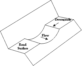
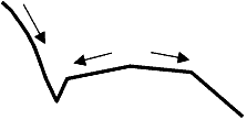
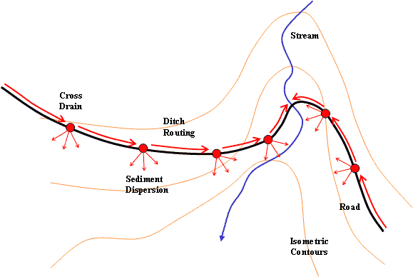
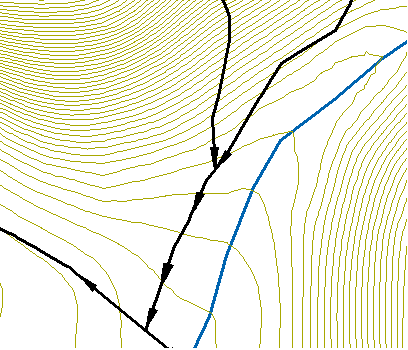
Designing cross drain systems to meet this new functionality asks for an analysis of the potential amount of sediment delivered by each culvert. In order to reduce sediment delivery, a cross drain must divert the sediment-laden water from the road ditch onto the side slope where it can be dispersed and filtered prior to reaching a stream (Figure 3).
 |
|
| Figure 3: | Cross section of insloped road prism with cross drain; A – sediment accumulated along the ditch from uphill sections; B – sediment generated by the cut slope; C – sediment generated by the road thread; D – sediment dispersed by cross drain; E – new sediment accumulation cycle. |
![]()
The filtering capabilities of a side slopes vary with location
as micro-topography and vegetation conditions fluctuate (Section:
Sediment Production and Delivery Mechanisms). As sediment
accumulates continuously along the stretches of road between culverts,
the
amount available at each location is directly affected by the cross
drain spacing. An effective reduction of the sediment delivery
from a road network requires a certain number of culverts strategically
placed to take advantage of local filtering capabilities (Figure
4). It is important to note that these locations may not always
coincide with optimal locations for prism drainage but are not
mutually exclusive. When the amount of sediment available for delivery
at a particular culvert location exceeds the lateral slope’s
filtering potential sediment could still reach the stream. These
cases are often met
where a road is located too close to the valley bottom or a cross
drain is placed too close to a stream crossing.
 |
|
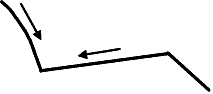
| Figure 4: | Cross drain system dispersing sediment. The red arrows indicate sediment routing direction. |
![]()
Policy and Design Restrictions
The recent aquatic wildlife crisis in the Pacific Northwest in
conjunction with an increased awareness of environmental issues
led to the adoption of a new policy for the timber industry.
As forest roads are considered potentially harmful to the environment
a particular set of restrictions has been imposed on forest road
construction that directly affects the cross drain system design.
Designers are required to minimize entry of ditch water and surface
sediment into streams by dispersing sediment onto the forest
floor.
Cross drain spacing is seen as an essential aspect of sedimentation reduction. Generally, cross drains are to be spaced at regular intervals along the road. The distance between culverts is provided as a function of road grade, side slope, average distance above streams, road surface condition and use, precipitation, and soil erosion potential. The rules also specify that the distance between a stream crossing and the first upslope cross drain is important to the volume of sediment delivered and recommend that a culvert should be installed 50 to 100 feet above all stream crossings (WA Forest Practices Board Manual 2000).
Even though the site filtering potential is not explicitly referenced by the current regulation, the cases where culverts are too close to a stream crossing and diverted sediment could still reach the stream network are recognized. The manual recommends either avoidance of such situations or implementation of additional measures such as sediment traps or ponds, rock armored ditches, and vegetated ditches.
A sufficient number of cross drains should be installed in order to prevent ditch scour, over flowing cross drain capacity or erosion at cross drain outlets. The manual requires designers to make use of natural swales that the road crosses in order to avoid rerouting water along the ditch, where it can pick up and transport sediment.
Using these guidelines makes it possible for an experienced professional to design a functional cross drain system. However, one potential draw back of spacing cross drains at regular intervals is that the site filtering potential might not be fully exploited. In areas highly susceptible to sedimentation, a non-uniform spacing of culverts to take advantage of local terrain and lateral sediment retention capabilities might be more suitable. For a more rigorous analysis of the sediment production and delivery from forest roads some specific software tools exist.
![]()
Sediment Modeling and Existing Tools
Due to the complex nature of the sedimentation process a precise
measurement of sediment impacts form forest roads is not always
possible. Several software programs were created in order to
model the road-stream sediment interaction and estimate the
amount of
sediment delivered.
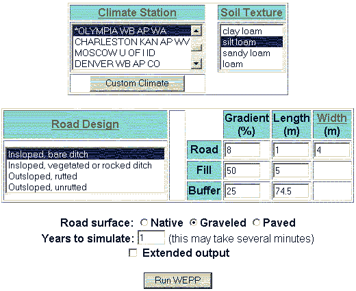
The Water Erosion Prediction Project (WEPP) is a simulation program, originally developed for agricultural purposes as a replacement for the Universal Soil Loss Equation (Elliot et al. 1999b). It is a complex program that models the processes that lead to erosion including infiltration and runoff, soil detachment, transport and deposition, plant growth and residue decomposition. WEPP works with a given slope profile and runs simulations over a specified period of time under a multitude of customizable parameters. The Forest Service Moscow Lab has developed a set of specialized interfaces in order to simplify WEPP use for erosion and sediment delivery from forest roads.
X-DRAIN is a basic interface to accessing predicted sediment yields from over 130,000 WEPP simulations ran by soil erosion specialists (Elliot et al. 1999a). It was developed to simplify and speed up the application of WEPP for simple forest road settings. The end user has limited control over climate, soil, side slope and distance to streams parameters. Road geometry and distance to streams are assumed uniform along the analyzed road segment. The total sediment yield in lb/year is presented on a tabular form for a fixed number of combinations of road gradient and cross drain spacing values.
WEPP:Road is meant to be a more refined sediment modeler capable of modeling one road segment at the time. As inputs, it accepts road surface information and a customizable climate description. The modeling can be done over a user defined period of time (Figure 5). The sediment yield to the stream network in lb is reported as a single number together with the additional average precipitation, runoff, and the amount of sediment leaving the eroding portion of the road prism. There is also the option of an abbreviated hillslope output presenting a distribution of erosion and deposition, the presence of a sediment plume in the forest, and the particle size distribution of sediment delivered to the channel (Elliot et al. 1999c).
 |
|
| Figure 5: | Screen capture of the WEPP:Road interface. |
![]()
One major limitation of the WEPP based programs is that they are spatially non-explicit and thus incapable of distinctly placing the sedimentation processes within a road network. Other organizations have approached this problem within a more spatially aware context using Geographic Information Systems (GIS) as a base for their analysis. GIS have become a standard in environmental modeling. Their capacity of modeling overland flow is what makes them indispensable to spatially distributed phenomena involving streams and water routing.
SEDMODL is a GIS based, road erosion and delivery model developed by Boise Cascade Corporation in cooperation with the National Council on Air and Stream Improvement. The model identifies road segments with a high potential for delivering sediment to streams in a given watershed. It uses spatial information to determine the proximity of the roads to the stream network. Sediment delivery is then calculated for the roads that drain to streams using methods derived from the Washington Department of Natural Resources Standard Method for Conducting Watershed Analysis and WEPP. The program is designed as a flexible, multipurpose tool that can be used both for screening purposes or a more detailed sediment analysis. For more reliable results a set of specific road attributes is required. They can include: road use, surface type, road width, construction year, cutslope height, road geometry type, and road gradient. If culvert locations are known they can be inputted as GIS layer and will affect sediment computations accordingly (National Center for Air and Stream Improvement 2002).
The Washington Road Surface Erosion Model (WARSEM) is new software from Washington Department of Natural Resources intended as a long term road management planning tool. It can model sedimentation and drainage at four different levels from the broad basin scope to the individual road segment. An increasingly complex amount of road information is required with each superior level. The model stresses out the importance of accurate, field verified input data towards a successful sediment budget. The model is implemented as an Access database without a spatial component. SEDMODEL2 results can be imported to generate performance metrics in a long term best management practices analysis (Watershed GeoDynamic et al. 2003).
![]()
The
Need for a Specialized Cross Drain Design Tool
The contemporary emphasis on modeling the processes that lead to
erosion and sediment transport resulted in a well represented collection
of computer programs. These software tools were created as analysis
packages and perform well when used for general identification
of sedimentation problem areas or when examining isolated parts
of already built road networks. However, as multiple design alternatives
are evaluated during the road design stage, these tools may fall
short of functionality, prove slow and relatively ineffective.
They are focused on accurate modeling of sedimentation processes
but do not provide the means for minimizing total sediment delivered,
especially important when designing cross drain systems. None of
these tools actively address the question of how culvert placement
impacts sediment delivery to stream networks. For example, as WEPP:Road
works with only one road segment at a time, using it to determine
best culvert locations and optimal spacing of a road drainage system
would require multiple simulations for each potential culvert movement.
A typical investigation involving many case scenarios, with culverts
placed at various locations, requires repeated runs of the model
for all road segments affected by a the presence of a cross drain,
at each particular snap shot. This could become a very inefficient,
time-consuming procedure especially for long roads with multiple
cross-drains where sediment producing factors vary a lot. XDRAIN
on the other hand, can only be used for roads with uniform conditions,
being limited to a constant road grade and considering culverts
to be uniformly spaced. Users cannot tell which one of the culverts
has more potential to deliver sediment and it is impossible to
know what placement would possibly reduce sediment impact to streams.
SEDMODL automatically identifies and displays road segments that
are probable to deliver sediment based on, among other factors,
a GIS layer of known culvert locations. If trying to find the best
possible locations for existing culverts or revise the number of
culverts to reduce sediment impacts, the culvert layer has to be
modified manually and the model rerun. This process, as in the
WEPP case, can become inefficient if repeated many times.
There is presently no methodology that allows a road engineer
to quantify the effects of varying culvert spacing or selecting
specific culvert locations, on sediment delivery to streams. The
absence of such a design tool makes it more difficult to take culvert
spacing into account as an effective solution for reducing sediment
impacts from forest roads.
Goals and Objectives
Goal:
- Investigate culvert placement as a method for reducing sediment delivery to stream networks from forest roads.
Objectives:
- Develop a software program that allows engineers to quantify the
effects of varying culvert location along a road network with the
following properties:
- Spatially explicit – associates sedimentation to precise locations on along the road.
- Integrated with a standard geographic information system platform.
- Efficient - evaluates alternatives in a timely manner without using external programs of procedures.
- Ease to use.
- Illustrate the effectiveness of culvert placement for reducing
sediment delivery to streams with a real road-setting
example.

Concepts
The Cut-Off Culvert
In order to analyze cross drain systems design and minimization
of sediment delivery from forest roads we introduce the term Cut-Off
Culvert. The cut-off culvert is any culvert that directs water
across a vegetated hillslope. This differs from standard drainage
culverts that divert water into a stream channel. Typically cutoff
culverts are placed solely to reduce ditch erosion and maintain
ditch flow capacity. Concurrently they can also be used to reduce
the direct delivery of sediment-laden water from the road’s
ditch by diverting it onto the forest floor where a major part
of the sediment will be filtered out and retained prior to entering
the stream (Section: Cross Drain Systems and Sediment Reduction).
From the sediment reduction standpoint, the cut-off culvert’s
location is crucial to the well functioning of a cross drain system.
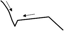
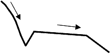
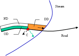
Figure 6 shows the effects of placing a cut-off culvert at different
locations along a road segment.
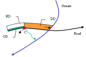
The volumes of overland delivery (OD) from culvert C after filtering and direct delivery from ditch (DD) are represented by the two colored areas. The total sediment delivered is given by the summation of these two areas and fluctuates with culvert placement. Assume that the amount of sediment produced by the road prism is constant in all three cases, the side slope has uniform filtering capabilities and the lateral filtering is proportional with the distance the sediment must travel downhill this side slope. It can be noticed that by placing culvert C closer to the stream intersection increases its lateral delivery potential while it decreases the direct delivery from ditch (Figure 6b). Conversely moving culvert C away from the intersection gives more filtering power but also leaves more contributing area for direct delivery (Figure 6c). The question of ideal placement of a cut-off culvert becomes a question of maximizing the filtered sediment (ND) at the expense of direct delivery (DD) and overland delivery (OD).
 |
 |
| a. Initial set-up | b. Culvert moved towards the stream crossing |
 |
OD – Amount of sediment
from overland delivery DD – Amount of sediment from delivered directly by the road ditch ND – Amount of sediment not delivered (filtered) |
| c. Culvert moved away from stream crossing |
| Figure 6: | Effects of moving cut-off culvert C along the road alignment. To minimize sediment delivery the sum of overland delivery OD and direct delivery DD has to be minimized by increasing filtering ND. |
![]()
Minimization
of Sediment Delivery for a Simple Case
To explore the optimal location of a single cut-off culvert a simplified
case scenario was built (Figure 7). A straight 150m long road segment,
of constant grade, crossing a uniform slope hillside intersects
a stream at an angle α . The sediment generating factors along
the road segment and the filtering characteristics of the side
slope
are invariable. A cut-off culvert is placed at a random location
along the road alignment. A direct delivery distance through the
ditch (d) and a sediment- filtering potential characterize every
possible location.
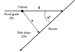 |
Figure 7: Analysis setup for a single cut-off culvert scenario |
The water dispersed by the culvert in question usually travels towards the stream on a sinuous path following the local topography (flow distance). For simplification purposes assume that the side slope’s topography is uniformly flat and this flow path is identical to a straight perpendicular to the stream (Euclidian distance). The generic term: overland distance (o) refers here to the Euclidian distance between culvert and stream (Figure 7).
The sediment filtering potential expressed here as the proportion of total available sediment delivered to stream (F), varies with the overland distance (o) as well as other site-specific factors like: soil types, local gradient and vegetation cover. Because the overland distance (o) is in this case proportional with the direct distance (d) it can be stated that the filtering potential (F) is also proportional with the direct distance (d). By expressing F as a function of d the total sediment delivered to the stream can be budgeted with Equation 1:
Equation 1: Total sediment as a function of culvert location
d |
K = sediment production rate (kg/unit length of road prism)
L = total road length
F = fraction of sediment delivered (non-dimensional)
The minimum delivery T is obtained when:
Equation 2: Optimal
culvert location d
|
![]()
The optimal location for cut-off culvert C can be obtained by solving differential Equation 2 for d. It can be noticed that the optimal location of C is not dependent on the sediment production rate K but only on the road-stream geometry and the local filtering characteristics.
In actuality, absolute deterministic models of side slope filtering
potential to take into account every combination of factors encountered
on forested terrain are not currently available. As the fraction
of sediment delivered F cannot easily be determined a completely
analytical approach to culvert optimization is not feasible.
Various researchers have approached the problem on empirical bases,
using statistical inference on their field measurements in order
to model sediment delivery. Equation 3 describes the volume of
sediment deposition as a function of the travel distance for particular
conditions encountered in the Idaho Batholith (Ketcheson and
Megahan 1996).
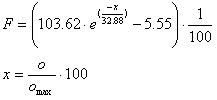 |
Equation 3: Empirically
derived fraction of sediment delivered expressed as the
percent of the available sediment volume; o max is
characteristic to granitic waterseds in Idaho Batholith
(Ketcheson and
Megahan 1996)
|
By plugging equation 4 into the sediment budget equation the total sediment delivered for our case scenario can be plotted as a function of the culvert location (Figure 8). A family of curves is shown for various sediment production rates. A minimum delivery is obtained with culvert C at 50 meters away from the stream intersection all across these different sediment production regimes. It is important to note that empirically derived equation 4 cannot be universally applied. However, assuming that in most cases overland sediment delivery follows analogous invert exponential distributions (Burroughs and King 1989) it is possible to effectively approximate near optimal locations for culverts.
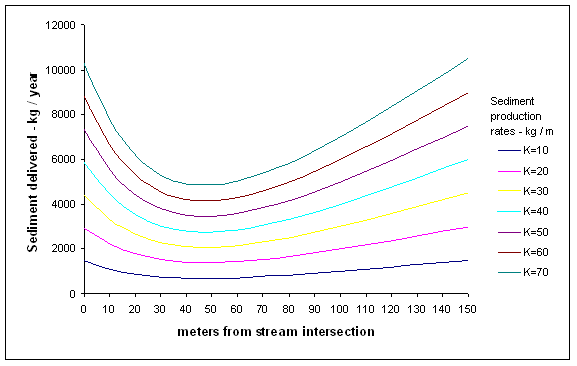 |
|
| Figure 8: | Sediment delivery rate to stream for various sediment production rates. Road segment is 150 m long, 4m wide; alpha is 45 degrees; sediment production rates K in kg/meter of road prism. The fraction of sediment delivered is computed with Equation 3. |
![]()
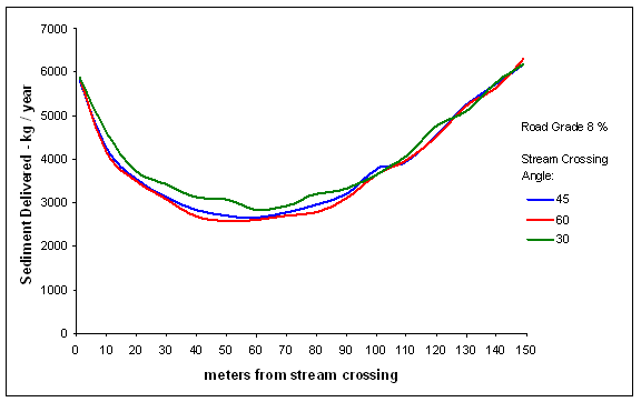
Similar approaches have already been incorporated into some more advanced sediment modeling programs. Therefore in order to further investigate the optimal placing of a cut-off culvert, the F.S. WEPP:Road interface was called upon to provide the modeling for the sediment production and delivery for the proposed case scenario. An experiment was conducted where culvert C from the set-up in Figure 7 was incrementally moved along the road segment. The sediment impacts associated with each of these locations were quantified by WEPP simulations run at the Forest Service web site. The sediment production parameters were: 4m wide, insloped bare ditch road, 5m long fill slope at 50% gradient and silt loam soils. Olympia Station described the local climate. The forested buffer had a uniform 25% slope. All simulations were performed for a 1-year period. Multiple runs were completed for various stream crossing angles α . Figure 9 presents a graph of the results of this experiment. The total sediment delivered exhibits a similar behavior to the Ketcheson and Megahan approach presented in Figure 8. It follows a right skewed distribution with a minimum in the first 1/3 of the road segment. The optimal culvert location for this particular case is located 50-60 m away from the stream crossing. The geometry of the road-stream intersection has a major impact on the filtering distance and implicitly affects the optimal cross drain location.
 |
|
| Figure 9: | Sediment delivery rates for various stream crossing angles; Road grade is constant at 8 %; culvert at position on x-axis. |
![]()
Exploring Optimization of Cross Drain Systems
Elaborating on the simple geometry single culvert case scenario presented above, the question of further minimization of sediment delivery with the introduction of additional culverts was explored. Another experiment was conducted where two adjacent culverts were moved away and toward each other in an attempt to obtain a reduction in sediment delivery. The setup for this experiment is seen in Figure 10. Note that the essential simplification of flow path distance being identical to the Euclidian distance was maintained from the previous case (Section: Minimization of Sediment Delivery for a Simple Case).
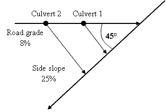 |
Figure 10:
Setup for the two cross drain experiment
|
The total sediment delivered was recorded again using WEPP:Road. All WEPP sediment-modeling parameters set in the previous experiment (one culvert scenario) were kept unchanged. The stream intersection angle ? was set at 45?. Starting with the cut-off Culvert1 in the optimal position previously determined at 60 m from the stream, the total sediment delivered was computed with Culvert 1 and Culvert 2 at several different locations. Due to the high number of possible combinations of 10m increments over a 150 m road segment only a few were fully explored. Table 1 present the results of this experiment. The sediment delivery to stream S was reduced by as much as 58 % with the cross drains at 30 and 90 m away from the stream crossing as compared to the case of a single cut-off culvert in optimal location. Other possible combinations may further improve this result. It can be inferred that the addition of a third culvert at a key location could decrease sedimentation even more.
Config.No. |
Culvert 1 |
Culvert 2 location |
Sediment Delivered |
Sediment Reduction |
(m) |
(m) |
(kg / yr) |
(%) |
|
0 |
60 |
- |
2661 |
0 |
1 |
70 |
100 |
1471 |
45 |
2 |
70 |
110 |
1497 |
44 |
3 |
60 |
100 |
1284 |
52 |
4 |
60 |
110 |
1349 |
49 |
5 |
60 |
90 |
1290 |
51 |
6 |
50 |
100 |
1217 |
54 |
7 |
50 |
90 |
1227 |
54 |
8 |
40 |
100 |
1125 |
58 |
9 |
40 |
90 |
1140 |
57 |
10 |
40 |
80 |
1219 |
54 |
11 |
30 |
100 |
1165 |
56 |
12 |
30 |
90 |
1112 |
58 |
13 |
30 |
80 |
1132 |
57 |
Full optimization of cross drain systems becomes more complex with the addition of each new culvert but the importance of the cut-off culverts closest to the stream crossing cannot be overstated. In reality, departures from the simple triangular geometry assumed here, further complicates this analysis. As road alignments and stream paths curve and weave randomly, the road’s proximity to the stream and implicitly the side slope’s filtering potential become more difficult to model analytically (Figure 11). The flow path of the water dispersed by the cross drain follows the local micro-topography and can be significantly different from the straight line distance between culvert and valley bottom. Moreover sediment generating factors, vegetation and filtering characteristics vary along the road alignment and side slope respectively adding further complexity to sediment delivery modeling.
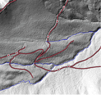 |
Figure 11: Example of a real case road
layout with culverts |
In addition to their stream crossings areas, roads are also susceptible to sediment delivery in all cases where they run parallel, in close proximity to streams (e.g. valley bottom roads). Whenever the volume of sediment diverted onto the side slope exceeds the local filtering potential, sediment delivery will occur. The process of finding best culvert locations in these situations follows similar analysis principles with the evident omission of the direct delivery from ditch component.
![]()
Computer Modeling of Cross Drain Systems
Culvert Location Analysis for Design Purposes
Optimizing cross drain culvert spacing takes into account a composite
sum of factors including terrain information, road layout, and
existing culvert locations making it difficult to be performed
by hand. As automated optimization software packages do not currently
exist designers are limited to using various sediment analysis
programs in order to estimate the validity of their design. The
investigation of best cut-off culvert location using such analysis
packages can become cumbersome and time consuming for longer
roads with multiple stream crossings laid across non-uniform
terrain. For example applying WEPP:Road for a such project requires
division of the road network into segments of uniform characteristics.
A culvert placed on one of these segments further divides the
segment into two parts: upstream and downstream from it, each
necessitating a separate run of the model. The forested lateral
buffer distance at the current culvert location has to be determined.
The simulation is run for each segment and the total sediment
delivered to stream is computed. If one or more culverts are
relocated new divisions of the original road segments and measurements
of the associated buffer length are necessary. WEPP:Road is run
over the Internet. Simulating sedimentation over short periods
of time is a relatively quick process taking approximately 1-2
seconds per road segment. However the program can only work with
one segment at a time. The manual updating of culvert positions
and dynamic segmentation of the road segments are very inefficient
and represent major drawbacks of this approach. Furthermore,
treating road segments as stand alone entities excludes any interaction
from neighboring segments. Ditch water cannot be easily carried
along different segments as encountered in reality.
The complexity of such analysis restricts its usage mostly to research
projects. The lack of an appropriate, easy to use, culvert location
analysis tool deters professional road designers and engineers
from widely devising cross drain systems for sediment reduction
purposes (Schiess, personal communication).
Interactive Culvert Placement
From the perspective of cross drain culvert design, an ideal
design tool would evaluate each design step as it is proposed
such that
a user could easily tell the effect of his/hers decision and
improve upon it. The term interactive culvert placement is
used here to
designate the process of designing cross drain systems by placing
culverts at various locations with the immediate support of a
sediment modeler to evaluate potential impacts to the nearby
streams. Decision
support tools that instantly quantify proposed alternatives typically
assist this kind of interactive design. Figure 12 depicts the
workflow of a cross drain design process using both an analysis
package
and a decision support tool.
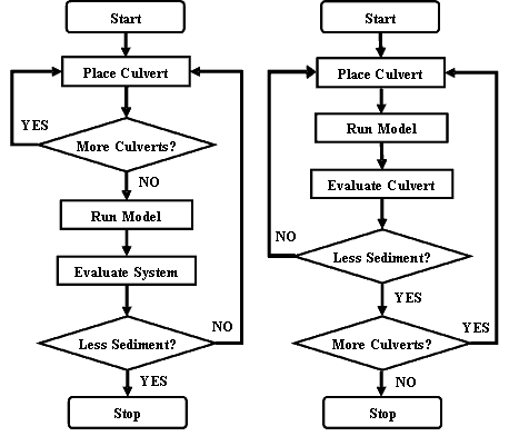 |
Figure 12: Flow chart of cross
drain design workflow; analysis tool (left), decision support
tool (right).
|
![]()
The major difference between the two cases is given by the feedback the user receives during design, as a validation of a placement decision. This feedback is essential to producing a good solution as users can quickly improve upon each proposed step and get closer to an optimum cross drain setup.
CULSED- A Decision Support Tool for Cross Drain System Design
To facilitate the investigation of sedimentation reduction from
insloped forest roads in realistic road design circumstances,
a specialized computer program named “Culvert Locator for
Sediment Reduction” (CULSED), was developed. The program
is a GIS based decision support tool focused on assisting engineers
during cross drain system design. Its primary function is to
assess the sediment delivery at each culvert location and graphically
display it on the computer screen such as users can immediately
ascertain the validity of a design decision. Using this program
it is possible to identify near-optimal cross drain locations
by exploring various permutations along the road alignment. CULSED
gives users the ability to add, move and remove cross-drain culverts,
dynamically evaluating the total sediment impact to the stream
network from the analyzed road system. Culverts can be represented
with graduated symbols proportional to their sediment delivery
(Figure 13). The question of minimizing sediment delivery is
thus transposed to a question of minimizing symbols on screen.
The total sediment delivered by the road is displayed at all
times during the analysis stages and changes with every modification
performed to the cross drain system. The program has no automated
procedures for achieving absolute minimization of total delivery
but provides the users with the means to compare culvert locations
and identify good solutions.
CULSED is implemented as an ArcGIS extension that seamlessly integrates with the standard ArcGIS package being able to access all the existing functionality and providing a familiar interface and ease of use. Running CULSED requires at the minimum a GIS road layer, a stream layer, and a digital elevation model. Additional information such as: road surface, road age, road grade, soil and parent material and side slope vegetation cover may also be used during the sediment modeling stages. Appendix A contains a more detailed explanation of this software’s capabilities.
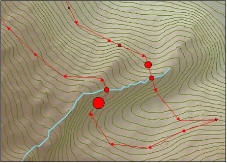 |
Figure 13: Sediment delivery
represented as proportional symbols; a minimum size symbol
represents 0 sediment delivery; arrows indicate the direction
the sediment flows along the road alignment (ditch). |
![]()
Modeling Cross Drain Systems with CULSED
The implementation of CULSED follows the well known Model-View-Controller
paradigm. The various modules composing this architecture actively
interact with each other at run time to compute and display the
sediment impact related to each user action of adding, removing
or moving culverts (Figure 14).
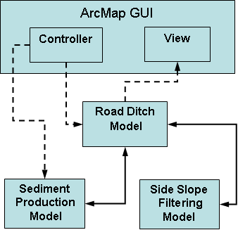 |
Figure
14: CULSED Model-View-Controller internal architecture;
dotted lines represents implicit information flow provided
by the ArcMap interface; solid lines represent explicit
information exchange between CULSED’s modules.
|
The controller module’s role is to provide user input to various operations related to the culvert analysis. It essentially drives the activities of other modules that require user interaction such as: generation of network topology, cross drain movement and description of sediment producing factors. The controller module is a part of the ArcMap user interface on which CULSED is developed.
The view module is also part of this interface and is represented by the standard ArcMap graphical output. It is at this level where the results are presented to the user for evaluation and decision support. This module receives information from the ditch model, dynamically rendering all changes made by the end user.
At the core of CULSED is a suite of three modeler modules: the Road Ditch Model, Sediment Production Model and Side Slope Filtering Model. The Road Ditch Model is a simplified representation of the road’s drain ditch, modeling the flow of water along it. This module makes the following assumptions:
- All roads are insloped
- There is continuous ditch along every road segment in the network
- Water flows along the ditch and spills out only at culverts and ditch ends
- All culverts are functioning within designed parameters
- There are no intersections of more than 4 roads
The road ditch is described by the interplay of a geometric network and its associated logical network. The geometric network stores the physical location and geometry of the roads alignments, stream crossings and cross drain culverts together with their geometric connectivity. These network components are the elements that the end user sees and interacts with on the computer screen.
![]()
The logical network portrays the sediment flow within the system,
storing the directionality of water movement. It is conceptually
similar to a generic graph, being composed of interconnected edges
and nodes. There is a direct correspondence between the elements
of the logical network and the geometric network. An edge is associated
here to a one dimensional stretch of road of uniform sediment producing
characteristics. Edges are sources of the sediment that flows along
them. A node is the abstract representation of a connection point
between edges. Culverts are always node points and play the role
of sinks within this architecture. Sinks capture all physical flow
routed to them. From a topological perspective each edge can be
characterized by parents, children, sinks and a flow direction
(Figure 15). A parent is a connected ditch segment located directly
upstream on the flow path, routing its sediment-laden water into
the current segment. For implementation reasons the maximum number
of parents is restricted to 4. Similarly a child is a connected
ditch segment downstream along the flow path, receiving sediment-laden
water from the current segment. Because in reality ditch water
is never split onto multiple roads at intersections, the model
only allows one child per segment. The presence of a sink at the
end of an edge implies no children connectivity as in reality a
cross drain intercepts and re-routs all the water it captures.
 |
| Figure 15: Logical network of the ditch model |
The Sediment Production Module used by CULSED follows the methodology outlined in the Washington Department of Natural Resources Standard Method for Conducting Watershed Analysis to compute the amount of sediment generated by the road prism (Appendix A). However, in order to provide the means for other user-implemented sediment modelers to be used with the program, this module was developed on top of a generic sediment production framework. The framework enforces a certain common functionality needed by various methodologies to work together with the other program components (Appendix B). Its main function is to calculate the sediment produced by the road prism on a segment by segment basis according to their specific sediment producing parameters. These parameters have to be associated to each road segment prior to running the analysis by the end-users unless default parameters are used.
The third module in the modeler suite, the side slope filtering module, determines the sediment filtering potential associated with each potential culvert location in road the network. It is based on the work of Ketcheson and Megahan of USDA Forest Service describing the sediment deposition on a vegetated side slope as a function of proximity to streams (Ketcheson and Megahan 1996). The module computes the proportion of sediment that can reach the stream at any given distance along a vegetated side slope (Equation 3). The proximity to the stream is based on the physical flow path distance from the culvert to the nearest stream generated from a digital elevation model.
![]()
The sediment delivered by each culvert is calculated in response to various user triggered events as the sum of the sediment produced by all contributing road segments multiplied by the filtering potential at that particular location (Equation 4).
Equation 4 Sediment delivered from each culvert. F= filtering
potential |
The total sediment delivered by the entire road drainage system is
thus given by sum of all contributing culverts (Equation 5).
Equation 5 Total sediment delivered
by road
|
Results of a Cross Drain Redesign Application
In order to proof the concept of the cut-off culvert and demonstrate its applicability in a real world case scenario, several road settings were examined within the context of a forest harvest plan. The goal of these experiments was to reduce the total sedimentation from an existing road network by redesigning its cross drain system to make better use of sediment dispersion and filtering potential on vegetated side slopes. As the cost of the resulting drainage system had not to exceed the original cost, the total number of cross drains could not be increased. CULSED was used to compute the amount of sediment delivered by the entire road network at each design alternative during the design process.
North Tahoma Planning Area
The North Tahoma State Forest is an area of approximately 25,000
acres of forested terrain on steep topography, with a well developed
road network. It is located along the Nisqually River, near Ashford
WA, contained within T15N, R6E and T14N, R6E. This site was chosen
for our cross drain design experiment due to its fragmented terrain
with many streams and road-stream crossings. A sufficient amount
of site descriptive information was available. Digital datasets
of existing cross drains, roads and high resolution digital elevation
models were obtained from WA DNR. We focused our study on Reese
Creek Watershed, a central part of the North Tahoma State Forest
(Figure 16). The existing road network in our study area was
approximately 42 miles long with 76 stream crossings. The road
grade varied between
1 and 19% with an average of 6%. The majority of roads were the
typical one lane forest road, 12 ft. width, surfaced with gravel
and maintained in good condition. As the roads were relatively
old, the side slopes were mostly re-vegetated. A cross drain
system was already in place and contained 168 culverts placed
according
to the standard WA DNR regulation. The relatively large size
of our study area and its high number of existing cross drains
severely
limited the user interaction with the dataset on the computer
screen. Therefore the site was divided it into two smaller,
more manageable
parts, based on the local topography and road structure. These
roughly equal subdivisions were named the East and West North
Tahoma respectively.
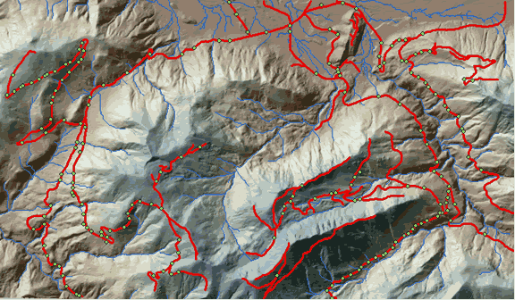 |
Figure 16: Shaded relief
model of the North Tahoma planning area; green dots represent
the original cross drain locations |
![]()
Original Sediment Delivery
The North Tahoma road network within our planning area was built
approximately 10 – 40 years ago. Some roads were converted
from older railroad grades. Its original cross drain system had
been designed to meet the specifications of the time and only
minor parts had later been upgraded to current standards. Upon
examination it could be observed that the cross drains had been
spaced at relatively uniform intervals along the road alignments,
a common practice among road engineering professionals (Figure
16). Some cross drain locations had been dictated by the terrain
features, as roads went across natural wet spots, draws, swells
or other formations that could lead to water saturation of the
road prism and cause potential road damage. They were identified
and labeled appropriately for the purpose of our analysis (Figure
17). The other cross drains had been placed according to designer’s
best judgment and experience in order to reduce ditch erosion
and maintain flow capacity.
All existing culvert locations were used as a starting point in
our sedimentation analysis.
Based on local site conditions CULSED produced an associated amount
of sediment for both the East and West halves of our planning area.
Figure 17 and Figure 18 show maps of the sediment delivery potential
in this standard configuration, represented with proportional symbols.
The total sediment delivery given by the original cross drain configuration
summed up to 67.11 tons/year. This number was computed by an empirical
sediment model based on the Washington DNR Manual for Conducting
Watershed Analysis. Although the accuracy of this model may be
debatable, it provided us with a basis for culvert location comparisons
as a relative scale to measure sediment reduction.
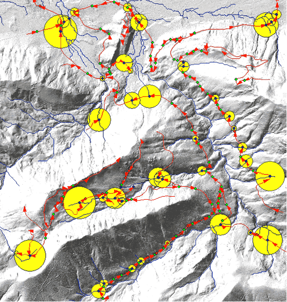 |
Figure 17: Initial
sedimentation from East North Tahoma road network – 42.10
tons/yr; blue dots represent stream crossings; red
dots represent cross drains at natural draws and wet
spots;
green dots represent other cross drains; red arrows
indicate direction of sediment flow along roadside
ditch; yellow
circles are proportional to the sediment delivered
at location. |
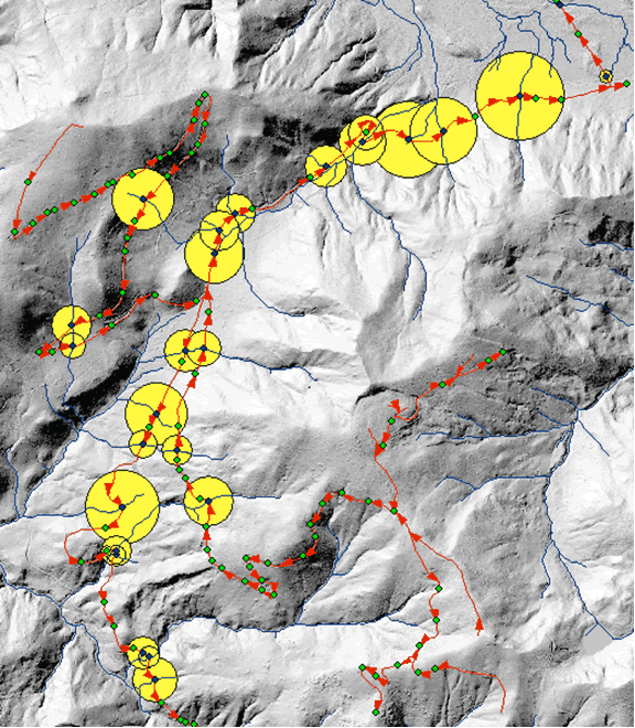 |
Figure 18: Initial
sedimentation from West North Tahoma road network – 25.18
tons/yr; blue dots represent stream crossings; green
dots represent
cross drains; red arrows indicate direction of sediment
flow along roadside ditch; yellow circles are proportional
to the sediment delivered at location; dashed bounding
box represents a subset example.
|
![]()
Design Process Example
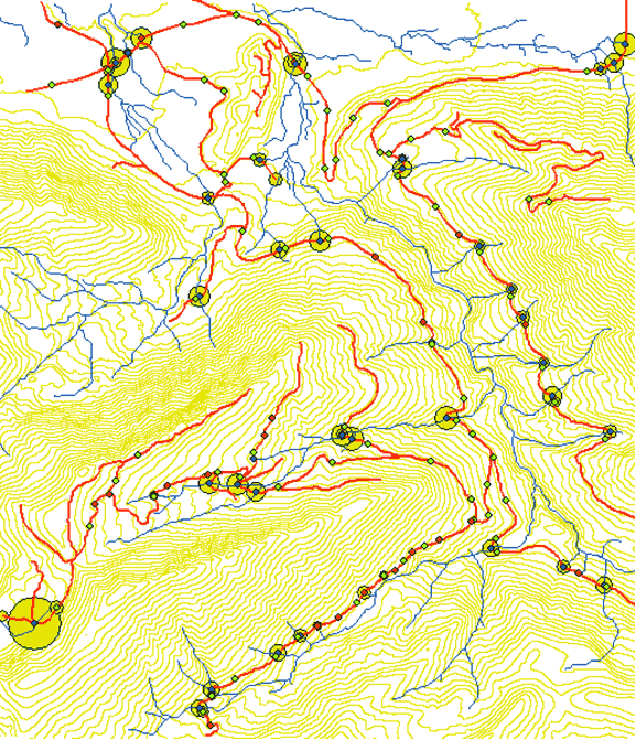
To illustrate the steps taken during the investigation of a near
optimal location for a cross drain culvert, a single stretch
of road was analyzed in greater detail. The sample road segment,
a part of the North Tahoma network, was chosen for its relatively
simple set-up (Figure 18). Starting with the original culvert
configuration, a cross drain was relocated progressively towards
the stream crossing in five iterations. Sedimentation was graphically
displayed with proportional symbols making the effects of each
of these possible culvert configurations readily apparent. The
goal of the road designer using CULSED was to minimize the sum
of sediment delivered by all culverts involved in this operation,
expressed in this case by the area of the yellow circles. Figure
19 presents the five design iterations completed in this case.
The examination of sediment delivery potential at each of the
five steps revealed a minimum at the third iteration with cut-off
culvert placed 108 ft away from the stream crossing. This is
reflected in the relative size of the graphic symbols associated
with the cross drains.
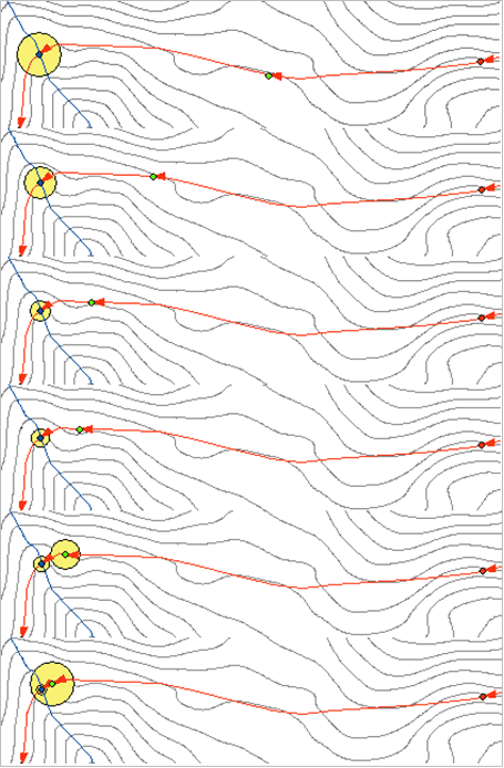 |
Figure 19: Composite
map of a culvert placement investigation process; the circle
symbols indicate the volume of sediment delivered; lowest
sedimentation is obtained at alternative 3.
|
![]()
Sediment Reduction by Cross Drain System Redesign
By applying methods similar to the one described in the “Design
Process Examples”, a number of culverts were relocated to
key locations in order to achieve sediment reduction for the entire
North Tahoma project area. The culverts originally designed for
reasons of prism health, identified and marked in the earlier steps
of our design exercise, were considered “unmovable” and
kept unchanged. The process of redesigning the cross drain system
was attempted in stages, for both the East and West subsets of
our area.
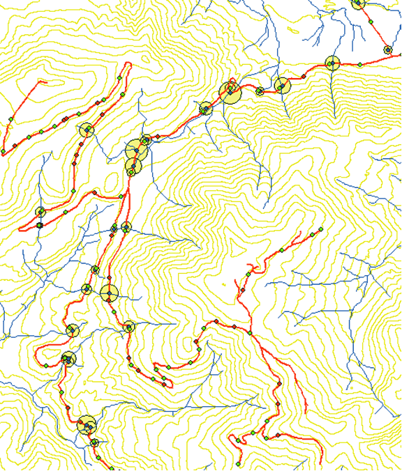
The original culvert configuration for the East half of North Tahoma consisted of 39 stream crossings, 22 unmovable drainage culverts and 64 cut-off culverts. This configuration yielded a total of 42.10 tons/year of sediment to the stream network. Acting gradually upon the greatest sediment contributors, relocating the cut-off culverts involved at each of these road settings, we were able to achieve a substantial reduction in sediment delivery. After repositioning approximately 35 cut-off culverts, the total sedimentation of the East area was reduced to 10.04 tons/year, a 76 % percent drop from the original delivery. Figure 20 displays a graphic representation of the final sedimentation. Comparing the relative size of the proportional symbols with the original configuration (Figure 17) the sediment reduction becomes obvious.
An analogous design process was conducted for the West part of
North Tahoma. The original cross drain system containing 28 stream
crossings, 27 drainage culverts and 55 cut-off cross drains, was
potentially delivering 25.01 tons of sediment / year. Redesigning
this system involved relocation of approximately 20 cross drains.
The final sediment delivery was dropped to 6.33 tons/ year, achieving
a 74 % reduction from the initial amount (Figure 21). The graphic
quantification of this improvement can be easily noticed when contrasted
with the original setup (Figure 18). The total improvement for
the entire North Tahoma planning area can thus be quantified at
approximately 75 % decrease in sedimentation. A number of 55 cross
drains have been moved to new locations. No new culverts have been
introduced in the system.
 |
Figure
20: Sediment delivery from East North Tahoma road network
after redesigning the cross drain system – 10.04
tons/ year. Yellow circles are proportional with sedimentation
at the respective location; 75% sedimentation reduction
from the original design.
|
 |
Figure
21: Sediment delivery from West North Tahoma road network
after redesigning the cross drain system – 6.33
tons/yr. Yellow circles are proportional to the sediment
delivered at the respective locations; 74% sedimentation
reduction from the original design.
|
![]()
The average distance from the first cut-off culvert to the stream crossing at the end of the design process was 140 ft. A minimum of 55, maximum of 289 and a standard deviation of 59 ft were recorded. These results contrast with the Forest Practices Board recommendation of placing the first culvert within 50 – 100 ft of a stream crossing. The wider range of values produced by CULSED stems from the variability of local conditions: sediment producing factors and delivery potential, characteristic to each road location. The interplay of the direct delivery from ditch and overland delivery from cross drain is what determines the amount of sediment reaching the streams in the near vicinity of a stream crossing. Although general guidelines can be successfully applied in certain average situations, cross-drain location design is best approached on individual bases.
One important aspect to mention is the scope of the analysis carried above. Given that an absolute optimal location is impractical to obtain through experimentation (especially when dealing with a high number of culverts over a large area) a three quarter reduction of sedimentation was considered satisfactory. Further culvert manipulation could lower sedimentation even more but major improvements should not be expected.
Weaknesses
and Shortcomings
The most important location for a cut-off culvert is within 100 – 200
ft uphill from a stream crossing, while other locations on the
road alignment can have little to no effect on sedimentation. This
is especially true on mid-slope roads situated far enough from
a stream valley to benefit from full sediment dispersion and filtering
on vegetated side slopes. In these conditions, designing a culvert
system strictly for the purpose of sediment reduction could lead
to an oversimplified drainage configuration. There is a tendency
to keep the number of culverts to a minimum as they are neutral
to sediment delivery. However, by spacing cross drains too coarsely,
long stretches of road are left exposed to ditch scouring and infiltration
of ditch water into the road structure. This may impact the maintenance
costs and potentially cause road failure as the prism and/or subgrade
reach the saturation point. The road engineer’s experience
is crucial for the outcome of such a design project.
The benefits of the cut-off culvert are more apparent in regions with steep, fragmented topography, where higher amounts of sediment are produced and transported. Flat areas with low grade roads and few stream crossings do not gain from a complex culvert analysis. Furthermore, modeling flow patterns in these flat areas presents a challenge for the current GIS algorithms, yielding unreliable results.
A particular GIS problem affecting CULSED analysis is the modeling of the flow-path and generation of streams from a digital elevation model. The raster resolution strongly impacts the outcome of this analysis. The cell spacing determines the minimum increment of the flow path distance measurement and implicitly influences the number of valid culvert locations that can be evaluated along a road segment. Analyzing short road segments with wide cell spacing can render this technique impractical. The standard 10m and 30m DEM can only be used for smaller scale analysis with a larger tolerance for error.
Specific issues related to computer modeling of the cut-off culvert concept currently restrict its wide scale usability. CULSED was designed for insloped roads with a side ditch. The ditch model assumes ditch continuity along all roads segments. A road network containing road types where the side ditch may not be present would be misinterpreted as its sediment flows would erroneously be simulated.
Sediment production and delivery potential associated with each culvert are computed with empirical models derived for particular conditions in the Northwest of the United States (WA Forest Practices Board 1997, Ketchesson and Megahan 1996). These models were meant to operate on relatively large scales and adjust poorly to the micromanaging imposed by a culvert by culvert analysis. Their absolute results may not always reflect the reality of all case scenarios met in road design. Overestimation of sediment production seemed characteristic for the North Tahoma planning area. Nevertheless, as culvert locations are evaluated on a relative scale, these figures can serve as a basis for comparison and decision support.
![]()
Discussion
Importance of Better Models
One major component of cut-off culvert modeling is the flow of
surface water from precipitation. Accumulation, canalization and
dispersion of this water drive processes of erosion, sediment transport,
deposition and infiltration into the stream networks. Cut-off culverts
together with the road ditch are directly involved in the local
hydrology as man-made structures that reroute water away from its
original pathways. To identify and estimate localized stream sedimentation
from roads, a successful model has to be able to track the flow
direction across the terrain. Flow direction constitutes the starting
point of such an analysis, a foundation on which sediment can be
associated with relevant locations within the study boundaries.
Only after the determining the flow direction can the sediment
quantification be performed. Culverts would then be spaced according
to their associated amount of sediment. This level of functionality
is supported by CULSED, a decision support tool for cross drain
design introduced above. An important enhancement to be made to
this approach is to evaluate the actual amount of water traveling
along the road’s side ditch. By knowing how much water is
accumulating at any point on a road alignment, ditch scouring processes
could be modeled. Cross drain spacing could therefore take into
account scouring in order to avoid problems related to long, unprotected
road segments. Moreover, the estimated amount of water flowing
through a particular location could serve as a parameter for dimensioning
culvert pipes. By examining an actual road set-up, existing culverts
susceptible to overflow could also be identified and marked for
a potential redesign.
Another aspect of the current method that could benefit from improvements is the modeling of the sediment delivery process from a cross drain to the nearest stream. A deterministic model of water infiltration through the forest soil has the potential to increase the accuracy of our sediment filtering prediction. Coupled with the average magnitude of water flows outwards from a specific culvert, such a model would quantify sediment deposition over distance to stream. Local terrain conditions influencing this process could serve as inputs. This model would be easily incorporated into the present GIS based analysis routines which best represent spatially distributed phenomena on a fixed point in time.
A common occurrence in GIS environmental analysis also employed
by CULSED is the use of raster elevation models (DEM) to describe
terrain features. They are in essence a discrete pixel representation
of the ground topography. In terms of pixel resolution and generating
method, various DEM standards exist but their ability to capture
topographic details varies. When performing a detailed analysis
as required by cross-drain modeling, the topographic expression
is critical to the accuracy of the results. Natural terrain features
such as small stream valleys, draws, swells and other low spots
influence local hydrology, road layout and implicitly sedimentation.
More particularly, in a computer environment they affect the modeling
of the flow path, at the base of the cross drain design process.
Recently, high resolution DEM, a new standard in terrain modeling
have been introduced. Their ability to reveal a lot of the micro-topography
makes them suitable for cross drain analysis. The North Tahoma
Redesign Project has been carried out on a 6 ft high resolution
DEM. A shaded relief of this model clearly illustrates the micro-topographical
detail included in that analysis (Figure 22). Although new, this
kind of data is rapidly becoming available at lower costs. Organizations
such as Puget Sound LIDAR Consortium are developing datasets of
large extents. As this technology matures and turns more accessible,
the usability of tools like CULSED will increase.
 |
Figure 22: Topographic detail of North Tahoma, 6ft resolution
DEM |
![]()
As with most other computer-modeling of natural phenomena, cross drain modeling needs to be validated by field verifications. Since the local conditions at various culvert locations could be complex, input parameters to the model could be erroneous or only partially descriptive. Therefore field inspections are required in order to asses both the validity of the input factors and final outcomes at project completion. The North Tahoma Project has benefited from input validation performed by University of Washington forest engineering students, class of 2003. However, as this project was investigational and will not be implemented in its current form, no further attempts of validation have been made. A future expansion of this project might take into consideration field visits and/or a monitoring program to culvert sites in the event of a possible commission.
List of References
- Burroughs E R, King J G. 1989. Reduction of soil erosion on forest
roads. U.S.
Department of Agriculture, Forest Service, Intermountain Research Station. - Elliot, W J, Hall D E, Graves, S R, Scheele, D L. 1999a. The
X-DRAIN Cross Drain
Spacing and Sediment Yield Program Version 2.00. U.S. Department of Agriculture, Forest Service, Rocky Mountain Research Station, San Dimas Technology and Development Center. - Elliot, W J, Hall, D E, Scheele, D L. 1999b. Forest Service
Interfaces for the Water
Erosion Prediction Project Computer Model. U.S. Department of Agriculture, Forest Service, Rocky Mountain Research Station, San Dimas Technology and Development Center. - Elliot W J, Hall D E, Scheele D L. 1999c. WEPP Interface for
Predicting Forest Road
Runoff, Erosion and Sediment Delivery. U.S. Department of Agriculture, Forest Service, Rocky Mountain Research Station, San Dimas Technology and Development Center. - Ketcheson G L, Megahan W F. 1996. Sediment Production and Downslope
Sediment
Transport from Forest Roads in Granitic Watersheds. U.S. Department of Agriculture, Forest Service, Intermountain Research Station. - National Center for Air and Stream Improvement. 2002. Technical
Documentation for
SEDMODL version 2. - Reid L M, Dunne T. 1984. Sediment Production from Forest Road
Surfaces. Water
Resources Research 20(11). - Schiess P, Whitaker CA. 1986. Road Design and Construction
in Sensitive Watersheds.
Food and Agriculture Organization of the United Nations, Rome, Italy. - Washington Forest Practices Boards. 1997. Standard Methodology
for Conducting
Watershed Analysis Manual, version 4. WA Department of Natural Resources. - Washington Forest Practices Board. 2000. Forest Practices Board
Manual, Section 3. WA
Department of Natural Resources. - Watershed GeoDynamics, Megahan W F, Terra GIS Solutions. 2003.
Washington Road
Surface Erosion Model. WA Department of Natural Resources.
Appendix A – CULSED Software Manual
Program Requirements
CULSED has been developed and tested for ArcMap version 8.2 on
the Windows 2000 platform. The application has not been tested
on any subsequent versions of the ESRI software.
Installation
CULSED is comprised of two ArcMap extensions currently named
RoadSedimentAnalyst and RSASedimentModel. Upon successful installation
they will show
up in the tools/extensions menu item of ArcMap. A dedicated
toolbar provided with the program will also be found in the
ArcMap list
of tools.
Installation steps:
- Download the RoadSedimentAnalyst.dll and RSASedimentModel.dll to a permanent directory on your computer.
- Use the regsvr32 application generally found at \WINNT\system32\regsvr32.exe to register these dll libraries with the operating system. You can do that by dragging the libraries onto a regsvr32 icon on your desktop.
- Run the ESRI program called Component Category Manager. It can be found in \arcgis\arcexe82\Bin\categories.exe. A screen capture of this program is seen in Figure 23.
- Highlight ESRI MX Extensions. Click “Add Object” and select the RSASedimentModel.dll from the directory where you downloaded it and click “OPEN”. Select RSASedimentModel and click “OK”. This will register the RSASedimentModel extension with ArcMap.
- Similarly to step 4, register clsExt from RoadSedimentAnalyst.dll with ESRI MX Extension. Do not register any other objects here.
- Under ESRI MX CommandBars category in the Component Category Manager register clsMenu and clsToolBar from the RoadSedimentAnalyst.dll. Do not register any other objects here.
- Register all remaining objects (except clsExt, clsMenu and clsToolBar) from RoadSedimentAnalyst.dll with the ESRI MX Commands category.
- Start ArcMap and verify that the two extensions were added
and the CULSED toolbar is available. If so you are ready to use
the
program.
 |
| Figure 23: The Component Category Manager Application for registering CULSED components |
Data Requirements
The CULSED analysis requires the following datasets:
- A hydro compensated digital elevation model. This dataset must be free of sinks and be able to derive a stream layer with the minimum contributing area method.
- A stream layer of linear features that must align with the digital elevation model. Optimally this stream layer should be generated from the DEM.
- A culvert point layer that could contain existing culvert locations. If there are no existing location the layer is still required and should be empty.
- A road layer of linear feature. The road segments should be representative of the changes in sediment producing factors (i.e. grade, width, surface material, etc.) which are given as attributes. The valid values of these attributes are given in the options menu (see below).
Software Tutorial
This section presents the tools and menu items present on the
CULSED toolbar (Figure 24).
The CULSED toolbar is composed of 9 tools and 6 menu items that operate on the existing data and control the flow of the culvert analysis session. A small window on the toolbar presents the total amount of sediment delivered by the analyzed road network at each step during analysis. The sediment volume is expressed in tons / year.
All CULSED operations must be performed within an analysis session. The session steps must be performed in order. If the session is not completed in one sitting the user can leave it open in order to be stored with the ArcMap project. When the session is stopped all progress is cleared and all internal variables reinitialized.
Note: the Spatial Analyst extension must be installed for CULSED to function properly.
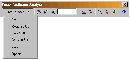 |
| Figure 24: The CULSED toolbar |
![]()
Start
This item starts an analysis session. The user is prompted to provide
the needed analysis layers (Figure 25).
 |
| Figure 25: Start menu item |
CULSED requires the following layers: a digital elevation model, a roads layer, a culvert point layer and a stream layer.
Notes: for best results the digital elevation model must be free of sinks and the stream layer must align with it. One convenient method for generating streams from a digital elevation model is the minimum contributing area method.
Road SetUp
This menu item runs a series of algorithms that setup the road
network from a geometric perspective. A road grade in percent
is estimate and stored in the road attribute table (Figure 26).
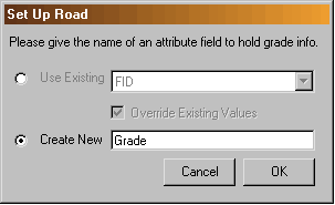 |
| Figure 26: Set up road grade menu. |
![]()
CULSED assumes that each road segment presents a consistent combination
of sediment production factors (e.g. road grade, road width, surface
material etc). At this stage in the analysis the user must examine
the road segments and ensure that this condition is met.
Because the road grade is estimated from a digital elevation model
it may not necessarily reflect the actual road reality. CULSED
provides tools for splitting and merging road segments, changing
flow direction and modifying grade.
Note: to properly estimate the road grade the vertical units of
the DEM must be the same with the horizontal units. If they differ
the user must correct the grade values in the attribute table appropriately.
![]() This
tool changes the grade of a road segment. Click on a segment to
display grade. Type a new value and right click to commit the change.
This
tool changes the grade of a road segment. Click on a segment to
display grade. Type a new value and right click to commit the change.
![]() This
tool simultaneously changes the grade of all road segments at a
certain intersection. Left click to increase grade. Right click
to decrease grade.
This
tool simultaneously changes the grade of all road segments at a
certain intersection. Left click to increase grade. Right click
to decrease grade.
![]() This
tool changes the flow direction along a road segment. The flow
direction along the side ditch is represented with arrows. Use
this tool when the DEM estimated grade is incorrect.
This
tool changes the flow direction along a road segment. The flow
direction along the side ditch is represented with arrows. Use
this tool when the DEM estimated grade is incorrect.
![]() This
tool splits a road segment in two parts. All attributes are copied
onto the newly created segments.
This
tool splits a road segment in two parts. All attributes are copied
onto the newly created segments.
![]() This
tool merges two road segments into one. The road grade is taken
from one of the segments. When more than two segments meet at an
intersection click the intersection with the left button and while
keeping the button depressed press the right button to select which
segments will get merged.
This
tool merges two road segments into one. The road grade is taken
from one of the segments. When more than two segments meet at an
intersection click the intersection with the left button and while
keeping the button depressed press the right button to select which
segments will get merged.
![]() This
command enforces geometric consistency, eliminating duplicate segments
and forcing node connectivity (simplifies geometries) to ensure
proper topology. Make sure to use this command when you are done
with all edits and are ready to proceed to next step.
This
command enforces geometric consistency, eliminating duplicate segments
and forcing node connectivity (simplifies geometries) to ensure
proper topology. Make sure to use this command when you are done
with all edits and are ready to proceed to next step.
![]()
Flow SetUp
This menu items runs a series of algorithms that construct the
internal logical network and establish the how water flows along
the side ditch. The road segments are identified as parents and
children based on their physical connectivity. All existing culverts
are snapped to the road lines and new culverts are placed at
stream crossings.
In certain cases, the network topology algorithms cannot automatically identify the parent-child relationships needed for modeling the water travel. A list of these cases is presented to the user during flow set-up. The user must click on each item on this list and using the ArcMap selection tool direct the water on its way to the next ditch segment (Figure 27).
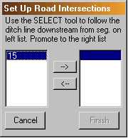 |
| Figure 27: Set up road intersections with more than one water routing choice. |
Analyze Sed
This menu item runs the sediment modeling algorithms that associate
a sediment production to each road segment and determine the
flow path distance from each potential culvert location to the
nearest stream. This module works in conjunction with the spatial
analyst extension to perform raster calculations and attribute
modifications. The sediment model is implemented as a separate
extension in order to provide interchangeability at run time.
The options menu specifies which available sediment model is
currently used.
The default sediment model provided with this version of CULSED
follows the procedures in the WA DNR Manual for Conducting Watershed
Analysis. The following sediment production parameters can be specified
as road attributes and are associated to each segment: age, grade,
width, surface material traffic and side slope cover. Other parameters
such as precipitation and parent material are considered uniform
over the entire study area (Figure 28). If no attributes fields
are specified, a set of default road characteristics are applied.
The can be viewed and modified in the option menu.
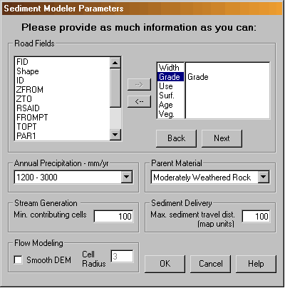 |
| Figure 28: Sediment modeling parameters. |
![]()
A minimum number of contributing cells is required for computing the flow paths to the nearest streams. A raster layer of streams is generated during this process. For accurate results this number should produce a stream layer identical to the one used in the input section.
The flow modeling section is useful when working with high resolution elevation models. A typical problem when modeling water flow in these cases is the stream capture by the road ditch. To reduce the stream capturing effects the elevation models can be smoothed with a circular neighborhood of given radius.
The maximum sediment travel distance represents is a generic number that influences the sediment deposition factor used for calculating a probability of sediment delivery. This number is particular to local conditions and should be based on empirical observations at the site. The user’s expertise is important for obtaining valid results.
Culvert Operation Tools
A set of tools that allow insertion, relocation and removal of
cross drain culverts is provided. These tools only become available
after the sediment analysis has been performed. Operating any
of these tools triggers recalculations of sediment delivery probability
and summation of total sediment delivered by the road network.
These changes are reflected in the sediment window.
![]() This
tool inserts a new cross drain in the road drainage system.
This
tool inserts a new cross drain in the road drainage system.
![]() This
tool moves a cross drain culvert to a different location.
This
tool moves a cross drain culvert to a different location.
![]() This
tool removes a cross drain from the road drainage system.
This
tool removes a cross drain from the road drainage system.
Stop
Stop an analysis session and clears all variable. Use only when
a session is completed.
Options
The options menu presents specifies the sediment model to be used
and give the default road characteristics for sediment production
calculations.
A new ArcMap extension must be developed in order to use a different sediment model. This extension must be written in Visual Basic and must implement the ISedimentModel interface provided with the CULSED code (Appendix B). This interface specifies the methods necessary for CULSED to be able to integrate with a sediment model.
![]()
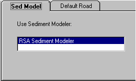 |
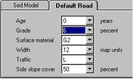 |
| Figure 29: Option menu. Default Sediment Model (left), Default Road (right). | |
Workflow Example
Following the steps in the program’s main menu (see above)
in the order they are given guides the user through a CULSED session.
The following images are screen capture of a typical CULSED session.
After inputting the required layers at the start menu the user must proceed to set up the road geometry (if needed) by estimating and adjusting grades and inspecting road attributes that drive sediment production (Figure 30). At this stage it is helpful to display the road grade associated to each segment.
The next step is to generate the road network topology. The user
may be asked for sediment routing information in cases where two
or more possible flow paths exist. Upon successful completion the
road network is ready to be analyzed for sedimentation (Figure
31).
Special note regarding switchbacks:
CULSED does not automatically account for the “ditch-out” normally
present at switch back. To prevent the program from carrying
the water onto around the switchback the user must represent
the ditch-out by placing a cross-drain at the center of the switchback.
This cross drain is generic and can be flagged in the attribute
table for later identification.
Once the sediment analysis has been run, an amount of sediment
delivered will be associated to each existing culvert.
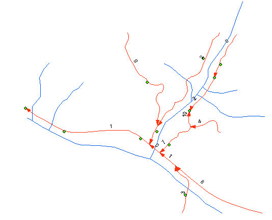 |
| Figure 30: Road Geometry Setup has been run. A road grade is computed. The user splits segments and changes all incorrect grades appropriately. |
![]()
To take advantage of the intended graphic comparison the used must draw culverts with proportional symbols based on the field called “SED” in the culvert layer’s attribute table. If these values are spread over a wide range it is helpful to “stratify” the analysis and start by representing only the big contributors. As sedimentation is reduced by moving culverts to different locations culverts in the lower sediment ranges can also be included (Figure 32). Most of the sedimentation will be located near the stream crossings and it is these locations where users can make the greatest improvements to their drainage systems.
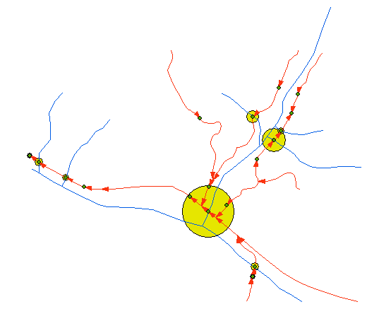 |
| Figure 31: Flow Setup and Sediment Analysis have been run. The existing culverts are snapped to roads, culverts are automatically placed at stream crossings and a volume of sediment delivered is associated with each culvert. The user places cross drains to reduce sedimentation. |
![]()
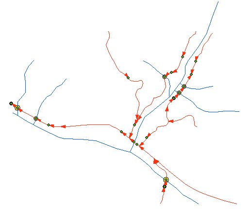 |
| Figure 32: Culverts have been moved to near optimal locations. Sedimentation is reduced. |
![]()

