 |
 |
 |
 |


GIS Software Overview
Delorme
XMap® Product Family ($350 or more, depending on modules)
|
||||||||||||||||||||||||||||||||||||||||||||||||||||||||||||||||||||||||||||

| Delorme's software offers a tightly integrated
combination of maps, trip planning functions and GPS tools.
Its XMap family is a "modular" GIS, allowing users
to focus on the elements they need without being distracted
by those they don't. Delorme data for XMap comes ready-to-use,
requiring minimal knowledge on the user's part about projections,
datums and other technicalities. The resulting XMap system is
unbeatably simple to operate.
There are a number of products that make up the XMap family
(see information about a pending release
of XMap 4.0 below). The ones considered here include: |
| Product |
Function |
Cost |
| XMap® 3.5 |
Basic Mapping Engine | $99.00 |
| - Image Registration Module | Needed to import digital or scanned aerial photos or maps | $149.95 |
| - Export Module | Saves geo-referenced images for use in other GIS programs | $399.95 |
| Topo USA® 4.0 |
Includes most of the XMap engine plus detailed vector roads/streams/boundaries and elevation data for the entire US | $99.95 |
| Street Atlas USA® 2003 Plus |
Includes most of the XMap engine, US vector roads/streams/boundaries plus the ability to import geocoded database files | $99.00 |
| 3D TopoQuads® 2.0 (*per
state/region) |
Includes most of the XMap engine plus USGS digital raster graphic (DRG) topographic maps | $99.95* |
| Sat 10 Satellite Imagery (*per
state/region) |
10-meter resolution colorized SPOT satellite images for use in XMap 3.5 or Topo USA | $99.00* |
| Each of the products listed in bold include
all the map drawing features found in the core XMap 3.5 engine.
The primary difference is that XMap 3.5 will import point/line/area
shapefiles from other GIS programs and will export DXF vector
files. The shapefile import feature makes it possible to bring
in valuable information like public land survey section lines
and section corners for use in XMap projects. Also, only the
standalone version of XMap 3.5 accepts the image registration,
export and other optional modules. The XMap 3.5 engine does
not include any base maps. It must be used in combination Topo
USA or 3D TopoQuads. (A good basic combination - highlighted
above - would be XMap 3.5, the Image Registration Module and
Topo USA for about $350 total.)
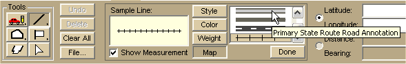
XMap 3.5 limits the types of geographic data that it imports. It cannot, for example, directly utilize DLG or SDTS vector data (but you could use a program like Global Mapper to translate data into shapefile format for use by XMap). Even if you have orthophotos or other digital image files that are already geo-referenced, XMap cannot make use of them unless you bring them in through the Image Registration Module. XMap converts imported data into proprietary files that can be used directly only by XMap. If you want to use your work in other GIS programs, you can export DXF files for the vector drawings. You would need to purchase the Export Module to save GeoTiff or other geo-referenced image formats. The tradeoff in file import options is compensated by the almost effortless creation of base maps. If you are uneasy about projections and coordinate systems, XMap can handle those details behind the scenes if you stick to Delorme data. The drawing functions for adding your information to the base maps are straightforward. The basics can be learned in about a half-hour of experimentation and reading. (The entire user manual is only about 150 pages.) XMap has a basic drawing pallet. Shown here are a few of the line choices: |
| Four of the tool buttons on the left of the palette expand.
Use these tools You can start a new map object by copying a segment of an existing road, trail or other built-in vector feature. You actually select and then promote a copy of the base map component into a new drawing layer. Once there, you can edit the object or use its vertices as snap points. Drawn objects are very easy to align with the snap feature. As you approach a control point that can be snapped to, it turns yellow. Snap is always enabled unless you hold down the control key. You can precisely position any of your drawing objects with latitude/longitude and bearing/distance placement controls as well. |
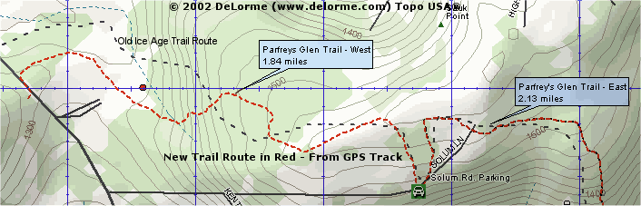
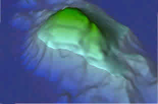
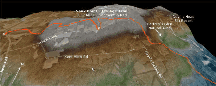
| If you own a laptop PC and a GPS unit, the XMap programs have moving map features so you can track your position in real time. The programs provide audible guidance if you are following a planned route. You can use XMap to manage your waypoint, route and track files and transfer data to and from most GPS units. Your GPS data is displayed in either 2D or 3D drawing layers. The 3D image to the right shows tracks (in red) of a couple hikes at Wisconsin's Devil's Lake State Park. The map at the top of this section shows the path of a re-routed Parfrey's Glen - Ice Age Trail at the park in red, established with a GPS track and waypoints (the old trail is in black). | 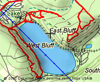 |
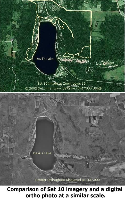
| Sat 10 images (10-meter resolution SPOT satellite
pictures) are available for XMap and Topo USA at about $100
per state/region. Click
here to see a 2D Sat 10 example with the GPS track overlay.
The images are clear to about a 13 zoom factor. Any closer,
and you might need a higher resolution image.
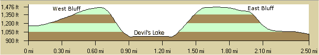
Topo USA comes with a free ~40 square mile download of a Sat 10 image of your choosing through XMap's NetLink tool. When you draw on a Sat 10 image, the object appears automatically on the colored base map in a split-screen window. That makes it easy to trace features from the satellite image to the base map. Delorme might offer higher resolution photos in the future through NetLink. Another helpful feature of XMap (Topo USA in particular) is the profile tool. Draw a line on the map, select it, and then choose the Profile Tab. You'll see the elevations along the line: |
| If you would like access to a geocoded US telephone
database ($50 more) or have your own point data (with latitude/longitude
coordinates, zip codes or street addresses), then Street Atlas
USA 2003 Plus is the ticket. With the optional telephone number
data set, you could (for example) search to find everyone who
lives within a given radius of a fixed point or within a certain
block. You can utilize US census data in searches. You can also
link other files such as photographs or URL's to map points.
Even if you work with a comprehensive GIS like Manifold or ArcView, you'll probably at least want Topo USA 4.0 on your desktop. It's a superb complementary mapping program, quickly enabling you to scope out fieldwork sites or to view your GPS tracks and waypoints. Visit Delorme to discover more or to purchase the products. The user manuals for all the Delorme XMap products are available for download. Note: Delorme announced the release of XMap 4 in late February 2003. Based on the promotional material, it will include a database import wizard, data mapping and document linking functions similar to those offered in Street Atlas USA Plus. Delorme will be expanding the option to purchase custom, downloadable map data packets that include USGS DOQQ, DRG, DEM, and Sat 10 satellite imagery. The price of XMap 4 will be $199. Image registration and export modules will be continued as add-ons. |
Map Maker Pro ($330)
 |
|
| Map Maker Pro 3.5 is an outstanding, forestry friendly GIS program. The system is uncomplicated and well tailored to making resource management maps or analyzing spatial data. A description of the Gratis version of Map Maker is available in the Toolbox. |
| You might wonder, "Do I really need the
Pro version?" since Map Maker Gratis is available free.
If you are a casual GIS user making a limited number of maps
with a well-defined set of photos and vector data, Gratis is
an able map creation tool (and certainly a generous gift). If,
however, you are a professional resource manager routinely creating
maps, analyzing spatial databases, integrating GPS, combining
images and vector layers from many sources or doing other complex
GIS tasks, then Map Maker Pro would be a sensible choice.
A partial list of features above and beyond those offered in Map Maker Gratis include: |
| Map Creation • Single-click flood-fill vector polygon creation • Raster and vector rubber sheeting • Create buffer zones around collections of objects • Trim raster and vector to polygons • "Spaghetti processing", - lines to polygons • Intersections and unions from overlapping polygons • Powerful data tidying routines • Raster to vector • Rubber sheeting of vector and raster data |
Map Projections/Coordinate
Systems • UTM, OS Grid, Lambert’s Conic, and user-defined Transverse Mercator and Conic projections • 225 pre-defined datums, limitless user definable datums and ellipsoids |
| GPS Tools • Live data capture (NMEA and Garmin) • Download waypoints and tracks • Live tracking of moving points • Ortho-rectify aerial photography using GPS control points |
Data Export • Export SHP, MIF, DXF etc • Export BMP, JPG, TIF, Geo-Tiff, and ECW images |
| Spatial Data Analysis • Use data from Microsoft Access, Excel, or dBase files to make thematic maps • Generate legends automatically • Link data queries seamlessly to Microsoft Access forms or Lotus Approach Forms • Complex spatial queries |
3D Mapping • Create surfaces, perspective views, elevation profiles and contours; calculate volumes and many more functions |
 |
For additional information, visit
the
Map Maker North America site for a tour of the product.
Click the image to the left to see a gallery of 2D and 3D
maps produced by Map Maker Pro. The 3D gallery at Map Maker
includes a few intriguing
annimations.
Try Map Maker Pro yourself. It's available as a free 30-day
trial. The 257 page Pro manual and 72 page 3D manual are excellent
guides. Download the program and documentation from Map
Maker North America or Map
Maker UK. |
| (Copyrighted 3D image used courtesy of Map Maker North America LTD) |
Manifold System 5.5 Professional® ($245)
| Manifold System 5.5 is a full-featured, industrial strength Geographic Information System. Manifold imports most image and vector data and has exceptional drawing tools, resulting in accurate and attractive maps. It lets you incorporate the scanned |
| aerial photos and paper maps in your archives with intuitive image rectification and geo-referencing features. The program's image editing capabilities rival dedicated programs like PhotoShop®. You'll also be able to dig into spatial data with a powerful SQL database engine. |
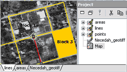 |
Manifold utilizes simple, project-based organization. You first open, import or create layers in the right project window. Click and drag elements from the project window into a map pane on the left to compose a map view. Tabs at the bottom of the view show which elements are active. You can also edit a particular project layer in isolation by double clicking on it. Manifold works with over 80 different file types, and so you can exploit mapping information from almost any source. |
| Manifold Professional Edition's basic approach to project storage is to combine all the elements including imported vector, raster and tabular data along with new layers you create into one container file saved with a "map" extension. The container file approach has its benefits, keeping all the parts of a project together. That makes it easy to move work between computers. The project-based approach also lets you define as many views (maps) as you like, combining and mixing the elements of the project. Each map view takes very little space in itself, but the container file approach can result in duplication of data on your hard drive. The alternative is to have Manifold link to files left on their DBMS servers, allowing unlimited-sized projects. The Enterprise Edition of Manifold (only $395) offers additional file linking options. Manifold is built around a SQL engine as powerful as other standalone database programs that cost twice as much. If you are a professional resource manager, your organization probably has a wealth of inventory or reconnaissance data from decades of fieldwork. Manifold can easily bring that data into a project, link it to areas on maps and help you look at it in new ways. You can also employ Manifold's SQL engine to independently analyze data without any map associations. |
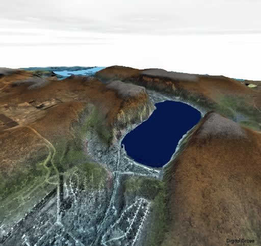 |
The 3D surface visualization capabilities in Manifold are impressive. Click the image on the left for a sample combining a USGS DEM and a 2D gray scale orthophoto. Manifold will also overlay vector data on the 3D surface as shown in the trail map above. (Click the image for a larger view to the southwest. The trail in red is a GPS track saved as a shapefile in OziExplorer and imported into Manifold. This is the same trail shown at the top of the |
| Delorme XMap section.) If you intend to do much 3D visualization, get a GeForce4 64MB or larger 3D graphics processor for your PC. With a graphics accelerator, you "fly" effortlessly over your terrain even at full resolution. With the prevalence of MrSID® format imagery from many natural resource agencies, you might wonder about the absence of direct support for compressed MrSID imagery in Manifold. It's definitely not for lack of technical know-how. Manifold apparently has concerns about the proprietary nature of the MrSID format and has instead opted to focus on alternatives like ECW compression. Although somewhat inconvenient, you must first extract an area of interest as a GeoTIFF file with a separate utility like MrSID GeoViewer in order to use MrSID data with Manifold. (The same limitation regarding MrSID imagery also applies to XMap and Map Maker.) Can you teach yourself to use Manifold? Yes, but the experience can be taxing at times considering Manifold's sophisticated capabilities. The online manual is extensive at 3,000+ pages. You don't need to read (or print) the whole thing, though, to get going. There is a good selection of examples to follow. A concise quick-start guide that could be conveniently printed and more online training tutorials would, however, be desirable additions. If you do not need the power tools offered by Manifold, you might want to consider very capable but easier to learn programs like MapMaker Pro or Delorme XMap. In my experience, Manifold is the most complex of the three. MapMaker is intermediate, while XMap is the simplest to learn. Manifold is also the most demanding of system resources of the three GIS programs listed here. Be sure to compare your computer assets to system requirements before making a purchase. The fabulous $245 Manifold price includes two incidents of free technical support. Additional support can be purchased if needed at the Manifold online store. Another source of help is the Manifold discussion list hosted by Directions Magazine. In addition to finding answers to questions, many of the list users post helpful procedures, scripts and tips. To learn more about Manifold, see the review written by Paul Amos featured at Directions Magazine. The entire Manifold user manual and a complete product description are also available on the Internet. There is no trial version of Manifold System 5, but the company gives a 30-day money back guarantee. (Initially, the program runs for up to 30 days with an included serial number. As long as you do not download a registration key in that time, you can return the product. Manifold is confident, for good reason, that you will not be making a return.) Useful Manifold 5.5 Links:http://www.manifold.net/products/mfd50pro/55_highlights.html For a comparison between the Manifold 5.50-geocoder combination ($50 extra) and a competitor's $9,000 product see: http://www.manifold.net/products/geocoder/geocoder_comp_home.html |
| As a final note, even if you use GIS programs like those above, you will find many stand-alone mapping programs to be invaluable. Commercial, registered versions of products described in the Mapping Toolbox are first-rate. You would also not want to be without many of the free software titles included there. |

