|
 |
 |
 |


Image Rectification
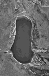
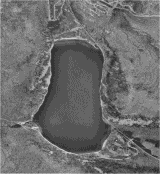
Why Rectify?Coordinates, distances and areas measured on a rectified orthophoto will be the same as on the ground. That is vital if you plan to use scanned images in geospatial mapping programs (but not critical if you only intend to use aerial images in simple drawing programs). One of the advantages to using TerraServer digital orthophotos for base maps is that they have already been geo-referenced and rectified. TerraServer images, however, might not always be adequate for resource management projects. They might be too old. They don't show the forest during the growing season, and so hardwood tree species are difficult to distinguish. You can't use TerraServer images under a stereoscope. For these and other reasons, you might choose to acquire conventional aerial photography for base maps. Conventional photos can be easily scanned if you want to make digital maps. With the rudimentary geo-referencing procedure described previously, you could create a world coordinate file for the scanned image. But will the image line up with other geographic data? Only if you are very lucky. Tilt of the aircraft, lens distortion, scanner distortion, natural perspective and topography can all effect the appearance of features in a scanned photo. Of the two lake photos below, which is the true image?
Actually, both of them are. They are just displayed in different map projections, which is another factor to consider when scanning an aerial photo. There are specialized software programs that rectify aerial photos, removing distortion and projecting the image according to a selected coordinate system. They all rely on Ground Control Points (GCP), whose geographic coordinates are know from previous rectified maps and photos or which are determined by precise GPS readings. In one method (polynomial approximation), GCP locations are identified on the photos and the projection grid. The computer software will morph the image to align control points on the photo to the grid. In another method (orthorectification), a Digital Elevation Model (DEM) is also used to remove perspective-related distortion caused by topography. There are a couple free trial programs using polynomial approximation that you might want to download and explore. TatukGIS® offers their Aerial Imagery Corrector (AIC) on a free 30-day trial. AIC (about $200) is a dedicated rectification/projection program with many refinements that make it easy to use. The trial package has a detailed, educational help system. Another free 30-day trial choice is Map Maker Pro (about $330), which can rectify photos in addition to its comprehensive mapping and GIS functions. Manifold GIS is another low-cost option ($245). If you wish to research other commercial imagery rectification products (some offering orthorectification), here are a few to consider:
|