
forestandrange.org home || learning options || further assistance
Lesson 4: Establishing Fixed Plots
Review and Introduction
In earlier lessons, you mapped out your stands, identified where plots will go, and navigated in the woods to your first plot location. This lesson will teach you how to establish a fixed area plot. In Lesson 5, we will talk about a different kind of plot, which is a variable area plot. As a reminder, you are sampling your stand using plots, so that you can extrapolate the data collected to the full stand on an acre basis.
Learning Objectives:
By the end of this lesson, you should be able to:
- Determine the appropriate plot size
- Establish the boundary of a fixed plot
- Identify and count “in” trees (sample trees)
- Understand the relationship between the number of trees in the plot and the number of trees in the stand on a per acre basis
Materials Needed:
- Measuring tape or logger tape
- Colored survey ribbon
- Orange timber marking crayon (optional)
- Permanent Marker (optional)
- Rope (optional)
I. Plot size
Just as it sounds, a fixed area plot is a plot with a known area. When you establish the first plot in any given stand, you will need to choose an appropriate plot size. This size must then be used throughout the rest of the stand. You will want to choose a plot size that will give you, on average, 5–10 trees per plot. Try a starting plot size, such as 1/20th of an acre, and see if you get in the neighborhood of 5-10 trees.
If you find that the trees in your stand are widely spaced such that you have very few trees in your plot (4 or fewer) and this wide spacing looks to be consistent throughout the stand, you should consider increasing your plot size (e.g. 1/10 acre). Similarly, if your stand is dense such that you have numerous trees (12 or more), you might consider something smaller (e.g. 1/30 acre).
II. Establish the boundary of your fixed plot
Plots can be established in various shapes—square, rectangular, or circular. For ease of use, circular plots will be addressed. To establish your circular plot, you will need to know the plot radius, which is the distance from the plot center to the outer edge of the plot (Figure 4-1). Table 4-1 below shows plot radius values for a range of plot sizes.
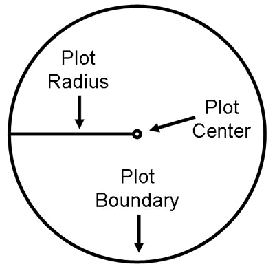 |
| Figure 4-1: The plot radius is the distance between the plot center and outer boundary of the plot. Table 4-1 lists plot radii for different sized plots. |
To establish your plot boundary, walk out the prescribed distance in various directions and hang a colored survey ribbon on a nearby branch or shrub to mark the plot boundary. You should go out at least six different directions to get a good sense of where the plot boundary is. Once you have six or more flagged points marked around your plot boundary, you will need to visually “connect the dots” to estimate the complete boundary of your plot.
Table 4-1: Plot radius values for different sizes of fixed, circular plots.
Plot Size (acres) |
Radius (feet) |
1/5 |
52.7 |
1/10 |
37.2 |
1/20 |
26.3 |
1/30 |
21.5 |
1/40 |
18.6 |
1/50 |
16.7 |
When measuring out the distance from your plot center to your plot perimeter, you can use a cloth measuring tape or a logger tape. You can also use a rope that has been pre-cut to the length of your plot radius. This may save time and effort in marking your plot perimeter. It is very helpful to have two people when establishing a fixed plot—one person to hold the rope or measuring tape at plot center while the other person carries the other end to mark the plot boundary.
![]()
Watch a video clip of how to establish a fixed area plot
III. Determining “in” trees
Now that you have marked the boundary of your plot, you will need to determine which trees are in the plot. A tree is considered “in” if the center of the tree falls within the plot boundary. Starting from a given direction (either north or the direction you traveled to get to the plot), systematically work your way around the plot in a clockwise direction and identify your in trees. It may be helpful to flag these trees with colored survey ribbon as you go. You can use a permanent marker to number the flags to help you keep track of each tree. You can also use an orange timber-marking crayon to mark/number your in trees.
When identifying trees in your plot, there should be a minimum size limit. For the purposes of this learning module, we will focus on overstory trees, which we will define as live trees with at least 1” diameter at breast height (DBH) (more on this in Lesson 6). Snags (dead trees), smaller trees, and other features of the stand may also be of interest to you, depending on your management objectives and the purposes of your inventory. There are techniques to inventory these features, but those are beyond the scope of this learning module.
You may run into the issue of borderline trees, whose center falls directly on the plot boundary. A true borderline tree is rare—you should be able to make a reasonable estimate of whether the tree is in or out in most cases. If necessary, run the tape or rope from the plot center directly to the tree to determine whether the center of the tree falls inside or outside the plot boundary. Figure 4-2 shows a schematic of a fixed plot with in trees identified in blue.
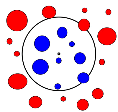 |
| Figure 4-2: A schematic of a fixed area plot. In (sample) trees are identified in blue, and out trees are shown in red. Trees that fall along the plot boundary are determined as in or out based on whether the center of the tree falls within the plot. |
IV. How do plot trees relate to the larger stand?
An advantage of fixed area plots is that the relationship between a plot tree and the larger stand is straightforward. For example, a tree in a 1/20th acre plot would represent 20 trees per acre (TPA) in the larger stand. This is also referred to as the tree’s expansion factor. The expansion factor becomes slightly more complicated when you have multiple plots in a stand, as you must divide the expansion factor for one plot by the total number of plots.
Example:
Suppose you put in 10 1/20th acre plots in a stand. Each plot tree represents 1 x 20 / 10 = 2 trees per acre in the stand (i.e. an expansion factor of 2). Stated in a different way, since you sampled ten 1/20th acre plots, you sampled a half acre. Thus to determine acre values, multiply each sample tree by two.
|
Next Steps:
- Test your knowledge by taking a Short Quiz.
- Go to the Next Lesson.