|
 |
 |
 |


Working Paper 1
Economic Impacts of the Forests and Fish Rules
on Small, NIPF Landowners
|
 |
| Figure i. The FFR buffers for Western Washington. |
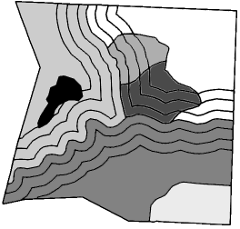
The economic impacts of these buffers can be particularly burdensome for small forest landowners. Larger landowners can average their impacts over a large area (Figure ii(a)), but with small ownerships the impacts of buffers are concentrated on smaller areas (Figure ii(b)). This suggests that the impacts to small landowners are likely to be highly variable, as those with streams on their property may experience high impacts while those without streams may not be impacted at all.
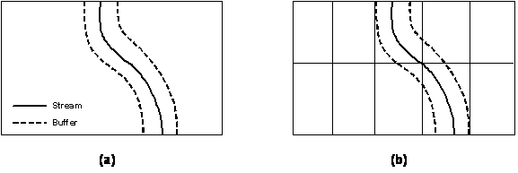
| Figure ii. | With large ownerships, buffer impacts can be averaged over a large area. With small ownerships, buffer impacts are concentrated on smaller areas. |
![]()
The purpose of doing case studies is to better understand these issues of variability and disparity and to see how individual landowners are impacted by the rules. Cases studies also offer opportunities to compare impacts between different management options. We looked at the extent to which the economic impacts would be reduced by doing the maximum allowable partial harvest in the riparian zone compared to treating all three zones as a no harvest area, which is the strategy chosen by most small landowners who have harvested under the FFR.
We also looked at the extent to which economic impacts would be mitigated by participating in the Forestry Riparian Easement Program (FREP). The FREP was established along with the FFR to help offset the cost of the new riparian buffers to small landowners. Landowners who participate in the program are given cash compensation at the time of harvest for a portion of timber value that must be left in riparian buffers. If the value of the required riparian leave trees amounts to 19.1% or less of the total harvest value, then compensation is given at 50%. If the value of required leave trees exceeds a high impact threshold of 19.1% of the total harvest value, 50% compensation is given for the first 19.1%, while full compensation is given for the remaining value in excess of 19.1%. Participation in the FREP places a 50-year easement on the required leave trees.
METHODS
To demonstrate the use of technology in addressing
complex forestry issues, the latest computer software tools were
employed to do the case studies. Spatial data for each case study
was compiled using Geographic Information Systems (GIS). This
data was then combined with forest inventory data in the Landscape
Management System (LMS), a program developed at the University
of Washington that integrates a suite of tools such as growth
models and forest visualization programs. Using LMS, management
simulations were done under the previous rules and then under
the new rules. The harvest outputs from LMS were then put into
spreadsheets for economic analysis.
Several criteria were used to evaluate the economic performance
of the new rules relative to the previous rules for each case
study. The first criterion was forest value, which represents
the total value of a forest as an economic asset. This is the
economic value of both the currently standing timber and the land
on which it stands given a target rate of return, which was a
real 5% for this study.
Land value (also called land expectation or soil expectation value)
was then separated from forest value and used as an additional
criterion. Land value is the residual value that remains after
the existing timber is harvested, and it is based on the economic
potential for producing timber rotations in perpetuity when starting
from bare land. Land value is of particular interest because it
demonstrates the economic performance of beginning a new rotation
once the existing rotation is complete. Thus, it represents the
economic potential for sustainable forest management.
RESULTS
The results of the case studies are plotted in Figure iii as a
percent change in value relative to the previous rules (the permanent
rules that were in place before the FFR). The forest value losses
are most severe if no riparian harvest is done, treating all three
zones as no-cut areas. The impacts from that scenario range from
a best case 23% loss to a worst case 54% loss. If the maximum
allowable harvest is done in the inner and outer zones for each
case study, impacts range from a 17% loss to a 35% loss in forest
value. If the maximum allowable riparian harvest is done and each
landowner participates in the FREP, impacts range from a 1% loss
to a 12% loss.
The impacts on land value are more severe than impacts on total
forest value. If no riparian harvest is done, impacts range from
a best case 29% loss to a worst case 115% loss. If the maximum
allowable riparian harvest is done, impacts range from a 21% loss
to a 92% loss. Losses greater than 100% indicate that the target
rate of return can no longer be achieved.
| Figure iii. | Percent change in forest value and land value under the FFR relative to the previous rules for ten Western Washington case studies. |
![]()
DISCUSSION
The results of these case studies support the idea that the economic impacts to small landowners from the FFR are highly variable and that the impacts will be severe for some landowners. The impacts are most severe if no harvest is done in the riparian zone. The results suggest that landowners can reduce their losses by doing the maximum allowable riparian harvest. However, even with maximum riparian harvest the losses are still substantial in some cases. Part of the reason that maximizing riparian harvest does not do more to minimize impacts is that calculating the allowable riparian harvest requires additional cruising and layout costs that offset any value recovery.
It appears that land value is particularly diminished by the new rules, with some case studies losing most or all of their land value. Land value is lost in no-cut areas such as the core zone and parts of the inner zone, as the permanent retention of these trees precludes the use of the land for growing future timber rotations. If a significant portion of a given property is taken out of production because of buffer restrictions, it makes the entire property unprofitable in some cases, as there is now a much smaller production base to cover fixed overhead costs. Fragmentation may also make management unfeasible for the entire property in some cases. Significant decreases in land value imply that continued forest management will no longer be economically viable for some small landowners under the FFR. This will likely result in unintended consequences such as increased land use conversion.
The results show that the FREP can be very effective at mitigating impacts. If each case study participated in the FREP, the magnitude and disparity of forest value losses would be significantly reduced. Part of the reason the FREP is so effective is that the 19.1% high impact threshold limits losses to a maximum of 9.55% of the total sale (50% of 19.1%). Since the timber qualifying for compensation under the FREP includes timber that had to be left under the previous rules, landowners can actually have a gain in forest value relative to the previous rules in some cases. The FREP also compensates for the extra layout costs associated with harvesting in the riparian zone, making it more economical to do the maximum riparian harvest.
Unfortunately, current funding levels for the FREP fall well below the level required for large-scale participation, and future funding is uncertain. Consequently, the majority of small landowners will not be able to benefit from this program. Also, the FREP only compensates for standing timber; it does not compensate for the land on which that timber stands. Thus, it does not mitigate for losses in land value or address the associated long-term sustainability issues.
Additional work is being done to examine potential
alternate plans that would provide equivalent protection of aquatic
resources while minimizing economic impacts to landowners. Case
studies for Eastern Washington have also been completed, raising
different management questions. Those results are reported separately
(Oneil 2003).
TABLE OF CONTENTS
***(Read, save or print the PDF of this Report!)***
ACKNOWLEDGEMENTS
EXECUTIVE SUMMARY
TABLE OF CONTENTS
LIST OF TABLES
LIST OF FIGURES
LIST OF EQUATIONS
| 1.0 | INTRODUCTION |
| 2.0 | BACKGROUND |
| 2.1 | THE FORESTS AND FISH RULES (FFR) |
| 2.2 | MITIGATION OF ECONOMIC IMPACTS |
| 2.3 | WHY THE CASE STUDY APPROACH |
| 3.0 | METHODS AND ASSUMPTIONS |
| 3.1 | CASE STUDY PARTICIPANTS |
| 3.2 | MODELING |
| 3.3 | MANAGEMENT SCENARIOS |
| 3.4 | ECONOMIC ASSUMPTIONS |
| 3.5 | ECONOMIC ANALYSIS |
| 3.5.1 | Land Value |
| 3.5.2 | Forest Value |
| 3.5.3 | Forest value with the FREP |
| 4.0 | CASE STUDY RESULTS |
| 4.1 | IMPACTS ON FOREST VALUE |
| 4.2 | IMPACTS ON LAND VALUE |
| 4.3 | IMPACTS OF MITIGATION |
| 5.0 | DISCUSSION |
| 5.1 | ECONOMIC IMPACTS AND MANAGEMENT OPTIONS |
| 5.2 | EFFECTIVENESS OF MITIGATION |
| 5.3 | BROADER IMPLICATIONS |
| 5.4 | FUTURE RESEARCH |
APPENDIX A: INDIVIDUAL CASE STUDY RESULTS
| A.1 | CASE STUDY 1 |
| A.2 | CASE STUDY 2 |
| A.3 | CASE STUDY 3 |
| A.4 | CASE STUDY 4 |
| A.5 | CASE STUDY 5 |
| A.6 | CASE STUDY 6 |
| A.7 | CASE STUDY 7 |
| A.8 | CASE STUDY 8 |
| A.9 | CASE STUDY 9 |
| A.10 | CASE STUDY 10 |
LIST OF TABLES
| Table 2.2 | Example FRE calculations. |
| Table 3.4 | Forest management cost assumptions. |
| Table 4.1 | Percent change in case study forest value under the FFR relative to the previous rules. |
| Table 4.2 | Percent change in case study land value under the FFR relative to the previous rules. |
| Table 4.3 | Percent change in case study forest value under the FFR relative to the previous rules with cash compensation from the FREP included. |
| Table A.1.1 | Case Study 1 acreage. |
| Table A.1.2 | Economic comparison of the previous rules and the FFR management options for Case Study 1. |
| Table A.2.1 | Case Study 2 acreage. |
| Table A.2.2 | Economic comparison of the previous rules and the FFR management options for Case Study 2. |
| Table A.3.1 | Case Study 3 acreage. |
| Table A.3.2 | Economic comparison of the previous rules and the FFR management options for Case Study 3. |
| Table A.4.1 | Case Study 4 acreage. |
| Table A.4.2 | Economic comparison of the previous rules and the FFR management options for Case Study 4. |
| Table A.5.1 | Case Study 5 acreage. |
| Table A.5.2 | Economic comparison of the previous rules and the FFR management options for Case Study 5. |
| Table A.6.1 | Case Study 6 acreage. |
| Table A.6.2 | Economic comparison of the previous rules and the FFR management options for Case Study 6. |
| Table A.7.1 | Case Study 7 acreage. |
| Table A.7.2 | Economic comparison of the previous rules and the FFR management options for Case Study 7. |
| Table A.8.1 | Case Study 8 acreage. |
| Table A.8.2 | Economic comparison of the previous rules and the FFR management options for Case Study 8. |
| Table A.9.1 | Case Study 9 acreage. |
| Table A.9.2 | Economic comparison of the previous rules and the FFR management options for Case Study 9. |
| Table A.10.1 | Case Study 10 acreage. |
| Table A.10.2 | Economic comparison of the previous rules and the FFR management options for Case Study 10. |
![]()
LIST OF FIGURES
| Figure i | The FFR buffers for Western Washington. |
| Figure ii | With large ownerships, buffer impacts can be averaged over a large area. With small ownerships, buffer impacts are concentrated on smaller areas. |
| Figure iii | Percent change in forest value and land value under the FFR relative to the previous rules for ten Western Washington case studies. |
| Figure 2.1 | The FFR riparian buffers for Western Washington. |
| Figure 2.3 | With large ownerships, buffer impacts can be averaged over a large area. With small ownerships, buffer impacts are concentrated on smaller areas. |
| Figure 3.1 | Case study locations. |
| Figure 3.2 | Creating unique polygons by stand and buffer zone. |
| Figure 4.1 | Range and distribution of the impacts of the FFR on case study forest values. |
| Figure 4.2 | Range and distribution of the impacts of the FFR on case study land values. |
| Figure 4.3 | Range and distribution of the impacts of the FFR on case study forest values. with and without the FREP. |
| Figure A.1.1 | Case Study 1. |
| Figure A.1.2 | Percent change (relative to the previous rules) in forest value and land value under the FFR options for Case Study 1. |
| Figure A.2.1 | Case Study 2. |
| Figure A.2.2 | Percent change (relative to the previous rules) in forest value and land value under the FFR options for Case Study 2. |
| Figure A.3.1 | Case Study 3. |
| Figure A.3.2 | Percent change (relative to the previous rules) in forest value and land value under the FFR options for Case Study 3. |
| Figure A.4.1 | Case Study 4. |
| Figure A.4.2 | Percent change (relative to the previous rules) in forest value and land value under the FFR options for Case Study 4. |
| Figure A.5.1 | Case Study 5. |
| Figure A.5.2 | Percent change (relative to the previous rules) in forest value and land value under the FFR options for Case Study 5. |
| Figure A.6.1 | Case Study 6. |
| Figure A.6.2 | Percent change (relative to the previous rules) in forest value and land value under the FFR options for Case Study 6. |
| Figure A.7.1 | Case Study 7. |
| Figure A.7.2 | Percent change (relative to the previous rules) in forest value and land value under the FFR options for Case Study 7. |
| Figure A.8.1 | Case Study 8. |
| Figure A.8.2 | Percent change (relative to the previous rules) in forest value and land value under the FFR options for Case Study 8. |
| Figure A.9.1 | Case Study 9. |
| Figure A.9.2 | Percent change (relative to the previous rules) in forest value and land value under the FFR options for Case Study 9. |
| Figure A.10.1 | Case Study 10. |
| Figure A.10.2 | Percent change (relative to the previous rules) in forest value and land value under the FFR options for Case Study 10. |
LIST OF EQUATIONS
| Equation 2.2 | Forestry Riparian Easement compensation for qualifying timber. |
| Equation 3.5.1 | Land value. |
| Equation 3.5.2 | Forest value. |
| Equation 3.5.3 | Forest value with the FREP. |
![]()
1.0 INTRODUCTION
Regulation of private forestland has been a contentious issue in the United States, and concern has increased over the economic impacts of these regulations on landowners and rural communities. This is particularly true in Washington State, which updated its forest practices rules in July 2001 to address the listing of salmon under the Endangered Species Act. Washington's new rules, known as the "Forests and Fish Rules" (FFR), include significant restrictions on timber harvest in riparian areas. There is concern that the new rules may result in a severe economic burden for non-industrial private forest (NIPF) landowners.
The purpose of this study is to examine the economic impacts of Washington's FFR on small, NIPF landowners through a series of case studies. The preliminary results of three Western Washington case studies have been presented in Zobrist and Lippke (2003). This paper presents the final results of these three case studies and seven additional Western Washington case studies. A companion study for Eastern Washington is also available (Oneil 2003).
Preceding this study, a Small Business Economic Impact Statement (SBEIS) was done to assess the average economic impacts of the rules on small landowners and to compare these impacts with those of large, industrial landowners (Perez-Garcia, Edelson, and Zobrist 2001). A county level analysis of impacts was also done (Lippke et al. 2000). These studies look at large-scale, aggregate impacts, however, and they do not consider the implications of site-specific differences. By taking a site-specific, case study approach, this analysis demonstrates the large variability that occurs on small land ownerships. Different riparian management options are compared to see how economic impacts are influenced by riparian management choices. The case studies also examine the effectiveness of the Forestry Riparian Easement Program (FREP) and the forest excise tax credit, which were established with the FFR to mitigate economic impacts.
2.0 BACKGROUND
2.1 THE FORESTS AND FISH RULES (FFR)
The FFR were developed in response to the listing of salmon under the Endangered Species Act (ESA). These new regulations are a comprehensive update to the previous rules, and they include significant restrictions on timber harvest in riparian areas. The FFR are based on the recommendations of the Forests and Fish Report (1999), which is a set of recommendations by a caucus of federal and state agencies, the forest industry, NIPF landowners, and Native American tribes that were designed to meet the requirements of the ESA and the Clean Water Act.
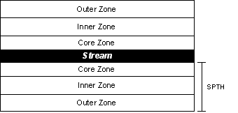
For Western Washington, the FFR require a riparian
buffer on either side of a fish-bearing stream. The required buffer
extends to one site-potential tree height (SPTH) from bankfull
width or the edge of the channel migration zone (CMZ). The SPTH
varies from 90 to 200 feet depending on the site class (V-I).
The riparian buffer is divided into three zones, as shown in Figure
2.1.
| Figure 2.1 | The FFR riparian buffers for Western Washington. |
![]()
- The core zone extends 50 feet from bankfull width or the edge
of the CMZ. No harvesting is allowed in this zone.
- The inner zone extends from the outer edge of the core zone
to 67% of the SPTH for streams less than 10 feet wide or 75% of
the SPTH for streams greater than 10 feet wide. Limited harvest
is allowed in this zone only if the remaining number of trees,
basal area, and proportion of conifer are sufficient to meet the
Desired Future Conditions (DFC) when the stand is 140 years old.
Whether a stand meets these requirements is determined by the
DFC Worksheet program, which is based on the Stand Management
Cooperative (SMC) variant of the ORGANON growth model. Harvesting
that meets these requirements may be done using one of the following
options:
- Option 1: Thinning from below. The smallest trees are removed
down to a minimum of the 57 largest trees per acre or however
many trees are required to meet DFC, whichever is greater.
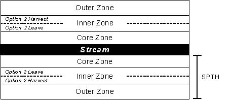
- Option 2: Leave trees closest to the stream. The inner zone
is split into two parts. No harvesting is allowed in the part
closest to the stream (bordering the core zone), but harvest
is allowed in the part furthest from the stream as long as
20 leave trees per acre are left, similar to the outer zone
rules. The part of the inner zone that is not harvested must
be no less than 30 feet wide.
- Option 1: Thinning from below. The smallest trees are removed
down to a minimum of the 57 largest trees per acre or however
many trees are required to meet DFC, whichever is greater.
- The outer zone extends from the outer edge of the inner zone out to the SPTH. Harvest is allowed in this zone as long as 20 conifers per acre over 12 inches in diameter are retained as leave trees. If the inner zone is harvested under Option 2, a basal area credit may be available that decreases the outer zone leave tree requirements to as low as 10 trees per acre.
In addition to the three-zone buffer for fish-bearing streams, 50-foot no-harvest buffers are required around certain portions of perennial, nonfish-bearing streams, including the first 300 to 500 feet above a confluence with a fish-bearing stream, depending on the total length of the nonfish-bearing stream. A 50-foot no-harvest buffer is also required around sensitive sites such as seeps or springs.
The FFR also contain new requirements for forest roads, stream crossings, equipment use, and other aspects of forest management, as well as harvesting restrictions on unstable slopes and wetlands. Additional economic impacts that may result from these management constraints are beyond the scope of this study.
2.2 MITIGATION OF ECONOMIC IMPACTS
Recognizing that the new riparian buffer requirements would have a significant economic impact on small landowners, the FFR include several mitigation options. One option is a forest excise tax credit that is available to any landowner who is impacted by the FFR. The credit refunds 16% of the forest excise tax, reducing the effective tax rate from 5% to 4.2%. Another option is the Forestry Riparian Easement Program (FREP), which is a program exclusively for small landowners. Eligible small landowners who choose to participate in the program are given cash compensation at the time of harvest for a portion of the fair market value of qualifying timber. Qualifying timber is that which must be left unharvested in riparian buffers. Only timber that is left pursuant to the FFR is considered qualifying timber; additional timber that is left voluntarily by the landowner does not qualify for compensation.
If the value of the qualifying timber amounts to 19.1% or less of the total value of the landowner's timber sale, then compensation is given at 50%. If the value of the qualifying timber exceeds a high impact override (HIO) threshold of 19.1% of the total sale value, 50% compensation is given for the first 19.1%, while full compensation is given for the remaining value in excess of 19.1% according to Equation 2.2. To illustrate this, some example calculations are given in Table 2.2.
| Equation 2.2 | Forestry Riparian Easement compensation for qualifying timber. |
|
Where: |
![]()
| Table 2.2. | Example FRE calculations. |
|
TV
|
Vh
|
Vq
|
Net Loss Without the FREP
|
HIO
|
FREP Compensation
|
Net Loss With the FREP
|
|
$50,000
|
$0
|
$50,000
|
100%
|
80.90%
|
$45,225
|
9.55%
|
|
$50,000
|
$35,000
|
$15,000
|
30%
|
10.90%
|
$10,225
|
9.55%
|
|
$50,000
|
$45,000
|
$5,000
|
10%
|
0%
|
$2,500
|
5.00%
|
2.3 WHY THE CASE STUDY APPROACH
Case studies provide insights as to how actual landowners are impacted by the changing regulations. Case studies allow the comparison of different management options, and they reveal the variability of impacts, which may not be apparent from broader studies.
Variability is particularly important when looking at small ownerships. Consider the riparian buffers imposed over the area depicted in Figure 2.3(a). In this case, the impacts of the riparian buffer can be averaged over a large area.
Now consider if the same area was composed of 10 small landowners as in Figure 2.3(b). The average impacts over all parcels remain unchanged from the previous example. However, the impacts are concentrated on individual landowners, causing a large disparity of impacts between landowners.

|
Figure 2.3
|
With large ownerships,
buffer impacts can be averaged over a large area. With small
ownerships, buffer impacts are concentrated on smaller areas.
|
This simplified example illustrates why it is important to consider
the variability and disparity within the range of impacts to individuals.
Case studies provide point estimates of that variability which,
when taken together with the results of broader studies like the
SBEIS (Perez-Garcia, Edelson, and Zobrist 2001), provide a more
complete understanding of the economic impacts of the new rules
on NIPF landowners.
![]()
3.0 METHODS AND ASSUMPTIONS
3.1 CASE STUDY PARTICIPANTS
Small, NIPF landowners with riparian holdings were approached and asked for voluntary participation in this study. Case studies 1 through 6 are from Lewis County in southwest Washington. Cases 7 through 10 are from Grays Harbor County, which is located along the Washington coast (Figure 3.1).
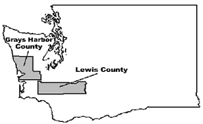
| Figure 3.1 | Case study locations. |
3.2 MODELING
For each case study property, the Landscape Management System (LMS) was used to simulate forest management over time under both the previous rules and the new FFR. LMS is a computer program developed at the University of Washington that integrates a suite of forestry software tools, including growth models and visualization programs. The growth model used within LMS for the case study management simulations was the SMC variant of ORGANON in order to be consistent with the modeling that is used as the basis for the FFR management options.
Modeling in LMS required several sets of data for each case study. The first data needed were GIS data, including property boundaries, a stand map, and the locations and types of all streams. These data were created or obtained for each property and loaded into ArcView GIS. For each stream, the appropriate riparian buffers were digitally overlaid onto the stand map in ArcView according to the specifications of the new rules. For streams classified as fish-bearing, the riparian buffers included the core, inner, and outer zones. The inner zone was further divided to represent management Option 2 under the FFR, in which the part of the zone furthest from the stream is harvested and the part closest to the stream is left untouched. These subdivisions create a set of discrete polygons that are defined by stand and buffer zone (Figure 3.2). These polygons represent unique management units for modeling in LMS.
| Figure 3.2 | Creating unique polygons by stand and buffer zone. |
The next data needed were stand inventory data. Where recent timber
inventory data were not available, sample plots were established
in each stand. Data from these sample plots (or from existing inventory
where available) were used to create a tree list for each stand.
For stands in which riparian areas were not consistent with the
upland areas, a separate inventory was created for each. The inventory
data were then applied to the unique polygons created in ArcView
to build an LMS file or "portfolio" for each landowner
case study.
Site index data were also needed for each case study. Douglas-fir site index was used, as it is needed by the ORGANON growth model and it is also the basis for determining buffer width under the FFR. For some of the case studies in Grays Harbor County, Douglas-fir site index information was not available. In these cases it was computed from western hemlock site index using the following relationship: Douglas-fir site index = (1.11)(western hemlock site index) + 0.48 (Nigh 1995).
![]()
3.3 MANAGEMENT SCENARIOS
Five scenarios were modeled for each case study:
1. Previous Rules
The previous forest practices rules (the permanent rules in effect on January 1, 1999) specified a range of widths and leave tree requirements for riparian buffers on fish-bearing streams. For this analysis we approximated the average impact of these rules by using a 25-foot no-harvest zone to represent riparian buffer requirements for fish-bearing streams before the FFR. No buffers were required for nonfish-bearing streams under the previous rules.
The other four scenarios represent four possible riparian management options under the FFR.
2. FFR with no riparian harvest
For this scenario it was assumed that no harvesting was done in any of the FFR buffer zones. While the rules allow some harvesting in the outer and inner zones, some small landowners choose to treat the entire buffer as a no-cut area.
3. FFR with riparian harvest in the outer zone only
This scenario assumed that harvesting was done in the outer zone, which is allowed as long as there are a minimum number of leave trees greater than 12" DBH. No trees were cut in the inner zone under this scenario.
4. FFR with inner/outer zone riparian harvest Option 1
In this scenario, harvest was done in the outer zone and also in the inner zone if basal area was adequate to meet the Desired Future Conditions (DFC). Inner zone harvest was done according to Option 1, in which the smallest trees are harvested and the larger trees are left (thin from below). Determining which, if any, trees could be cut under Option 1 was done by feeding the predicted inventory at the time of harvest into the DFC Worksheet program (version 1.1.12). The DFC Worksheet is a program provided by the DNR that specifies how many trees from each diameter class may be harvested under Option 1 or what portion of the inner zone can be harvested under Option 2. The DFC Worksheet also computes any basal area credits in the outer zone under Option 2. Because DFC Worksheet specifies removal of the maximum number of trees while still achieving DFC at age 140, this study assumes that no further harvesting will be allowed in the inner zone.
5. FFR with inner/outer zone riparian harvest Option 2
As with the previous scenario, harvesting in this scenario was done in the outer zone and also the inner zone if basal area was adequate to meet DFC according to the DFC Worksheet. This time harvesting in the inner zone was done according to Option 2, in which the inner zone is split into two parts. No harvest was done in the part closest to the stream (bordering the core zone). A clear-cut harvest was done in the part furthest from the stream, leaving the minimum leave trees required by the rules. In addition, a basal area credit sometimes allowed the reduction of the required leave trees in the outer zone under this option. The width of the harvested portion of the inner zone and the amount of basal area credit were determined by the DFC Worksheet. Note that Option 2 is not allowed with large streams on site class III or lower. If there was a mix of large and small streams on site class III or lower, this scenario used Option 2 where allowed along the small streams, but Option 1 was used along the large streams.
The basic management strategy underlying each of these five scenarios was based on information gathered about the typical management practices and goals of small landowners in the study area. This included information from the participating landowners. Two rotations were simulated for each case study: the current rotation and an additional full rotation.
The management simulations for the Lewis County case studies assumed a 50-year rotation of Douglas-fir with an early commercial thin and a clear-cut harvest. Most of the existing timber inventory was consistent with this management strategy. When the final harvest of the existing timber was complete, a subsequent rotation was starting by planting of 435 Douglas-fir per acre with an assumed survival rate of 90% to 95%. The simulation of the subsequent rotation included an early commercial thin from below to 180 stems per acre at age 20 and a final harvest at age 50.
The management simulations for the Grays Harbor County case studies assumed a 50-year rotation of Douglas-fir with a precommercial thin, one commercial thin, and a clear-cut harvest. Existing timber was consistent with this management strategy for the most part, though some of the existing stands were actually western hemlock stands that the landowner plans to convert to Douglas-fir in the subsequent rotation. When the final harvest of the existing timber was done, a subsequent rotation was starting by planting of 435 Douglas-fir per acre with an assumed survival rate of 90% to 95%. Additional natural ingrowth of approximately 600 western hemlock per acre was also assumed. The simulation of the subsequent rotation included a precommercial thin at age 15, leaving 200 Douglas-fir per acre and 70 western hemlock per acre. It also included a commercial thin from below at age 35 to remove half of the stems. Final harvest was done at age 50.
For the harvest simulations under the previous rules and for upland harvests under the FFR scenarios, two trees per acre were left as green recruitment trees in accordance with the forest practices rules.
![]()
3.4 ECONOMIC ASSUMPTIONS
Calculating the economic figures required assumptions about costs and prices. The average log prices for the year 2000 as reported in Log Lines (2001) were used. Region 1 (Puget Sound) prices were used for the Lewis County case studies and Region 2 (Washington coast) prices were used for the Grays Harbor case studies. Logging and haul costs were based on information from the Washington Landscape Management Project (Lippke, Sessions, and Carey 1996). The cost per thousand board feet (Mbf) was determined by the average diameter of the harvested trees. Higher costs were used for cable logging compared to ground logging and for commercial thinning compared to a clear-cut harvest. Cable logging prices were applied to stands with greater than 30% average slope; otherwise ground prices were used.
Other costs were based on input from local foresters and participating landowners. These costs are summarized in Table 3.4.
| Table 3.4 | Forest management cost assumptions. |
|
|
Lewis County
|
Grays Harbor County
|
| Planting | $239/acre ($0.55/seedling) | $239/acre ($0.55/seedling) |
| Precommercial thin | N/A | $100/acre |
| Early commercial thin | break-even (no net cost or revenue) | N/A |
| Annual overhead | $40/acre/year | $40/acre/year |
Additional costs were added to the FFR management scenarios in which
harvesting was done in the riparian zone. For nonfish-bearing streams
requiring a 50-foot buffer and for fish-bearing streams in the outer
zone harvest only scenario, an additional layout cost of $0.50 per
linear foot of stream was applied to reflect the additional expense
of delineating the buffer zones. For fish-bearing streams in the
Option 1 and Option 2 scenarios, an extra layout cost of $2.50 per
linear foot of stream was applied. This reflects the additional
expense of delineating the buffer zones plus the other expenses
associated with these options, such as a 100% cruise in the core
and inner zones and running the DFC Worksheet program.
The only tax included in the analysis was the Washington forest excise tax, which was 5% under previous rules and 4.2% under the FFR. For this analysis it was assumed that there would be no real change in costs or log prices over time. All calculations assumed constant dollars and a real target rate of return of 5%.
3.5 ECONOMIC ANALYSIS
Economic analysis for each case study was done by comparing land expectation value and total forest value between the previous rules and the four FFR management scenarios. For the FFR scenarios a comparison was also done of forest value with and without the FREP. Calculations of land value and forest value were based on Faustmann's approach (Faustmann [1849] 1995).
3.5.1 Land Value
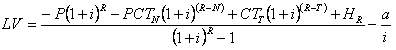
This figure, also known as bare land value, land expectation value (LEV), or soil expectation value (SEV), estimates the economic value of the land alone based on its ability to generate income through the production of timber. It is calculated by taking the net present value of all the costs and revenues associated with growing timber in perpetuity when starting with bare land. In other words, land value is the sum of all the planting costs, thinning costs, net harvest revenues, and annual administrative costs from an infinite number of timber rotations discounted to the present from their respective years using a target rate of return. This value represents the amount someone would be willing to pay for bare land for the purpose of growing timber given a target rate of return and management assumptions.
The land value figures for these case studies may be positive or negative. A positive land value means that growing timber on the property under the given assumptions will earn higher than the target rate of return. Similarly, a negative land value means that growing timber on the property under our assumptions will earn lower than the target rate of return. Thus, land values are higher with lower interest rates and vice versa. A land value of zero would mean that growing timber on the land would earn exactly the target rate of return.
Land value is a very important figure because it represents the overall economic competitiveness of using the land to grow timber. As land values (and hence rates of return) fall, growing timber becomes less competitive relative to other potential land uses. Thus, a decrease in land value may lead to an increase in land-use conversion. Equation 3.5.1 was used to calculate land value.
![]()
| Equation 3.5.1 | Forestry Riparian Easement compensation for qualifying timber. |
|
Where: |
3.5.2 Forest Value
Forest value is land value plus the added economic value of any standing timber (the total economic value of the forest). It is important to note that when calculating forest value, the economic value of currently standing timber is not the same as the net present market value. The economic value of the timber is the net present market value minus "land rent," which is the economic opportunity cost of using the land to hold the existing timber rather than starting a new rotation and earning land value. By combining the economic value of land and timber, forest value represents the total economic value of a forest asset.
If the current crop of timber is near the end of its rotation, it will have a high economic value (because revenues will be realized in the near future) and thus forest value will be much higher than land value. If the current crop of timber is very young, forest value will not be much higher than land value because it is only a few years past a bare land condition. In rare cases where the net present market value of the timber is lower than the opportunity cost of holding the land, forest value may actually be less than land value. This implies that it would be better economically to liquidate the current crop and start a new crop immediately rather than continuing to hold the current crop. Equation 3.5.2 was used to calculate forest value.
| Equation 3.5.2 | Forest value. |
|
Where: |
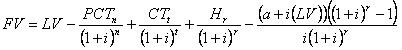
3.5.3 Forest value with the FREP
This is forest value with cash compensation from the FREP factored in. This includes compensation for qualifying timber and reimbursement for additional layout costs associated with harvesting in the riparian zone. Equation 3.5.3 was used to calculate forest value with the FREP.
| Equation 3.5.3 | Forest value with the FREP. |
|
Where: |
![]()
4.0 CASE STUDY RESULTS
The collective results of the case studies are summarized below. More detailed results for individual case studies can be found in Appendix A.
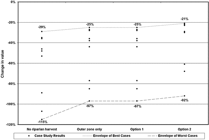
4.1 IMPACTS ON FOREST VALUE
The impacts of the FFR on the forest value for each case study are summarized in Table 4.1 as a percent change relative to the previous rules. In each case, there is a significant loss in forest value under any of the FFR management options. The losses are highest if no harvesting is done in the riparian zone, ranging from 23% (Case 4) loss to 54% (Case 1). Losses are lower if harvesting is done in the outer zone, ranging from 18% (Case 8) to 37% (Cases 1 and 3). Losses are lower still for some cases if harvesting is done in both the outer zone and the inner zone under option 1 or option 2. This is not true for all cases, though, as Case 8 remains unchanged and in Cases 7 and 9 the loss in forest value would actually be higher under option 1 or option 2 compared to harvesting only in the outer zone. Some of the FFR management options are not applicable for some case studies and are displayed as "NA" in Table 4.1. The range and distribution of forest value impacts are plotted in Figure 4.1.
| Table 4.1 | Percent change in case study forest value under the FFR relative to the previous rules. |
| Scenario |
Case 1
|
Case 2
|
Case 3
|
Case 4
|
Case 5
|
Case 6
|
Case 7
|
Case 8
|
Case 9
|
Case 10
|
| No riparian harvest |
-54%
|
-31%
|
-46%
|
-23%
|
-37%
|
-46%
|
-36%
|
-26%
|
-27%
|
-44%
|
| Outer zone harvest only |
-37%
|
-22%
|
-37%
|
-21%
|
-26%
|
-34%
|
-31%
|
-18%
|
-23%
|
-36%
|
| Option 1 |
-30%
|
NA
|
-36%
|
-18%
|
-25%
|
-31%
|
-33%
|
-18%
|
-27%
|
-35%
|
| Option 2 |
-27%
|
NA
|
-35%
|
-17%
|
-20%
|
-30%
|
-32%
|
-18%
|
-27%
|
NA
|
| Figure 4.1 | Range and distribution of the impacts of the FFR on case study forest values. |
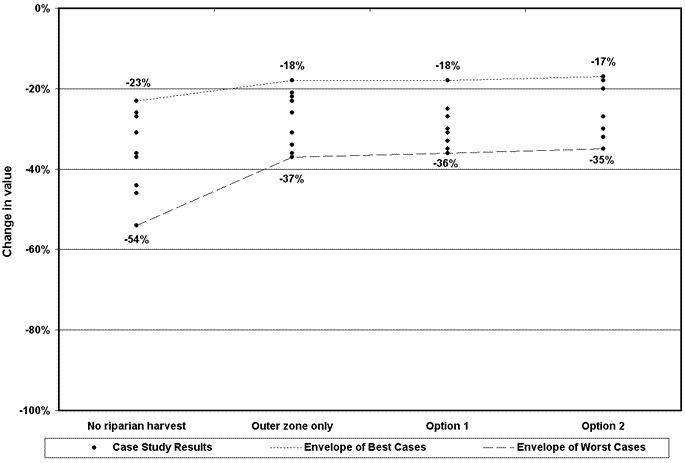
4.2 IMPACTS ON LAND VALUE
The impacts of the FFR on the land value for each case study are
summarized in Table 4.2 as a percent change relative to the
previous rules. The impacts on land value are greater than the impacts
on forest value, ranging from a 29% loss (Case 9) to a 115% loss
(Case 1) if no riparian harvest is done. A loss in excess of 100%
indicates that the target rate of return is not achieved for that
scenario. The losses are lower if harvesting is done in the outer
zone, ranging from 25% (Case 9) to 97% (Case 3). Losses in land
value would not be reduced further by harvesting in the inner zone
under option 1, but they would be reduced further if option 2 was
chosen. Under option 2 the losses range from 21% (Case 8) to 92%
(Case 3). The range and distribution of land value impacts are plotted
in Figure 4.2.
| Table 4.2 | Percent change in case study land value under the FFR relative to the previous rules. |
| Scenario |
Case 1
|
Case 2
|
Case 3
|
Case 4
|
Case 5
|
Case 6
|
Case 7
|
Case 8
|
Case 9
|
Case 10
|
| No riparian harvest |
-115%
|
-48%
|
-107%
|
-36%
|
-46%
|
-89%
|
-48%
|
-35%
|
-29%
|
-53%
|
| Outer zone harvest only |
-85%
|
-38%
|
-97%
|
-28%
|
-36%
|
-77%
|
-38%
|
-27%
|
-25%
|
-44%
|
| Option 1 |
-85%
|
NA
|
-97%
|
-28%
|
-36%
|
-77%
|
-38%
|
-27%
|
-25%
|
-44%
|
| Option 2 |
-61%
|
NA
|
-92%
|
-22%
|
-30%
|
-68%
|
-29%
|
-21%
|
-23%
|
NA
|
![]()
| Figure 4.2 | Range and distribution of the impacts of the FFR on case study land values. |
4.3 IMPACTS OF MITIGATION
The two mitigation options for small landowners are the forest excise tax credit and the FREP. The results above already assume that the landowner has received the forest excise tax credit under the FFR management scenarios. If cash payments from the FREP are also factored in, the net change in forest value for each case study with full mitigation is summarized in Table 4.3. The FREP significantly reduces both the magnitude and disparity of forest value losses across all FFR scenarios. With no riparian harvest, the impacts range from a 12% loss (Case 1) to a 29% loss (Case 9). This is roughly half of what the losses would be without the FREP. If riparian harvest is done under Option 2, the impacts range from a 1% loss (Case 1) to a 13% loss (Case 3). The loss for Case 3 drops to 12% if Option 1 is done instead of Option 2. Thus, if the economically optimal harvest strategy is used for each case, the impacts with the FREP range from a 1% loss to a 12% loss. The range and distribution of forest value impacts with and without the FREP is plotted in Figure 4.3.
The FREP only compensates for existing timber; it does not compensate for the lost value of land acreage that can no longer be used for commercial timber production. This leaves the impacts on land value unchanged.
| Table 4.3 | Percent change in case study forest value under the FFR relative to the previous rules with cash compensation from the FREP included. |
| Scenario |
Case 1
|
Case 2
|
Case 3
|
Case 4
|
Case 5
|
Case 6
|
Case 7
|
Case 8
|
Case 9
|
Case 10
|
| No riparian harvest |
-29%
|
-15%
|
-25%
|
-15%
|
-20%
|
-20%
|
-17%
|
-21%
|
-12%
|
-17%
|
| Outer zone only |
-11%
|
-5%
|
-16%
|
-12%
|
-8%
|
-7%
|
-10%
|
-11%
|
-6%
|
-8%
|
| Option 1 |
-2%
|
NA
|
-12%
|
-9%
|
-1%
|
-2%
|
-9%
|
-10%
|
-5%
|
-3%
|
| Option 2 |
-1%
|
NA
|
-13%
|
-8%
|
-1%
|
-2%
|
-5%
|
-9%
|
-4%
|
NA
|
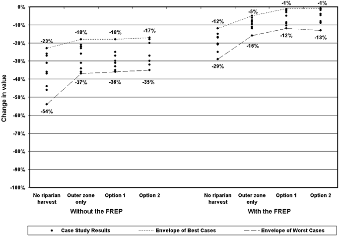
| Figure 4.3 | Range and distribution of the impacts of the FFR on case study forest values. with and without the FREP. |
![]()
5.0 DISCUSSION
5.1 ECONOMIC IMPACTS AND MANAGEMENT OPTIONS
The results of these case studies indicate that some small landowners will potentially incur significant economic losses as a result of the FFR and that there is indeed a large variability and disparity of impacts across different landowners. Both the severity and the disparity of economic losses depend on the riparian management scenario, which implies that whether or not to harvest in the riparian zone is a very important question facing small landowners.
For each case study, economic losses were higher under the no riparian harvest scenario compared to the scenarios in which partial harvesting was done in the riparian zone. Harvesting in the outer zone appreciably reduced economic losses compared to the no riparian harvest scenario. Given that harvesting in the outer zone does not require significant additional layout costs, this may be a desirable option for many landowners. According to the Small Forest Landowner Office this has indeed been the preferred option for most small landowners who have harvested under the new rules.
Harvesting in both the inner and outer zones using Option 1 or Option 2 further reduced economic losses in some of the case studies, but the incremental benefit of harvesting in the inner zone was relatively small. Part of the reason for this is that landowners should expect to incur significant additional layout and consulting costs by entering the inner zone. In some cases (Case 7 and Case 9), the costs of harvesting in the inner zone outweighed the benefits altogether. However, the FREP will reimburse participating landowners for these extra layout costs, as they are required for the preparation of the easement. Thus, whether or not a landowner is planning to apply for the FREP may determine whether it is economically advantageous to harvest in the inner zone.
Land values seem to be particularly sensitive to the new rules, with some case studies losing most or all of their land value. Land value for forest management is completely lost in no-cut areas such as the core zone and parts of the inner zone, as these acres can no longer be used for commercial management. If a significant portion of a given property is taken out of production because of buffer restrictions, it may make the entire property unprofitable, as there is now a much smaller production base to cover fixed overhead costs. Fragmentation may also make management unfeasible even in unrestricted areas.
Significant decreases in land value imply that it will not be economically viable for some landowners to continue to use their property for forest management beyond the current rotation given the new rules. Depending on what other values these landowners associate with their property besides economic returns, this could motivate land-use conversion, particularly to real estate uses (Lippke and Bare 1997). NIPF lands in Western Washington tend to interface with urbanizing areas, and real estate conversion of NIPF lands is a growing concern (Stinson 2000). NIPF lands in Washington have already been converted at a rate of almost 100 acres per day in recent years (WADNR 1998). The diminished economic returns for continued forest management under the FFR can be expected to exacerbate that trend.
5.2 EFFECTIVENESS OF MITIGATION
The economic impacts of the FFR for these case studies were significant despite factoring in the forest excise tax credit that is available to landowners under the new rules. This suggests that the tax credit does not effectively mitigate the economic losses resulting from the new riparian buffer requirements. This is consistent with a study by the Washington Department of Revenue which found that the value of required riparian leave trees far exceeded the value of the forest excise tax credit (WADOR 2002).
In contrast, the case study results demonstrate that
the FREP can be very effective at mitigating losses, especially
when harvesting is done in the riparian zone. When cash payments
from the FREP are considered, the forest value impacts of the FFR
range from a 1% loss to a 12% loss under the least impact scenario.
Thus, it appears that the FREP significantly reduces both the magnitude
and disparity of economic losses for small landowners.
The extent to which compensation from the FREP mitigates economic
losses is surprising. There are several reasons why it is so effective:
- Compensation under the FREP is not given on a property-wide
basis, but on an individual stand (harvest unit) basis. In many
cases, riparian losses are concentrated in only a few stands on
the property. Even though the loss for the property as a whole
does not exceed the 19.1% high impact threshold, losses for those
particular stands do. Thus, those stands are compensated sometimes
well above 50%, which considerably reduces the loss to the property
as a whole.
- The FREP compensates not only for the new riparian leave tree
requirements under the FFR but also for riparian leave trees that
were required under the previous rules. This significantly reduces
the incremental impact of the FFR relative to the previous rules.
- The FREP reimburses landowners for the extra layout costs associated
with harvesting in the inner zone. This makes it economically
feasible to recover additional value from the riparian zone that
would otherwise have been cost prohibitive for some landowners.
- The value that landowners receive for their qualifying timber is not subject to the forest excise tax like it would be if the timber were actually harvested.
Despite its apparent effectiveness, the FREP does have several significant shortcomings. If participation is high, the cost will far exceed current funding plans. Estimated easements paid for these ten case studies alone exceed $2.4 million over the next 45 years at year 2000 log values. The present value of this cost at a 5% discount rate is approximately $777,000, which is equivalent to a cost of about $44,000 per year for 45 years.
The total riparian acreage for the ten properties in this study is 400. This yields a nominal cost per riparian acre of approximately $6,000 over the next 45 years, with a present value cost per riparian acre or $1,942. Based on the SBEIS analysis (Perez-Garcia et al. 2000), there are approximately 1,372,175 acres of NIPF parcels greater than 20 acres in Western Washington that are eligible for the FREP. According to a 1997 GIS analysis sponsored by the Washington Forest Protection Association, 17.41% of these acres are riparian acres (From a report prepared for the Washington Hardwoods Commission by Marshall and Associates, Inc.). Using this figure, there are approximately 238,896 riparian acres on NIPF land in Western Washington that are subject to the FFR. Assuming the cost per riparian acre is consistent throughout Western Washington, the total Westside cost for full participation in the FREP would be over $1.4 billion over 45 years at year 2000 prices. The present value of this cost would be over $463 million, which is equivalent to a cost of about $26 million per year for the Westside alone. Statewide funding for the FREP was $5 million for the first biennium, which was reduced to $2 million for the following biennium. Future funding for this program is uncertain, but it is unlikely that it will ever be funded at adequate levels for large-scale participation. Thus, the majority of small landowners will not enjoy the benefits of this program.
Another shortcoming of the FREP is that the easement only compensates for currently standing timber. It does not compensate for the loss in land value of riparian acreage that can no longer be used for sustainable forest management. By not mitigating the substantial reductions in land values under the new rules, the FREP does not address the potential unintended consequence of increased forestland conversion.
![]()
5.3 BROADER IMPLICATIONS
The results of these case studies show the economic impacts of Washington's new forest practices regulations to be not only more severe than the previous regulations, but also more severe than regulations in other regions. Lickwar, et al. (1992), for instance, found that implementing best management practices in the Southeast to protect water quality only reduced gross harvest revenue by 2.9%. Another study in Wisconsin found that new requirements did not significantly decrease and may even increase (depending on the baseline used) net present values for landowners (Stier and Martin 1997). Similarly, Kittredge, et al. (1999) found little impact from forest practices regulations when they compared regulations in two states in the Northeast.
Of these three studies from other regions, only Lickwar, et al. (1992) involved riparian buffers, and the restrictions were much less stringent than with the FFR. Thus, the restrictive buffer requirements of the FFR may set Washington apart from other states and regions in terms of the economic impacts of forest practices regulations. This is consistent with a study done on national forests in the Midwest, which found leaving buffer strips to be the most expensive practice to protect water quality, resulting in a net revenue reduction of over 26% (Ellefson and Miles 1985).
While these rules and their impacts are unique to the state of Washington, other states are facing similar issues. Forest practices regulations have become increasingly strict in the West over the past few decades (Cubbage 1995). The East has also seen trends towards increasing state and local regulation of private forestry, and those trends are predicted to continue (Cubbage and Siegel 1988). If regulations do indeed continue to increase, especially if they involve riparian buffers, landowners in other states can expect to face larger economic impacts. Washington's rules represent an important starting point for understanding the implication of those impacts and the ability of public cost sharing programs like the FREP to mitigate those impacts.
5.4 FUTURE RESEARCH
In addition to the FREP, the FFR include an additional provision to address economic impacts. This provision gives landowners the flexibility to pursue alternate management plans that "meet riparian functions while requiring less costly regulatory prescriptions" (RCW 76.113.110). The FFR further provide for the creation of templates to facilitate the implementation of alternate plans. Given the funding and other shortfalls of the FREP, alternate plan templates will be an important mechanism for mitigating economic impacts. Future research will focus on the development of templates that effectively meet riparian functions while maintaining the economic viability of landowners.
![]()
REFERENCES
Cubbage, F.W. 1995. Regulation of private forest practices: What rights, which policies? Journal of Forestry 93(6):14-20.
Cubbage, F.W. and W.C. Siegel. 1988. State and local regulation of private forestry in the East. Northern Journal of Applied Forestry 5(2):103-108.
Ellefson, P.V. and P.D. Miles. 1985. Protecting water quality in the Midwest: impact on timber harvesting costs. Northern Journal of Applied Forestry 2(2):57-61.
Faustmann, M. 1995. Calculation of the value which forest land and immature stands possess for forestry. Journal of Forest Economics 1(1):7-44. Reprint of translation in Institute Paper 42, Commonwealth Forestry Institute, University of Oxford, 1968. First published in Allgemeine Forst- und Jagd-Zeitung 15, 1849.
Forests and Fish Report. 1999. Available online at http://www.dnr.wa.gov/forestpractices/rules/forestsandfish.pdf; last accessed June 2003.
Kittredge, D.B., M.G. Rickenbach, and S.H. Broderick. 1999. Regulation and stumpage prices: A tale of two states. Journal of Forestry 97(10):12-16.
Lickwar, P., C. Hickman, and F.W. Cubbage. 1992. Costs of protecting water quality during harvesting on private forestlands in the Southeast. Southern Journal of Applied Forestry 16(1):13-20.
Lippke, B. and B.B. Bare. 1997. Viability of non-industrial private forest sector in Washington State. Unpublished.
Lippke, B., S. Marshall, M. Ludwig, J. Moffett, D. Fitzpatrick, and B.B. Bare. 2000. Lewis County economic assessment. CINTRAFOR Special Paper 35. Seattle, WA: Center For International Trade In Forest Products, College of Forest Resources, University of Washington.
Lippke, B.R., J. Sessions, and A.B. Carey. 1996. Economic analysis of forest landscape management alternatives. CINTRAFOR Special Paper 21. Seattle, WA: Center For International Trade In Forest Products, College of Forest Resources, University of Washington.
Log Lines. 2001. 2001 Statistical Yearbook. Mount Vernon, WA: Arbor-Pacific Forestry Services, Inc. and Resource Information Systems, Inc.
Nigh, G. 1995. The geometric mean regression line: A method for developing site index conversion equations for species in mixed stands. Forest Science 41(1):84-98.
Oneil, E. 2003. Impacts of the forest and fish rules on small forest landowners in Eastern Washington: some key consequences from riparian zone case study analysis. Master's thesis, College of Forest Resources, University of Washington, Seattle, WA.
Perez-Garcia, J.M., J. Edelson, and K. Zobrist. 2001. New proposed forest practices rules small business economic impact statement. Olympia, WA: Washington State Department of Natural Resources.
Stier, J.C. and A.J. Martin. 1997. Economic impacts of timber harvest regulations in the Lower Wisconsin State Riverway. Northern Journal of Applied Forestry 14(3):126-134.
Stinson, S.D. 2000. Family forest conservation project: Lewis County Washington pilot project for non-industrial private forests. In Proceedings of Summit 2000: Washington Private Forests Forum, March 2000, edited by J.K. Agee. Seattle, WA: Institute of Forest Resources, College of Forest Resources, University of Washington.
Washington Department of Natural Resources (WADNR). 1998. Our changing nature: Natural resource trends in Washington State. Olympia, WA.
Washington Department of Revenue (WADOR). 2002. Comparing the value of "Forests and Fish" leave-trees with the forest excise tax credit. Report to the Legislature. Olympia, WA.
Zobrist, K. and B.R. Lippke. 2003. Case studies examining the economic
impacts of new forest practices regulations on NIPF landowners.
In Forest policy for private forestry: Global and regional challenges,
edited by L. Teeter, B. Cashore, and D. Zhang. Wallingford, UK:
CABI Publishing.
![]()
RELATED WEB SITE
(URLs are current as of July 2003)
- DFC Worksheet Program:
http://www.dnr.wa.gov/forestpractices/dfc/
- Forest Practices Act (Chapter 76.09 RCW):
http://www.leg.wa.gov/RCW/index.cfm?fuseaction=chapterdigest&chapter=76.09
- Forest Practices Board:
http://www.dnr.wa.gov/forestpractices/board/
- Forest Practices Rules (Title 222 WAC):
http://www.leg.wa.gov/wac/index.cfm?fuseaction=title&title=222
- Landscape Management System (LMS):
http://lms.cfr.washington.edu/lms.shtml
- ORGANON:
http://www.cof.orst.edu/cof/fr/research/organon/
- Rural Technology Initiative:
http://www.ruraltech.org
- Small Forest Landowner Office:
http://www.dnr.wa.gov/sflo/
- University of Washington College of Forest Resources:
http://www.cfr.washington.edu/
- Washington Department of Natural Resources:
http://www.dnr.wa.gov/
- Washington State University Natural Resources Extension:
http://ext.nrs.wsu.edu/