|
 |
 |
 |


Equity in Urban Forest Management:
An assessment of street tree condition, maintenance, and neighborhood
income levels in
Seattle, Washington
|
by: Ara Kaufer Erickson
Master of Science
2004
|
|||||||||||||||||||||||||||||||||||||||||||||||||||||||||||||||||||||||||||||||||||||||||||||||||||||||||||||||||||||||||||||||||||||||||||||||||||||||||||||||||||||||||||||||||||||||||||||||||||||||||||||||||||||||||||||||||||||||||||||||||||||||||||||||||||||||||||||||||||||||||||||||||||||||||||||||||||||||||||||||||||||||||||||||||||||||||||||||||||||||||||||||||||||||||||||||||||||||||||||||||||||||||||||||||||||||||||||||||||||||||||||||||||||||||||||||||||||||||||||||||||||||||||||||||||||||||||||||||||||||||||||||||||||||||||||||||||||||||||||||||||||||||||||||||||||||||||||||||||||||||||||||||||||||||||||||||||||||||||||||||||||||||||||||||||||||||||||||||||||||||||||||||||||||||||||||||||||||||||||||||||||||||||||||||||||||||||||||||||||||||||||||||||||||||||||||||||||||||||||||||||||||||||||||||||||||||||||||||||||||||||||||||||||||||||||||||||||||||||||||||||||||||||||||||||||||||||||||||||||||||||||||||||||||||||||||||||||||||||||||||||||||||||||||||||||||||||||||||||||||
| Figure 1. | Relationships between income and street tree condition and maintenance |
| Figure 2. | Map of study site |
| Figure 3. | Recruitment flyer |
| Figure 4. | Map of study sites |
| Figure 5. | Tree condition assessment criteria |
| Figure 6. | Tree condition distribution |
| Figure 7. | Average tree condition in sampled tracts compared by income levels |
| Figure 8. | Distribution of tree condition categories in sampled tracts |
| Figure 9. | Average tree condition for high and low-income areas |
| Figure 10. | Distribution of tree condition categories for high and low-income areas |
| Figure 11. | Map of tree condition |
| Figure 12. | Tree maintenance (per total trees): sampled tracts |
| Figure 13. | Tree maintenance (per total city trees): sampled tracts |
| Figure 14. | Tree maintenance (per total trees): high and low-income |
| Figure 15. | Tree maintenance (per total city trees): high and low-income |
| Figure 16. | Map of tree maintenance |
| Figure 17. | Factors affecting average tree condition between high and low-income areas |
| Figure 18. | Citywide street tree maintenance |
| Figure 19. | Citywide street tree maintenance by year |
| Figure 20. | Map of citywide street tree maintenance |
List of Tables
| Table 1. | Data sets and sources |
| Table 2. | Demographic information for selected areas |
| Table 3. | Composition of Seattle's 15 most common street tree species |
| Table 4. | Tree condition categories |
| Table 5. | Example of work records entry |
| Table 6. | Work record information for six areas |
| Table 7. | Number of visits and number of trees worked on in six areas |
| Table 8. | Work levels per total city trees for six areas |
| Table 9. | Tree and work information for low and high-income areas |
| Table 10. | Visits and trees worked on per total trees |
| Table 11. | Visits and trees worked on per City trees |
| Table 12. | Additional factors |
| Table 13. | Census tract information |
| Table 14. | Street tree maintenance 1998-2002: counts |
| Table 15. | Street tree maintenance 1998-2002: frequencies |
![]()
Acknowledgements
I wish to express my deepest gratitude to all of the people and
groups who made this project possible.
To Witney, Lauren, Kimiko, Catherine, and Mackenzie, who made the entire project so meaningful. Your enthusiasm and positive responses to this endeavor, made me so grateful that we were able to spend the summer together and proud of what you added to this project.
To my committee chair, Gordon Bradley, for your immense support, compassion, and guidance throughout the entirety of my graduate school adventure. Your encouragement made me continue when I was ready to surrender all hope. To Rowan Rowntree, for guiding me towards the field of urban forestry and providing me with an endless flow of compassionate- and wisdom-filled words. You are the mentor I have always dreamed of having. To Kathy Wolf, for teaching me the real workings of urban forestry and for sharing your amazing insight and expertise. I admire your dedication to this field and am grateful for your excellent edits, counsel, and suggestions throughout this project.
To the Community Forestry Research Fellowship program, for providing financial and intellectual support. Your program is one of the most worthwhile programs I have encountered–and I feel extremely fortunate to be part of it.
To my parents, Ben and Gilda Wheeler, for enduring my long study weekends and providing excellent edits, advice, and support (as well as a great laundry facility). You truly carried me through this process.
To my friends and classmates, who never failed to lift my spirits and provide an amazing support system. I am in awe of your motivation, passion, and outstanding ability in all that you undertake.
Thank you.
Introduction
It is widely accepted that benefits of urban forests include energy
savings, reduced stormwater runoff, clean air, reduced levels of
violence, increased levels of community involvement and interaction,
higher property values, aesthetic values and more. These benefits
greatly enhance a neighborhood’s social, ecological, and
economic well-being. Because of the myriad of benefits provided
by urban forests, it can be argued that the urban forest should
be considered part of the basic infrastructure of urban cities
and towns where people reside.
It is vital that the benefits of urban forests be equally distributed
across communities, not just to select groups of individuals who
have the financial, intellectual, and political resources to acquire
increased levels of urban forest care and attention. Unfortunately,
for an assortment of reasons, many cities appear to have varying
degrees of street tree condition in different neighborhoods. Tree
maintenance from homeowners, pollution levels, soil type, age and
species of trees, and damage from automobiles are just a few explanations.
One additional reason may be the socioeconomic level of a neighborhood;
there is an unspoken assumption that the urban trees may be indirectly
(or directly) affected by a neighborhood’s economic status.
This study explored the relationships between neighborhood income
levels, the condition of the neighborhood street trees, and the
level of tree maintenance provided by the City of Seattle, Washington.
A sample of tree condition, census data, and street tree maintenance
records were used to investigate the above relationships. In addition,
this study incorporated participatory research methods into the
majority of the steps by including high-school students in the
data preparation and data collection stages.
Chapter One begins with a brief background on urban forest benefits
and the important roles trees play in the quality and health of
life in a city—and the importance of equal access to these
benefits. Additional information is presented regarding the documented
need for good urban forest management and problems associated with
the delivery of tree maintenance across an entire city. The background
concludes with a review of studies on socioeconomic factors with
regard to urban trees. The final sections of the first chapter
are dedicated to research objectives, presentation of the hypotheses,
and a description of the study site.
Chapter Two describes the methods used in the study: data sources,
data manipulation, and the subsequent analysis. Chapter Three presents
results from the tree condition assessment and tree maintenance
records in relation to median household income. Discussion of the
results and the larger context of the findings are presented in
Chapter Four. The thesis concludes with a brief look at the limitations
of this study, implications of the findings, and possibilities
for future research. The community participation aspects of the
project are presented throughout the paper.
![]()
Chapter 1: Background and Literature
URBAN FORESTS AS PART OF THE URBAN INFRASTRUCTURE
Urban forests are known to provide many benefits – ecologically
and socially – to cities and their residents. It is gradually
being accepted that urban forests are an integral part of the basic
infrastructure of urban cities and urbanizing areas. Just as sewers
direct wastewater, streetlights provide safety, and road systems
provide safe, reliable transportation, people have begun to recognize
the wealth of benefits provided by urban forests. Although these
benefits often commingle, they can be described in three categories:
ecological, social, and economic.
Ecological Benefits of Urban Forests
Reduced levels of storm water runoff
In cities with large amounts of rain, or infrequent yet heavy rainstorms,
storm water management is costly and extremely important. With
an ever-increasing amount of impervious surfaces in our expanding
cities, storm water hits the ground and rapidly finds its way into
storm drains and holding tanks, rather than seeping into the ground,
resulting in large amounts of pollutants entering our waterways.
Urban trees afford an opportunity for cities to significantly reduce
the costs of storm water management and act as nature’s water
storage system. In Dayton, Ohio, Sanders calculated that the city
tree canopy lowered potential water runoff by approximately 7%
for a 6-h, 1-year storm event (Sanders 1986).
Removal of air pollutants
Air quality in cities continues to be extremely important as industry,
vehicles, and other sources of pollution continue to emit harmful
pollutants into the atmosphere. It is widely recognized that trees
intercept some airborne pollutants from the air and remove some
gaseous pollutants via stomata uptake. Depending on their size
and species, urban trees can remove large amounts of pollutants
from the air. From a computer simulation, it was estimated that
trees in New York, Philadelphia, Baltimore, and Boston removed,
respectively, 1821 metric tons, 1031 metric tons, 499 metric tons,
and 278 metric tons from the air in 1994 (Nowak et al. 1998). In
an earlier study, Chicago’s trees removed an estimated 5575
metric tons of air pollutants (Nowak 1994).
![]()
Carbon storage
While the debate surrounding global climate change still wages,
there is an accepted need to mitigate the large amounts of carbon
being emitted into the atmosphere. It was estimated that the national
urban tree cover plays a critical role in reducing the effects
of carbon emissions as it stores between 350 and 750 million metric
tons of carbon and approximately 27 tons/acre – a substantial
carbon sink (Rowntree and Nowak 1991, Nowak 1993, McPherson et
al. 1997).
Social Benefits of Urban Forests
Community ties
In a study conducted at a large public housing site in Chicago,
researchers found that increased levels of vegetation and presences
of trees resulted in
stronger neighborhood social ties. People living near the green spaces had
increased levels of interactions with neighbors, stronger senses of belonging,
and were more apt to spend time outdoors than people living adjacent to barren
spaces (Kuo et al. 1998). Urban forests also provide an opportunity for community
interactions through tree-planting programs. Dwyer and others wrote, “Active
involvement in tree-planting programs has been shown to enhance a community’s
sense of social identity, self-esteem, and territoriality…(Dwyer et al.
1992).”
Reduced levels of violence
Kuo and Sullivan also found that individuals living near the greener common
spaces felt safer in their homes and buildings than the residents living near
relatively barren spaces (Kuo et al. 1998). In another study, the researchers
found that as greenness of the landscape increased the number of police reported
crimes per building decreased (Kuo and Sullivan 2001).
Mental health and well-being
The body of literature connecting personal well being and health with urban
nature is extraordinary and strong. Kaplan has shown that job satisfaction
and a person’s well-being can be drastically improved merely by nature
viewed through a window (Kaplan 1993). Faster recover rates in hospital patients
and reduced levels of stress in college students have also been associated
with the presence of urban trees and vegetation (Ulrich 1984, 1986)
Economic Benefits of Urban Forests
Energy Conservation
The proven savings in heating and cooling costs for buildings near
urban trees are well documented. McPherson and Rowntree showed
that heating and cooling costs for a typical resident were reduced
by 8% - 12% with an appropriately located single 25-ft tree (McPherson
and Rowntree 1993). Another team of scientist showed that approximately
three mature trees per building lot saved an estimated $50 to $90
per dwelling in heating and cooling costs in Chicago, Illinois
(McPherson et al. 1997).
Property values and retail
In addition to energy savings, increased levels of property values
are an economic benefit provided by urban trees. In a study conducted
in Athens, Georgia, single-family homes were found to sell for
3 to 5% more than other homes when trees were located in their
listings’ photographs (Anderson and Cordell 1985). Recently,
a study showed that consumers are willing to pay, on average, 11.95%
more for equivalent good purchased in retail areas with high quality
landscapes, including trees, compared to areas with little or no
landscaping (Wolf 2003). This furthers the argument that urban
trees provide a variety of economic benefits to both residents
and commercial owners.
![]()
BENEFITS OF STREET TREES
The benefits discussed above are generated by diverse urban forest types – parks,
private trees in yards, greenways, vacant lots, and street trees. Since this
thesis’s research is focused on street trees, it is important to note
some of the science that focuses on street trees. The Center for Urban Forest
Research, a unit of the USDA Forest Service’s Pacific Southwest Research
Station, is a leading group on quantifying the benefits and costs of urban
forests, including both private and public trees. Here is a brief overview
of information related solely to street trees’ benefits.
In a study done in Modesto, California, energy savings (heating and cooling
costs) from street trees were due to a mix of shade provision and climate effects
(15% and 85% respectively). Compared to Residential trees in front and back
yards, street trees provided much more savings from shade than from climate
effects because of the proximity to the actual homes (McPherson et al. 1999).
From a report focusing on urban forests in Western Washington and Oregon, estimates
of the value of street trees on property values, rather than front yard trees
presented in the Anderson and Cordell’s Georgia study, showed that a
typical large street tree increased property values by $0.118 per square foot
(McPherson et al. 2002). Additionally, the average net benefits (calculated
by adding the annual values of net energy savings, air quality improvements,
carbon dioxide reductions, stormwater runoff reductions, and aesthetics and
other benefits) of small, medium, and large street/park trees were, respectively,
$1, $19, and $48 annually (McPherson et al. 2002).
DISTRIBUTION OF URBAN FOREST SERVICES
Researchers and professionals in the urban forestry field agree
that, unfortunately, municipal decision makers and budgets often
place urban tree care and maintenance low on the priority list.
The following quote is a common theme being expressed in the
current literature:
Far from being an amenity, then, it appears that trees play multiple fundamental roles in the continued health of urban communities and should be regarded in the same light as other urban infrastructural elements…the fact remains that few urban politicians view these issues as central to their agendas (Kuo 2003).
Once acknowledged that urban forests are integral to the public
infrastructure, managers, in turn, should distribute the benefits
of the urban forests equally across the entire city. Unfortunately,
urban forestry programs often receive scant funds from municipal
budgets or limited attention from the decision makers due to the
financial demands of more pressing political and social problems
facing cities, such as crime and education (Parker 1995, Tate 2000).
This lack of attention results in understaffed tree crews (for
routine pruning and necessary tree care) and a scarcity of funding
for community involvement and education projects. This is currently
the case in Seattle, Washington – a large city proud of its
trees, but plagued with a disproportionate number of older trees
requiring maintenance and scarce resources (i.e. funding for additional
tree crews) to care for both the young and old trees (Rundquist
2003). Nolan Rundquist, the Seattle City Arborist, claims that
without additional tree crews the City cannot do much more than
respond to emergency clean-ups and hazard trees – a “crisis
management” situation. A routine management schedule is needed
to manage a green infrastructure program.
If tree programs do not have sufficient resources to begin with, how can they
best guarantee that the benefits of trees are equally distributed among all
of the residents, regardless of socioeconomic status? In the case of Seattle,
the city has made many street trees the responsibility of the adjacent property
owner (Seattle Tree Ordinance #90047). This situation could lead to either
an increase in attention towards urban trees if more private residents take
responsibility of the trees in front of their homes, or a decrease in overall
health of the urban forest if the city reduces maintenance and the trees are
ignored. Some public policy experts believe that higher-income residents contract
to the private sector to fill in when the city no longer provides infrastructure
services, leaving the lower-income areas to fend for themselves, with limited
resources (Merget 1979).
![]()
INPUTS AND OUTPUTS IN URBAN FOREST SERVICE DELIVERY
Continuing with the premise that the urban forest is part of the
public infrastructure, a possible way to measure distribution
of the public service is to measure the condition of trees and
the level of tree maintenance across the entire city. The literature
shows that maintained trees are, on average, in better condition
than trees that are not maintained. Good maintenance practices
include pruning, watering young trees, and protecting trees from
construction and other potential damages (Miller and Sylvester
1981, Achinelli et al. 1997, Luley et al. 2002). Miller expands
on the need for street tree maintenance in his book Urban Forestry:
Planning and Managing Urban Greenspaces: “Of all municipal
tree management activities pruning is the most essential for
long-term safety and survival(Miller 1997, page 263).” Without
proper and adequate levels of maintenance, tree survival can
be drastically reduced and tree growth can suffer (Miller 1997).
The same body of literature shows that trees in better condition
provide greater levels of benefits, especially trees that are
older and more established (Abbott et al. 1991, McPherson 1995,
Miller 1997). Since maintained trees are most likely in better
condition, it can be argued that trees that are maintained result
in greater levels of the known benefits of urban forests (Tate
2000).
Inputs and Outputs
In the study of urban-service distribution, there are many ways
to compare goods and services. One interesting method is to measure
the level of service as the “input” and the quality
of the purpose for the service as the “output” (Lineberry
1977, Rundquist 2003). In urban forestry terminology, tree maintenance
can be the input and tree condition can be the output (with the
goal being a desired level of tree condition). Often, research
is focused on the level of input, rather than output; unlike in
many service-distribution situations, the urban forestry field
can measure the output – tree condition. In order to maintain
equal levels of benefits across an entire city, we cannot look
solely at the services provided, but also at the benefits realized.
In the literature surrounding urban-service distribution, it is
well understood that output equality often requires unequal levels
of the input (Lineberry 1977, Lucy 1981, Rich 1982).
The literature on distribution of public services is extensive.
There appears, however, to be a general acceptance of the difficulty
of measuring how services are distributed. In a case in Brooklyn,
New York, the residents of a lower-income, predominately Puerto
Rican and African-American neighborhood felt that the park in their
neighborhood was under-funded compared to other parks in the area.
The court ruled in favor of the city, after the city showed they
spent proportionately more on the park in question than on other
parks. Regrettably, the city was not able to show that their proportionally
higher spending actually resulted in equal levels and numbers of
park facilities (Merget and Wolff 1976). If the goal of the city
was to spend the same amount of money on each park, and not be
concerned with the quality of the park, then the ruling correctly
dealt with the legal distribution of money spent. However, if the
goal was to provide parks of equal quality to all residents, then
the ruling may have not dealt with the ethical responsibility to
provide equal levels of park services. It is a complex and difficult
dilemma: should resources or services be distributed equally or
equitably?
Service Delivery and Environmental Justice
One challenge facing many cities is in regard to environmental
injustices in urban planning and management. Although the claims
of environmental injustice are still debatable (Cutter et al. 2001),
there is a general understanding that it is unjust when proposed
sites for toxic waste areas, power plants, and other activities
harmful to the health and well-being of nearby residents are more
likely to be near disadvantaged populations, or when environmental
management options are discriminatory in intent. One paper suggests, “the
intersection of environmental management and the environmental
injustice movement occurs when a governing body fails to manage
resources effectively, resulting in all or part of a community
unable to attain a minimum environmental equality (Macey and Her
2001).” Keeping this in mind, if, by providing equitable
levels of tree maintenance, the benefits of urban trees are not
equally distributed across an entire city, then the claim could
be made that a minimum environmental equality is not being realized
for all residents. Albeit unintentional, this would be a possible
environmental injustice.
![]()
RELATED STUDIES
There is a small, yet growing, body of literature regarding the
levels of tree cover, distribution of forest structure, and participation
in the care and management of urban trees amongst different socioeconomic
groups. Currently, however, there is little research in the urban
forestry field regarding the distribution of the benefits of
urban trees across different socioeconomic groups. If trees are
in worse condition in lower-income neighborhoods, the benefits
of urban forests may not be available to the residents of those
neighborhoods.
Making the Connection between Tree Condition and Socioeconomic
Variables
Only one piece of research, to date, has been published discussing
a direct link between socioeconomic variables and tree condition.
A Ph.D. dissertation found that census tracts in Boston experienced
a positive relationship between average income and good forest
structure (both street and park trees) (Welch 1991). Welch’s
research used in-depth factor-analysis to sample two Boston neighborhoods,
Roxbury and North Dorchester, in relation to forest structure.
She classified forest structure by quality and quantity, meaning
that good forest structure included both healthy trees and a certain
quantity of trees. She then calculated the average median household
income for all areas that had “good forest structure” and
found that areas with above average income had higher percentages
of good forest structure. The income aspect of Welch’s research
was just a small part of a much larger research design, and little
interpretation was presented about why this correlation existed.
Grey and Deneke state in their 1986 book, Urban Forestry, “In
areas of low resident income, the urban forest is often composed
of declining older trees remaining from times of greater prosperity…In
[the] areas of middle and upper income the urban forest is generally
well planted and well tended, reflecting the options of affluence
(Grey and Deneke 1986).” However, this appears to be a continuation
of the anecdotal evidence regarding tree condition and socioeconomic
factors. Additionally, in a study on newly planted street trees
in Berkeley and Oakland, California, it was found that higher tree
mortality was associated with lower socioeconomic status (Nowak
1990).
Differences in Urban Forest Structure
In the New Orleans study done in the late 1980’s, Talarchek
found that tree cover appeared to be more highly concentrated in
neighborhoods with high-income and high-status white residents
(Talarchek 1990). A 2000 study on the distribution of forest cover
in the Chicago region found that wealthier areas tended to have
higher tree cover than poorer areas (Iverson and Cook 2000). The
study area, however, included both the highly urbanized city interior
as well as the rural suburbs, offering comparisons of the urban
poor residents and the wealthy rural residents.
Nowak concluded that the lower-income areas in Oakland, California,
had more utilitarian trees (with intrinsic value of producing nuts
or fruits) and fewer broadleaf, ornamental, and coniferous trees
than the higher-income areas (Nowak 1991). Whitney and Adams (1980)
performed a detailed analysis of plant communities in and around
Akron, Ohio, and found that different complexes were distinguishable
by socioeconomic patterns. Distribution ranged from the inner city
maple complex to the conifer complex in the working-class neighborhoods,
and finally to the old oak mixed suburban complex further outside
of the city.
Residents’ Ability and Involvement in Urban Forestry
Issues
Many would argue that higher-income residents are more able to
take part in community tree planting efforts and maintenance
of right-of-way trees (Grey and Deneke 1978, Johnston 1985, Lorenzo
et al. 2000), yet confirmatory evidence is scarce and hard to
find. In a recent study, researchers found that the willingness
of individuals in Mandeville, Louisiana, to pay higher prices
for tree preservation and protection was directly related to
income levels. While there was no notable difference in income
among the respondents willing to pay between $6 and $12 per year,
the percentage of respondents willing to pay more than $12 per
year increased from 15.6% in the lowest income category to 37.8%
in the highest income category (Lorenzo et al. 2000). Iles (1998)
made this observation regarding the demographics of where urban
forestry efforts are directed: “Generally speaking, traditional
targets for urban and community forestry programs in the United
States include financially comfortable, if not affluent, well-educated,
predominantly Caucasian members of the community.”
![]()
RESEARCH OBJECTIVES
As the literature review shows, there is sparse information regarding
the condition of urban trees in relation to neighborhood socioeconomics.
There is ample,
and highly beneficial, science on urban tree cover and benefits; however, high
percentages of tree cover may neither equate to healthy and well-maintained
trees, nor allow for comparison of age or species diversity. With the intention
of adding to this small body of literature, this study attempted to investigate
if an association existed between neighborhood median household income, street
tree condition, and levels of tree maintenance in Seattle, Washington.
Another objective of this project was to incorporate participatory research
methods, allowing for a greater connection to the community and an increased
awareness of urban forests. Made possible by funding from the Community Forestry
Research Fellowship Program, a group formed by the Ford Foundation in 1996
to increase awareness of community forestry issues in the United States, high-school
students were invited to participate in the project—from beginning to
end. This participation allowed students to learn about a new, and often unknown
field, while providing valuable insight as young residents of Seattle and future
urban tree planters and caretakers. The Community Forestry Research Fellowship
Program believes that enhancing research with local knowledge and participation,
healthy and sustainable communities can thrive; thus, the high-school students’ involvement
in this project benefited both the research and the sustainability of Seattle’s
urban forest.
This research problem was sparked by observations while working as a summer
intern for the Center for Urban Forest Research – a research unit in
the USDA Forest Service’s Pacific Southwest Research Station in Davis,
CA. During the data collection phase in San Francisco, a disparity of tree
condition was informally observed between high and low income neighborhoods;
the trees in Pacific Heights appeared to be much healthier and vigorous than
the trees in Bay View/Hunter’s Point. The disparity could not simply
be attributed to varied management efforts, as the trees are all maintained
by the City of San Francisco. These initial observations inspired the thesis
that inherent social inequities may exist in current urban forest management
allocations.
This research is valuable in that it adds to the small body of literature surrounding
urban forests and socioeconomic information. It is important to continue investigating
the relationships that may exist between urban green resources and the residents
of those urban areas. As the importance of environmental justice continues
to become evident, it is pertinent that all fields address the issues of equal
distribution of environmental benefits and the inherent inequalities that may
exist in our current management systems, including urban forestry.
HYPOTHESES
The questions posed below, and the diagram in Figure 1, illustrate
the hypothesized relationships tested in this study.
- Is average street tree condition different between low and high-income areas—specifically, is average street tree condition higher in higher-income areas?
- Is street tree maintenance, performed by the City’s Tree Crew, different between low and high-income areas?
- Is average street tree condition related to street tree maintenance?
The null hypotheses were that there was neither a difference in average tree condition between areas with different median household incomes nor a difference in public tree maintenance in the same areas.
![]()
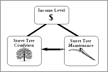 |
| Figure 1. Relationships between income and street tree condition and maintenance |
Chapter 2: Research Methods
This chapter provides an overview of the methodology used in this study. The first section describes the selection of the study area and how data was acquired from outside sources. The second section describes the tree sampling method–using Seattle’s GIS-based street tree inventory–and the tree condition assessment used for data collection. The third section explains the processing of Seattle’s tree crew work records, and the final section presents an overview of the analysis used to examine relationships in the data.
STUDY SITE
The City of Seattle, Washington was chosen as the study site for this project
due to the immense interest in the management and continuation of the city’s
urban forest resource - as reflected by the development of the transportation
department’s urban forestry program, the city’s 16-year Tree
City USA status, and the Mayor’s Urban Forest Coalition. Seattle boasts
a fairly extensive urban forest presence, with more than 80,000 street trees
and countless park, greenbelt, and backyard trees.
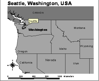 |
| Figure 2. Map of study site |
Seattle’s street trees are scattered throughout the entire city. Many
streets have planting strips, while the trees in higher density areas are planted
in square or rectangular planting areas, usually quite small. Trees in Seattle
have long growing cycles, due to the high levels of moisture during the rainy
season and brilliant sunshine during the summer.
Seattle is a medium-sized city, with a total population close to 570,000. The
city is topographically diverse, with many steep hills and valleys. The city
is long and narrow, approximately 4 kilometers across at its most narrow, 14
kilometers at its widest, and 27 kilometers from north to south. Seattle is
bordered by Lake Washington to the east and Puget Sound to the west. Seattle
is well known for its small neighborhoods, each with their own unique characteristics
and demographics. The areas in the northernmost and southernmost parts of the
city limits are more residential, with lower-density residential living, while
the areas in the mid-area are more developed and dense.
COMMUNITY PARTICIPATION: RECRUITMENT
In order to satisfy the requirements of participatory research methods, high
school students were recruited to participate in the project. Incorporating
high school students would introduce a group of young people to the often unfamiliar
field of urban forestry, provide a fresh insight into community resources and
social justice issues, and enhance the project with the perspective of young
Seattle residents. Students were recruited through visits and e-mails to high
school environmental clubs, science and humanities classes, and various environmental
educational organizations across Seattle. Figure 3 shows the flyer that was
used to attract students to the project. After a handful of visits and organizational
meeting, six students committed to work on the project for the duration of
the summer–after an initial interest of forty-six students. The students
were pertinent to the project, and their involvement was a testament to the
benefits of including community members in projects related to the health of
cities and urban residents.
![]()
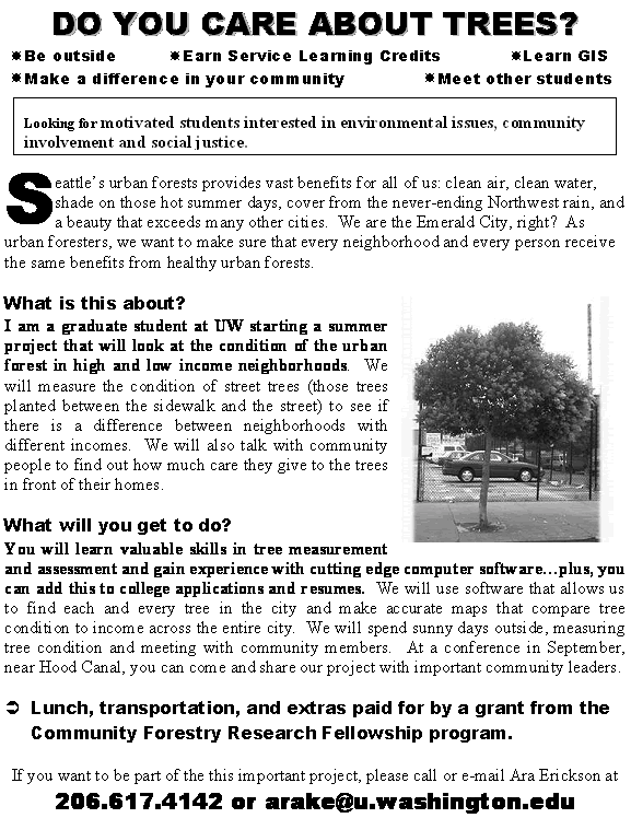 |
| Figure 3. Recruitment flyer |
DATA SETS
This project included substantial data reconnaissance and transformation. Census
information, from both 1990 and 2000, were combined and synchronized to classify
Seattle’s high- and low-income census tracts. The tree inventory map
data–used to select trees–was adjusted to work with a manageable
number of species and trees, and was aligned with census information for
accurate location and selection of the trees. The City of Seattle’s
street tree maintenance records involved an enormous amount of data entering
and recoding. In order to integrate the three types of data, months of data
transformation work was necessary. The steps taken to manage the data are
described, in further detail, in the following three sections. Table 1 lists
this project’s type and source of data1.
| Table 1. Data sets and sources |
| Data | Source |
| Census Information | |
| 2000 Demographic information | Custom tables via American FactFinder |
| 2000 Census Tracts GIS files | Geolytics CD-ROM |
| 1990 Demographic information | Geolytics CD-ROM |
| 1990 Census Tracts GIS files | Washington State Geospatial Data Archive (WAGDA) |
| Seattle GIS Information | |
| Street Tree Inventory, City of Seattle | City Arborist's Office - Department of Transportation |
| Tree Crew Work Records, City of Seattle | City Arborist's Office - Department of Transportation |
| City Boundary | WAGDA |
| Street Network - Streets and Intersections | City of Seattle via WAGDA |
|
|
1Full citations located at end of reference section, in the same order presented here.
STUDY AREA DATA CONTENT
Boundaries
Work began with locating 1990 and 2000 Census information for the Seattle area.
Census boundary files and associated median household income, population, and
ethnic make-up for each census tract in Seattle were downloaded via the U.S.
Census Bureau’s American FactFinder and the Washington State Geospatial
Data Archive (WAGDA). Census tracts are defined as small, relatively homogeneous
areas, with respect to economic status, and living conditions, into which large
cities and counties are divided (U.S. Census Bureau 1997). The GIS files were
projected in Geographic Projection, Decimal Degrees for Map Units, and NAD
83 Datum. Using 1990 and 2000 data, a check for consistency of Census tract
boundaries showed only five tracts dividing into two or more tracts between
the selected years. Therefore, it was decided that using the 2000 boundaries
would still provide accurate assessments of income for the areas from 1990
to 2000.
Areas that made up Seattle’s primary business and industrial land use
areas (i.e., downtown, Safeco Field, Seahawk Stadium, and Harbor Island) were
excluded from site selection. It was not appropriate to include non-residential
areas, as this study was aimed at exploring the differences in tree condition
between areas of diverse household, not commercial, income.
Comparison of income level between 1990 and 2000
Since tree condition is often a function of time, it was necessary to have
fairly consistent levels of income over a set-period of time. To ensure that
selected areas did not have above-average income increases or decreases in
the recent past, change in income level between 1990 and 2000 was calculated.
Using the following Consumer Price Index (CPI)2 formula,
1990 dollars were converted to 2000 constant dollars:
2000 MHI = 1900 MHI * (2000 CPI/1900 CPI)
where CPI for 1990=130.7 and 2000=172.2
On average, Seattle’s census tracts’ median household income increased by 24.76% (+/- 20.98) between 1990 and 2000. Fourteen tracts were excluded because their change in median household income from 1990 to 2000 was greater than 46% (one standard deviation from the mean)3.
![]()
|
|
2CPI
is a measurement that explains the change in the prices paid
by urban consumers for a representative basket of goods and services
from one year to another (reference). This means that the same
basket of goods that an urban consumer could by for $130.70 in
1990 would have to be purchased for $172.20 in 2000.
3Percent
change in median household income between 1990 and 2000 for Seattle’s
census tracts are listed in Appendix A.
Distribution of Median Household Income
Seattle’s census tracts showed a normal distribution of median household
income, with the majority of the tracts falling between $30,000 and $60,000
with an average median household income of $47,416 (+/- $16,000). Census tracts
were divided into “high” and “low” income groups: greater
than $47,416 and less than $47,416. Sixty-nine tracts were considered high-income,
while forty-nine tracts were considered low-income, equaling a total of 108
acceptable tracts to select study sites from.
Selected Tracts
Six census tracts were randomly selected from the 108 acceptable tracts in
the city– three of each income group. Median household incomes for
each of the six areas were compared against each other to ensure an adequate
distribution of income conditions. The selected tracts–from lowest
income to highest income–were matched with the following approximate
neighborhoods: the Central District, Fremont, Northgate, North Capitol Hill,
Seward Park, and Madrona areas. Table 2 provides demographic information
and total tree population for the six selected study areas. Additional information
for all census tracts within Seattle’s city boundaries, not just the
selected tracts, is presented in Appendix A.
| Table 2. Demographic information for selected areas |
| Area | Census Tract # |
Median Household Income |
Population | Ethnicity | Housing Characteristics |
Total Number of Trees |
|
| Low-income | Central District | 90 | $20,104 | 2134 | 19% White 30% African American 43% Asian |
Apartments, Duplexes | 407 |
| Northgate | 12 | $32,463 | 6106 | 66% White 17% Asian |
Single-family homes, duplexes | 449 | |
| Fremont | 49 | $38,858 | 5525 | 88% White | Apartments, single-family homes, duplexes, | 751 | |
| High-income | North Capitol Hill | 65 | $52,838 | 4045 | 88% White | Large single-family homes | 1095 |
| Seward Park | 102 | $60,125 | 4870 | 51% White 19% African American 22% Asian |
Single-family homes, duplexes | 351 | |
| Madrona | 78 | $82,635 | 5097 | 72% White 20% African American |
Single-family homes | 1054 |
A map of where the tracts are located in Seattle is shown in Figure 4. Northgate and Fremont are in the north, Seward Park is furthest south, and North Capitol Hill, Madrona, and the Central District are in the middle of the city and closest to downtown.
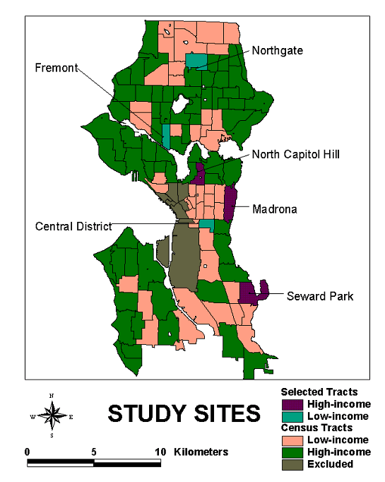 |
| Figure 4. Map of study sites |
TREE SAMPLE DATA
CONTENT
Street Tree Inventory
The City of Seattle’s GIS-based Street Tree Inventory, generously provided
by the City Arborist’s Office, was used as the data source for the tree
sample. Although this inventory could be considered rather static (not used
on a daily basis), the City Arborist’s Office makes relatively frequent
updates and has added more than 10,000 trees to the database since the original
inventory done in 1990 (Rundquist 2003). Each street tree is geocoded to a
particular address and location in Seattle and includes information about species,
size, planting location, planting date, management responsibility, and more.
The full database includes more than 75,000 street trees.
Species
Seattle is known as the “Emerald City”–a testament to the
abundant green vegetation that adorns the parks and hills of the city. Having
close to 500 different tree species, Seattle’s streets are no exceptions
to the diversity of the city’s natural landscape. Due to the enormous
task of training the high-school students in tree identification and condition
assessment for such a large number of species, it was necessary to limit the
number of tree species that would be part of this study. Therefore, tree species
that amounted to less than 0.5% of the total street tree population were excluded
from the tree sample. This reduced the number of tree species from 500 to 41–a
much more manageable number of species.
Using ArcView, the tree inventory shapefile was “clipped”–similar
to using a cookie cutter to cut out pieces of dough–to include only those
trees that made up more than 0.5% of the total street tree population. The
inventory was further clipped to include only the trees that fell within the
six selected tracts, resulting in a total of 4107 trees. Systematic random
sampling was used to select forty trees from each of the six tracts, for a
total tree sample of 240.
Table 3 shows the fifteen most common tree species on Seattle’s streets,
and their composition of the total street tree population. Forty-one additional
species, not listed in the table, made up the remaining trees that represented
more than 0.5% of the total street tree population.
![]()
| Table 3. Composition of Seattle's 15 most common street tree species |
| Rank | Common Name | Scientific Name | Percent |
| 1 | English midland hawthorn | Crataegus laevigata | 4.60%
|
| 2 | Norway maple | Acer platanoides | 4.20%
|
| 3 | Blireiana purpleleaf plum | Prunus x blireiana | 3.90%
|
| 4 | Red maple | Acer rubrum | 3.80%
|
| 5 | Thundercloud purpleleaf plum | Prunus cerasifera 'Thundercloud' | 3.70%
|
| 6 | Kwanzan flowering cherry | Prunus 'Kwanzan' (Sato Zakura Group) | 3.70%
|
| 7 | Sweetgum | Liquidambar styraciflua | 3.60%
|
| 8 | Myrob flowering plum | Prunus cerasifera | 2.80%
|
| 9 | Apple/crabapple | Malus sp. | 2.80%
|
| 10 | European white birch | Betula pendula | 2.20%
|
| 11 | Littleleaf linden | Tilia cordata | 2.20%
|
| 12 | Double chinese cherry | Prunus serrulata | 2.20%
|
| 13 | Red oak | Quercus rubra | 1.80%
|
| 14 | London plane | Platanus x acerifolia | 1.70%
|
| 15 | Japanese maple | Acer palmatum | 1.50%
|
Tree Condition Rating
The Council of Landscape and Tree Appraisers Tree Assessment Guide includes
a tree condition rating as part of the total assessment method (Council of
Tree and Landscape Appraisers 1983). The condition assessment separates a
tree into five factors: roots, trunk, scaffolding branches, smaller branches
and twigs, and foliage. Figure 5 depicts a tree with lists of the characteristics
used to gauge the level of problems associated with each of the five factors.
When assessing the condition of a tree, each factor is looked at separately;
using the characteristics in Figure 5 as guidance, each factor is assigned
a score based on if the characteristics present on the factor are positive
or negative. The following scores match the appropriate description of the
level of problems (or lack of problems) associate with each score:
1 = extreme problem
2 = major problem
3 = minor problem
4 = no apparent problem
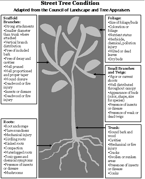 |
| Figure 5. Tree condition assessment criteria |
The five scores are then summed together to get one final condition score,
with five (5) being the worst possible score and twenty (20) being the best.
Consistent with the method used by the USDA Forest Service, Center for Urban
Forest Research, and many other urban forestry professionals, scores were
divided into four categories: dead or dying, poor, fair, and good. Table
4 lists the condition categories and their associated sums of the factor
score and characteristics.
| Table 4. Tree condition categories |
| Sum of Five Factors | Condition Category | Condition Number | Characteristics |
| 8-May | Dead or Dying | 1 | •Dead, or death imminent, from disease or other causes |
| 12-Sep | Poor | 2 | •General state of decline •May show severe mechanical, insect, or disease damage, but death not imminent •May require major repair or renovation |
| 13-16 | Fair | 3 | •Average condition and vigor for area •May need corrective pruning or repair •May lack desirable form characteristic of species •May show minor insect injury, disease, or physiological problem |
| 17-20 | Good | 4 | •Healthy vigorous tree •No signs of insect, disease, or mechanical injury •Little or no corrective work required •Form representative of species |
![]()
Reliability Test of Condition Rating
The tree condition assessment technique relies on professional judgment, is
highly reliable, and other experts would repeat very similar condition levels
using the same method. Additionally, the technique is not “sensitive,” meaning
that it does not give variable results depending on species or age. The assessed
condition of twelve trees was compared with a Certified Arborist’s
assessments of the same trees, using the same described method, and the results
showed a high level of reliability (Number of Cases = 12, F= 2.20, Reliability
coefficient Alpha = 0.9242). The sample did not stratify by tree age or species
because condition assessment does not compare older trees to younger trees
or one different species to another species; it looks solely at a particular
species at a particular age. However, the assessor must be familiar enough
with the species to know the characteristics of a “perfect” specimen
as well as common problems associated with that particular species.
Tree Condition Assessment – Data Collection
Data collection was performed between June 15 and August 1, 2003. Spreadsheets
were created with a list of the selected trees for each area and maps, created
in ArcView GIS, assisted in locating the exact location of a specific tree.
Thirty-six trees were missing, recently removed, or incorrectly listed. Diameter
(DBH), planting width, planting area type, and planting area ground cover were
also recorded. If more than one tree of the same species was present at the
specified address, a tree was chosen at random. If the specified tree was not
found at the address provided, either a nearby tree of the same species was
selected or it was noted that the tree was missing.
COMMUNITY PARTICIPATION: DATA COLLECTION
The students participating in the project were trained in tree identification
and basic tree condition assessment. Using tree identification books and printouts
of each tree species, the selected trees’ species were verified in the
field. For tree condition, “cheat sheets” and diagrams (similar
to Table 4 and Figure 5) were used to guide the students in the correct direction
when gauging tree condition. In order to maintain consistency and accuracy
throughout the entire project, the primary researcher was always part of the
assessment team and assured that the appropriate condition scores were assigned.
The experience was valuable for both the students and the project; the students
gained new skills and the project was rewarded with knowing that students enjoyed
the experience, as evident by the submission of the following poem from one
of the students:
Standing tall and majestically,
Deep olive and light green hues contrasting against
The azure blue sky with white wisps,
Summer smells still in the air,
Sun burning down upon leaves,
Shadows cast down,
Stopping
Notepad in hand
To meticulously write measurements,
Side note to self: unusual number of tumors on bottom trunk
As you move on to the next tree.
TREE MAINTENANCE
DATA CONTENT
Work Records
Beginning in March 1998, the City’s tree crew reports weekly “accomplishments” to
the City Arborist. The weekly reports describes where the tree crew went, what
type of tree care activity was performed, and how many of what tree species
were worked on. Seattle’s Arborist Office generously provided all of
the work records through December 2002. The total number of weekly accomplishments
equaled 250 individual files, approximately one for each week between March
1998 and December 2002.
The “accomplishments” from each file were consolidated into a single
spreadsheet and each entry included a unique ID, date, address (or intersection),
type of tree work, number of trees worked on, and type of tree(s) worked on.
The end result was a database with 1236 individual entries of tree maintenance
performed between 1998 and 2002. Examples of these entries are shown in Table
5.
| Table 5. Example of work records entry |
| Unique ID | Date | Address | Activity Main | Number of Trees | Tree Species |
| 145 | 5/6/2002 | 1833 S Dearborn St | Tree removal | 1
|
Kwansan Cherry |
| 203 | 5/13/2002 | 21st S & Norman | Routine pruning | 15
|
Tulip and Crabapple |
![]()
Each entry was matched to a location on the City’s Street Network shapefile, using with ArcView’s “geocode addresses” function. The “batch match” method resulted in 563 individual “events” matched with a 75-100% accuracy and 511 events matched with a 50-70% accuracy rate. An interactive match (not automatically done by the software) located 97 additional events and 64 events were unable to be matched at all. The end result was a GIS shapefile with 1171 separate work events, spanning the entire time period of recorded weekly accomplishments. The total of the work events were matched with the six areas and a new file was created to include the work events that fell within the boundaries of the areas.
ANALYSIS PROCEDURES
Tree Condition and Income
Tree condition was analyzed using the Statistical Package for Social Sciences
(SPSS), Microsoft Excel, and ArcView GIS. Average tree condition was calculated
for each of the six tracts, using the condition number (1-4) associated with
each condition category (poor, fair, etc.). A OneWay ANOVA test was used to
compare the mean condition across all tracts and an Independent Sample T-Test
was used to compare the mean condition between the aggregated high and low-income
areas (the six tracts were collapsed into one high-income variable and one
low-income variable, resulting in a comparison of two variables).
The mapping of tree condition and work records across the city was deemed an
important visual display, enabling city managers and decision makers, unfamiliar
with urban forestry terms, to use visually displayed data to assess current
patterns in management and make appropriate decisions. Maps displaying tree
condition in the different areas were also produced. Relevant to the goals
of this study, one author writes:
As a basis for planmaking, revelations about who benefits, presented in visual, spatially-oriented terms, enable communities to evaluate their distributional preferences and see whether or not they are in line with broader community goals and with notions of fairness (Talen 1998).
Work Records and Income
The distribution of tree maintenance (total visits and total number of trees
worked on) was calculated for the entire city (See Appendix B), for each
of the six tracts, and for the high and low-income areas. Total number of
visits and number of trees worked on (from 1999-2002) were compared between
the six areas and the aggregate low and high-income areas. Additionally,
the type of activity performed at each location (pruning, removing, etc.)
was calculated for the entire city (see Appendix B).
Work records from 1998 began in March and were slightly incomplete, thus were
eliminated from analysis. Additionally, the number of visits and trees worked
on were weighted by total street tree population and total city-maintained
trees, to ensure an accurate comparison of tree maintenance in relation to
the actual number of trees present and the number of trees under City responsibility4.
Work Records and Condition
Average tree condition among each area and between the high and low-income
areas was graphed in relation to the number of visits and number of trees worked
on per visit. Although this information is not adequate enough for robust analysis,
a basic relationship between maintenance and average tree condition of the
sampled trees can be detected with graphs and presented in tables. This information
is presented in the Results section alongside the tree maintenance and income
findings.
4Trees
were weighted by total-city maintained trees due to an interesting,
yet common, practice of tree responsibility in cities strapped
for funding. The City Arborist Office, part of the Department
of Transportation, manages Seattle’s street trees with
help from Seattle City Light, the utility company, and Parks
and Recreation. All city trees are considered publicly owned,
but responsibility of the trees is often in the hands of the
adjacent property owner. Unless the city physically planted the
tree, the property owner is responsible for any pruning, removal,
or costs associated with damage of the tree. However, the property
owner still does not “own” the tree; they must apply
for a tree work permit through the City Arborist, pay a $265
refundable fee, and have the final work inspected by the City.
If the work is not up to standard, the fee is not refunded.
City planted trees, on the other hand, are the responsibility of the City Arborist’s
Office – who only has one permanent tree crew, made up of two or three
people. Most of the City maintained trees are located on the main arterial
streets and commercial districts throughout Seattle. The one exception is a
large part of the Central District; in the 1970’s the Federal Government
funded a program called “Forward Thrust,” aimed at encouraging
development and improvement in low-income areas. Seattle used a large part
of that money to plant a large number of street trees in one of its poorer
neighborhoods. Thus, the City is responsible for the maintenance of those trees.
Although the City is not responsible for maintaining trees other than the ones
they plant, the City tree crew will respond to occasional pruning requests,
tree removal, and clean-up/clearing needs in neighborhoods throughout Seattle.
![]()
Other Factors
In order to ensure the validity of the findings, it was necessary to investigate
if other factors were contributing to the average condition in the different
areas. Although soil quality and type, air pollution levels, and precipitation
levels could contribute to different tree conditions, they were outside the
scope of the project. Nevertheless, the effect of tree diameter, genera,
and planting strip width and cover on tree condition was analyzed.
Chapter 3: Results
This chapter presents the results from the tree condition assessment and the tree work records analysis. First, it compares the tree condition assessed in this study to the condition assessed in the City’s 1994 inventory. The second section reports average tree condition as it related to income and the third section reports the level of tree care as it related to income and tree condition.
COMPARISON OF SAMPLED TREES’ CONDITION
AND CITY INVENTORY
With more than 98,000 street trees, Seattle boasts many tree-lined streets.
However, the condition of the street trees varies. As shown in the Figure 6,
this study found that approximately 23% of the sampled street trees were in
good condition and 65% were in fair condition, with 12% of the trees in poor
and dead or dying condition. Similar to the above percentages, calculations
of tree condition from the entire inventory (N=70,023) showed that condition
results from this study did not vary widely from the condition assessments
performed by the City in their 1994 inventory5.
This similar pattern of street tree condition between the two assessments was
important to the reliability of this project’s findings as it increased
the possibility of extending to the rest of Seattle.
5 In the original inventory, the City Arborist assigned condition values from 1-5 for each tree. For comparison to this study, the numbers were translated as follows: 1 = Dead or dying; 2 = Poor; 3 or 4 = Fair; 5 = Good.
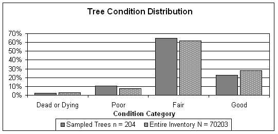 |
| Figure 6. Tree condition distribution |
IS TREE CONDITION RELATED
TO INCOME LEVELS?
Tree Condition in Six Tracts
Surprisingly, as Figure 7 shows, the six areas shared very similar mean street
tree condition levels. Moreover, mean street tree condition showed no significant
relationship to income; tree condition neither increased nor decreased with
median household income6.
Figure 7 shows the absence of any statistical relationship between median household
income and average tree condition; the line is relatively flat across all income
levels and the average condition scores do not vary by median household income.
6 One-Way ANOVA results = Sum of Squares = 1.617, df = 5, F=0.7598, p > 0.5
![]()
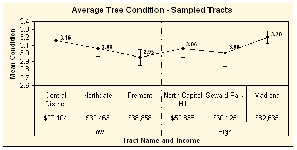 |
| Figure 7. Average tree condition in sampled tracts compared by income levels |
Condition Categories in Six Tracts
Figure 8 shows the percent of trees in the different condition categories for
the six areas. The majority of the trees were in fair condition, with good
being the second most common condition of trees. A Chi-Square Test performed
on the distribution of tree condition categories showed no significant difference
in distribution among the six tracts (Pearson Chi-Square Value = 15.129,
df = 15, p > 0.4).
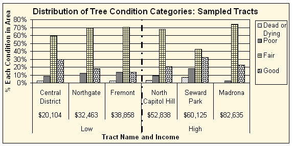 |
| Figure 8. Distribution of tree condition categories in sampled tracts |
Tree Condition in Low and High-Income Tracts
Similar to the results from the tract-by-tract analysis, average tree condition
was not significantly different between the aggregated high and low-income
areas (Figure 9). The high-income areas’ average tree condition was
3.09 (standard deviation = 0.6783), while the low-income areas’ average
tree condition was 3.06 (standard deviation = 0.6269). A t-test performed
on these means showed no significant difference between the two income areas,
thus the null hypothesis could not be rejected7.
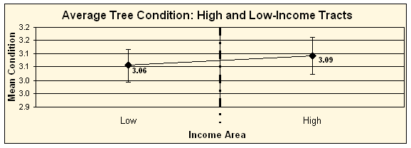 |
| Figure 9. Average tree condition for high and low-income areasCondition Categories in Low and High-Income Tracts |
![]()
CONDITION CATEGORIES
IN LOW AND HIGH-INCOME TRACTS
Figure 10 shows that there was little to no difference in the patterns of tree
condition distribution of between the high and low-income areas8.
Although the high-income areas had slightly more trees in good and poor condition
and slightly less trees in fair condition, the difference between the income
groups was insignificant.
7 t
= -0.4001, df = 195.88, p > 0.6
8 (Pearson Chi-Square Value = 0.9853,
df = 3, p > 0.8)
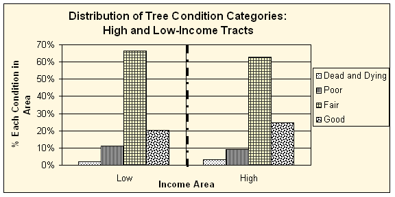 |
| Figure 10. Distribution of tree condition categories for high and low-income areas |
Visual Display of Tree Condition
Figure 11 is a map displaying tree condition across all sampled tracts. Tree
icons in four different colors represent the tree condition categories: dead
or dying, poor, fair, and good. The tracts on the right-hand side, with purple
backgrounds, are the three high-income areas and the tracts on the left-hand
side, with green backgrounds, are the three low-income areas. At first glance,
this visual representation of tree condition does not show any obvious distinctions
in color patterns – nor tree condition - among the different areas.
There is a large presence of yellow and green trees scattered throughout
all of the areas, with no particular differences in location. On the other
hand, there are a larger number of red and orange colored trees in Seward
Park – one of the lower average tree condition tracts. This tool can
be useful for managers to notice subtle patterns of tree condition throughout
a city, rather than needing to decipher complicated numbers and charts.
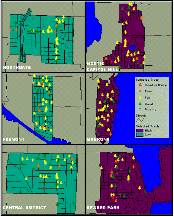 |
| Figure 11. Map of tree condition |
ARE LEVELS OF
TREE MAINTENANCE RELATED TO INCOME AND/OR TREE CONDITION?
This section presents the results from the tree crew work records. Tree maintenance
among the six tracts is discussed first and the aggregated high and low-income
areas are discussed second. For simplicity and to avoid repetitiveness with
the graphs, the testing of the relationship between tree maintenance and tree
condition is presented alongside the maintenance and income data.
Tree Maintenance in Six Tracts
Earlier, it was shown that average tree condition neither differed significantly
between the different income groups nor among the six different areas. Table
6 shows the average tree condition of each area as well as the total number
of visits and total number of trees worked on between 1999 and 2002. The first
three areas, the low-income areas, tended to have a greater number of trees
worked on and a greater number of total visits than the last three areas, but
mean tree condition tended to stay the same. The table also shows the total
number of trees and total number of city-maintained trees for each area. The
three low-income areas have a much higher proportion of city-maintained trees
than the high-income areas, but trees per hectare does not display a pattern
in relation to income.
![]()
| Table 6. Work record information for six areas |
| Tract Name | Average Condition | Hectares | Total Trees | City Trees | Trees/ Hectare |
Visits | Trees Worked On |
|
| Low-income | Central District | 3.16
|
83.25
|
407
|
231
|
4.8892
|
21
|
57
|
| Northgate | 3.06
|
187.89
|
449
|
295
|
2.3897
|
19
|
37
|
|
| Fremont | 2.95
|
108.99
|
751
|
217
|
6.8903
|
26
|
107
|
|
| High-income | North Capitol Hill | 3.06
|
112.62
|
1095
|
32
|
9.7228
|
8
|
13
|
| Seward Park | 3
|
278.82
|
351
|
1
|
1.2589
|
1
|
2
|
|
| Madrona | 3.2
|
213.18
|
1054
|
194
|
4.9442
|
21
|
21
|
For analysis, the data was weighted by total number
of trees in each area and total number of city-maintained trees
to ensure equal comparison of tree work in relation to the total
number of street trees. Data was also weighted by size of tract
(hectares), but results did not vary from the weighting by tree
total, so results from this analysis are not discussed.
As shown in Table 7, the Central District, Fremont, and Northgate areas had
the greatest number of trees worked on per the total number trees, approximately
0.14, 0.21, and 0.19 respectively, while North Capitol Hill, Madrona, and Seward
Park showed significantly less number of trees worked on per total trees, 0.02,
0.05, and 0.02 respectively. The number of visits per total trees did not show
quite as large of difference between the areas but followed a similar proportional
pattern. Figure 12 clearly shows that the level of tree care was greater in
the three low-income areas, while mean tree condition stayed the same among
all of the areas.
| Table 7. Number of visits and number of trees worked on in six areas |
| Tract Name | Visits per total trees |
Percent of all visits |
Trees Worked On per total trees |
Percent of all trees |
| Central District | 0.0516
|
24.90%
|
0.14
|
22.30%
|
| Northgate | 0.0646
|
31.10%
|
0.2094
|
33.30%
|
| Fremont | 0.0426
|
20.50%
|
0.1864
|
29.70%
|
| North Capitol Hill | 0.0146
|
7.00%
|
0.021
|
3.30%
|
| Seward Park | 0.0142
|
6.90%
|
0.0513
|
8.20%
|
| Madrona | 0.0199
|
9.60%
|
0.0199
|
3.20%
|
| Total | 100.00%
|
100.00%
|
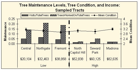 |
| Figure 12. Tree maintenance (per total trees): sampled tracts |
A slightly different pattern emerged when the data was weighted by total number of city-maintained trees - the amount of maintenance appeared to shift to the three high-income areas (Table 8 and Figure 13). The Central District and Northgate no longer had higher levels of tree care, rather they showed the lowest number of visits and trees worked on per total city maintained trees. However, Seward Park, with one city maintained tree and one unweighted visit, appeared to receive 84.1% of the visits; thus, this analysis is inadequate if the areas have extremely low numbers of city maintained trees. Figure 13 shows that low and high-income tree care did not follow the same pattern as previously displayed; North Capitol Hill and Fremont had high levels of tree care, while the Central District, Northgate, and Madrona had much lower levels.
![]()
| Table 8. Work levels per total city trees for six areas |
| Area Name | Visits per total city trees | Percent of all visits | Trees Worked On per total city trees | Percent of all trees |
| Central District | 0.0909
|
1.50%
|
0.2468
|
1.20%
|
| Northgate | 0.0983
|
1.70%
|
0.3186
|
1.60%
|
| Fremont | 0.1475
|
2.50%
|
0.6452
|
3.20%
|
| North Capitol Hill | 0.5
|
8.40%
|
0.7188
|
3.60%
|
| Seward Park | 5
|
84.10%
|
18
|
89.80%
|
| Madrona | 0.1082
|
1.80%
|
0.1082
|
0.50%
|
| Total | 100.00%
|
100.00%
|
 |
| Figure 13. Tree maintenance
(per total city trees): sampled tracts Seward Park was excluded from the graph due to inadequate data |
Tree Maintenance in Low and High-Income Areas
Similar to the results from each the six areas, the number of visits and number
of trees worked on were higher in the low-income areas than the high-income
areas (82 and 42 compared to 291 and 62), but the average condition did not
significantly change. Table 9 also shows that the low-income areas have fewer
trees than the high-income areas, but a greater proportion of city-maintained
trees.
| Table 9. Tree and work information for low and high-income areas |
| Income Group | Mean Condition | Hectares | Total trees | City trees | Trees/ha | Visits | Trees Worked On |
| Low | 3.06
|
380.132
|
1607
|
743
|
4.2275
|
82
|
291
|
| High | 3.09
|
604.618
|
2500
|
227
|
4.1348
|
42
|
62
|
Table 10 shows this same information weighted by total trees. The low-income areas received 75.2% of the total visits and 88% of the total trees worked on, compared to the high-income areas which only received 24.8% and 12% respectively.
![]()
| Table 10. Visits and trees worked on per total trees |
| Income Group | Visits per total trees | Percent | Trees Worked On per total trees | Percent |
| Low | 0.051
|
75.20%
|
0.1811
|
88.00%
|
| High | 0.0168
|
24.80%
|
0.0248
|
12.00%
|
| Total | 100.00%
|
100.00%
|
Figure 14, once again shows that the high-income areas received less overall tree care than the low-income areas, while average tree condition stayed relatively the same.
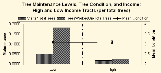 |
| Figure 14. Tree maintenance (per total trees): high and low-income |
Once again, a very different pattern emerged when the data was weighted by the number of city-maintained trees (Figure 15). The high-income areas received a greater percentage of visits than the low-income areas, and only a slightly lower number of trees worked on. The low-income areas received only 37.4% of all visits per city trees, compared to the high-income areas that received 62.6% of all visits. However, the low-income areas still received more trees worked on per city trees, 58.9%. Figure 15 shows the apparent increase of visits and trees worked on for the high-income areas when weighted by number of city trees in each area.
| Table 11. Visits and trees worked on per City trees |
| Income Group | Visits per City Trees | Percent | Trees Worked On per City trees | Percent |
| Low | 0.1104
|
37.40%
|
0.3917
|
58.90%
|
| High | 0.185
|
62.60%
|
0.2731
|
41.10%
|
| Total | 100.00%
|
100.00%
|
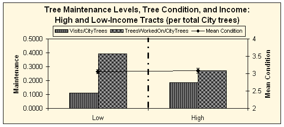 |
| Figure 15. Tree maintenance (per total city trees): high and low-income |
Visual Display of Tree Maintenance
Figure 16 displays tree maintenance patterns in the six tracts. Each “dot” represents
an individual visit and the size of the dot is dependent on the number of
trees worked on for the specific visit – the larger the dot, the more
trees. As the map shows, the larger dots are much more frequent in the three
low-income areas than the three high-income areas. Once again, this can be
a valuable tool for urban forest managers to use when wanting to get an informational
snapshot of where their tree maintenance efforts are being directed or patterns
undetected on paper.
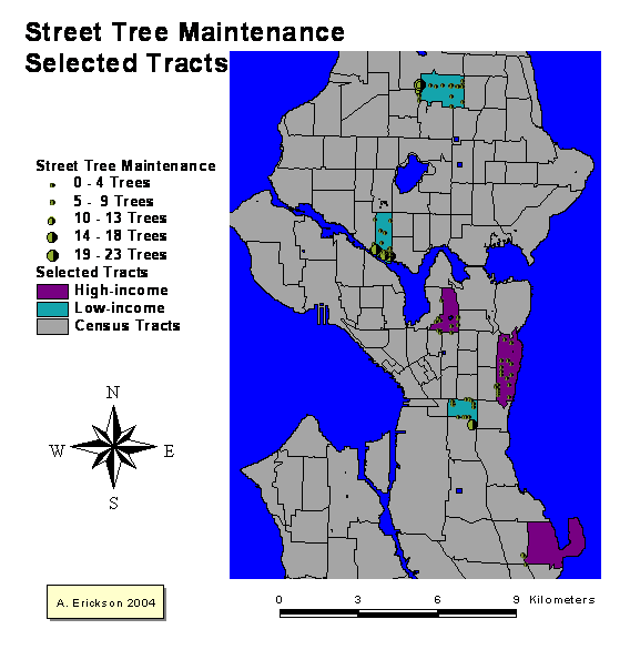 |
| Figure 16. Map of tree maintenance |
![]()
OTHER FACTORS
Table 12 shows the other factors, recorded during the tree condition assessment
phase, which were compared to tree condition, income, and tree maintenance.
The results from a general investigation into these additional factors that
could be related to tree condition showed no other notable explanations for
the relationships discussed earlier. A matrix was plotted in SPSS (Statistical
Package for Social Science), and not patterns were detected that could provide
alternative explanations for the assessed tree condition.
| Table 12. Additional factors |
| Factor | Description |
| Genus | Eight most common genera |
| Tree location | Planting strip/sidewalk cutout |
| Planting strip type | Grass/mulch/soil |
| Planting strip width | Meters |
| Tree ownership | City/private |
COMMUNITY PARTICIPATION:
NEW SKILLS
It is beneficial for both the project and the participants to include community
members in a project. The project gains the expertise and insight from members
of the community, especially valuable when dealing with a resource as visible
as street trees, as the participants learn new skills and can gain a sense
of ownership and responsibility for the resource. The following quote is from
one of the students who participated in the project and describes her newly
found skill in tree identification and hints at a future sense of responsibility
and care for urban trees.
“ Before I volunteered for this project to study the urban forest, I knew nothing about trees. I seriously could not tell a maple from an ash. In helping with this project, I learned to tell if a tree was actually healthy or not. To this day, I am still seeing trees and mentally noting their leaf color, visible damages, tumors, etc. I am beginning to notice the physical aspect and health as well as the beauty in trees.”
Chapter 4: Discussion
This chapter will discuss the results from Chapter Three and provide
explanations for the detected relationships between tree condition,
income level, and tree maintenance. There is no single explanation
for the equal levels of tree condition and the higher levels of
tree maintenance in the low-income areas; rather, it is likely
that different factors interact with each other to form the detected
patterns – as with most events involving a number of players
and circumstances. The diagram below, Figure 17, provides a visual
tool to reference back to throughout the Chapter. The arrows represent
the possible effect on tree condition (higher or lower) of each
factor. For example, City tree maintenance results in an increased
average tree condition, but the increase is higher in the low-income
areas than the high-income areas.
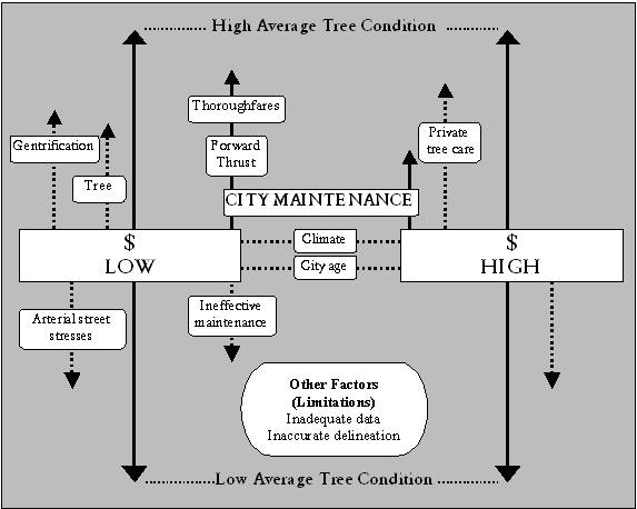 |
| Figure 17. Factors affecting average tree condition between high and low-income areas |
![]()
TREE CONDITION AND INCOME
There are a number of reasons why the relationship between condition and income,
is not as hypothesized at the beginning of this project. The following section
discusses some of the possible reasons for equal levels of tree condition
shown from this study, such as tree age, city age, favorable climate, and
inaccurate income boundaries.
Tree age
In the studied tracts, the youngest and oldest trees were typically in the
worst condition. Out of all of the trees sampled, the higher-income areas had
the majority of the oldest and youngest trees, while the lower-income areas
had most of the mid-age trees, which were in noticeably better condition than
both the young and old trees. It appears that the higher-income areas’ conditions
were influenced by the distribution of tree age and the presence of the majority
of the young and old trees, while the lower-income areas had mostly mid-age
trees. This distribution of tree age most likely resulted in a balancing of
average tree condition between the high and low-income areas.
One of the higher-income tracts, North Capitol Hill, was significantly older
than the other tracts and had a much more established street tree population.
The older trees often had signs of major limb breakage, rotten trunks and branches,
and many dead large branches. On the other hand, Seward Park, another higher-income
tract, was mostly devoid of any substantial tree populations. It looked as
if the neighborhood participated in a recent tree planting effort, but the
young trees did not fare very well. Many of the newly planted trees were either
planted incorrectly or not watered enough during those important first years
of growth; the result being trees either already dead or quickly on their way
to dying.
Compared to the higher-income tracts, the lower-income tracts had many more
mid-size trees, in the 20-30 year range. These mid-size trees were often in
better condition than the older or younger trees. Although many of the trees
in Northgate had numerous swellings and other signs of distress, most of the
trees in Fremont were growing in very small spaces, and the trees in the Central
District were experiencing a large insect infestation, the overall average
in the these tree low-income areas was similar to the higher-income areas.
City age
The argument was just made that the distribution of tree age may have caused
the results to show that there was not a difference in average tree condition
between the high and low-income areas. It could also be argued that since Seattle
is a relatively young city, there is less of a range of tree age when compared
to older cities in the Northeast and Midwest of the United States. With less
range of tree age, there is more likely less range of tree condition.
Favorable climate
A third contributor to the apparent equal tree condition across the income
groups may be that Seattle’s trees are fortunate to have a favorable
growing climate, and less stresses, than other cities. With a moderate weather
pattern and infrequent to no freezing temperatures, hurricanes, and extreme
heat, trees may not experience some of the same stresses that other city trees
are faced with. Thus, tree condition may not differ across the entire city,
as trees are growing fairly well, even with minimal maintenance and care.
Inaccurate delineation of neighborhood income level
Delineating income boundaries was a difficult and possibly imprecise procedure.
Income data from the Census is not a 100% sample, but a representative sample
of only part of the population. Although the selected census tracts were meant
to be homogenous in income and race, they occasionally included areas that
were distinctly different than neighboring blocks and households. This was
most apparent in Seward Park, where part of a low-income area was grouped into
a census tract designated high-income. This disparity may have resulted in
inaccurate income delineation, and an incorrect comparison of tree condition
between high and low-income areas.
Limiting factors
Lastly, it is possible that limitations of this study may have resulted in
the insignificant difference in tree condition. Tree condition may have been
assessed incorrectly, or with too much of a subjective measurement. The tree
sample (204) may not have been large enough – this study could have benefited
from a much larger tree sample. Or, the selected tracts may not have had distinct
enough income levels; the results may have been very different if extreme (polar
opposite) areas of income were used, rather than a range of high and low-incomes
that was used in this project.
![]()
TREE MAINTENACE AND INCOME
The comparison of tree maintenance records between the different income areas
showed that the low-income areas were receiving much more attention than
the high-income areas. There are a variety of explanations for this occurrence,
mainly that the low-income areas have most of the main thoroughfares in the
Seattle, thus increasing the City’s level of responsibility for those
areas’ street trees.
Thoroughfares
Many of the sampled trees in Fremont, Central District, and Northgate were
located on main thoroughfares, which most likely garnered more attention from
the City because of traffic clearance and safety issues as well as an increased
chance of City ownership and responsibility. On the other hand, the higher-income
areas were mainly small residential streets, with few main thoroughfares. It
appeared that most of the street trees in the higher-income areas were selected
and cared for by the home owners adjacent to the planting strip, rather than
the City.
The fact that the lower-income areas have more main streets, and thus receive
more tree maintenance, may be a different sort of environmental justice issue.
During past transportation planning, it was common that lower-income and areas
with ethnic minorities were displaced with major transportation corridors.
It may have been difficult for these areas to resist the disruptive streets,
due to lack of political clout and resources, but they now have public trees
as compensations.
Forward Thrust
Between 1968 and 1978, Seattle experienced a rush of funding from a series
of voter approved bonds called Forward Thrust; money was allotted for such
things as neighborhood improvements, a new aquarium, park development and maintenance,
and a large street tree planting effort in low-income and deteriorating neighborhoods.
Thirty years later, many of these neighborhoods now have a substantial street
tree population, all under the City’s responsibility. This could be one
explanation for the much larger proportion of City tree maintenance directed
towards lower-income areas. The driving force for tree maintenance decisions
could be a result of the Forward Thrust efforts, rather than neighborhood income
levels. Coincidentally, the Central District is one of the neighborhoods that
was slated for neighborhood improvements and had many trees planted in the
1970s.
Inadequate Data
Once again, the limitations of this study may have affected the results of
the comparison between maintenance and income levels. Caution must be used
when looking at the tree maintenance levels when weighted by City maintained
trees. Although it would be useful to see how many visits an area received
in proportion to the number of trees the City is responsible for, Seward Park
was an example of when there was inadequate data to conduct robust analysis.
Seward Park only showed a handful of City owned trees and had a total of two
visits from the City, showing that close to 100% of the visits were in this
area. When compared with an area with 100 City trees and 50 visits, (only 50%
of the trees visited), it looks as if Seward Park is receiving more care – when
in fact this is not the case.
Gentrification
One final explanation of the difference in tree maintenance between the high
and low-income areas is the possibility that Seattle’s recent and rapid
gentrification of many low-income areas has resulted in more attention in these
low-income areas. The high levels of renewal action may be attracting (or even
demanding) more City attention to deal with increased citizen efficacy in communicating
public needs and requests.
![]()
TREE CONDITION AND MAINTENANCE
If the theory is correct that better maintained trees are in better condition,
then there should be a positive relationship between maintenance and condition.
However, this research found that as maintenance increased among the six
areas, average tree condition stayed relatively the same.
Climate
As discussed earlier, the Pacific Northwest’s moderate climate makes
for excellent growing conditions – and a possible reason why tree maintenance
does not necessarily affect tree condition. Seattle’s street trees may
not need as much maintenance as in other parts of the country due to the favorable
climate and lack of stresses like frequent ice storms, freezing weather, long
droughts, and hurricanes. This does not imply that tree maintenance is not
necessary in Seattle; on the contrary, tree maintenance is crucial to extending
the life of many of the young trees as well as maintaining a safe and hazard-free
tree population.
Ineffective maintenance
Another explanation is that the City tree crew’s current level of maintenance
may not be making a measurable difference in average tree condition in the
sampled tracts. As alluded to in Chapter 1, the City’s urban forestry
program is operating mainly with a “crisis management” approach.
The lack of routine pruning and scheduled maintenance may be taking care of
the hazards and major street tree problems, but may not contribute to a general
increase of tree condition in the areas served by the City.
Stresses from arterial streets
Reflecting on the fact that the low-income areas have more thoroughfares than
the high-income areas, it could be possible that the trees in the low-income
areas are experiencing an increase in the amount of stresses, such as air pollution,
damage from traffic, and vandalism, from the main arterials. The effect of
these stresses could be lowering the average tree condition, but when complemented
with the higher levels of tree maintenance, average tree condition is equal
between high and low-income areas.
Private tree care
The most compelling possibility for the equal tree condition yet different
levels of tree maintenance between the low and high-income areas is that the
residents of the higher-income areas are supplementing street tree maintenance
with either their own tree care or by hiring private arborists or tree care
companies. This additional tree maintenance could be resulting in an equaling
of total tree maintenance between the two income areas – and a balancing
of average tree condition.
![]()
COMMUNTIY PARTICIPATION: SURVEY
RESULTS
After six weeks of gathering street tree condition information, and observing
patterns of tree care and condition, the assessment team contemplated that
one possibility in the undetected difference in tree condition was that the
trees in the higher-income areas were displaying evidence of more routine tree
care from what appeared to be the residents of the adjacent property. Interested
in if this thought was accurate, the students carried out a small survey of
residents’ tree care habits and awareness of ownership and responsibility
of the street trees in front of their homes, apartment buildings, or - if a
storeowner - businesses.
The students designed a short survey (designed to take only a few minutes to
complete), two poster boards, and a three-fold pamphlet to use for attracting
participants and promoting tree care and knowledge. The poster boards described
the project’s goals and methods and provided information about common
tree problems in Seattle, while the pamphlet contained a wealth of information
for citizens to learn about tree problems to look for, important tree care
steps (such as watering young trees, not walking on the roots, and not topping
trees), and who to contact with questions or references about the trees on
their street.
Two neighborhoods were chosen to carry-out the survey – Madrona and the
Central District. One weekday- and one weekend-day, the poster boards, and
a small table, were set up in front of a store and coffee shop–areas
in the neighborhoods thought to have substantial pedestrian traffic. Armed
with clipboards and pamphlets, the students asked passerbys to participate
in a short survey regarding street trees. After determining if the participants
were residents of the neighborhood (by showing a map of the area), the students
asked a series of questions relating to tree care habits and awareness levels.
Approximately fifty surveys were completed between the two areas, about thirty
in Madrona and twenty in the Central District. A copy of the survey is located
in Appendix C and the pamphlet is shown in Appendix D.
Results from the survey were interesting, and confirmed the assessment team’s
belief that the higher-income neighborhoods had more people who (1) either
maintained the tree in front of their home or hired someone to maintain the
tree and (2) were aware that there even were street trees in front of their
homes. Survey participants in the lower-income areas, rarely answered that
they cared for the trees or hired outside services. However, residents from
neither neighborhood were aware of who was actually responsible for the street
trees. Some assumed it was the city, some assumed it was the utility company,
some assumed it was their apartment managers, and just a handful thought it
was their responsibility.
The general findings from this exploratory survey were helpful for the students
to begin to understand what other factors may be contributing to tree condition
across Seattle. It was incredibly worthwhile to speak with residents about
street trees and to share the information the students’ learned with
fellow Seattleites. Although no scientifically viable conclusion can be drawn
from this endeavor, it was an excellent method of basic survey administration
and how best to garner attention from residents. Additionally, valuable information
about tree care and tree benefits was passed along to residents of the two
neighborhoods, increasing the chance of people taking responsibility for their
urban tree resource. One resident was gracious enough to e-mail the group that
he went and found out who was responsible for the trees in front of his home
and was setting up a time with the City Arborist to come and look at some problems
he had noticed.
![]()
DELIVERY OF SERVICES: EQUALITY
VERSUS EQUITY
Referring back to the short literature review in Chapter 1 of urban service
delivery as it relates to urban forestry issues, the results of this project
can be summed up as a comparison between the input, street tree maintenance,
and the output, average tree condition. By measuring the input and output,
a general conclusion can be drawn about the service delivery pattern, specifically
if it is either equal or equitable.
Input: Maintenance
The results clearly show that the input, tree maintenance, is not equal between
the low and high-income areas. The low-income areas received as much as 60%
more of the City tree maintenance between 1999 and 2002 than the high-income
areas. As discussed in the previous section, there are numerous reasons why
this might be happening, but there is still no doubt that more of the City
tree crew’s efforts are being directed towards the low-income areas.
Output: Condition
The results of the tree condition assessment are not as clear or distinct as
the maintenance data. Nevertheless, it can be concluded that in the scope of
this project, average tree condition was not different between the high and
low-income areas. Therefore, it can be stated that the output, tree condition,
is distributed equally between the different areas and is not related to income.
Relationship between Input and Output
Whatever the reasons may be for the disproportionate amount of tree maintenance
between the high and low-income areas, the end result is a pattern of equal
distribution of the benefits from the street trees (since the trees are in
equal conditions). Thus, it can be concluded that the current levels of tree
maintenance is equitable; the input is unequal, but the output is equal. This
inequality in the input causing equality in the output is an example of a “compensatory” service
delivery pattern. Thus, the City can be reassured that they are not directing
their efforts towards higher-income areas, as the hypotheses stated. Their
current distribution of tree maintenance is appropriate to ensure equal levels
of tree condition across the city.
Chapter 5: Conclusion
SUMMARY
This project’s goal was to investigate the relationships between street
tree condition, income, and tree maintenance. It was determined that the relationship
between tree condition and income followed neither a positive nor negative
direction; tree condition was relatively the same between high and low-income
areas. Nevertheless, the relationship between tree maintenance and income followed
a very different pattern; much more maintenance was being directed towards
the low-income areas than the high-income areas. In the end, it was concluded
that although tree maintenance was unequal across the income levels, overall
tree condition was equal – a desirable condition if the City of Seattle
wants to maintain equal distribution of the benefits provided by urban trees.
The goal of including members of the local community was a huge success. The
students gained valuable skills in data collection and management, scientific
exploration, and the vast field of urban forestry. The research gained the
perspective of non-experts and the people who interact with the urban tree
resource most often – local citizens. Finally, by incorporating theories
and ideas form service delivery and environmental justice fields, it is hoped
that this research can expand the urban forestry literature into new realms.
![]()
IMPLICATIONS
The results from this project expanded beyond the three hypotheses. A variety
of topics were discussed in the previous chapter; how the City of Seattle,
or other interested parties, chooses to use the information presented in
this thesis depends on their ultimate objectives. Briefly discussed in this
next section are thoughts on how these findings related to the larger context
of urban forest management, particularly in respect to Seattle.
Continued urban forestry efforts
There should be a continued effort on the part of the urban forestry divisions
to have local neighborhoods plant and care for their trees, since the people
in the high-income areas may be making up for the lack of tree care provided
to them because of the current tree ordinance rules. Additionally, when Seattle’s
large population of older trees begin failing, the City’s tree crew may
shift some of their work to the high-income areas, which may cause tree condition
to drop in the low-income neighborhoods (since there will be less maintenance
in those areas).
The greater urban forest
This study only looked at the street trees, and did not include the larger
urban forest – trees in backyards, front yards, parks, and greenways.
These trees tend to provide greater levels of benefits than street trees since
there are less maintenance costs associated with more growing space and less
infrastructure problems. In order to accurately assess the distribution of
benefits provided by the entire urban forest resource, it would be necessary
to include the abovementioned trees. However, this does not mean that attention
toward street trees should be diminished. In a city like Seattle, with extensive
vegetation in back yards and parks, the street trees still provide a valuable
resource.
Public policy
Urban forests can be a good avenue for public policy. In the reviewed literature,
there appeared to be a wealth of references and research relating to urban
parks when discussing delivery of urban services and public resources. However,
there was not nearly as much information about urban trees outside of parks,
especially street trees. It would be beneficial to continue expanding the urban
forestry literature into the public policy arena. The substantial work being
developed on benefits and costs of urban forests, by the Center for Urban Forest
Research in Davis, California, is an excellent example of information that
can be used as an effective tool to discuss urban policy and budget issues.
FUTURE RESEARCH
As with many research projects, many lessons can be learned and much can be
improved upon this project. As discussed earlier, this project had its limitations:
a small data sample, possible inaccurate income delineations, lack of the extreme
income groups, and no information regarding soil quality. Many of these limitations
were unavoidable with the short time available, while the rest were unknown
until after the research was completed.
In the future, a more in-depth comparison of high and low-income areas would
be useful. Rather than relying solely on Median Household Income, a more accurate
calculation of neighborhood income levels could be obtained from household
interviews or estimating “actual” income by including number of
members in the household, annual income per person rather than household, and
additional information from the Census.
Additionally, a look at the extreme areas of income – the poorest and
the wealthiest - would be beneficial. This study used a range of income, with
the intention of investigating for a positive relationship between tree condition
and increasing levels of income. A more extreme look would allow for a more
accurate testing of the difference between high and low, rather than a range
of income.
Finally, it would be interesting to expand on the short survey. While reviewing
the literature, it was surprising that there was not more hard data surrounding
the subject of tree care. There appeared to be anecdotal evidence and any assumptions
that higher-income neighborhoods were more often involved in community tree
care programs (and more often targeted by those programs), yet there was little
information that actually tracked residents’ levels of tree care activities.
This information would be valuable for community tree care programs and could
aid in deciding what neighborhoods should be targeted for increased educational
and training opportunities in future tree management endeavors.
![]()
References
Abbott, R.E., C. Luley, E. Buchanan, K. Miller, and K. Joehlin. 1991. The importance of large tree maintenance in mitigating global climate change. Research Report. National Arborist Association, Amherst, New Hampshire, International Society of Arboriculture, Urbana, Illinois.
Achinelli, F.G., J.L. Marquina, and R.M. Marlats. 1997. Exploratory study of the relationships between tree growth, site conditions, and maintenance practices in street plantings of Fraxinus pennsylvanica Marshall of La Plata City, Argentina. Arboricultural Journal 21:305-315.
Anderson, L.M., and H.K. Cordell. 1985. Residential property values improve by landscaping with trees. Southern Journal of Applied Forestry 9:162-166.
Council of Tree and Landscape Appraisers. 1983. Guide for Establishing Values of Trees and Other Plants. International Society of Arboriculture, Urbana, Illinois.
Cutter, S.L., M.E. Hodgson, and K. Dow. 2001. Subsidized inequities: the spatial patterning of environmental risks and federally assisted housing. Urban Geography 22:29-53.
Dwyer, J.F., E.G. McPherson, H.W. Schroeder, and R.A. Rowntree. 1992. Assessing the benefits and costs of the urban forest. Journal of Arboriculture 28:270-276.
Grey, G.W., and F.J. Deneke. 1978. Urban Forestry. Wiley and Sons, New York. 279 Pages.
Grey, G.W., and F.J. Deneke. 1986. Urban Forestry, Second edition. Brisbane and Sons, New York. 299 Pages.
Iles, J.K. 1998. Inclusive urban and community forestry programs: using all of your community's cultural resource. Journal of Arboriculture 24:316-320.
Iverson, L.R., and E.A. Cook. 2000. Urban forest cover of the Chicago region and its relation to household density and income. Urban Ecosystems 4:105-124.
Johnston, M. 1985. Community forestry: a sociological approach to urban forestry. Arboricultural Journal 9:121-126.
Kaplan, R. 1993. The role of nature in the context of the workplace. Landscape and Urban Planning 26:193-201.
Kuo, F.E. 2003. The role of arboriculture in a healthy social
ecology. Journal of Arboriculture 29:148-155.
Kuo, F.E., and W.C. Sullivan. 2001. Environment and crime in the inner city:
does vegetation reduce crime? Environment and Behavior 333:343-367.
![]()
Kuo, F.E., W.C. Sullivan, R.L. Coley, and L. Brunson. 1998. Fertile ground for community: inner-city neighborhood common spaces. American Journal of Community Psychology 26:823-851.
Lineberry, R.L. 1977. Equality and urban politics: the distribution of municipal public services. Sage, Beverly Hills, CA. 205 Pages.
Lorenzo, A.B., C.A. Blanche, Y. Qi, and M.M. Guidry. 2000. Assessing residents' willingness to pay to preserve the community urban forest: a small-city case study. Journal of Arboriculture 26:319-325.
Lucy, W. 1981. Equity and planning for local services. Journal of the American Planning Association 47:447-457.
Luley, C.J., S.M. Sisinni, and A. Pleninger. 2002. The effect of pruning on service requests, branch failures, and priority maintenance in the city of Rochester, New York, US. Journal of Arboriculture 28:137-143.
Macey, G.P., and X. Her. 2001. An investigation of environmental racism claims: testing environmental management approaches with a Geographic Information System. Environmental Management 27:893-907.
McPherson, E.G. 1995. Net benefits of healthy and productive urban forests. In G.A. Bradley, editor. Urban Forest Landscapes: Integrating Multidisciplinary Perspectives. University of Washington Press, Seattle, WA. Pages 180-194.
McPherson, E.G., S.E. Maco, J.R. Simpson, P.J. Peper, Q. Xiao, A.M. VanDerZanden, and N. Bell. 2002. Western Washington and Oregon Community Tree Guide: Benefits, Costs and Strategic Planting. International Society of American Arboriculture, Pacific Northwest Chapter, Silverton, OR. 76 Pages.
McPherson, E.G., D. Nowak, G. Heisler, S. Grimmond, C. Souch, R. Grant, and R. Rowntree. 1997. Quantifying urban forest structure, function, and value: the Chicago Urban Forest Climate Project. Urban Ecosystems 1:49-61.
McPherson, E.G., and R.A. Rowntree. 1993. Energy conservation potential of urban tree planting. Journal of Arboriculture 19:321-331.
McPherson, E.G., J.R. Simpson, P.J. Peper, and Q. Xiao. 1999.
Benefit-cost analysis of Modesto's municipal urban forest. Journal
of Arboriculture 25:235-248.
Merget, A.E. 1979. Equity in the distribution of municipal services. In H.J.
Bryce, editor. Revitalizing Cities. D.C. Heath and Company, Lexington, MA.
Pages 161-191.
Merget, A.E., and W.M. Wolff, Jr. 1976. The law and municipal services: implementing equity. Public Management 58:2-8.
![]()
Miller, R.W. 1997. Urban Forestry: Planning and Managing Urban Greenspaces, 2nd edition. Prentice Hall, Upper Saddle River, NJ. 502 Pages.
Miller, R.W., and W.A. Sylvester. 1981. An economic evaluation of the pruning cycle. Journal of Arboriculture 7:109-112.
Nowak, D.J. 1991. Urban forest development and structure: analysis of Oakland, California. Ph.D. Dissertation. University of California, Berkeley. 242 Pages.
Nowak, D.J. 1993. Atmospheric carbon-reduction by urban trees. Journal of Environmental Management 37:207-217.
Nowak, D.J. 1994. Air pollution removal by Chicago's urban forest. In E.G. McPherson, D.J. Nowak, and R.A. Rowntree, editors. Chicago's Urban Forest Ecosystem: Results of the Chicago Urban Forest Climate Project. General Technical Report No. NE 186, U.S. Department of Agriculture, Forest Service, Northeastern Forest Experiment Station, Radnor, PA. Pages 63-82.
Nowak, D.J., McBride, J.R., and Beatty, R.A.. 1990. Newly planted street tree growth and mortality. Journal of Arboriculture 16:124-129.
Nowak, D.J., P.J. McHale, M. Ibarra, D. Crane, J. Stevens, and C. Luley. 1998. Modeling the effects of urban vegetation on air pollution. In S. Gryning and N. Chaumerliac, editors. Air Pollution Modeling and Its Application XII. Plenum Press, New York. Pages 399-407.
Parker, J.H. 1995. Integrating energy conserving landscaping into low-income housing projects. In C. Kollin, editor. Proceedings of the 7th National Urban Forest Conference, New York, New York, September 12-16. American Forests, Washington D.C. Pages 107-113.
Rich, R.C. 1982. Problems of theory and method in the study of urban-service distributions. In R.C. Rich, editor. Analyzing Urban-Service Distributions. D.C. Heath and Company, Lexington, MA. Pages 3-17.
Rowntree, R.A., and D.J. Nowak. 1991. Quantifying the role of
urban forests in removing atmospheric carbon dioxide. Journal of
Arboriculture 17:269-275.
Rundquist, N. 2003. City Arborist, Seattle Department of Transportation. Personal
Communication. Seattle, Washington.
![]()
Sanders, R.A. 1986. Urban vegetation impacts on the hydrology of Dayton, Ohio. Urban Ecology 9:361-376.
Talarchek, G.M. 1987. Indicators of urban forest condition in New Orleans. Journal of Arboriculture 13:217-224.
Talarchek, G.M. 1990. The urban forest of New Orleans: an exploratory analysis of relationships. Urban Geography 11:65-86.
Talen, E. 1998. Visualizing fairness: equity maps for planners. Journal of the American Planning Association 64:22-38.
Tate, R.L. 2000. Urban and community forestry financing and budgeting. In J.E. Kuser, editor. Handbook of Urban and Community Forestry in the Northeast. Kluwer Academic/Plenum Publishers, New York. Pages 107-119.
U.S. Census Bureau. 1997. Glossary of Decennial Census Terms and Acronyms; http://www.census.gov/dmd/www/glossary.html.
Ulrich, R.S. 1984. View through a window may influence recovery from surgery. Science 224:420-421.
Ulrich, R.S. 1986. Human responses to vegetation and landscapes. Landscape and Urban Planning 13:29-44.
Welch, J.M. 1991. An assessment of socioeconomic and land use histories that influence urban forest structure: Boston's neighborhoods of Roxbury and North Dorchester. Ph.D. Dissertation. Boston University, Boston. 219 Pages.
Whitney, G.G., and S.D. Adams. 1980. Man as maker of new plant communities. Journal of Applied Ecology 17:431-448.
Wolf, K.L. 2003. Public response to the urban forest in inner-city business districts. Journal of Arboriculture 29:117-126.
![]()
Geospatial Data
2000 Census Tracts with GeoLytics Ids [GIS file]. (2002). Washington
State Geospatial Data
Archive. Available:<http://wagda.lib.washington.edu> [Accessed: February
2003].
Census 2000 Summary File 3 (SF 3) [Sample Data, Custom Table] “generated by Ara Erickson," using American FactFinder:<http://factfinder.census.gov> [Accessed February 2003].
1990 Census Tracts with GeoLytics Ids [GIS file]. (2000). Washington
State Geospatial Data
Archive. Available:<http://wagda.lib.washington.edu> [Accessed: February
2003].
Census 1990 Long Form - SF3 [CensusCD]. (1992). CD-ROM. East Brunswick, NJ: GeoLytics. [Accessed: February 2003].
Street Tree Inventory [GIS file]. (2003). Seattle, WA: City of Seattle. Available: Nolan Rundquist, City Arborist [Accessed: January 2003].
Tree Crew Work Records [Microsoft Word and Excel files]. (2003). Seattle, WA: City of Seattle. Available: Nolan Rundquist, City Arborist [Accessed: January 2003].
City Boundary [GIS polygon]. (2002). Seattle, WA:Washington State Geospatial Data Archive. Available:<http://wagda.lib.washington.edu> [Accessed: February 2003].
Street Network [GIS file]. (2003). Seattle, WA: City of Seattle. Available:<http://wagda.lib.washington.edu> [Accessed: February 2003].
Streets [table]. (2003). Seattle, WA: City of Seattle. Available:<http://wagda.lib.washington.edu> [Accessed: February 2003].
Intersect [table]. (2003). Seattle, WA: City of Seattle. Available:<http://wagda.lib.washington.edu> [Accessed: February 2003].
![]()
Appendix A: Seattle Census Tract Information
| Table 13. Census tract information |
Tract 2000
|
MHI 2000
|
Tract 1990
|
MHI 1990 (in2000Real$)
|
Percent change
in MHI from 1990-2000
|
Income Group
|
Notes
|
| 100 | $31,980
|
100 | $31,333
|
2.06%
|
Low-income | |
| 200 | $43,470
|
200 | $41,364
|
5.09%
|
Low-income | |
| 300 | $45,108
|
300 | $39,924
|
12.98%
|
Low-income | |
| 401 | $28,821
|
400 | $34,794
|
-17.17%
|
Low-income | |
| 402 | $42,444
|
400 | 0.00%
|
Low-income | ||
| 500 | $71,983
|
500 | $68,147
|
5.63%
|
High-income | |
| 600 | $42,938
|
600 | $39,954
|
7.47%
|
Low-income | |
| 600 | $42,938
|
600 | $39,954
|
7.47%
|
Low-income | |
| 700 | $36,080
|
700 | $37,270
|
-3.19%
|
Low-income | |
| 800 | $59,000
|
800 | $48,202
|
22.40%
|
High-income | |
| 900 | $81,118
|
900 | $70,501
|
15.06%
|
High-income | |
| 1000 | $50,536
|
1000 | $51,163
|
-1.23%
|
High-income | |
| 1100 | $54,776
|
1100 | $47,290
|
15.83%
|
High-income | |
| 1200 | $32,463
|
1200 | $31,390
|
3.42%
|
Low-income | Northgate |
| 1300 | $32,983
|
1300 | $32,844
|
0.42%
|
Low-income | |
| 1400 | $46,022
|
1400 | $42,341
|
8.69%
|
High-income | |
| 1500 | $63,207
|
1500 | $61,215
|
3.25%
|
High-income | |
| 1600 | $61,329
|
1600 | $56,796
|
7.98%
|
High-income | |
| 1700 | $42,436
|
1700 | $34,482
|
23.07%
|
Low-income | |
| 1800 | $41,941
|
1800 | $37,088
|
13.09%
|
Low-income | |
| 1900 | $51,760
|
1900 | $47,436
|
9.12%
|
High-income | |
| 2000 | $50,351
|
2000 | $45,145
|
11.53%
|
High-income | |
| 2100 | $50,284
|
2100 | $46,772
|
7.51%
|
High-income | |
| 2200 | $68,450
|
2200 | $66,229
|
3.35%
|
High-income | |
| 2400 | $62,784
|
2400 | $48,655
|
29.04%
|
High-income | |
| 2500 | $57,778
|
2500 | $53,833
|
7.33%
|
High-income | |
| 2600 | $66,066
|
2600 | $54,422
|
21.40%
|
High-income | |
| 2700 | $63,952
|
2700 | $45,410
|
40.83%
|
High-income | |
| 2800 | $58,446
|
2800 | $39,648
|
47.41%
|
Excluded | %ChangeHigh |
| 2900 | $62,150
|
2900 | $42,095
|
47.64%
|
Excluded | %ChangeHigh |
| 3000 | $57,116
|
3000 | $44,914
|
27.17%
|
High-income | |
| 3100 | $56,580
|
3100 | $48,423
|
16.85%
|
High-income | |
| 3200 | $46,366
|
3200 | $39,017
|
18.84%
|
High-income | |
| 3300 | $43,934
|
3300 | $36,259
|
21.17%
|
Low-income | |
| 3400 | $55,885
|
3400 | $42,921
|
30.20%
|
High-income | |
| 3500 | $56,000
|
3500 | $48,851
|
14.63%
|
High-income | |
| 3600 | $47,547
|
3600 | $33,942
|
40.08%
|
High-income | |
| 3800 | $59,432
|
3800 | $50,410
|
17.90%
|
High-income | |
| 3900 | $58,114
|
3900 | $54,429
|
6.77%
|
High-income | |
Tract 2000
|
MHI 2000
|
Tract 1990
|
MHI 1990 (in2000Real$)
|
Percent change in MHI from
1990-2000
|
Income Group
|
Notes
|
| 4000 | $54,833
|
4000 | 0.00%
|
High-income | ||
| 4100 | $81,866
|
4100 | $68,692
|
19.18%
|
High-income | |
| 4200 | $65,136
|
4200 | $51,933
|
25.42%
|
High-income | |
| 4300 | $30,516
|
4300 | $28,988
|
5.27%
|
Low-income | |
| 4400 | $40,984
|
4400 | $29,678
|
38.10%
|
Low-income | |
| 4500 | $68,300
|
4500 | $44,879
|
52.19%
|
Excluded | %ChangeHigh |
| 4600 | $62,159
|
4600 | $50,358
|
23.43%
|
High-income | |
| 4700 | $34,667
|
4700 | $25,570
|
35.58%
|
Low-income | |
| 4800 | $53,948
|
4800 | $44,449
|
21.37%
|
High-income | |
| 4900 | $38,858
|
4900 | $31,336
|
24.00%
|
Low-income | Fremont |
| 5000 | $45,826
|
5000 | $37,236
|
23.07%
|
Low-income | |
| 5100 | $61,995
|
5100 | $48,084
|
28.93%
|
High-income | |
| 5200 | $37,816
|
5200 | $28,797
|
31.32%
|
Low-income | |
| 5301 | $17,437
|
5300 | $14,953
|
16.61%
|
Low-income | |
| 5302 | $31,607
|
5300 | $13,320
|
137.29%
|
Excluded | %ChangeHigh |
| 5400 | $49,451
|
5400 | $39,088
|
26.51%
|
High-income | |
| 5600 | $87,578
|
5600 | $77,035
|
13.69%
|
High-income | |
| 5700 | $60,410
|
5700 | $50,661
|
19.24%
|
High-income | |
| 5801 | $48,906
|
5800 | $41,859
|
16.84%
|
High-income | |
| 5802 | $47,021
|
5800 | $43,111
|
9.07%
|
High-income | |
| 5900 | $59,070
|
5900 | $51,205
|
15.36%
|
High-income | |
| 6000 | $59,127
|
6000 | $48,241
|
22.57%
|
High-income | |
| 6100 | $53,995
|
6100 | $44,038
|
22.61%
|
High-income | |
| 6200 | $101,319
|
6200 | $73,141
|
38.53%
|
High-income | |
| 6300 | $75,034
|
6300 | $59,472
|
26.17%
|
High-income | |
| 6400 | $88,834
|
6400 | $70,092
|
26.74%
|
High-income | |
| 6500 | $52,838
|
6500 | $38,817
|
36.12%
|
High-income | North Capitol Hill |
| 6600 | $47,440
|
6600 | $41,796
|
13.50%
|
High-income | |
| 6700 | $54,115
|
6700 | $42,161
|
28.35%
|
High-income | |
| 6800 | $69,440
|
6800 | $41,806
|
66.10%
|
Excluded | %ChangeHigh |
| 6900 | $61,540
|
6900 | $45,752
|
34.51%
|
High-income | |
| 7000 | $40,531
|
7000 | $30,543
|
32.70%
|
Low-income | |
| 7100 | $35,659
|
7100 | $23,906
|
49.16%
|
Excluded | %ChangeHigh |
| 7200 | $27,462
|
7200 | $20,419
|
34.49%
|
Excluded | Non-resident |
| 7300 | $21,605
|
7300 | $13,350
|
61.84%
|
Excluded | %Change & Non-resident |
| 7400 | $32,389
|
7400 | $25,079
|
29.15%
|
Low-income | |
| 7500 | $31,233
|
7500 | $23,996
|
30.16%
|
Low-income | |
| 7600 | $37,534
|
7600 | $29,456
|
27.42%
|
Low-income | |
| 7700 | $44,894
|
7700 | $31,883
|
40.81%
|
Low-income | |
| 7800 | $82,635
|
7800 | $64,966
|
27.20%
|
High-income | Madrona |
| 7900 | $30,417
|
7900 | $25,244
|
20.49%
|
Low-income | |
| 8001 | $38,361
|
8000 | $20,041
|
91.41%
|
Excluded | %Change & Non-resident |
Tract 2000
|
MHI 2000
|
Tract 1990
|
MHI 1990 (in2000Real$)
|
Percent change in MHI from
1990-2000
|
Income Group
|
Notes
|
| 8002 | $28,949
|
8000 | 0.00%
|
Excluded | Non-resident | |
| 8100 | $23,404
|
8100 | $11,581
|
102.09%
|
Excluded | %Change & Non-resident |
| 8200 | $30,625
|
8200 | $19,789
|
54.76%
|
Excluded | %Change & Non-resident |
| 8300 | $30,671
|
8300 | $28,208
|
8.73%
|
Low-income | |
| 8400 | $25,821
|
8400 | $21,343
|
20.98%
|
Low-income | |
| 8500 | $16,760
|
8500 | $11,729
|
42.89%
|
Low-income | |
| 8600 | $21,659
|
8600 | $16,553
|
30.85%
|
Low-income | |
| 8700 | $31,917
|
8700 | $21,030
|
51.77%
|
Excluded | %ChangeHigh |
| 8800 | $39,514
|
8800 | $33,656
|
17.41%
|
Low-income | |
| 8900 | $47,431
|
8900 | $38,130
|
24.39%
|
High-income | |
| 9000 | $20,104
|
9000 | $18,817
|
6.84%
|
Low-income | Central District |
| 9100 | $13,057
|
9100 | $7,856
|
66.20%
|
Excluded | %ChangeHigh |
| 9200 | $11,265
|
9200 | $8,694
|
29.57%
|
Excluded | Non-resident |
| 9300 | $42,208
|
9300 | $34,256
|
23.21%
|
Excluded | Non-resident |
| 9400 | $34,382
|
9400 | $32,760
|
4.95%
|
Low-income | |
| 9500 | $53,447
|
9500 | $40,839
|
30.87%
|
High-income | |
| 9600 | $60,245
|
9600 | $49,369
|
22.03%
|
High-income | |
| 9701 | $61,582
|
9700 | $48,993
|
25.70%
|
High-income | |
| 9702 | $62,557
|
9700 | 0.00%
|
High-income | ||
| 9800 | $57,703
|
9800 | $43,416
|
32.91%
|
High-income | |
| 9900 | $46,684
|
9900 | $43,472
|
7.39%
|
High-income | |
| 10000 | $37,122
|
10000 | $33,310
|
11.44%
|
Low-income | |
| 10100 | $47,926
|
10100 | $34,333
|
39.59%
|
High-income | |
| 10200 | $60,125
|
10200 | $50,711
|
18.56%
|
High-income | Seward Park |
| 10300 | $39,554
|
10300 | $26,065
|
51.75%
|
Excluded | %ChangeHigh |
| 10400 | $48,697
|
10400 | $41,713
|
16.74%
|
High-income | |
| 10500 | $43,872
|
10500 | $40,154
|
9.26%
|
Low-income | |
| 10600 | $54,583
|
10600 | $42,769
|
27.62%
|
High-income | |
| 10700 | $27,574
|
10700 | $22,916
|
20.33%
|
Low-income | |
| 10800 | $53,198
|
10800 | $40,888
|
30.11%
|
High-income | |
| 10900 | $33,654
|
10900 | $27,698
|
21.50%
|
Low-income | |
| 11000 | $36,754
|
11000 | $20,949
|
75.45%
|
Excluded | %ChangeHigh |
| 11101 | $40,293
|
11100 | 0.00%
|
Low-income | ||
| 11102 | $43,917
|
11100 | 0.00%
|
Low-income | ||
| 11200 | $30,917
|
11200 | $27,005
|
14.49%
|
Low-income | |
| 11300 | $46,838
|
11300 | $42,999
|
8.93%
|
High-income | |
| 11400 | $36,849
|
11400 | $36,610
|
0.65%
|
Low-income | |
| 11500 | $51,132
|
11500 | $43,042
|
18.80%
|
High-income | |
| 11600 | $61,340
|
11600 | $52,179
|
17.56%
|
High-income | |
| 11700 | $47,621
|
11700 | $44,354
|
7.37%
|
High-income | |
| 11800 | $40,592
|
11800 | $33,688
|
20.49%
|
Low-income | |
| 11900 | $50,091
|
11900 | $46,248
|
8.31%
|
High-income | |
| 12000 | $55,735
|
12000 | $43,773
|
27.33%
|
High-income | |
| 12100 | $67,875
|
12100 | $57,964
|
17.10%
|
High-income | |
| 26500 | $16,285
|
26500 | $14,763
|
10.31%
|
Low-income |
![]()
Appendix B: Tree Maintenance in Seattle
| Table 14. Street tree maintenance 1998-2002: counts |
| Street Tree Maintenance (Counts) | YEAR
|
|||||||||||
1998
|
1999
|
2000
|
2001
|
2002
|
Grand Total
|
|||||||
Visits
|
Trees
|
Visits
|
Trees
|
Visits
|
Trees
|
Visits
|
Trees
|
Visits
|
Trees
|
Visits
|
Trees
|
|
| Branch removal | 12
|
12
|
27
|
27
|
18
|
19
|
28
|
28
|
22
|
23
|
107
|
109
|
| Clear | 7
|
23
|
24
|
45
|
36
|
26
|
46
|
54
|
38
|
109
|
151
|
257
|
| Miscellaneous | 2
|
7
|
4
|
13
|
2
|
2
|
5
|
6
|
3
|
7
|
16
|
35
|
| Pruning | 16
|
139
|
59
|
264
|
28
|
82
|
13
|
53
|
36
|
101
|
152
|
639
|
| Pruning request | 32
|
105
|
70
|
200
|
84
|
291
|
114
|
486
|
101
|
444
|
401
|
1526
|
| Routine pruning | 8
|
75
|
1
|
4
|
41
|
504
|
33
|
677
|
26
|
434
|
109
|
1694
|
| Tree removal | 13
|
18
|
84
|
128
|
57
|
78
|
84
|
139
|
59
|
92
|
297
|
455
|
| Grand Total | 90
|
379
|
269
|
681
|
266
|
1002
|
323
|
1443
|
285
|
1210
|
1233
|
4715
|
| Table 15. Street tree maintenance 1998-2002: frequencies |
| Street Tree Maintenance (Frequencies) | YEAR
|
|||||||||||
1998
|
1999
|
2000
|
2001
|
2002
|
Grand Total
|
|||||||
| Visits | Trees | Visits | Trees | Visits | Trees | Visits | Trees | Visits | Trees | Visits | Trees | |
| Branch removal | 13%
|
3%
|
10%
|
4%
|
7%
|
2%
|
9%
|
2%
|
8%
|
2%
|
9%
|
2%
|
| Clear | 8%
|
6%
|
9%
|
7%
|
14%
|
3%
|
14%
|
4%
|
13%
|
9%
|
12%
|
5%
|
| Miscellaneous | 2%
|
2%
|
1%
|
2%
|
1%
|
0%
|
2%
|
0%
|
1%
|
1%
|
1%
|
1%
|
| Pruning | 18%
|
37%
|
22%
|
39%
|
11%
|
8%
|
4%
|
4%
|
13%
|
8%
|
12%
|
14%
|
| Pruning request | 36%
|
28%
|
26%
|
29%
|
32%
|
29%
|
35%
|
34%
|
35%
|
37%
|
33%
|
32%
|
| Routine pruning | 9%
|
20%
|
0%
|
1%
|
15%
|
50%
|
10%
|
47%
|
9%
|
36%
|
9%
|
36%
|
| Tree removal | 14%
|
5%
|
31%
|
19%
|
21%
|
8%
|
26%
|
10%
|
21%
|
8%
|
24%
|
10%
|
| Grand Total | 100%
|
100%
|
100%
|
100%
|
100%
|
100%
|
100%
|
100%
|
100%
|
100%
|
100%
|
100%
|
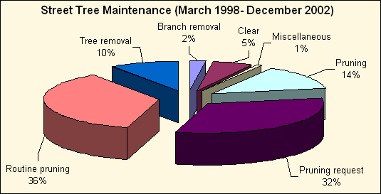 |
| Figure 18. Citywide street tree maintenance |
![]()
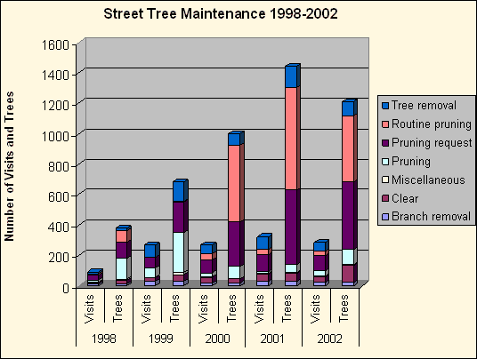 |
| Figure 19. Citywide street tree maintenance by year |
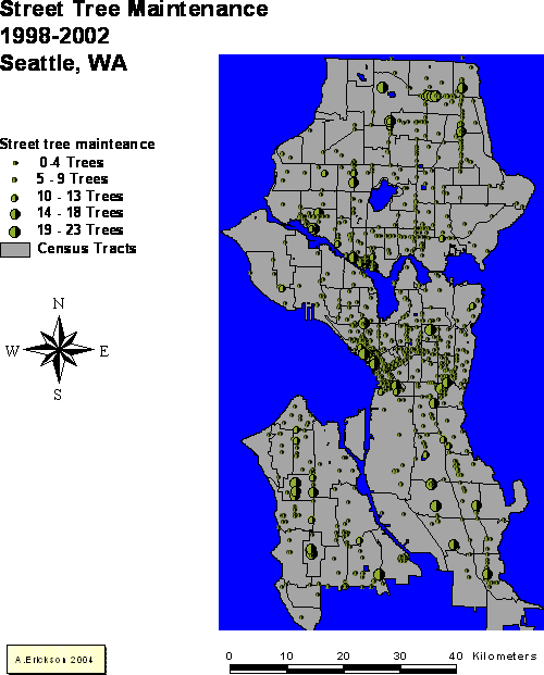 |
| Figure 20. Map of citywide street tree maintenance |
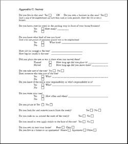 |
| Figure 20. Map of citywide street tree maintenance |
Appendix D: Pamphlet
|
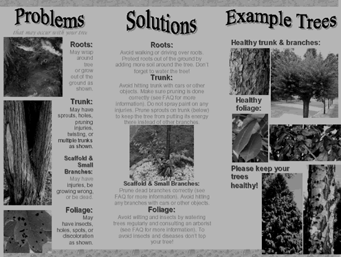 |