 |
 |
 |
 |


Development and Application of a Decision
Support Tool to Analyze Alternatives for Landscapes Composed of Multiple
Ownerships
|
by: Jeffrey Michael Comnick
Program Authorized to Offer Degree:
|
|||||||||||||||||||||||||||||||||||||||||||||||||||||||||||||||||||||||||||||||||||||||||||||||||||||||||||||||||||||||||||||||||||||||||||||||||||||||||||||||||||||||||||||||||||||||||||||||||||||||||||||||||||||||||||||||||||||||||||||||||||||||||||||||||||||||||||||||||||||||||||||||||||||||||||||||||||||||||||||||||||||||||||||||||||||||||||||||||||||||||||||||||||||||||||||||||||||||||||||||||||||||||||||||||||||||||||||||||||||||||||||||||||||||||||||||||||||||||||||||||||||||||||||||||||||||||||||||||||||||||||||||||||||||||||||||||||||||||||||||||||||||||||||||||||||||||||||||||||||||||||||||||||||||||||||||||||||||||||||||||||||||||||||||||||||||||||||||||||||||||||||||||||||||||||||||||||||||||||||||||||||||||||||||||||||||||||||||||||||||||||||||||||||||||||||||||||||||||||||||||||||||||||||||||||||||||||||||||||||||||||||||||||||||||||||||||||||||||||||||||||||||||||||||||||||||||||||||||||||||||||||||||||||||||||||||||||||||||||||||||||||||||||||||||||||||||||||||||||||||
| Figure 1 | Toggle main page |
| Figure 2 | Toggle input table for one silvicultural pathway |
| Figure 3 | Toggle input page for silvicultural pathway data for group one |
| Figure 4 | Toggle group acreage input page |
| Figure 5 | Toggle maximum value input page |
| Figure 6 | Toggle threshold values page |
| Figure 7 | Toggle output page |
| Figure 8 | Toggle output page before and after area allocation |
| Figure 9 | Toggle matrix page |
| Figure 10 | Location of study area in Oregon state |
| Figure 11 | Ownership pattern within study area |
| Figure 12 | Multiple-Toggle program |
| Figure 13 | Total Harvest Volume |
| Figure 14 | Normalized values for each objective for all alternatives |
| Figure 15 | Summary values over time for each objective and BLM alternatives |
| Figure 16 | Summary values over time for each objective and private alternatives |
| Figure 17 | Summary values over time for each objective and landscape alternatives |
| Figure 18 | Stand structure graph for BLM No Action alternative |
| Figure 19 | Target density graph for BLM No Action alternative |
| Figure 20 | Spotted owl habitat graph for BLM No Action alternative |
| Figure 21 | Stand structure graph for BLM Alternative E |
| Figure 22 | Harvest volume graph for BLM Alternative E |
| Figure 23 | Spotted owl habitat graph for BLM Alternative E |
| Figure 24 | Stand structure graph for Landscape Alternative 2 |
| Figure 25 | Stand structure graph for Private Alternative 2 |
| Figure 26 | Harvest volume graph for Private Alternative 2 |
| Figure 27 | Spotted owl habitat graph for Landscape Alternative 2 |
| Figure 28 | Stand structure graph for Landscape Alternative 3 |
| Figure 29 | Harvest volume graph for Landscape Alternative 3 |
| Figure 30 | Target density graph for Landscape Alternative 3 |
| Figure 31 | Spotted owl habitat graph for Landscape Alternative 3 |
| Figure 32 | Private stand structure graph after first change to Pvt. Alt. 2 |
| Figure 33 | Landscape Harvest Volume graph after first change to Pvt. Alt. 2 |
| Figure 34 | Private stand structure graph after second change to Pvt. Alt. 2 |
| Figure 35 | Landscape Harvest Volume graph after second change to Pvt. Alt. 2 |
![]()
Introduction
Forest management has evolved through the 20th Century
from focusing on commodity production on a stand-by-stand basis
to meeting many objectives, including sustaining ecosystem structures,
functions and processes. The new paradigm, ecosystem management
or landscape management, broadens the scope of planning and analysis
spatially and temporally. Common analysis units now include watersheds
and landscapes in addition to individual stands.
Despite a range of interpretations, ecosystem management typically
requires consideration of a wider range of social and environmental
objectives and greater understanding and application of ecological
and silvicultural knowledge than previously. Decision support has
been identified as a critical component to ensure values, available
information, and current scientific knowledge are included in the
ecosystem management decision-making process (Oliver and Twery,
1999). Existing and new technologies are necessary to facilitate
analysis and provide decision support for landscape planning. These
technologies include computer applications such as geographic information
systems (GIS) and the Landscape Management System (LMS) (McCarter
et al., 1998).
A difficulty of planning at the landscape or watershed scale is
that frequently the area is divided among multiple ownerships. Sample
(1992) stated that:
There are few areas of the U.S. in which the delineation of these ecosystems at an ecologically-significant scale does not encompass a mixture of both public and private lands, often in an intermingled pattern inconsistent with ecological boundaries. This suggests the need for a higher level of coordination and cooperation among adjacent public and private landowners in the planning and management of forest and range lands for the protection of biological diversity, water quality, and other ecosystem values.
This study will demonstrate the use of GIS, LMS, and a prototype
decision support tool named Toggle for development and analysis
of a management plan by one owner in context of estimated management
activities by a neighboring owner. Multiple objectives will be analyzed
at both the single-ownership level and the multiple-ownership level.
The Toggle program will be demonstrated in the context of decision
support for landscape management and for use in the rational-iterative
decision making process. Results for the study site, a landscape
in Oregon comprised of United States Department of Interior Bureau
of Land Management (BLM) and private industry lands, will also be
discussed.
Literature Review
Spatial and Temporal Complexity in Forest Ecosystems
Developing and implementing management plans for a forested area
is difficult because of the complexity of the natural world. This
complexity is defined with the concept of the ecosystem. Tansley
first used the term in 1935, including both organisms and the surrounding
physical factors (Tansley, 1935). Odum later defined the ecosystem
as "any unit that includes all of the organisms (i.e. the "community")
in a given area interacting with the physical environment so that
a flow of energy leads to clearly defined trophic structure, biotic
diversity, and material cycles (i.e. exhange of materials between
living and nonliving parts) within the system (Odum, 1971).
The ecosystem concept indicates a systems approach to dealing with
the complex natural world. This approach reduces complexity by grouping
common entities and dealing with the interactions between groups
(Oliver et al., 1992). It also allows the ecosystem to be delineated
in many ways by organizing groups differently (Kimmins, 1987). Tansley
and Odum implied this variability by not indicating a specific spatial
scale in their definitions. Later definitions explicitly identified
the hierarchical nature of ecosystems (O'Neill et al., 1986). The
appropriate delineation depends on the issue being addressed and
can include an individual organism, a landscape, or a larger region.
Complexity is further increased by the temporal dimension of forest
ecosystems. Trees and other vegetation grow through time, and stands
and landscapes experience competition related mortality and other
small and large scale disturbances. These include fire, wind, insects,
and disease. Oliver and Larson (1996) identified four stand development
stages: stand initiation (open), stem exclusion (dense), understory
reinitiation, and old growth (complex).
The open stage exists from the time of a stand replacing disturbance,
during regeneration, until further regeneration is excluded by competition
from established trees. Stem exclusion then occurs while trees grow
and compete, until competition related mortality and other disturbances
create openings in the previously dense main canopy. Increased growing
space allows trees, shrubs and other herbaceous plants in the understory
to become established during the understory reinitiation stage.
Finally, large overstory trees die and multiple canopy layers develop
during the old growth stage, creating an uneven-aged structure (Oliver
and Larson, 1996).
The names for these processes also apply to corresponding stand
structures, which are the physical arrangement of trees and other
vegetation. At any point in time, a forest and landscape are comprised
of various amounts of one or several stand structures. These proportions
vary through time (Oliver, 1992).
![]()
Ecosystem Management in a Single Ownership
A common objective of ecosystem management is maintaining ecosystem
functions and processes (Vogt et al., 1997). This can include maintaining
biodiversity and forest health, such as maintaining stands resistant
to local disturbance agents (fire, wind, insects, and disease).
Other management objectives include optimizing harvest volume, revenue,
recreation, aesthetics, and many more.
Many ecosystem processes and functions occur at broad spatial scales.
Examples include biodiversity and the home range of some species
(Oliver et al., 1992). Common planning units in forest management
now include landscapes and watersheds. The watershed has been identified
as a necessary planning level by the Federal Ecosystem Management
Assessment Team (FEMAT) and the Washington State Department of Natural
Resources (Sessions et al., 1997).
To achieve the various objectives, a landscape approach has been
proposed that maintains a mix of all stand structures across the
landscape at all times (Oliver, 1992; Hunter, 1990). This approach
utilizes systems theory by identifying five hierarchical management
levels, determining appropriate objectives to be achieved at each
level, and coordinating activities between each level. The five
levels of forest management, from the most "specific"
to the most diffuse, are: silvicultural operations, silvicultural
regimes (silvicultural pathways), landscape patterns, forest plans,
and broader policy (Oliver et al., 1999). Salwasser (1991) identified
the necessity to conduct ecosystem management on similar scales
(Stand/Site, Watershed, Landscape, and Region), and similar corresponding
management levels (Project, District, Forest, Regional, and National/Congressional)
have been identified in the Forest Service (Carwse, 1994 as cited
in Hobbs, 1998).
Silvicultural operations are the most specific level. These include
harvesting and planting trees, pruning, fertilizing, road construction,
and others. Decisions requiring the most site specific information
must be made at this level. For some objectives, operations can
be designed to mimic natural disturbances.
Silvicultural regimes are the stand level treatments applied through
time to achieve desired objectives, including future stand characteristics.
Each stand structure provides a unique set of values, including
habitats, aesthetics, recreation, and resistance to various disturbance
agents (Oliver et al., 1992). Knowledge of stand dynamics is important
to understand how trees and other vegetation will respond to treatments
in order to achieve desired future conditions. "Windows",
or periods of time when stands respond effectively to treatments,
should be identified for each stand (Oliver and Larson, 1996). These
windows of opportunity exist for many operations, including planting
and thinning (Oliver et al., 1999).
The landscape level coordinates silvicultural treatments to all
stands at all times to ensure a desired mix of stand structures.
Through a "coarse filter" approach, managing at this level
ensures habitat will be provided for most species, since most habitats
can be associated with one or more stand structures (Oliver, 1992).
Spatial arrangement of structures may also be important for reasons
such as habitat, corridors, and operation implementation. Planning
at the landscape level can ensure that objectives with spatial criteria
are achieved and spatially feasible plans are developed (Oliver
et al., 1999).
The next hierarchical level, the forest, manages the flows of outputs
from various landscapes. It is not concerned with spatial feasibility.
This level coordinates landscapes and utilizes economies of scale
to manage implementation costs and marketing of commodity products
and other outputs (Oliver et al., 1999).
Finally, the policy level coordinates the flow of values within
a uniform political unit. This can include companies or state and
federal governments. Instruments at this level include incentives
and regulations. Incentives can be tax reductions, market incentives,
education, research, and monetary grants. Regulations can be laws
and other procedural rules (Lippke and Oliver, 1993).
Through coordination between the hierarchical levels, management
objectives are achieved. Coordination can include analysis, decision-making,
and implementation; and information can move from the specific level
to the diffuse level as well as from diffuse to specific. For example,
final selection of a chosen management plan to implement occurs
at more diffuse levels; however, implementation and the effects
of implementation occur first at the specific level. Identifying
the appropriate level at which to manage for a particular task is
important to ensure efficient management of the system (Oliver et
al., 1999).
![]()
The systems approach reduces ecosystem complexity and improves
management for desired objectives. Additional problems with managing
ecosystems include the variability in the spatial and temporal dimensions
of ecosystem boundaries and the related variability of associated
management objectives defined by those boundaries. Societal weights
or values associated with those objectives can also be difficult
to determine (Oliver and Twery, 1999). An appropriate decision-making
process must be utilized which incorporates this degree of uncertainty.
A variety of decision-making processes exist. The Expert/Intuitive
method relies on the judgment of an expert or group of experts,
and can result in "groupthink" and decisions based on
charisma. The "Muddling Through" approach addresses needs
on a case-by-case basis to reduce present conflicts without extensive
analysis of values and consequences. With the crisis approach, a
manager assumes broader authority than needed to avert a perceived
impending catastrophe. The Normative/Rational non-iterative approach
is appropriate when all objectives, weights, and interactions between
modules are known or uncertainty can be quantified. This approach
allows optimization to determine the best solution. Finally, the
Normative/Rational iterative method is appropriate when objectives
and weights are not well understood, but interactions between modules
or uncertainty can be predicted (Oliver and Twery, 1999).
The rational-iterative decision-making process is the most appropriate
for ecosystem management. Through this process, multiple alternatives
are presented, and alternatives can be refined by working "iteratively"
with the decision-maker. This approach allows decision-makers to
understand trade-offs and select a chosen alternative through iteration.
The steps of the rational-iterative decision-making process are:
1) Identify the decision-makers,
2) Identify the problem, define the objectives, and develop measurable criteria,
3) Develop alternatives,
4) Compare alternatives,
5) Choose an alternative,
6) Implement the chosen alternative,
7) Monitor and evaluate.
The person with authority to make a decision must be identified
first. Although many stakeholders may have a very high interest
in the selection of a particular alternative, the person with legal
authority or jurisdiction must be specified. Next, the problem must
be defined, and objectives determined. This step includes scoping
the planning area to determine initial conditions, identifying objectives,
and converting objectives to measurable criteria. Scoping the planning
area is necessary to identify the appropriate spatial scale and
to examine initial landscape conditions to determine if perceived
problems actually exist (Oliver and Twery, 1999). Management objectives
must then be identified and converted to measurable criteria. Measurable
criteria convert vague objectives to specific conditions defined
numerically to indicate the degree of success each management alternative
has in meeting objectives. Measurable criteria in forest management
can frequently be defined by stand characteristics, such as number
of trees per acre of a given size or percent canopy closure to define
stand structures. The spatial and temporal dimensions of the analysis
must also be determined. This step may also include development
of models to describe vegetation growth, habitat for various species,
or models for many other objectives (Oliver and Twery, 1999).
Next, a range of management alternatives must be developed. This
is a creative step and can include many role-playing "games"
to avoid "groupthink." All interested stakeholders could
be allowed to develop an alternative, ensuring a wide range to analyze
and compare (Oliver and Twery, 1999). A useful baseline alternative
is no action, where the forest vegetation is allowed to grow through
time with no silvicultural operations.
Each alternative is then compared to each objective to determine
trade-offs. A decision matrix, which lists the impact of each alternative
on each objective in a single table, can be useful for the decision-maker.
Also, using normalized values, which lists results as a proportional
score to a maximum value, can ensure decision-makers are not biased
between objectives which commonly have large numbers, such as harvest
volume, and objectives which commonly have small numbers (Oliver
and Twery, 1999).
Next, the decision-maker must select a chosen alternative to implement.
Prior to selecting an alternative, an analyst may need to explain
the results, including assumptions embedded in models and measurable
criteria, to ensure the decision-maker makes an informed decision.
Because the process is iterative, the decision-maker may require
additional alternatives to be developed after considering the initial
set. The decision-maker selects an alternative based on the trade-offs
between objectives, and can ignore one or many objectives at this
point. Management objective weights and social values, previously
not accounted for during the rational-iterative process, are implied
with this step in the selection of a chosen alternative.
The remaining steps are implementation of the chosen alternative
and monitoring and evaluation. Implementation includes coordinating
the hierarchical management levels to ensure overall policy objectives
are achieved. Because planning and implementation are rarely perfect,
monitoring and evaluation must be conducted to determine when objectives
are not being achieved and why. In forest management, because implementation
of an alternative generally occurs over many years, early monitoring
can allow alternatives to be adjusted or implementation of later
activities to be improved (Oliver and Twery, 1999). Adjustments
may include improving models and measurable criteria, increasing
scientific understanding, and adjusting scientific and management
paradigms.
![]()
Analysis of ecosystems over broad spatial scales for many objectives
requires large amounts of data and many computations. Projecting
landscapes through time and analyzing each objective at periodic
increments increases the number of computations further. Advancements
in computing power and development of several computer applications
have been important in making landscape management practical. These
computer applications include geographic information systems (GIS)
and the Landscape Management System (LMS).
GIS is a commonly used forest management tool that displays and
analyzes spatially referenced information (Star and Estes, 1990).
In forestry, this information commonly includes location of stand
boundaries, streams, roads, and soils as well as many other features.
GIS is capable of performing spatial analyses required for ecosystem
management.
LMS is a Microsoft Windows® application that combines existing
growth models, including the Forest Vegetation Simulator (FVS),
visualization tools, and analysis tools to conduct analyses rapidly
for a landscape comprised of a number of forest stands (Stage, 1973).
The program organizes tree list inventories for each stand, stand
boundaries, and a digital elevation model. Landscapes are analyzed
as the aggregate of all stands. Silvicultural operations can be
modeled and applied to one or many stands, and treated inventories
projected through time. Tables can be produced which analyze any
treated and projected inventories (McCarter et al., 1998). Growth
models allow LMS to perform temporal analyses required for ecosystem
management.
An additional companion program for LMS is Toggle. Toggle is a Microsoft
Excel® spreadsheet program that allows users to conduct a multiple
objective, landscape level analysis for many time periods. Toggle
is a strata-based area allocation model, in which the user manually
adjusts the percentage of acres in each stratum (group) subject
to a particular silvicultural pathway. Each adjustment affects the
outputs provided for each objective. Graphs, summary values, and
normalized values for all objectives update immediately as percentages
are changed in the program. Groups are typically defined by common
significant ecological characteristics, such as dominant species,
stand density, and stand age. Silvicultural pathways for each group
are then modeled in LMS. Output tables which analyze objectives
are obtained from each group from LMS and are input into Toggle
for analysis. Toggle programs with the capacity for 6 groups and
15 pathways for each group have been used in studies by Johnson
(2001) and Hall (2001).
Analysis in Toggle is based on the concepts that any stand can follow
a range of silvicultural pathways leading to different stand structures;
each stand structure provides a unique set of outputs and values;
and achieving a desired mix of ecological, economic, and social
values can be attained by providing some mix of all stand structures
across the landscape. To provide a more detailed explanation of
the program, the most significant steps for using the spreadsheet
will be described. The Toggle spreadsheet organizes 58 separate
worksheets, with functions including input data storage, preliminary
and summary calculations, graphical and tabular output, storing
alternatives, and storing adjustable model values. Microsoft Visual
Basic for Applications® code is also used to add functionality.
A screen capture of the opening Toggle page is provided in Figure
1. From this sheet, most other Toggle functions can be accessed.
Modeling alternatives in Toggle begins with identifying groups and
representative stands for the landscape. For each group, a range
of silvicultural pathways are modeled in LMS. These pathways represent
different potential management options based on identical initial
conditions. Tables that report outputs for all objectives at each
point in time are obtained from LMS and pasted into Toggle. An example
of a portion of an input table is provided in Figure 2. Each silvicultural
pathway to be included in Toggle requires an input table. A screen
capture of the input page for one group is provided in Figure 3.
In addition to loading Toggle with tables from LMS, the total number
of acres in each group must also be inputted (Figure 4).
Certain aspects of Toggle can be adjusted by the user, including
threshold values and maximum values. Threshold values are components
of measurable criteria that indicate the point of success or failure
for achieving an objective. It may be necessary to adjust threshold
values depending on local conditions or the performance of a particular
growth model. For example, a landscape on more exposed aspects may
have a different wind safety threshold value (height/diameter ratio)
than a landscape on less exposed aspects. For Toggle to report accurate
normalized values, maximum values must also be determined and inputted.
Maximum values are necessary to scale current values for an objective
to calculate the proportional normalized value. Screen captures
for worksheets where threshold values and maximum values can be
adjusted are provided in Figure 5 and Figure 6, respectively.
Analysis can then be completed in Toggle. Beginning with group one,
the user allocates a percentage of the total group area to follow
each potential silvicultural pathway for that group, until 100%
of the area has been allocated. As area is allocated to a pathway,
output values, previously per acre values, are multiplied by the
number of committed acres to calculate total values. These calculations
are accomplished automatically by the spreadsheet and immediately
when the user adjusts any pathway percentages. The same process
of area allocation to silvicultural pathways is completed for each
group. To obtain output values for the entire landscape, the spreadsheet
sums the outputs for all pathways (after being multiplied by the
allocated acreage factor) for all groups. When the user has committed
100% of the area in all groups, the landscape alternative is complete.
Figure 7 shows the Toggle output page where percentages allocated
to silvicultural pathways can be controlled, and output values are
graphed. Figure 8 shows a portion of the output page before and
after acres are allocated to illustrate how graphs change immediately
in response to new output total values.
After an alternative is developed it can be stored in the program,
allowing the user to develop additional alternatives. The spreadsheet
stores pathway percentages for each group, and can automatically
reconstruct alternatives. Toggle also generates a decision matrix
of normalized values from each saved alternative. A screen capture
of the worksheet where alternatives can be saved is provided in
Figure 9.
![]()
Many other computer applications have been developed to facilitate forest management and ecosystem management. Two programs will be briefly discussed to provide context for LMS and Toggle. These are FORPLAN (Johnson et al., 1986) and SNAP (Sessions and Sessions, 1992). This should not be considered an extensive critique of the tools, or an in-depth comparison between any of the applications. FORPLAN is a forest level, strata-based decision support tool developed for the Forest Service which utilizes linear programming to optimize an objective under given constraints. Criticisms of FORPLAN include: it utilizes the rational non-iterative decision-making process, which is not considered appropriate where objectives and weights are not well known (Oliver and Twery, 1999); both the model and the outputs are extremely complex and difficult to understand (O'Toole, 1983); and model outputs fail to account for spatial criteria or cumulative effects and are thus difficult to implement successfully (Johnson, 1992). SNAP is a GIS based harvest scheduling model. This program can identify near-optimal solutions for location of harvest units based on spatial constraints such as adjacency ("green-up"), maximum opening sizes, minimum habitat levels, and road networks. SNAP is more limited in the spatial scale it can analyze. Also, neither FORPLAN nor SNAP maintains tree-level resolution for each stand, limiting the ability of these programs to analyze additional objectives as necessary.
Ecosystem Management Across Multiple Ownerships
A difficulty of practicing ecosystem management at broad spatial scales is that watersheds and landscapes are frequently divided among multiple ownerships or agencies. Many potential barriers exist for collaboration, including state and federal laws. Where successful collaboration has occurred, key components have been identified.
Examples of comanagement include the Shelton Cooperative Sustained
Yield Unit and the Plum Creek Habitat Conservation Plan. The Shelton
Cooperative Sustained Yield Unit (CSYU) was formed in 1946 through
an agreement between Simpson Timber Company and the Forest Service.
The CSYU is on the Olympic Peninsula of Washington State. The CSYU
was intended to be comanaged for sustained yield timber volume to
stabilize the local communities of Shelton and McCleary and to ensure
the general forest health of the contiguous area (U.S.D.A. Forest
Service, 1946).
The Plum Creek Cascades Habitat Conservation Plan (HCP) was developed
in 1996 for company land in the central Cascade Mountains in Washington
State. The planning area was of the "checkerboard" configuration,
with alternating sections of Plum Creek ownership and National Forest.
Although the HCP did not establish a cooperative agreement, consideration
of the contiguous landscape, rather than only the fragmented company
land, was critical for successful application for an incidental
take permit (Plum Creek, 1996). An incidental take permit allows
a company to conduct operations in areas with endangered species
without penalty for incidentally harming or killing an individual
of the species. This consideration included assumptions of the activities
that would occur on federal land during the 50-year plan, resulting
forest conditions, and cumulative impacts when analyzed with projected
Plum Creek activities (Plum Creek, 1996).
Finally, an analogous cooperative situation outside forestry may
be the Clean Air Act of 1990, where many industries in an area must
coordinate to reduce pollution below a certain level. This cooperation
includes market functions, such as the selling of excess pollution
quotas by companies efficient at pollution reduction to companies
which are inefficient (Bryner, 1995). It also includes regulations,
in the form of the collective pollution limit.
Legal barriers to comanagement include the Federal Advisory Committee
Act (FACA) and the Sherman Anti-Trust Act. FACA requires any advisory
committee formed by the federal government that includes individuals
who are not federal, state, tribal, or local officials to include
a balanced membership in terms of points of view represented. Comanagement
on landscapes with federal and private land will be subject to FACA.
This may result in inappropriate federal control and bureaucratic
delay and cost (Meidinger, 1997). Between private companies, the
Sherman Anti-Trust Act prohibits cooperation or exchange of information
that would result in any form of price fixing (Meidinger, 1997).
Other laws can indirectly influence comanagement as well. Many private
landowners may not want to improve wildlife habitat for fear an
endangered species would inhabit the ownership. The Endangered Species
Act could then severely limit potential activities (Sample, 1995).
Many landowners are also hesitant to enter into a comanagement agreement
because flexibility in future decision-making may be limited (Sample,
1995). For example, inheritance taxes may eventually require a landowner
to harvest timber without regard to ecological values or the effect
to a comanaged landscape (Sample, 1995).
Overcoming these laws to conduct comanagement may require clarification
of certain points specific to natural resource management. For example,
concerning the Sherman Anti-Trust Act, cooperating companies may
be prohibited from sharing harvest volume information, but instead
could share stand structures and agree to manage for a desired mix.
Other laws, such as the Endangered Species Act, may require reauthorization
to ensure a consistent national policy for forest ecosystem management
(Sample, 1995). Finally, new legal mechanisms also exist which encourage
collaboration for ecosystem management, such as conservation easements
(Meidinger, 1997). These legal issues are important but beyond the
scope of this paper.
![]()
Disregarding legal deterrents and other disincentives, several
important criteria have been identified in successful partnerships.
These include need, presence of a catalyst organization, peer-to-peer
networking, communication, and trust (Sample, 1995). Because comanagement
requires additional effort, a perceived need is critical for successful
partnership. Even with a need, Sample (1995) identified a catalyst
organization as the most important element for success. The topics
covered in this study, including application of specific computer
programs within an appropriate decision support system framework,
are a component of communication. Sample (1995) also identified
that communication includes sharing of experiential, historical,
and cultural knowledge as well as technical knowledge.
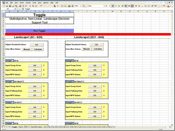
Figure 1. Toggle main page. When the Toggle spreadsheet is opened, this is the active page. From this page, most program functions can be accessed, including silvicultural pathway data input, group acreage input, maximum value data input, adjusting threshold values, and performing the analysis.
|
Year
|
Stand
|
Acres
|
InitAge
|
Oliver5c
|
HCSSPT
|
Carey
|
StandingVol
|
CutVol
|
VolGrowth
|
DomSPP
|
H/D(100)
|
HT(100)
|
TPA
|
|
|
2002
|
DF10
|
1
|
10
|
1_SI
|
1_SI
|
1_SI
|
0
|
0
|
0
|
DF
|
86.55
|
24.1
|
448.2
|
. |
|
2007
|
DF10
|
1
|
10
|
2_SE
|
2_SE
|
1_SI
|
871.75
|
0
|
871.75
|
DF
|
59.85
|
36.48
|
445.54
|
. |
|
2012
|
DF10
|
1
|
10
|
2_SE
|
2_SE
|
2_ES
|
12812.29
|
0
|
11940.54
|
DF
|
56.77
|
47.17
|
436.09
|
. |
|
2017
|
DF10
|
1
|
10
|
2_SE
|
2_SE
|
2_ES
|
25802.36
|
0
|
12990.07
|
DF
|
56.65
|
57.51
|
417.42
|
. |
|
2022
|
DF10
|
1
|
10
|
2_SE
|
3_UR
|
2_ES
|
34497.61
|
0
|
8695.25
|
DF
|
58.72
|
66.96
|
393.08
|
. |
|
2027
|
DF10
|
1
|
10
|
2_SE
|
2_SE
|
2_ES
|
41518.4
|
0
|
7020.79
|
DF
|
60.44
|
76.4
|
365.63
|
. |
|
2032
|
DF10
|
1
|
10
|
2_SE
|
2_SE
|
2_ES
|
50274.54
|
0
|
8756.14
|
DF
|
61.8
|
85.18
|
338.18
|
. |
|
2037
|
DF10
|
1
|
10
|
2_SE
|
2_SE
|
2_ES
|
58413.26
|
0
|
8138.72
|
DF
|
63.19
|
93.4
|
312.05
|
. |
|
2042
|
DF10
|
1
|
10
|
2_SE
|
2_SE
|
2_ES
|
66160.01
|
0
|
7746.75
|
DF
|
64.74
|
101.29
|
287.75
|
. |
|
2047
|
DF10
|
1
|
10
|
2_SE
|
2_SE
|
3_UR
|
71982.6
|
0
|
5822.59
|
DF
|
65.96
|
108.36
|
265.7
|
. |
|
2052
|
DF10
|
1
|
10
|
3_UR
|
2_SE
|
3_UR
|
76381.88
|
0
|
4399.28
|
DF
|
67.2
|
115.56
|
245.9
|
. |
|
2057
|
DF10
|
1
|
10
|
3_UR
|
2_SE
|
3_UR
|
83032.71
|
0
|
6650.83
|
DF
|
68.25
|
121.98
|
227.9
|
. |
|
2062
|
DF10
|
1
|
10
|
3_UR
|
2_SE
|
3_UR
|
87539.09
|
0
|
4506.38
|
DF
|
69.52
|
128.33
|
212.15
|
. |
|
2067
|
DF10
|
1
|
10
|
3_UR
|
2_SE
|
3_UR
|
94722.39
|
0
|
7183.3
|
DF
|
70.94
|
134.44
|
197.75
|
. |
|
2072
|
DF10
|
1
|
10
|
3_UR
|
2_SE
|
3_UR
|
97672.01
|
0
|
2949.62
|
DF
|
71.86
|
139.65
|
184.95
|
. |
|
2077
|
DF10
|
1
|
10
|
3_UR
|
2_SE
|
3_UR
|
103307.87
|
0
|
5635.86
|
DF
|
72.93
|
144.7
|
173.66
|
. |
|
2082
|
DF10
|
1
|
10
|
3_UR
|
2_SE
|
5_BD
|
107612.68
|
0
|
4304.81
|
DF
|
73.81
|
149.03
|
163.31
|
. |
|
2087
|
DF10
|
1
|
10
|
3_UR
|
2_SE
|
5_BD
|
113171.42
|
0
|
5558.74
|
DF
|
74.38
|
152.4
|
153.86
|
. |
|
2092
|
DF10
|
1
|
10
|
3_UR
|
2_SE
|
5_BD
|
118059.22
|
0
|
4887.8
|
DF
|
74.94
|
155.48
|
145.31
|
. |
|
2097
|
DF10
|
1
|
10
|
3_UR
|
2_SE
|
5_BD
|
120547.77
|
0
|
2488.55
|
DF
|
75.37
|
158.28
|
137.66
|
. |
Figure 2. Toggle input table for one silvicultural pathway. Values are provided for all objectives every projection cycle. Outputs are based on calculations performed on standing and cut inventories by LMS. Output values include stand structure, standing, harvest, and growth volumes, species mix, height/diameter ratio, average stand height, trees per acre, harvest volume by species, basal area by species, and others.
![]()
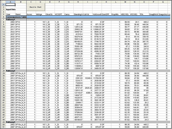
Figure 3. Toggle input page for silvicultural pathway data for group one. One input table (see Figure 2) is pasted into the appropriate cells on the page for each silvicultural pathway modeled for the current group. A similar page exists for each group to store pathway input data.
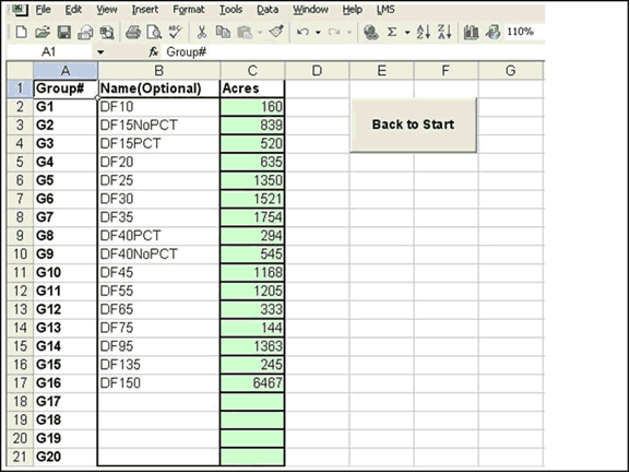
Figure 4. Toggle group acreage input page. The total number of acres in each group must be entered. Analysis in Toggle is based on allocating percentages of groups to silvicultural pathways. These percentages are multiplied by the total acres in that group to calculate the actual number of acres committed to that pathway. All per acre input values can then be multiplied by the number of committed acres to calculate total output values.
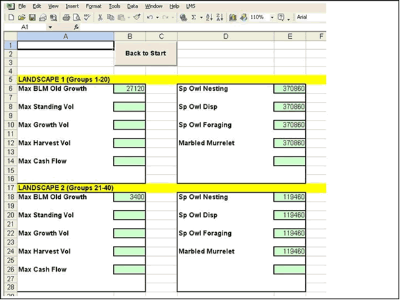
Figure 5. Toggle maximum value input page. Maximum values must be input to calculate accurate normalized values. Maximum values can be input for complex structure (acres), standing, growth, and harvest volume (mbf), cash flow (dollars), spotted owl nesting, foraging, and dispersal habitat (acres), and marbled murrelet habitat (acres). Normalized values are calculated by dividing the current value for an objective by the maximum value to determine the proportional score.
Figure 6. Toggle threshold values page. Threshold values for many objectives can be adjusted in Toggle. Threshold values indicate the point of success or failure for an objective. Adjusting these values may be necessary to calibrate the model for local conditions or performance by a particular growth model variant. A sensitivity analysis can also be performed by altering threshold values slightly and restoring a previously modeled alternative to determine the degree of change for Toggle results.
![]()
Figure 7. Toggle output page. From this page, the user can allocate group acres to silvicultural pathways, and graphs update immediately to display the new mix of outputs. Each graph is displaying output units (acres or MBF) over time (years). Larger versions of these graphs can be examined in later figures. The list of the silvicultural pathways appear in column A, with the corresponding percentage in column B. Each group utilizes the same space, with only one group active at a time. By clicking on the 'Back' and 'Next' buttons on this page, other groups can be selected as the active group and toggled.
Figure 8. Toggle output page before and after area allocation. This figure demonstrates how outputs change when area is allocated to silvicultural pathways and how alternatives are developed. The top screen capture shows all pathways for all groups set to 0%. The bottom screen capture shows 5% of group 1 allocated to pathway 2. The output graphs for stand structure (left) and harvest volume (right) change immediately. Larger versions of these graphs can be examined in later figures. All graphs not shown also change. As the user allocates more area to this pathway or other pathways, the graphs change in response to the new set of output values.
Figure 9. Toggle matrix page. On this page, alternatives can be saved or restored. Saving alternatives saves the percentages allocated to all silvicultural pathways for all groups, and copies the normalized values for all objectives into a decision matrix containing the normalized values for all other saved alternatives. When an alternative is restored the spreadsheet automatically reallocates the percentages to the appropriate pathways for each group, and outputs are graphed as before.
![]()
Methods
Study Area Description
The study area is located in western Oregon, approximately 20 miles southwest of the city of Eugene in Lane County (Figure 10). Most of the study area is located in the Upper Siuslaw watershed, a 5th field drainage. The ownership pattern is of the "checkerboard" configuration, with alternating sections of primarily BLM and private industry ownership (Figure 11). The study area is located in the Coast Ranges physiographic province (Franklin and Dyrness, 1973).
The Coast Ranges province contains often steep mountain slopes with ridges because of streams and west-flowing rivers (Franklin and Dyrness, 1973). The study area is generally defined by the drainage for the west running Siuslaw River, which runs through the site. Many streams on both the north and south facing slopes run into the river. Site quality within the study area ranges from a high site class 3 to a low site class 2 (DeMoss, June 10, 2002). The region is characterized by a wet, maritime climate (Franklin and Dyrness, 1973). The Upper Siuslaw watershed occurs in the Tsuga heterophylla vegetational area, with common species including Douglas-fir (Pseudotsuga menziesii), western hemlock (Tsuga heterophylla), and western red cedar (Thuja plicata). More specific vegetational characteristics will be discussed in the Methods section.
Management activities on BLM land are subject to many federal laws.
The most significant of these are the Federal Land Policy Management
Act (FLPMA), the National Environmental Policy Act (NEPA), and the
Northwest Forest Plan. The FLPMA was enacted in 1976, and requires
the BLM to manage its land for multiple-use to best meet the needs
of present and future generations (U.S.D.I. Bureau of Land Management,
2001). NEPA, enacted in 1969, requires the preparation of an Environmental
Impact Statement for any proposed management action that will impact
the natural environment (Bass and Herson, 1993). NEPA also encourages
ecosystem management by requiring federal agencies to use a systematic,
interdisciplinary approach to decision-making (Black and Herrington,
1974).
The Northwest Forest Plan was enacted in 1993. It was developed
from the work of the Forest Ecosystem Management Assessment Team
(FEMAT), which analyzed the viability of species associated with
old growth forests, particularly the northern spotted owl (FEMAT,
1993). This law allocated all federal land within the range of the
spotted owl into one of seven designations. These are Congressionally
Reserved Areas, Administratively Withdrawn Areas, Late-Successional
Reserves (LSR), Riparian Reserves, Adaptive Management Areas, Managed
Late-Successional Areas, and Matrix lands. Generally, Congressionally
Reserved Areas and Administratively Withdrawn Areas are permanent
reserves. Adaptive Management Areas are designed to test a landscape
management approach providing social, economic, and ecological values.
Late-Successional Reserves and Managed Late-Successional Areas allow
some silvicultural activities to produce and maintain forests with
complex structures. The remaining land is designated as Matrix,
and allows more typical forest management activities, including
thinnings and harvesting for timber production (Tuchmann et al.,
1996). The BLM land comprising the study area is in the LSR category.
The private land is owned by several industrial timber companies.
Management on these lands is subject to laws including the Endangered
Species Act, the Oregon State Forest Practices Act (State of Oregon,
1998), and company policy. These lands are managed for commodity
production primarily through intensive silviculture.
![]()
Modification of the Toggle Program
To complete the multiple ownership and cumulative effects analysis,
the Toggle tool was modified and functionality was expanded. Generally,
flexibility was increased in all existing aspects of the model,
and organization of the calculations and spreadsheets was improved
to allow construction of a larger model with a smaller file size.
An additional component was also added to sum outputs from individual
Toggle programs and display aggregate results for each objective
as graphs, summary values, and normalized values.
Existing functionality expansions included increasing the number
of groups and pathways to allow development of a more complex model.
Potential groups were increased from six to 20. Potential pathways
were increased from 15 to 50.
More significant for this study, the Toggle program was redesigned
to display outputs at multiple levels (i.e., single ownership and
multiple ownerships) simultaneously. Within each Excel Toggle workbook,
two 20 group landscapes can be modeled, each with unique representative
stands, objectives, and silvicultural pathways. Outputs for common
objectives were displayed at the cumulative level as well by summing
the outputs for the individual landscapes. Further, a new Excel
workbook was designed to sum the total outputs from two separate
Toggle programs. Although adjusting group percentages allocated
to silvicultural pathways can only be done at the individual Toggle
level, outputs at all levels change immediately. A screen capture
of this system is provided in Figure 12. This linked Toggle system
can model four unique landscapes with objectives tracked at three
distinct levels.
A significant improvement over the previous Toggle program was the
improved organization, allowing many more groups and pathways while
maintaining a very similar file size. This modification makes operating
several Toggle programs at the same time more reasonable on computers
with average hardware. Because of the flexibility of Excel and the
improved organization of Toggle, the system could be expanded rapidly
to allow more landscapes, more levels, or both. For example, for
two neighboring ownerships each with riparian and upland zones,
outputs could be reported first for both riparian and upland zones,
then aggregated and reported at the ownership level, then further
aggregated and reported and the multiple ownership level.
The increased flexibility and size of Toggle required certain calibration
steps to be improved as well. These included determining maximum
values and setting threshold values. To display outputs as normalized
values at each level, maximum values had to be determined at each
level. Flexibility was added to allow the program to calculate maximum
values automatically based on the inputs from pathways for each
group, or to allow the user to input the values manually. The previously
laborious step (Johnson, 2001) of manually determining which pathway
provided the most of a particular objective for each group, then
setting 100% of that group to that pathway to calculate a maximum
value was automated, a necessity with 20 potential groups and 50
potential pathways. Maximum values at aggregate levels were calculated
as the sum of corresponding maximum values for individual landscapes.
Finally, the functionality of the threshold values was expanded.
Threshold values are components of measurable criteria that indicate
the point of success or failure. The newly designed Toggle allowed
more measurable criteria to be adjusted through threshold values
in Toggle rather than LMS. Also, the Toggle allowed each landscape
and each level of output to be measured with a unique set of threshold
values.
![]()
Modeling the Study Area in Toggle
Several major steps were required to model alternatives for the entire landscape and for just the BLM portion in Toggle. Each step will be discussed in detail, including differences required between the BLM and the private lands. The steps completed can be identified as a subset of the rational-iterative decision making process, and will be presented in the corresponding order. The first step of the rational-iterative decision making process, identifying roles, will be assumed completed. Potential roles include a decision-maker (BLM personnel), analysts (the author and BLM personnel), and stakeholders (BLM, neighboring private lands, and other interested parties). The final steps (steps 5-7) of the process, including selecting a chosen alternative, implementation, and monitoring and feedback, will be considered beyond the scope of this paper.
For this project, scoping the study area for the BLM included grouping stands with similar tree and stand characteristics, identifying the number of acres in each group, and identifying a representative stand for each group. Stands used to complete the scoping process were forest operations inventory polygons within the LSR and associated tree lists where they existed. More frequently, where tree list information did not exist, stand history information was used. This information included year of establishment for the current stand, planting density, and date and description of subsequent silvicultural treatments up to the present time. Specific stand characteristics used to identify groups were age, density, and species. Using these criteria, the BLM land was divided into 16 groups:
1) DF10: Pure Douglas-fir, average age 10 years, 447 TPA
2) DF15NoPCT: Douglas-fir dominated, average age 15 years, 455 TPA
3) DF15PCT: Pure Douglas-fir, average age 15 years, 219 TPA
4) DF20: Douglas-fir dominated, average age 20 years, 158 TPA
5) DF25: Douglas-fir dominated, average age 25 years, 223 TPA
6) DF30: Douglas-fir dominated, average age 30 years, 244 TPA
7) DF35: Douglas-fir dominated, average age 35 years, 266 TPA
8) DF40: Douglas-fir dominated, average age 40 years, 386 TPA
9) DF45NoPCT: Douglas-fir dominated, average age 40 years, 259 TPA
10) DF45PCT: Douglas-fir dominated, average age 45 years, 242 TPA
11) DF55: Pure Douglas-fir, average age 55 years, 219 TPA
12) DF65: Pure Douglas-fir, average age 65 years, 290 TPA
13) DF75: Pure Douglas-fir, average age 75 years, 248 TPA
14) DF95: Pure Douglas-fir, average age 90 years, 90 TPA
15) DF135: Douglas-fir dominated, average age 135 years, 102 TPA
16) DF150: Douglas-fir, western hemlock, big leaf maple mixed, greater than 150 years, 39 TPA
After the groups were identified, a tree list for each representative
stand was generated. For the DF95, DF135, and DF150 groups, an average
tree list was created from existing stand inventories. These tree
lists were created to have representative distributions for species,
diameters, heights, and crown ratios. For the 13 groups with younger
stands, a representative tree list was generated by modeling the
silvicultural history from the point of establishment of the current
stand in LMS. The West Cascades variant of the FVS growth model
was used, with five year growth intervals (Stage, 1973). A keyfile
was applied to calibrate the model to induce density related mortality
at lower densities. The keyfile is provided in Appendix B. The expert
opinion of the local BLM forester was used to validate that the
tree lists were reasonable representative inventories (DeMoss, January
31, 2002).
Inventory data for the private land was not readily available. To
approximate the coverage types, two sources were used. First, broad
classification types were determined from the Coastal Landscape
Analysis and Modeling Study (CLAMS) (Ohmann and Gregory, 1996).
Classifications which composed less than 10% of the total acres
were grouped with similar types to produce six significant coverages.
The private land was divided into the following groups:
1) Broadleaf: Red alder dominated, average DBH 10.3 inches, 202 TPA
2) Mixed: Douglas-fir, hardwood mixed, average DBH 12.4 inches, 227 TPA
3) Open Forest: Pure Douglas-fir, average DBH 1.1 inches, 350 TPA
4) Small Conifer: Pure Douglas-fir, average DBH 3.5 inches, 347 TPA
5) Medium Conifer: Pure Douglas-fir, average DBH 14.6 inches, 269 TPA
6) Large Conifer: Douglas-fir, western hemlock, western red cedar, big leaf maple mixed, average
DBH 22.8 inches, 43 TPA
Second, with input from the local field forester, typical silvicultural
pathways were estimated for the surrounding private industry (DeMoss,
March 28, 2002). Using the same modeling technique utilized for
the BLM data, the estimated stand type silvicultural histories were
modeled in LMS to produce current tree list inventories for the
private land.
With the completion of the scoping step, an LMS portfolio was created
for the BLM with 16 representative stands, and for the private land
with six representative stands. The number of acres in each group
is provided in Appendix B. In LMS, however, each representative
stand was modeled as a single acre. The stands were also given average
slope, aspect, and elevation values for that portion of the middle
Siuslaw watershed for use by the FVS growth model (DeMoss, January
31, 2002).
![]()
Simultaneously with the development of the data set used to model
the LSR, objectives were identified and measurable criteria were
defined to assess their fulfillment. A large set of objectives and
measurable criteria were identified by the BLM Eugene District LSR
interdisciplinary (ID) team. Some objectives, such as development
of complex forest structure and amount of spotted owl nesting, foraging,
and dispersal habitat, had been identified as the primary objectives
when the LSR was established by the Northwest Forest Plan (Tuchmann
et al., 1996). A subset of the larger set was selected for this
study. The objectives chosen were coarse filter biodiversity, total
harvest volume, stand density, and spotted owl nesting, foraging,
and dispersal habitat. Because the analysis was performed from the
perspective of the BLM, the same objectives were used for the private
lands and for the cumulative landscape (both BLM and private lands).
Measurable criteria for all objectives were based on standing or
harvested inventory characteristics, including values that could
be derived from the basic inventory information.
The coarse filter biodiversity objective was evaluated using a modified
Oliver stand structure classification (Oliver and Larson, 1996).
Based on the measurable criteria, each stand on the landscape was
classified as either complex (OG), understory reinitiation (UR),
dense (SE), open (SI), or savanna SV). Complex structure was defined
by the BLM ID team as having at least 7.7 Douglas-fir trees per
acre (TPA) greater than 32" DBH, at least 0.4 Douglas-fir TPA
greater than 40" DBH, at least 7 western hemlock or western
red cedar TPA greater then 10" DBH, and a coefficient of variation
for all Douglas-fir trees greater than 0.4. For all other structures,
existing definitions within LMS were used. Stands that were in the
complex structure using the existing LMS definition but not using
the BLM definition were considered in the understory reinitiation
structural stage. Stands that qualified in both BLM complex structure
and any other existing LMS structure were considered to be in the
complex structural stage. The measurable criteria for each of the
structural stages are below:
Complex
Minimum 7.7 DF TPA greater than 32"
Minimum 0.4 DF TPA greater than 40"
Minimum 7 WH or RC TPA greater than 10"
CV for all DF trees greater than 0.4Understory Reinitiation
Minimum QMD of 23"
Minimum Canopy Closure of 40%Dense
Maximum QMD of 23"
Minimum Canopy Closure of 40%Savanna
Maximum 20 TPA with DBH greater than 18"
Minimum 8 TPA with DBH less than 18"
Maximum 16 TPA with DBH between 5" and 18"Open
Stands that do not qualify under any other structure
The harvest volume objective was measured by the total amount of
merchantable board foot volume harvested during each five year projection
period. Merchantability was considered a minimum small-end diameter
of four inches, using 40-foot log lengths. Measurable criteria for
the stand density objective were based on a desired range using
Curtis' Relative Density measure (Curtis, 1982). Stands with a relative
density value between 25 and 45 were within the target range.
Measurable criteria for the spotted owl nesting, foraging, and dispersal
habitat were developed by the BLM LSR ID team. Nesting habitat was
defined as stands with at least two Douglas-fir trees with DBH greater
than 38 inches. Foraging habitat was defined as stands with at least
two canopy layers and a minimum stand height of 80 feet. The number
of canopy layers was calculated using the algorithm developed by
Baker and Wilson (2000). Dispersal habitat was defined as stands
with a minimum QMD of 12 inches and a minimum canopy closure of
40%. Canopy closure was calculated using the equation in FVS by
Crookston and Stage (1999).
Using the measurable criteria, output tables were created in LMS
to analyze treated and projected inventories. A Toggle program was
also created for both the BLM and private lands with appropriate
measurable criteria to analyze all objectives for all groups simultaneously,
and the landscape level output program to analyze cumulative effects
of both ownerships was developed as well. Group names and acres
determined during the scoping step were input into the BLM and private
Toggle programs at this time. Development of alternatives in the
Toggle will be discussed in the next section.
![]()
The BLM and private land management alternatives were developed
first by modeling the necessary silvicultural pathways for each
group in LMS. All pathways were modeled for 95 years using five
year age steps with the West Cascades variant of FVS. The same keyfile
was used to calibrate the growth model. For both ownerships, silvicultural
pathways were designed to develop specific ownership alternatives
in Toggle.
Two types of silvicultural pathways modeled for each BLM group included
no action and heavy thinnings designed to promote the complex structure.
The DF95, DF135, and DF150 groups were modeled only with the no
action pathway because treatments cannot occur in the LSR in stands
older than 80 years old (Tuchmann et al., 1996). For the thinning
pathways, each group with average age 75 years or younger received
a similar set of treatments. During one of the first three planning
periods, the stand was thinned to 40 or 50 TPA. Most stands were
also underplanted with an even mix of Douglas-fir, western hemlock,
and western red cedar. Between 20 and 40 years later, most stands
were entered a second time to thin the understory and fell some
larger trees to create coarse woody debris. For each BLM group,
between 8 and 13 silvicultural pathways were modeled. The scenario
files and regeneration files used to model each silvicultural pathway
are provided in Appendix B.
Three types of silvicultural pathways were modeled on the private
land. These were no action, 45-year clearcut harvest rotations,
and 85-year clearcut harvest rotations with a commercial thin at
stand age 35. For each clearcut harvest, two Douglas-fir leave trees
per acre were retained according to the Oregon State Forest Practice
Act (State of Oregon, 1998). The stands were replanted to 350 TPA
with Douglas-fir. The commercial thin was modeled as a thin from
below to retain the 100 largest trees per acre. A set of silvicultural
pathways was modeled for the 45-year and 85-year rotations, with
the year of the first harvest staggered in time through the set.
Between 27 and 37 silvicultural pathways were modeled for the private
land groups. The scenario files and regeneration files used to model
each silvicultural pathway are provided in Appendix B.
Output tables were next generated in LMS that evaluated the treated
and projected inventories for each silvicultural pathway for each
group against the measurable criteria for each objective. These
output tables were then loaded into the appropriate BLM or private
land Toggle program. This procedure involved manually copying the
necessary range from the output table Excel file and pasting it
into a corresponding range for that pathway for that group in the
Toggle program. The final step prior to developing alternatives
in Toggle was determining maximum values for each objective. This
step was also completed at this time, but is relevant only to displaying
normalized output values in a decision matrix. Therefore, it will
be discussed in more detail in a following section.
The final step for developing alternatives was using the Toggle
program to indicate what percentage of each group would follow each
silvicultural pathway. Two alternatives were developed for the BLM:
a "no action" alternative and Alternative "E".
Under the no action alternative, 100% of each group followed the
no action pathway. Percentages followed by each pathway for Alternative
E are provided in Appendix B.
Three alternatives were developed for the private land. One alternative
was no action (Private Alternative 1). The Private Alternative 2
modeled the ownership under a 45-year clearcut harvest rotation
with an even-flow constraint. Percentages of each group were distributed
across the set of 45-year clearcut rotation pathways to achieve
the even-flow constraint. Even-flow was evaluated visually using
the Total Harvest Volume graph in the Toggle program (Figure 13).
The Private Alternative 3 modeled the private land under an 85-year
clearcut harvest rotation with an even-flow constraint. This alternative
was developed in the same manner as the 45-year rotation alternative.
The exact percentages for each group following each silvicultural
pathway for the private land is provided in Appendix B.
![]()
The final step of the rational-iterative decision making process
completed in this study was comparing each alternative with each
objective. Generally, the Toggle program facilitated this by displaying
outputs as graphs, summary values, and as normalized values in a
decision matrix as alternatives were developed. Because normalized
values can be calculated multiple ways, the method used in this
study will be discussed.
The normalized values for all objectives except coarse filter biodiversity
compared the current value to a predetermined maximum value to assign
a proportional score. The following equation was then used to calculate
the normalized value:
Normalized Value = Current Value/ Maximum Value * 10
The coarse filter biodiversity objective did not require a maximum
value. Instead, the normalized value was calculated first by determining
if a minimum percentage of the ownership was in each of the five
structural stages during each time period. The minimum percentage
was chosen to be 10%, or 2451.6 acres for the BLM and 3469.1 acres
for private. The structural stage received a 0 for each period that
it had too few acres, and a 1 for each period with sufficient acres.
The scores for all structural stages and time periods were then
averaged and multiplied by 10 to calculate the normalized value.
For the landscape, the number of acres for each ownership in each
structural stage and time period was summed, then the same method
was applied, this time for the combined ownerships. The 10% threshold
value on the landscape equaled 5920.7 acres.
The maximum value for each objective was determined by calculating
or estimating the absolute maximum value possible. Because the maximum
value needed to be a single number, all output values throughout
the simulation for a particular objective were summed together.
For the target stand density and spotted owl nesting, foraging,
and dispersal habitat objectives, the maximum value was the total
number of acres in the ownership multiplied by the number of projection
periods. This calculated the absolute maximum amount of target density
or habitat acres possible throughout the simulation. For the BLM
this value was 490,320 acres. For the private land, this value was
693,820 acres. The landscape maximum value was calculated by summing
the maximum values for each ownership. For the landscape, this value
was 1,184,140 acres.
The maximum value for the harvest volume objective was calculated
first for the private land. An assumption was made that the 45-year
clearcut rotations would be very close to the absolute biological
growth maximum (culmination of mean annual increment), and could
reasonably represent this number. For each group, the silvicultural
pathway that provided the most harvest volume was then determined,
and 100% of the acres were allocated to that pathway. The harvest
volume values for all groups and time periods were then summed to
estimate a single maximum value. The harvest volume maximum value
used for the private land was 3,205,527 MBF.
Because clearcut pathways were not modeled for the BLM, a percentage
of the private land maximum harvest value was used based on the
proportion of the BLM to private land base. An assumption was made
that the BLM land could potentially be as productive as the surrounding,
intermixed private land if similar silvicultural pathways were used.
The BLM land area was 71% as large as the private land area. Therefore,
the BLM harvest volume maximum value used was 2,265,334 MBF, 71%
of the private land harvest volume maximum value. The landscape
level harvest volume maximum value was calculated by summing the
maximum values for each ownership. This value was 5,470,861 MBF.
At this point, alternatives were developed in Toggle as described
above. The BLM land was modeled using a no action alternative and
Alternative E. The private lands were modeled with a no action alternative,
Alternative 1 (45-year rotations) and Alternative 2 (85-year rotations)
in order to model cumulative effects with BLM management. The results
of these alternatives will be described next.
![]()
Figure 10. Location of study area in Oregon State.
Figure 11. Ownership pattern within study area.
Figure 12. Multiple-Toggle program. This figure shows two Toggle programs (smaller windows on left) and an additional worksheet (single window on right) that sums the cumulative results. Silvicultural pathway percentages are controlled in the individual Toggle programs, but results immediately change at both the individual Toggle and cumulative levels.
Figure 13. Total Harvest Volume. An even-flow constraint was analyzed visually for the private lands alternatives using this graph.
![]()
Results
Outputs for Each Objective for BLM and Landscape Alternatives
The results of the BLM and Landscape Alternatives demonstrate
a specific application of the linked-Toggle program, and the ability
of the program to account for a variety of objectives at multiple
hierarchical levels under changing management alternatives. Results
for the BLM only alternative will be presented first to analyze
objectives and outputs important to the BLM individually. Landscape
alternatives comprised of selected BLM alternatives and potential
private land alternatives will then be discussed to examine cumulative
effects.
Tables with normalized values (Figure 14) and summary values (Figures
15, 16, and 17) for each objective and each alternative are provided
at the end of this section. Graphs of some objectives for each alternative
are also provided at the end of this section. For all graphs, the
Y-axis range is scaled to display the outputs for an objective provided
by the combined landscape. All graphs not provided in this section
are provided in the Appendix A.
Under the no action alternative, the number of stand structures
on the ownership decreased through time from four to two as all
acres developed into the understory reinitiation or complex structures.
During the initial time period, open, dense, understory reinitiation,
and complex stand structures were present, with dense accounting
for the largest single classification. With no active management,
the open structure was gone by 2007 and the dense structure was
gone by 2052. This change is illustrated in Figure 18, and resulted
in a biodiversity normalized value of 6.
No action also resulted in 0 harvest volume and a very low target
density value. The BLM land averaged only 4,541 acres within the
desired density range and 0 acres after 2052 (Figure 19). This resulted
in a normalized value of 2.
No active management provided the most spotted owl foraging and
dispersal habitat, and very slightly less nesting habitat than Alternative
E. Through time, no action on the BLM land resulted in 14,232 average
nesting acres, 19,844 average foraging acres, and 24,079 average
dispersal acres. Normalized value scores were 6, 8, and 10 for the
nesting, foraging, and dispersal objectives, respectively. Figure
20 illustrates the development of spotted owl habitats through time.
Alternative E was designed to accelerate the development of complex
structure, and resulted in a higher average and final number of
acres in this structure (Figure 21). Figure 21 also illustrates
that, like no action, the open and dense structures were gone from
the ownership by 2052. The heavy thinnings did increase the amount
of open structure, and increased the number of time periods when
it was present. Some acres were also classified as savanna structure
during the later time periods, resulting in a slightly higher normalized
value of 7 for the biodiversity objective.
Alternative E provided significant harvest volume during the first
three time periods, with scattered and lower volumes during the
remainder of the simulation (Figure 22). Harvest volume during the
first three time periods was primarily from medium log sizes (12-24"),
with some from small log sizes (<12"). Later harvest volume
was generally from the larger log sizes (>24"). Alternative
E resulted in a harvest volume normalized value of 2 for the BLM.
Finally, Alternative E resulted in significantly lower spotted owl
foraging and dispersal habitat acres compared to no action. Alternative
E provided very slightly higher nesting acreage values (Figure 23).
The normalized values for spotted owl nesting, foraging, and dispersal
habitat objectives were 6, 6, and 8, respectively.
![]()
With the BLM no action alternative, cumulative effects were simultaneously
modeled using a no action alternative for the private land. Like
the BLM only, the landscape initially provided open, dense, understory
reinitiation, and complex structures, but provided only understory
reinitiation and complex structures at the end of the simulation
with no management. No open structure was provided after 2022, and
no dense structure after 2072. The biodiversity normalized value
score for the landscape was 6.
No action on the landscape resulted in 0 harvest volume and a very
low target density normalized value of 1. After 2052, only 1,433
acres each time period met the measurable criteria for density.
Landscape Alternative 1 (No Action) provided the most spotted owl
foraging and dispersal habitat and very slightly less nesting habitat
compared to Landscape Alternative 3. Nesting habitat showed very
little separation between the three landscape alternatives. Landscape
level normalized values for spotted owl nesting, foraging, and dispersal
habitat objectives were 4, 4, and 9, respectively.
Landscape Alternative 2: Alternative E (BLM) and Alternative 2 (Private)
Landscape Alternative 2 modeled Alternative E for the BLM land
and Private Alternative 2 on the private land to analyze cumulative
effects. Landscape Alternative 2 resulted in a much higher biodiversity
objective normalized value of 10, even though individually BLM Alternative
E resulted in a 7 and the private land alternative resulted in a
6. Figure 24 shows that open, dense, understory reinitiation, and
complex structures were provided in significant amounts at each
time period during the simulation. Figure 21 illustrates that the
BLM provided nearly all the complex and understory reinitiation.
Figure 25 shows that the private land provided nearly all the dense
and open structure.
The harvest volume objective for Landscape Alternative 2 received
a normalized value of 6. Most of the harvest volume was contributed
by the private land (normalized value of 8). During the first three
time periods, significantly more volume was harvested due to the
heavy BLM thinnings. Through the remainder of the simulation, harvest
volume was relatively even, primarily because of the private land
alternative (Figure 26).
Landscape Alternative 2 resulted in an improved target density objective
score compared to Landscape Alternative 1. The normalized value
increased to 3, and the average number of acres within range increased
from 6,922 to 18,680.
Spotted owl nesting habitat was nearly identical for each of the
three landscape alternatives. Under Landscape Alternative 2, much
less foraging habitat was provided compared to the no action alternative,
and the normalized value was reduced to a 3. Dispersal habitat showed
the greatest reduction under Landscape Alternative 2, falling from
a normalized value of 9 for no action to a 5. Spotted owl habitat
development for this alternative is displayed in Figure 27.
Landscape Alternative 3: Alternative E (BLM) and Alternative 3 (Private)
Like Landscape Alternative 2, Landscape Alternative 3 received
a biodiversity normalized value of 10. Figure 28 illustrates that
open, dense, understory reinitiation, and complex structures were
provided each time period. However, the average amount of open structure
each time period was reduced from 16,144 acres to 10,836 acres,
and the average amount of dense and understory reinitiation structure
increased.
Under Landscape Alternative 3, the average amount of harvest volume
during each 5-year planning period decreased from 151,400 MBF for
Landscape Alternative 2 to 139,700 MBF. Significantly more volume
was harvested from the largest log size class (>24") as
well. Like Landscape Alternative 2, increased harvest volume occurred
during the first three time periods because of the BLM thinnings
(Figure 29).
The target density objective was highest under Landscape Alternative
3 (Figure 30). The average number of acres within the desired range
was 23,321. This resulted in a normalized value of 4.
Under Landscape Alternative 3, spotted owl nesting and foraging
habitat performed very similar to Landscape Alternative 2 (Figure
31). The amount of foraging habitat provided was much less than
the no action alternative. Landscape Alternative 3 was more successful
in providing dispersal habitat than Landscape Alternative 2, but
less successful than the no action alternative. The normalized value
for dispersal habitat was 6, compared to 9 and 3 for Landscape Alternatives
1 and 2, respectively.
![]()
Discussion on Whether the Toggle Program Achieved the Design Goals
The Toggle decision support tool was designed to facilitate completion
of certain steps of the rational-iterative decision making process.
These steps include developing management alternatives and analyzing
and comparing alternatives. The multiple-Toggle model additionally
was designed to communicate within and across hierarchical levels,
such as within an organization or between ownerships. The Toggle
program appeared successful in achieving these design goals.
Each of the landscape alternatives demonstrated that cumulative
effects can be modeled for a range of objectives. The linked-Toggle
decision support tool facilitated development of individual ownership
alternatives with consideration for cumulative effects by displaying
results at multiple levels. Further, as group percentages applied
to silvicultural pathways were adjusted, results at all levels changed
immediately. This allowed users to examine trade-offs immediately,
and to perform cost-benefit analyses between all or any objectives.
The relative simplicity of using the program, once loaded and calibrated,
and of displaying outputs as graphs, summary values, and normalized
values also appeared to improve the process of developing alternatives
and analyzing results. Stakeholders could be given the loaded and
calibrated Toggle to generate alternatives with little additional
instruction required.
|
BLM Alternatives
|
Private Alternatives
|
Landscape Alternatives
|
||||||||
| Objective |
No Action
|
Alt. E
|
No Action
|
Alt. 2
|
Alt. 3
|
No Action
|
Alt. 2
|
Alt. 3
|
||
| Coarse Filter Biodiversity |
6
|
7
|
5
|
6
|
7
|
6
|
10
|
10
|
||
| Harvest Volume |
0
|
2
|
0
|
8
|
8
|
0
|
6
|
5
|
||
| Target Density |
2
|
5
|
1
|
2
|
3
|
1
|
3
|
4
|
||
| Spotted Owl Nesting |
6
|
6
|
3
|
2
|
3
|
4
|
4
|
4
|
||
| Spotted Owl Foraging |
8
|
6
|
2
|
1
|
1
|
4
|
3
|
3
|
||
| Spotted Owl Dispersal |
10
|
8
|
9
|
3
|
6
|
9
|
5
|
6
|
Figure 14. Normalized values for each objective for all BLM, Private, and Landscape alternatives. Alternative E for the BLM was developed with most acres for each group following silvicultural pathways with early thinnings designed to promote complex structure. Private Alternative 2 was developed using 45-year harvest rotations. Private Alternative 3 was developed using 85-year harvest rotations. Landscape Alternative 2 was developed using Alternative E for the BLM and Alternative 2 for the private lands. Landscape Alternative 3 was developed using Alternative E for the BLM and Alternative 3 for the private lands
|
No Action
|
Alternative E
|
|||||||
| Objective |
Mean
|
Max.
|
Min.
|
Mean
|
Max.
|
Min.
|
||
| Oliver 5c (acres) | ||||||||
| SV |
0
|
0
|
0
|
674
|
2,399
|
0
|
||
| SI |
45
|
895
|
0
|
1,232
|
6,115
|
0
|
||
| SE |
3,434
|
11,662
|
0
|
2,394
|
8,706
|
0
|
||
| UR |
13,572
|
17,858
|
6,387
|
12,041
|
17,224
|
6,387
|
||
| OG |
7,465
|
8,462
|
6,467
|
8,174
|
12,208
|
6,467
|
||
| Harvest Volume (MBF) |
0
|
0
|
0
|
18,800
|
93,300
|
0
|
||
| >12" |
0
|
0
|
0
|
2,700
|
29,900
|
0
|
||
| 12"-24" |
0
|
0
|
0
|
11,600
|
78,400
|
0
|
||
| <24" |
0
|
0
|
0
|
4,600
|
28,600
|
0
|
||
| Target Density (acres) |
4,541
|
11,296
|
0
|
11,948
|
17,859
|
3,860
|
||
| Spotted Owl (acres) | ||||||||
| Nesting |
14,232
|
24,516
|
10,621
|
14,986
|
24,516
|
10,621
|
||
| Foraging |
19,884
|
21,047
|
13,322
|
15,187
|
18,587
|
12,827
|
||
| Dispersal |
24,079
|
24,516
|
19,900
|
18,400
|
20,981
|
14,116
|
||
Figure 15. Summary (extremes and averages) of values occurring over time for each objective and BLM alternatives.
![]()
|
No Action
|
Alternative 2
|
Alternative 3
|
||||||||||
| Objective |
Mean
|
Max.
|
Min.
|
Mean
|
Max.
|
Min.
|
Mean
|
Max.
|
Min.
|
|||
| Oliver 5c (acres) | ||||||||||||
| SV |
0
|
0
|
0
|
0
|
0
|
0
|
0
|
0
|
0
|
|||
| SI |
1,115
|
11,768
|
0
|
14,911
|
17,950
|
9,500
|
9,604
|
14,164
|
7,712
|
|||
| SE |
8,802
|
29,748
|
0
|
15,310
|
23,758
|
11,190
|
17,399
|
24,956
|
10,640
|
|||
| UR |
21,530
|
29,748
|
0
|
2,934
|
7,291
|
0
|
6,256
|
9,976
|
0
|
|||
| OG |
3,244
|
6,608
|
1,433
|
1,537
|
1,951
|
1,433
|
1,433
|
1,433
|
1,433
|
|||
| Harvest Volume (MBF) |
0
|
0
|
0
|
132,600
|
151,600
|
105,600
|
120,800
|
130,200
|
100,400
|
|||
| >12" |
0
|
0
|
0
|
16,800
|
32,700
|
2,100
|
7,200
|
12,500
|
2,100
|
|||
| 12"-24" |
0
|
0
|
0
|
99,500
|
137,800
|
56,600
|
81,300
|
111,300
|
51,100
|
|||
| <24" |
0
|
0
|
0
|
16,300
|
51,900
|
0
|
32,400
|
62,100
|
1,100
|
|||
| Target Density (acres) |
2,380
|
9,691
|
1,433
|
6,732
|
9,691
|
1,433
|
11,372
|
19,037
|
1,433
|
|||
| Spotted Owl (acres) | ||||||||||||
| Nesting |
9,515
|
22,923
|
1,433
|
8,172
|
22,740
|
1,433
|
8,912
|
22,923
|
1,433
|
|||
| Foraging |
6,608
|
6,608
|
6,608
|
3,621
|
5,832
|
1,951
|
3,009
|
6,349
|
1,433
|
|||
| Dispersal |
31,811
|
34,691
|
22,923
|
9,988
|
19,813
|
3,266
|
19,314
|
21,524
|
13,792
|
|||
Figure 16. Summary (extremes and averages) of values occurring over time for each objective and private alternatives.
|
No Action
|
Alternative 2
|
Alternative 3
|
|||||||||
| Objective |
Mean
|
Max.
|
Min.
|
Mean
|
Max.
|
Min.
|
Mean
|
Max.
|
Min.
|
||
| Oliver 5c (acres) | |||||||||||
| SV |
0
|
0
|
0
|
674
|
2,399
|
0
|
674
|
2,399
|
0
|
||
| SI |
1,160
|
12,663
|
0
|
16,144
|
19,259
|
12,504
|
10,836
|
18,546
|
7,712
|
||
| SE |
12,237
|
41,410
|
0
|
17,704
|
29,305
|
11,864
|
19,793
|
30,502
|
13,357
|
||
| UR |
35,102
|
45,802
|
6,387
|
14,974
|
20,379
|
6,387
|
18,297
|
23,734
|
6,387
|
||
| OG |
10,709
|
15,070
|
7,900
|
9,711
|
13,641
|
7,900
|
9,607
|
13,641
|
7,900
|
||
| Harvest Volume (MBF) |
0
|
0
|
0
|
151,400
|
241,600
|
105,600
|
139,700
|
213,400
|
114,700
|
||
| >12" |
0
|
0
|
0
|
19,500
|
41,600
|
2,100
|
9,900
|
40,200
|
2,100
|
||
| 12"-24" |
0
|
0
|
0
|
111,100
|
216,200
|
56,600
|
92,800
|
188,600
|
54,300
|
||
| <24" |
0
|
0
|
0
|
20,900
|
58,600
|
0
|
37,000
|
68,800
|
1,100
|
||
| Target Density (acres) |
6,922
|
19,935
|
1,433
|
18,680
|
25,282
|
12,246
|
23,321
|
29,172
|
13,192
|
||
| Spotted Owl (acres) | |||||||||||
| Nesting |
23,747
|
47,439
|
12,054
|
23,158
|
46,465
|
12,054
|
23,898
|
47,439
|
12,054
|
||
| Foraging |
26,492
|
27,655
|
19,930
|
18,809
|
21,420
|
15,750
|
18,196
|
20,020
|
16,681
|
||
| Dispersal |
55,890
|
59,207
|
42,823
|
28,388
|
36,753
|
22,747
|
37,714
|
42,505
|
28,086
|
||
Figure 17. Summary (extremes and averages) of values occurring over time for each objective and landscape alternatives.
![]()
Figure 18. Number of acres in each stand structure for BLM No Action alternative over time.
Figure 19. Number of acres within the target density range (Curtis' Relative Density 25-45) for BLM No Action alternative through time.
Figure 20. Number of acres in spotted owl habitat for BLM No Action alternative through time.
![]()
Figure 21. Number of acres in each stand structure for BLM Alternative E over time.
Figure 22. Harvest Volume in three size classes for BLM Alternative E through time.
Figure 23. Number of acres in spotted owl habitat for BLM Alternative E through time.
![]()
Figure 24. Number of acres in each stand structure for Landscape Alternative 2 over time.
Figure 25. Number of acres in each stand structure for Private Alternative 2 over time.
Figure 26. Harvest Volume in three size classes for Private Alternative 2 through time.
![]()
Figure 27. Number of acres in spotted owl habitat for Landscape Alternative 2 through time.
Figure 28. Number of acres in each stand structure for Landscape Alternative 3 over time.
Figure 29. Harvest Volume in three size classes for Landscape Alternative 3 through time.
![]()
Figure 30. Number of acres within the target density range (Curtis' Relative Density 25-45) for Landscape Alternative 3 through time.
Figure 31. Number of acres in spotted owl habitat for Landscape Alternative 3 through time.
![]()
Discussion
Discussion of BLM and Landscape Alternatives
The results demonstrated that each objective could be analyzed
at both the individual ownership and cumulative levels, and objectives
were responsive as alternatives were adjusted. This analysis approach
has several advantages. First, Landscape Alternatives 2 and 3 demonstrated
that estimated outputs from the aggregate landscape were very different
from each ownership individually. The landscape provided a fairly
even mix of four stand structures (open, dense, understory reinitiation,
and complex), while each individual ownership was predominantly
in only two structures. This information would be very important
to manage for broader spatial functions and processes, especially
in an area with a "checkerboard" ownership pattern like
the study site. Simultaneously, however, each ownership manages
for extremely different primary objectives (restoration vs. commodity
production), so that individual ownership analysis was critical.
A second advantage of the multiple-level analysis was that it allowed
the BLM to include private data of a much coarser resolution into
the analysis without affecting the quality of its own data. Although
the stand type data was extremely coarse, including the private
land in the analysis was important for the reasons stated above.
At the same time, because the BLM land was analyzed individually
as well, the appropriate degree of confidence for each set of results
can be identified.
Specific results illustrated what analyses were possible with the
Toggle program. For example, Landscape Alternatives 2 and 3 demonstrated
the change in outputs as rotation lengths on the private land were
increased from 45 to 85 years. For this landscape, the average amount
of open structure decreased by 33%, while the average amount of
dense structure increased by 12%, and understory reinitiation structure
increased by 22%. This change may be an issue for species dependant
on open structure, such as elk or butterflies. The longer rotations
also decreased the average amount of harvest volume by 7%, but increased
the percentage of harvest volume from larger log sizes. This change
could affect mill specifications, potential products, and marketability
of logs.
Finally, increasing the rotation length increased the amount of
spotted owl dispersal habitat on private lands. It has been identified
that a potential role of private land owners is to assist public
land management agencies in protecting late successional forest
ecosystems where possible, including providing dispersal habitats
(Plum Creek, 1996). The analysis with Toggle identified the possible
improvement in dispersal habitat on the landscape as well as the
cost in harvest volume of longer rotations. This information could
then be used to by the company to determine if the benefits are
sufficient and the costs are manageable appropriate for this landscape.
Certain results from this analysis also emphasized the necessity
to consider the results critically. For example, inconsistencies
were apparent when comparing certain objectives between the BLM
only alternatives. Based on model outputs, Alternative E was successful
in accelerating the development of complex structure on BLM land.
Compared to no action, Alternative E resulted in more average complex
structure and more complex structure at the end of the simulation
period. The target density objective also supported this result.
Very dense stands would typically not be expected to develop or
contain complex forest structure. Under no action, the large majority
of acres on the landscape were denser than the target range. Alternative
E significantly improved this score.
A complementary objective to complex structure was providing spotted
owl habitat; however, based on the growth model and measurable criteria,
the spotted owl habitat objectives were achieved more successfully
under the no action alternative. Because spotted owl habitat generally
is associated with complex structures, a discrepancy appeared to
exist in the model outputs. Forsman (1980) identified that old growth
forest was the preferred habitat for nesting and foraging, likely
because of the abundance of large trees with cavities or platforms
(nesting); and the availability of desired prey, necessary variability
in canopy and ground cover to detect the prey, and protective cover
(foraging). Alternative E provided more complex structure then the
no action alternative, but less spotted owl nesting, foraging, and
dispersal habitat. The lower target density normalized value score
for no action also indicated it would not be expected to provide
more spotted owl habitat. Possibly, the fairly simplistic measurable
criteria for nesting and dispersal habitat failed to define the
necessary habitat characteristics sufficiently.
Another potential error was the classification of some acres as
savanna structure. The BLM thinnings were designed to develop complex
stand structures, including multiple canopy layers. During implementation,
leave trees would be spatially arranged to allow understory trees
to grow (DeMoss, March 28, 2002). Because the spatial arrangement
of leave trees could not be modeled by FVS, the growth model would
not grow the understory trees based on a uniform overstory spatial
pattern. Wampler (1993) has shown that the number of leave trees
in this prescription (40) would very severely suppress the understory.
The resultant stands, therefore, were correctly modeled with several
large trees and an open understory. This resulted in a savanna structure
where the BLM silviculturalist expected complex structure. Monitoring
and evaluation would be necessary to determine whether error lies
with the growth model or the assumptions of the field foresters.
The errors associated with the measurable criteria and the growth
model should be understood and incorporated into the decision-making
process. Results are most meaningful when compared between alternatives
rather than used as absolute outputs. Comparison partially negates
the error since each alternative is similarly biased. A sensitivity
analysis may be useful, such as adjusting threshold values slightly
and restoring a previously modeled alternative to determine if outputs
change significantly. Also, the planning process, including the
growth models and measurable criteria, should be conducted in an
adaptive management context. Periodically, growth models should
be calibrated and measurable criteria improved as more local data
is collected and applicable scientific knowledge is available.
Finally, the results indicated potential legal and political questions
for both the publicly and privately owned land. Under Landscape
Alternatives 2 and 3, the two ownerships approximated landscape
management for all stand structures well. However, BLM harvest activities
may be limited on "checkerboard" landscapes because of
cumulative effects. Because a large amount of the private land was
in open and dense structures at all times, the BLM may be forced
to provide older forest habitats or simply not create additional
open structure due to cumulative effects. In Late Successional Reserves,
this is exactly the role the federal lands have been given. On nearby
Matrix land, the federal agencies legally can conduct a wider range
of silvicultural operations. However, this may not be possible if
these lands are forced to mitigate for surrounding private harvest
activities. Conversely, the private lands in theses cases would
seem to have an unfair advantage if cumulative effects become less
of a concern. These are important issues but beyond the scope of
this paper.
![]()
Additional Planning and Analysis for the BLM
Analysts or decision-makers for the BLM may be interested in developing
additional alternatives. These can be developed from scratch, or
by making slight modifications to current alternatives. For example,
decision-makers may favor some aspects of an alternative, but would
like to examine the effects of more or less outputs for certain
objectives.
To demonstrate the flexibility of modeling in Toggle, individual
pathways will be adjusted in Landscape Alternative 2. This example
is for demonstrative purposes only. If the BLM were interested in
seeing how much additional complex structure the private lands could
provide, percentages could be adjusted on the private lands alternative.
By reducing group 2, pathway 2 (45-year harvest rotation) from 15%
to 0%, and increasing pathway 1 (no action) by the same amount,
increased complex structure occurs on the landscape after 2067.
This is best illustrated in the stand structure graph for the private
lands only (Figure 32), although the change occurs for the landscape
as well. Harvest volume also decreases during 2002, 2047, and 2092
(Figure 33). Similarly, by reducing group 2, pathway 3 from 13%
to 0%, and increasing pathway 1 by the same amount, even more complex
structure occurs after 2067 (Figure 34). Harvest volume decreases
during 2007, 2052, and 2097 (Figure 35).
Other pathways in other groups can be adjusted in similar ways to
complete the new alternative. The harvest volume graphs illustrate
that trade-offs for other objectives may be unacceptable, requiring
additional analysis. Also, completely new pathways could be added,
increasing the flexibility of the analysis for the user.
Development of a set of alternatives with the Toggle and even selection
of a chosen alternative does not necessarily complete the analysis
process for the BLM. Because the Toggle analysis is based on representative
stands for ecologically similar, non-contiguous groups, most spatial
considerations are ignored during the development of alternatives
within Toggle. If significant spatial objectives or constraints
exist, there is no guarantee that a chosen alternative can be implemented
to satisfy the spatial criteria. Planning for multiple ownerships
could further complicate this issue.
To perform a spatial analysis, each stand on the landscape must
be associated with the most appropriate silvicultural pathway from
Toggle. This can be accomplished through discussions with a field
forester with on-the-ground knowledge, coordinated queries for selected
attributes between GIS and LMS to rank and assign stands, or use
of more sophisticated harvest scheduling models such as SNAP. Within
a single ownership and between ownerships, types of spatial analyses
include maximum harvest unit size, green-up requirements, and landscape
fragmentation for selected wildlife or other values. Increased wind
risk to stands surrounding recent harvests could influence the location
of harvest operations both within and between ownerships. Road easements
between owners, especially federal agencies, could also influence
the location of harvest units for collaborating ownerships (Sample,
1995). Because the BLM cannot know the location of harvest units
on the private land, spatial analysis may be limited to their own
land.
Spatial analysis is probably a critical component in the final selection
of a chosen alternative. If a solution cannot be identified that
meets all spatial requirements, adjustments may need to be made
to the alternative in Toggle. The iterative process of developing
a chosen alternative must therefore include the allocation of stands
to pathways, not end with the selection of an alternative within
Toggle. The final chosen alternative should have the most desirable
set of trade-offs between objectives, both spatial and non-spatial.
Like any objective, achieving all spatial objectives throughout
the planning period may be impossible, or possible only with unacceptable
trade-offs for other objectives. Performing spatial analysis and
incorporating it into the planning process with Toggle is an important
issue, but beyond the scope of this paper.
The results for the BLM illustrate that outputs for many objectives can be modeled for multiple ownerships and the total landscape simultaneously, and dynamically for changing management scenarios. However, because the planning area encompasses parts of two watersheds, the landscape chosen may not be an ecologically significant unit. The watershed has been suggested as an important building block in ecosystem management by the FEMAT (1993), and the State of Washington Forest Practice Rules (Sessions et al., 1997). Depending on the ultimate objectives of the BLM, a logical future step would be to redesign the study area to analyze the total outputs provided by each watershed as well each individual ownership. The multiple-Toggle modeling approach is flexible enough to allow additional areas of land to be added easily to the analysis.
Planning and analysis with the Landscape Management System and Toggle decision support tool should be done in an adaptive management context. After selection of an alternative, the BLM will need to implement the alternative on the ground. Throughout implementation, monitoring should be done to determine how well the real outputs match the expected results. Periodically, the management plan should be revisited to adjust growth models, objectives and measurable criteria, and to respond to disturbances or other factors that might influence the original management alternative, including changes in laws, societal values, and the management of surrounding ownerships.
![]()
Other Applications for the Model
As was discussed, performing a spatial analysis on a chosen alternative
may be critical because of the lack of spatial resolution in Toggle.
However, analyzing an area using two or more Toggle programs can
increase the amount of spatial information contained within the
model. Specifically, outputs can be isolated to an individual Toggle
program which represents a particular subset of the total analysis
area. This approach is similar to the mixed strata-based, area-based
approach in FORPLAN, which allowed outputs and constraints to be
controlled by spatial zones within the total analysis area. FORPLAN
developer K. Norman Johnson (1986) identified:
When we use decision variables based on the strata defined for an area, we lose the ability, by and large, to track the location of proposed actions within the area… These losses in spatial detail can be reduced by giving the strata more geographic definition…thus narrowing the location of the harvest in a period at least down to the zone.
In the BLM-private ownership example, the clearcut treatments can
be isolated to the private lands. For some analyses, this type of
information may be useful. Besides treatments, unique outputs or
representative stands can be modeled for a particular zone of land
as well. Any geographic areas which need to be planned or analyzed
in coordination with another but require unique representative stands,
silvicultural pathways, or objectives can be modeled effectively
within the hierarchy of the multiple-Toggle model.
The multiple ownership example involving the BLM and private industry
is only one use of the multiple-Toggle model. Upland and riparian
zones within a single ownership is another common example where
the multiple-Toggle model may be useful. Riparian zones commonly
require unique representative stands, silvicultural pathways, and
objectives compared to the upland zone. However, both zones can
also provide many of the same objectives for an ownership as well,
such as habitat, harvest volume, and wind and fire safe acres. Therefore,
tracking objectives at both the single-zone and whole-ownership
level is useful. Even more complex models could be designed using
many Toggle programs in a nested hierarchy, with results for each
objective tracked at several levels. This would further isolate
treatments or outputs to a particular zone, increasing spatial resolution,
while simultaneously allowing broad spatial scales to be analyzed.
Usefulness of this approach would ultimately be limited by model
size and complexity.
Examples of situations with a spatial element that can be modeled
using amultiple-Toggle approach include:
1) Multiple ownerships within a watershed or landscape,
2) Sub-watersheds within a larger watershed,
3) Landscapes within a National Forest,
4) Riparian zones and upland zones within an ownership,
5) Late successional reserves and matrix land within a National Forest,
6) Land within and outside a viewshed.
An extension of the BLM example would be to allow individual owners
to control a Toggle program representing their land in a collaborative
planning and analysis effort. As an example, each user could have
control of a Toggle program on a computer, reporting the results
of each objective for his/her land. On a separate computer monitor
viewed by all users, the cumulative results of all land in the planning
area for each objective could be reported. Users could then evaluate
what outputs are being provided, how capable they are of providing
additional desired outputs, and the cost to them in terms of all
other objectives. Users could respond in real time as other users
adjust their management alternatives. Similar collaboration may
also be possible on the World Wide Web. A webpage could be created
to which users submit modified alternatives. The webpage could then
report the cumulative results for all participants.
A potential advantage of this approach would be increased communication
between managers of participating ownerships. First, through development
of objectives and measurable criteria, each owner would understand
what the considerations are for collaboration; and how success will
be measured for each objective. The growth model and measurable
criteria would ensure a common set of assumptions are used among
owners. Second, during the collaborative process to develop a joint
management plan, each owner would immediately understand impacts
for each objective at both the individual and multiple ownership
levels. Study of this application of the Toggle decision support
tool would likely require examination of topics such as co-management,
policies, assurance that the models have not been modified, conflict
resolution, game theory, and others. These issues are beyond the
scope of this paper.
![]()
Preliminary Evaluation of the Multiple-Toggle Decision Support Tool
The Toggle decision support tool was designed to facilitate completion of certain steps of the rational-iterative decision making process. These steps include developing management alternatives and analyzing and comparing alternatives. The multiple-Toggle model additionally was designed to communicate within and across hierarchical levels, such as within an organization or between ownerships. Within this context, through development of the BLM example, and with consideration of other decision support tools used in forest management, the strengths and weaknesses of Toggle can be evaluated.
Strengths of Toggle are that it is relatively easy to use and understand
the outputs; objectives are free of subjective preferences while
alternatives are developed; it facilitates comparison between alternatives;
and it facilitates communication between ownerships or other hierarchical
levels. Once Toggle is loaded with input data and adjusted for measurable
criteria, threshold values, and maximum values, developing alternatives
becomes fairly simple. These advantages are in contrast to a tool
such as FORPLAN, the complexity of which made generating alternatives
difficult (O'Toole, 1983). Because Toggle is relatively simple to
use, many individuals, such as stakeholders, can develop management
alternatives. In the rational-iterative decision making process,
developing alternatives has been identified by many as a creative
step that should include as many individuals as possible to avoid
"groupthink" (Oliver and Twery, 1999).
Toggle also facilitates comparison of alternatives and selection
of a chosen alternative in several ways. Simplicity in the model
makes it easy for decision makers to understand outputs. Specifically,
how outputs were generated can be easily explained by examining
percentages in pathways, measurable criteria, and growth model projections.
Additionally, determining tradeoffs between objectives is assisted
by reporting outputs in three ways: 1) a matrix with normalized
values; 2) a matrix with summary values; and 3) graphs. Finally,
objectives are given equal importance in Toggle until the decision
maker selects an alternative. This feature is important because
frequently there is not agreement in the relative importance of
objectives in ecosystem management (Oliver and Twery, 1999).
Although more research is required, Toggle also appeared to improve
communication across hierarchical levels. First, the use of growth
models and measurable criteria for objectives ensures a common set
of assumptions between users. Second, reporting results at multiple
levels simultaneously improves understanding of impacts important
to individual levels as well as cumulative effects.
Two major weaknesses were identified with the Toggle decision support
tool. These are that Toggle cannot perform an optimization for a
particular objective, and that alternatives lack spatial definition,
ignoring a potentially critical component in ecosystem management.
Models using optimization that have been developed and applied to
forest management include FORPLAN (Johnson et al., 1986). Although
the rational, non-iterative decision-making process is not considered
appropriate for ecosystem management, an optimization option could
be useful in developing alternatives that improve understanding
of potential trade-offs (Oliver and Twery, 1999). Weights could
be assigned to generate alternatives optimizing a particular objective
with given constraints, then adjusted to perform different optimizations
with different constraints. Each alternative then simply becomes
part of the decision matrix reporting outputs for each objective
without subjective weights.
The other major weakness of Toggle is the lack of spatial definition
in alternatives. As has been discussed, if spatial objectives or
constraints exist, there is no guarantee alternatives generated
in Toggle can be implemented successfully to achieve the spatial
considerations. Other tools, such as GIS-based harvest scheduling
programs including SNAP, can conduct these spatial analyses and
schedule according to spatial objectives or constraints. Closer
integration between Toggle, LMS, GIS, and possibly SNAP may be a
partial solution to this problem, as well as understanding that
the iterative process of developing and analyzing alternatives must
also include spatial analysis.
![]()
Figure 32. Stand structure graph for private lands after first change to Private Alternative 2. By adjusting private lands group 2 area percentages from pathway 2 (45-year harvest rotation) to pathway 1 (no action), complex structure increased after 2067. The original stand structure graph for Private Alternative 2 can be examined in Figure 25.
Figure 33. Harvest Volume by Size graph for the landscape after first change to Private Alternative 2. By adjusting private lands group 2 area percentages from pathway 2 (45-year harvest rotation) to pathway 1 (no action), harvest volume decreased during 2002, 2047, and 2092. The original Harvest Volume graph for Landscape Alternative 2 can be examined in Appendix A.
Figure 34. Stand structure graph for private lands after second change to Private Alternative 2. By adjusting private lands group 2 area percentages from pathway 2 (45-year harvest rotation) to pathway 1 (no action), complex structure increased after 2067. The original stand structure graph for Private Alternative 2 can be examined in Figure 25.
![]()
Figure 35. Harvest Volume by Size graph for the landscape after second change to Private Alternative 2. By adjusting private lands group 2 area percentages from pathway 2 (45-year harvest rotation) to pathway 1 (no action), harvest volume decreased during 2002, 2047, and 2092. The original Harvest Volume graph for Landscape Alternative 2 can be examined in Appendix A.
Conclusions
Ecosystem management on a single ownership is a complex task requiring
an understanding of ecological functions at several scales. Many
technical tools are emerging to assist land managers in the complicated
temporal and spatial analyses now required. On public lands, decision-makers
must select management alternatives that balance many desired objectives
with unclear societal preferences. Decision support systems which
integrate technical tools into the rational iterative decision-making
process are emerging to resolve this difficulty. On both public
and private lands, an understanding of guiding laws and their consequences,
both intended and unintended, is critical for effective land management.
Ecosystem management across multiple ownerships complicates the
task further. Applicable laws increase when there are interactions
between both public and private owners. Uncertainty and risk can
increase with dependence on neighboring owners. Simultaneously,
management flexibility can decrease as ownerships become accountable
to their neighbors; however, many objectives valued by society can
best be achieved through collaboration, and some ecological functions
and processes can only be considered at broad spatial scales.
This study examined the application of emerging technical tools
to analyze cumulative effects to a multiple ownership landscape
using a hierarchical modeling structure. Although collaboration
between managers was not examined, the results indicated both estimated
neighboring management scenarios and direct collaboration may be
possible and useful. Other potential uses and necessary functionalities
missing from Toggle have also been identified.
A more difficult task than expanding and developing the Toggle program
will be identifying and remedying other deficient aspects of multiple
ownership ecosystem management. More significant hurdles to both
ecosystem management and comanagement include state and federal
laws inconsistent with general natural resources policy; inconsistent
societal values concerning natural resource management; extensive
gaps in scientific knowledge; and inadequate technical skills for
current land managers. Development and successful application of
useful computer models can potentially influence changes in these
areas at the intersection between policy and technology. Toggle,
with GIS and LMS, may represent a prototype for one of these models.
![]()
Bibliography
Baker, P.J. & Wilson, J.S. (2000). Quantitative technique for
the identification of canopy stratification in tropical and temperate
forests. Forest ecology and management, Vol. 127. pp. 77-86.
Bass, R.E., & Herson, A.I. (1993). Mastering NEPA: A step-by-step
approach. (ISBN: ISBN 0-923956-14-X). Point Arena, CA: Solano
Press.
Black, P.E. & Herrington, L.P. (1974). Working with NEPA:
Environmental impact analysis for the resources managers. New
York: MSS Information Corporation.
Bryner, G.C. (1995). Blue skies, green politics: The Clean Air
Act of 1990 and its implementation. Washington, D.C.: Congressional
Quarterly Inc.
Crookston, N.L., & Stage, A.R. (1999). Percent canopy cover
and stand structure statistics from the forest vegetation simulator.
General Technical Report 24. Ft. Collins, CO: USDA Forest Service
Rocky Mountain Research Station.
Curtis, R.O. (1982). A simple index of stand density for Douglas-fir.
Forest Science, Vol. 28. pp. 92-94.
DeMoss, D. (2002). Silviculturalist USDOI Bureau of Land Management.
Personal Communication. 10 June. Eugene, OR.
DeMoss, D. (2002). Silviculturalist USDOI Bureau of Land Management.
Personal Communication. 28 March. Eugene, OR.
DeMoss, D. (2002). Silviculturalist USDOI Bureau of Land Management.
Personal Communication. 31 January. Eugene, OR.
FEMAT. (1993). Forest ecosystem management: An ecological, econimic
and social assessment. Report of the Forest Ecosystem Management
Assessment Team (FEMAT). 1993-793-071. Washington, DC: U.S.
Government Printing Office.
Forsman, E.D. (1980). Habitat utilization by spotted owl in the
west-central Cascades of Oregon. Ph.D. Thesis. Corvallis, OR:
Oregon State University.
Franklin, J.F., & Dyrness, C.T. (1973). Natural Vegetation
of Oregon and Washington. General Technical Report. Portland,
OR: USDA Forest Service Pacific Northwest Forest and Range Experiment
Station.
Hall, J. (2001). Comparison of the rational non-iterative (LP)
and rational iterative approaches to forest management analysis.
M.S. Thesis. Seattle: University of Washington.
Hobbs, R.J. (1998). Managing ecological systems and processes. In:
D.L. Peterson & V.T. Parker (Eds.), Ecological scale: Theory
and application. (pp. 459-484). New York: Columbia University
Press.
Hunter Jr., M.L. (1990). Wildlife, forests, and forestry: Principles
of managing forests for biological diversity. Englewood Cliffs,
New Jersey: Prentice Hall Career & Technology.
Johnson, K.N. (1992). Consideration of watersheds in long-term forest
planning models: The case of FORPLAN and its use on the national
forests. In: R.J. Naiman (Ed.), Watershed management: Balancing
sustainability and environmental change. (pp. 347-360). New
York: Springer-Verlag.
![]()
Johnson Jr., M.C. (2001). A practical approach to developing
a forest management plan using Landscape Management System &
its companion programs ("Scope & Group" & "Toggle")
and the rational iterative decision making process. M.S. Thesis.
Seattle: University of Washington.
Johnson, K.N., Stuart, T.W., & Crim, S.A. (1986). FORPLAN
version 2: An overview. Fort Collins, CO: United States Department
of Agriculture, Forest Service, Land Management Planning Section.
Kimmins, J.P. (1987). Forest ecology. New York: Macmillan.
Lippke, B. & Oliver, C.D. (1993). Managing for multiple values:
A proposal for the Pacific Northwest. Journal of Forestry,
Vol. 91, No. 12. pp. 14-18.
McCarter, J.B., Wilson, J.S., Baker, P.J., Moffett, J.L., &
Oliver, C.D. (1998). Landscape management through integration of
existing tools and emerging technologies. Journal of Forestry,
Vol. 96, No. 6. pp. 17-23.
Meidinger, E.E. (1997). Organizational and legal challenges for
ecosystem management. In: K.A. Kohm & J.F. Franklin (Eds.),
Creating a forestry for the 21st century: The science of ecosystem
management. (pp. 361-379). Washington, D.C.: Island Press.
Odum, E.P. (1971). Fundamentals of ecology. Philadelphia:
W. B. Saunders Company. 574 pages.
Ohmann, J.L. & Gregory, M.J. (1996). Gradient Nearest Neighbor
(GNN) Vegetation Classes - 1996. Oregon State University, Unpublished
Material. Retrieved from: www.fsl.orst.edu/clams.
Oliver, C.D. (1992). A landscape approach: Achieving and maintaining
biodiversity and economic productivity. Journal of Forestry,
Vol. 90, No. 9. pp. 20-25.
Oliver, C.D., Berg, D.R., Larsen, D.R., & O'Hara, K.L. (1992).
Integrating management tools, ecological knowledge, and silviculture.
In: R.J. Naiman (Ed.), Watershed management: Balancing sustainability
and environmental change. (pp. 361-382). New York: Springer-Verlag.
Oliver, C.D., Boydak, M., Segura, G., & Bare, B.B. (1999). Forest
organization, management, and policy. In: M.L. Hunter Jr. (Ed),
Maintaining biodiversity in forest ecosystems. (pp. 556-596).
Cambridge: Cambridge University Press.
Oliver, C.D., & Larson, B.C. (1996). Forest stand dynamics
update edition. New York: John Wiley & Sons, Inc.
Oliver, C.D. & Twery, M.J. (1999). Information and data management
and decision support systems: models and analyses. In: N.C. Johnson,
A.J. Malk, R.C. Szaro & W.T. Sexton (Eds.), Ecological stewardship:
a common reference for ecosystem management. vol. I. (pp. 661-685).
O'Neill, R.V., DeAngelis, D.L., Waide, J.B., & Allen, T.F.H.
(1986). A hierarchical concept of ecosystems. Princeton:
Princeton University Press.
O'Toole, R. (1983). The citizens guide to FORPLAN. Eugene,
OR: Cascade Holistic Economic Consultants.
Plum Creek Timber Co., L.P. (1996). Multi-Species Habitat Conservation
Plan. Seattle: Plum Creek Timber Co., L.P.
Salwasser, H. (1991). In search of an ecosystem approach to endangered
species conservation. In: K.A. Kohm (Ed.), Balancing on the brink
of extinction. (pp. 247-265). Washington, D.C.: Island Press.
Sample, V.A. (1992). Building partnerships for ecosystem management
of forests and range lands of mixed ownership. Proceedings from
Society of American Foresters National Convention. (pp. 334-339).
Bethesda, MD: SAF.
Sample, V.A., Cheng, A.S., Maia, J.E., & Moote, M.A. (1995).
Building partnerships for ecosystem management on mixed ownership
landscapes: Regional perspectives. Washington, D.C.: The Forest
Policy Center.
Sessions, J., Reeves, G., Johnson, K.N., & Burnett, K. (1997).
Implementing spatial planning in watersheds. In: K. A. Kohm &
J. F. Franklin (Eds.), Creating a forestry for the 21st century:
The science of ecosystem management. (pp. 271-279). Washington,
D.C.: Island Press.
Sessions, J. and Sessions, J.B. (1991). Tactical harvest planning.
Proceedings from Society of American Foresters National Convention.
(pp. 362-368). Bethesda, MD: SAF.
Stage, A.R. (1973). Prognosis model for stand development.
USDA Forest Service Research Paper. INT-137. 32 p.
Star, J. & Estes, J. (1990). Geographic information systems:
An introduction. Englewood Cliffs, NJ: Prentice-Hall, Inc.
State of Oregon. (1998). Oregon Forest Practices Act (Selected
Statutes). ORS 527.620. Oregon Department of Forestry. Salem,
OR. Retrieved from: www.odf.state.or.us/FP/.
Tansley, A.G. 1935. The Use and Abuse of Vegetational Concepts and
Terms. Ecology Vol. 16, No. 3. pp. 284-307.
Tuchmann, E.T., Connaughton, K.P., Freedman, L.E., & Moriwaki,
C.B. (1996). The Northwest Forest Plan: A report to the president
and congress. Portland, OR: USDA Office of Forestry and Economic
Assistance.
United States Department of Agriculture, Forest Service. (1946).
Information concerning proposed Shelton cooperative sustained
yield unit and cooperative agreement. Portland, OR: USDA Forest
Service.
United States Department of Interior, Bureau of Land Management
and Office of the Solicitors (editors). (2001). The federal land
policy and management act, as amended. Washington, D.C.: U.S.
Department of the Interior, Bureau of Land Management Office of
Public Affairs.
Vogt, K.A., & 10 others. (1997). Ecosystems: Balancing science
with management. New York: Springer-Verlag.
Wampler, M. (1993). Growth of Douglas-fir under partial overstory
retention. M.S. Thesis. Seattle: University of Washington.
![]()
Appendix A: Figures not provided in the text for objectives for all BLM, Private, and Landscape Alternatives.
Figure A1. Number of acres in each stand structure for Private No Action alternative over time.
Figure A2. Number of acres in each stand structure for Private Alternative 3 over time.
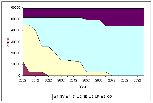
Figure A3. Number of acres in each stand structure for Landscape No Action alternative over time.
![]()
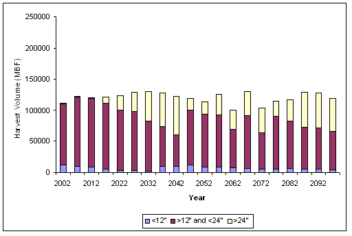
Figure A4. Harvest volume in three size classes for Private Alternative 3 through time.
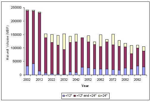
Figure A5. Harvest volume in three size classes for Landscape Alternative 2 through time.
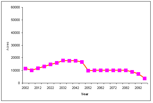
Figure A6. Number of acres within the target density range (Curtis' Relative Density 25-45) for BLM Alternative E through time.
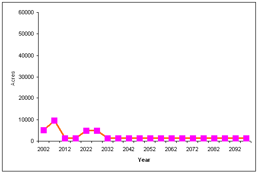
Figure A7. Number of acres within the target density range (Curtis' Relative Density 25-45) for Private No Action alternative through time.
![]()
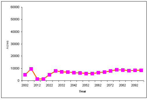
Figure A8. Number of acres within the target density range (Curtis' Relative Density 25-45) for Private Alternative 2 through time.
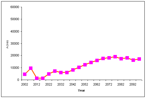
Figure A9. Number of acres within the target density range (Curtis' Relative Density 25-45) for Private Alternative 3 through time.
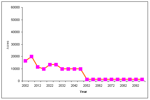
Figure A10. Number of acres within the target density range (Curtis' Relative Density 25-45) for Landscape No Action alternative through time.
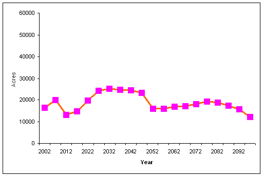
Figure A11. Number of acres within the target density range (Curtis' Relative Density 25-45) for Landscape Alternative 2 through time.
![]()
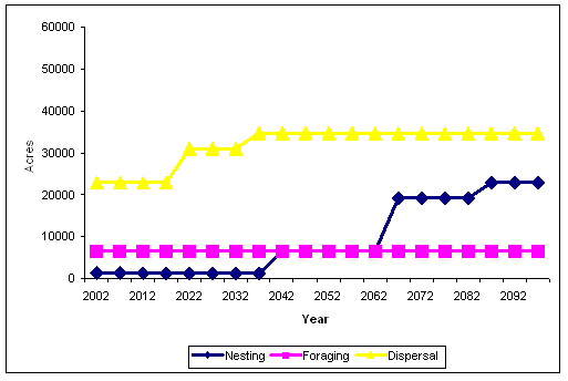
Figure A12. Number of acres in spotted owl habitat for Private No Action alternative through time.
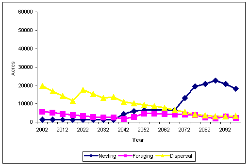
Figure A13. Number of acres in spotted owl habitat for Private Alternative 2 through time.
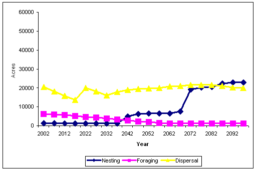
Figure A14. Number of acres in spotted owl habitat for Private Alternative 3 through time.
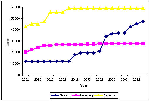
Figure A15. Number of acres in spotted owl habitat for Landscape No Action alternative through time.
![]()
Appendix B: Information and Files Concerning Modeling of BLM, Private, and Landscape Alternatives in LMS and Toggle
FVS keyword calibration file
COMMENT
KEYWORD 111111111 22222222 333333333 444444444 555555555 666666666
777777777
NUMCYCLE 10
VOLUME 6.0
4.5 1.0
MCDEFECT
0.25 0.20 0.20 0.15 0.15
END
SDIMAX 800
SDIMAX DF
600
SDIMAX WH
800
SDIMAX RC 600
SDIMAX RA
600
BAMAX 350
COMMENT
BFDEFECT 0.25
0.55 0.45
BFDEFECT RA
0.25 0.55
0.45
BAIMULT 0.75
MORTMULT 1.6
20
END
| Number of acres in each group for the BLM lands: | |
| Group | Acres |
| DF10 | 191 |
| DF15NoPCT | 1074 |
| DF15PCT | 704 |
| DF20 | 887 |
| DF25 | 1760 |
| DF30 | 2042 |
| DF35 | 2303 |
| DF40PCT | 419 |
| DF40NoPCT | 740 |
| DF45 | 1542 |
| DF55 | 1687 |
| DF65 | 377 |
| DF75 | 169 |
| DF95 | 1837 |
| DF135 | 322 |
| DF150 | 8462 |
| Number of acres in each group for the private lands: | |
| Group | Acres |
| Broadleaf3665 | 3665 |
| Mixed | 5175 |
| OpenForest | 3510 |
| SmallConifer | 8258 |
| MediumConifer | 12650 |
| LargeConifer | 1433 |
![]()
BLM Alternative E scenario file
#EndYear=2097
2012, DF10e_t1, pct40, T:40 W:D, DF, ZZ_NA, ZZ_NA, ZZ_NA, ZZ_NA,
A 120, ZZ_NA
2047, DF10e_t1, ct30, T:30 W:D, DF, ZZ_NA, ZZ_NA, ZZ_NA, ZZ_NA,
A 1600, V:C 100
2047, DF10e_t1, plantWH50RC50, ZZ_NA, ZZ_NA, ZZ_NA, ZZ_NA, WH50RC50.rgn,
ZZ_NA, A 75, ZZ_NA
2072, DF10e_t1, cwd17, T:22 W:D, DF, ZZ_NA, ZZ_NA, ZZ_NA, ZZ_NA,
A 50, ZZ_NA
2007, DF15NoPCTe_t1, pct50, T:50 W:D, DF, ZZ_NA, ZZ_NA, ZZ_NA, ZZ_NA,
A 120, ZZ_NA
2042, DF15NoPCTe_t1, ct30, T:30 W:D, DF, ZZ_NA, ZZ_NA, ZZ_NA, ZZ_NA,
A 1600, V:C 100
2042, DF15NoPCTe_t1, plantWH50RC50, ZZ_NA, ZZ_NA, ZZ_NA, ZZ_NA,
WH50RC50.rgn, ZZ_NA, A 75, ZZ_NA
2067, DF15NoPCTe_t1, cwd17, T:22 W:D, DF, ZZ_NA, ZZ_NA, ZZ_NA, ZZ_NA,
A 50, ZZ_NA
2007, DF15PCTe_t2, pct40, T:40 W:D, DF, ZZ_NA, ZZ_NA, ZZ_NA, ZZ_NA,
A 120, ZZ_NA
2042, DF15PCTe_t2, ct30, T:30 W:D, DF, ZZ_NA, ZZ_NA, ZZ_NA, ZZ_NA,
A 1600, V:C 100
2042, DF15PCTe_t2, plantWH50RC50, ZZ_NA, ZZ_NA, ZZ_NA, ZZ_NA, WH50RC50.rgn,
ZZ_NA, A 75, ZZ_NA
2067, DF15PCTe_t2, cwd17, T:22 W:D, DF, ZZ_NA, ZZ_NA, ZZ_NA, ZZ_NA,
A 50, ZZ_NA
2002, DF20e_t1, pct40, T:40 W:D, DF, ZZ_NA, ZZ_NA, ZZ_NA, ZZ_NA,
A 120, ZZ_NA
2042, DF20e_t1, ct30, T:30 W:D, DF, ZZ_NA, ZZ_NA, ZZ_NA, ZZ_NA,
A 1600, V:C 100
2042, DF20e_t1, plantWH50RC50, ZZ_NA, ZZ_NA, ZZ_NA, ZZ_NA, WH50RC50.rgn,
ZZ_NA, A 75, ZZ_NA
2052, DF20e_t1, cwd17, T:22 W:D, DF, ZZ_NA, ZZ_NA, ZZ_NA, ZZ_NA,
A 50, ZZ_NA
2007, DF25e_t1, pct40, T:40 P:D, DF, ZZ_NA, ZZ_NA, ZZ_NA, ZZ_NA,
A 900, V:C 100
2007, DF25e_t1, plantDF33WH33RC33, ZZ_NA, ZZ_NA, ZZ_NA, ZZ_NA, DF33WH33RC33.rgn,
ZZ_NA, A 75, ZZ_NA
2022, DF25e_t1, pct60DF, T:60 W:D, DF, ZZ_NA, ZZ_NA, ZZ_NA, ZZ_NA,
A 40, ZZ_NA
2022, DF25e_t1, pct20WH, T:20 W:D, WH, ZZ_NA, ZZ_NA, ZZ_NA, ZZ_NA,
A 40, ZZ_NA
2022, DF25e_t1, pct20RC, T:20 W:D, RC, ZZ_NA, ZZ_NA, ZZ_NA, ZZ_NA,
A 40, ZZ_NA
2047, DF25e_t1, pct10DF, T:10 W:D, DF, ZZ_NA, 0:20, ZZ_NA, ZZ_NA,
A 40, ZZ_NA
2047, DF25e_t1, pct10RC, T:10 W:D, RC, ZZ_NA, 0:20, ZZ_NA, ZZ_NA,
A 40, ZZ_NA
2047, DF25e_t1, pct10WH, T:10 W:D, WH, ZZ_NA, 0:20, ZZ_NA, ZZ_NA,
A 40, ZZ_NA
2047, DF25e_t1, plantWH25RC25, ZZ_NA, ZZ_NA, ZZ_NA, ZZ_NA, WH25RC25.rgn,
ZZ_NA, A 75, ZZ_NA
2057, DF25e_t1, cwd23above20, T:23 P:D, DF, ZZ_NA, 22:60, ZZ_NA,
ZZ_NA, A 50, ZZ_NA
2002, DF30e_t1, pct40, T:40 P:D, DF, ZZ_NA, ZZ_NA, ZZ_NA, ZZ_NA,
A 900, V:C 100
2002, DF30e_t1, plantDF33WH33RC33, ZZ_NA, ZZ_NA, ZZ_NA, ZZ_NA, DF33WH33RC33.rgn,
ZZ_NA, A 75, ZZ_NA
2017, DF30e_t1, pct20RC, T:20 W:D, RC, ZZ_NA, ZZ_NA, ZZ_NA, ZZ_NA,
A 40, ZZ_NA
2017, DF30e_t1, pct20WH, T:20 W:D, WH, ZZ_NA, ZZ_NA, ZZ_NA, ZZ_NA,
A 40, ZZ_NA
2017, DF30e_t1, pct60DF, T:60 W:D, DF, ZZ_NA, ZZ_NA, ZZ_NA, ZZ_NA,
A 40, ZZ_NA
2042, DF30e_t1, pct10DF, T:10 W:D, DF, ZZ_NA, 0:20, ZZ_NA, ZZ_NA,
A 40, ZZ_NA
2042, DF30e_t1, pct10RC, T:10 W:D, RC, ZZ_NA, 0:20, ZZ_NA, ZZ_NA,
A 40, ZZ_NA
2042, DF30e_t1, pct10WH, T:10 W:D, WH, ZZ_NA, 0:20, ZZ_NA, ZZ_NA,
A 40, ZZ_NA
2042, DF30e_t1, plantWH25RC25, ZZ_NA, ZZ_NA, ZZ_NA, ZZ_NA, WH25RC25.rgn,
ZZ_NA, A 75, ZZ_NA
2052, DF30e_t1, cwd23above20, T:23 P:D, DF, ZZ_NA, 22:60, ZZ_NA,
ZZ_NA, A 50, ZZ_NA
2012, DF35e_t1, pct40, T:40 P:D, DF, ZZ_NA, ZZ_NA, ZZ_NA, ZZ_NA,
A 1600, V:C 100
2012, DF35e_t1, plantDF33WH33RC33, ZZ_NA, ZZ_NA, ZZ_NA, ZZ_NA, DF33WH33RC33.rgn,
ZZ_NA, A 75, ZZ_NA
2032, DF35e_t1, pct17DF, T:17 W:D, DF, ZZ_NA, 0:20, ZZ_NA, ZZ_NA,
A 40, ZZ_NA
2032, DF35e_t1, pct17RC, T:17 W:D, RC, ZZ_NA, 0:20, ZZ_NA, ZZ_NA,
A 40, ZZ_NA
2032, DF35e_t1, pct17WH, T:17 W:D, WH, ZZ_NA, 0:20, ZZ_NA, ZZ_NA,
A 40, ZZ_NA
2042, DF35e_t1, cwd33above20, T:33 P:D, DF, ZZ_NA, 22:60, ZZ_NA,
ZZ_NA, A 50, ZZ_NA
2007, DF40NoPCTe_t1_37_40, pct40, T:40 P:D, DF, ZZ_NA, ZZ_NA, ZZ_NA,
ZZ_NA, A 1600, V:C 100
2007, DF40NoPCTe_t1_37_40, plantDF33WH33RC33, ZZ_NA, ZZ_NA, ZZ_NA,
ZZ_NA, DF33WH33RC33.rgn, ZZ_NA, A 75, ZZ_NA
2022, DF40NoPCTe_t1_37_40, pct10DF, T:17 W:D, DF, ZZ_NA, 0:20, ZZ_NA,
ZZ_NA, A 40, ZZ_NA
2022, DF40NoPCTe_t1_37_40, pct10RC, T:17 W:D, RC, ZZ_NA, 0:20, ZZ_NA,
ZZ_NA, A 40, ZZ_NA
2022, DF40NoPCTe_t1_37_40, pct10WH, T:17 W:D, WH, ZZ_NA, 0:20, ZZ_NA,
ZZ_NA, A 40, ZZ_NA
2037, DF40NoPCTe_t1_37_40, cwd33above20, T:33 P:D, DF, ZZ_NA, 22:60,
ZZ_NA, ZZ_NA, A 50, ZZ_NA
2007, DF40NoPCTe_t1_41_43, pct40, T:40 P:D, DF, ZZ_NA, ZZ_NA, ZZ_NA,
ZZ_NA, A 1600, V:C 100
2007, DF40NoPCTe_t1_41_43, plantDF33WH33RC33, ZZ_NA, ZZ_NA, ZZ_NA,
ZZ_NA, DF33WH33RC33.rgn, ZZ_NA, A 75, ZZ_NA
2022, DF40NoPCTe_t1_41_43, pct10DF, T:17 W:D, DF, ZZ_NA, 0:20, ZZ_NA,
ZZ_NA, A 40, ZZ_NA
2022, DF40NoPCTe_t1_41_43, pct10RC, T:17 W:D, RC, ZZ_NA, 0:20, ZZ_NA,
ZZ_NA, A 40, ZZ_NA
2022, DF40NoPCTe_t1_41_43, pct10WH, T:17 W:D, WH, ZZ_NA, 0:20, ZZ_NA,
ZZ_NA, A 40, ZZ_NA
2037, DF40NoPCTe_t1_41_43, cwd33above20, T:33 P:D, DF, ZZ_NA, 22:60,
ZZ_NA, ZZ_NA, A 50, ZZ_NA
2007, DF40PCTe_t1_37_40, pct40, T:40 W:D, DF, ZZ_NA, ZZ_NA, ZZ_NA,
ZZ_NA, A 1600, V:C 100
2007, DF40PCTe_t1_37_40, plantDF33WH33RC33, ZZ_NA, ZZ_NA, ZZ_NA,
ZZ_NA, DF33WH33RC33.rgn, ZZ_NA, A 75, ZZ_NA
2022, DF40PCTe_t1_37_40, pct10DF, T:17 W:D, DF, ZZ_NA, 0:20, ZZ_NA,
ZZ_NA, A 40, ZZ_NA
2022, DF40PCTe_t1_37_40, pct10RC, T:17 W:D, RC, ZZ_NA, 0:20, ZZ_NA,
ZZ_NA, A 40, ZZ_NA
2022, DF40PCTe_t1_37_40, pct10WH, T:17 W:D, WH, ZZ_NA, 0:20, ZZ_NA,
ZZ_NA, A 40, ZZ_NA
2037, DF40PCTe_t1_37_40, cwd33above20, T:33 P:D, DF, ZZ_NA, 22:60,
ZZ_NA, ZZ_NA, A 50, ZZ_NA
2007, DF40PCTe_t1_41_43, pct40, T:40 W:D, DF, ZZ_NA, ZZ_NA, ZZ_NA,
ZZ_NA, A 1600, V:C 100
2007, DF40PCTe_t1_41_43, plantDF33WH33RC33, ZZ_NA, ZZ_NA, ZZ_NA,
ZZ_NA, DF33WH33RC33.rgn, ZZ_NA, A 75, ZZ_NA
2022, DF40PCTe_t1_41_43, pct10DF, T:17 W:D, DF, ZZ_NA, 0:20, ZZ_NA,
ZZ_NA, A 40, ZZ_NA
2022, DF40PCTe_t1_41_43, pct10RC, T:17 W:D, RC, ZZ_NA, 0:20, ZZ_NA,
ZZ_NA, A 40, ZZ_NA
2022, DF40PCTe_t1_41_43, pct10WH, T:17 W:D, WH, ZZ_NA, 0:20, ZZ_NA,
ZZ_NA, A 40, ZZ_NA
2037, DF40PCTe_t1_41_43, cwd33above20, T:33 P:D, DF, ZZ_NA, 22:60,
ZZ_NA, ZZ_NA, A 50, ZZ_NA
2002, DF45e_t1, pct40, T:40 W:D, DF, ZZ_NA, ZZ_NA, ZZ_NA, ZZ_NA,
A 1600, V:C 100
2002, DF45e_t1, plantDF33WH33RC33, ZZ_NA, ZZ_NA, ZZ_NA, ZZ_NA, DF33WH33RC33.rgn,
ZZ_NA, A 75, ZZ_NA
2022, DF45e_t1, pct17DF, T:17 W:D, DF, ZZ_NA, 0:20, ZZ_NA, ZZ_NA,
A 40, ZZ_NA
2022, DF45e_t1, pct17RC, T:17 W:D, RC, ZZ_NA, 0:20, ZZ_NA, ZZ_NA,
A 40, ZZ_NA
2022, DF45e_t1, pct17WH, T:17 W:D, WH, ZZ_NA, 0:20, ZZ_NA, ZZ_NA,
A 40, ZZ_NA
2032, DF45e_t1, cwd33above20, T:33 P:D, DF, ZZ_NA, 22:60, ZZ_NA,
ZZ_NA, A 50, ZZ_NA
2007, DF55e_t1, pct40, T:40 P:D, DF, ZZ_NA, ZZ_NA, ZZ_NA, ZZ_NA,
A 1600, V:C 100
2007, DF55e_t1, plantWH50RC50, ZZ_NA, ZZ_NA, ZZ_NA, ZZ_NA, WH50RC50.rgn,
ZZ_NA, A 75, ZZ_NA
2022, DF55e_t1, pct25RC, T:25 W:D, RC, ZZ_NA, 0:20, ZZ_NA, ZZ_NA,
A 40, ZZ_NA
2022, DF55e_t1, pct25WH, T:25 P:D, WH, ZZ_NA, 0:20, ZZ_NA, ZZ_NA,
A 40, ZZ_NA
2022, DF55e_t1, cwd33above20, T:33 P:D, DF, ZZ_NA, 22:60, ZZ_NA,
ZZ_NA, A 50, ZZ_NA
2012, DF55e_t2, pct40, T:40 P:D, DF, ZZ_NA, ZZ_NA, ZZ_NA, ZZ_NA,
A 1600, V:C 100
2012, DF55e_t2, plantWH50RC50, ZZ_NA, ZZ_NA, ZZ_NA, ZZ_NA, WH50RC50.rgn,
ZZ_NA, A 75, ZZ_NA
2032, DF55e_t2, pct25RC, T:25 W:D, RC, ZZ_NA, 0:20, ZZ_NA, ZZ_NA,
A 40, ZZ_NA
2032, DF55e_t2, pct25WH, T:25 P:D, WH, ZZ_NA, 0:20, ZZ_NA, ZZ_NA,
A 40, ZZ_NA
2032, DF55e_t2, cwd33above20, T:33 P:D, DF, ZZ_NA, 22:60, ZZ_NA,
ZZ_NA, A 50, ZZ_NA
2002, DF65e_t1, pct40, T:40 P:D, DF, ZZ_NA, ZZ_NA, ZZ_NA, ZZ_NA,
A 1600, V:C 100
2002, DF65e_t1, plantWH50RC50, ZZ_NA, ZZ_NA, ZZ_NA, ZZ_NA, WH50RC50.rgn,
ZZ_NA, A 75, ZZ_NA
2002, DF65e_t2, pct40, T:40 P:D, DF, ZZ_NA, ZZ_NA, ZZ_NA, ZZ_NA,
A 1600, V:C 100
2002, DF65e_t2, plantWH50RC50, ZZ_NA, ZZ_NA, ZZ_NA, ZZ_NA, WH50RC50.rgn,
ZZ_NA, A 75, ZZ_NA
2022, DF65e_t2, pct25RC, T:25 W:D, RC, ZZ_NA, 0:20, ZZ_NA, ZZ_NA,
A 40, ZZ_NA
2022, DF65e_t2, pct25WH, T:25 P:D, WH, ZZ_NA, 0:20, ZZ_NA, ZZ_NA,
A 40, ZZ_NA
2022, DF65e_t2, cwd33above20, T:33 P:D, DF, ZZ_NA, 22:60, ZZ_NA,
ZZ_NA, A 50, ZZ_NA
2002, DF75e_t1, pct40, T:40 W:D, DF, ZZ_NA, ZZ_NA, ZZ_NA, ZZ_NA,
A 1600, V:C 100
2002, DF75e_t1, plantWH50RC50, ZZ_NA, ZZ_NA, ZZ_NA, ZZ_NA, WH50RC50.rgn,
ZZ_NA, A 75, ZZ_NA
![]()
Private Lands Alternative 2 scenario file
#EndYear=2097
;Mixed
2002, mixed7_8_9_10, Quick, T:2 W:D, DF, ZZ_NA, ZZ_NA, DF350.rgn,
ZZ_NA, ZZ_NA, ZZ_NA
2002, mixed7_8_9_10, Quick, T:0 P:D, ZZ_NA, DF, ZZ_NA, ZZ_NA, ZZ_NA,
ZZ_NA, ZZ_NA
2047, mixed7_8_9_10, Quick, T:2 W:D, ZZ_NA, ZZ_NA, ZZ_NA, DF350.rgn,
ZZ_NA, ZZ_NA, ZZ_NA
2092, mixed7_8_9_10, Quick, T:2 P:D, ZZ_NA, ZZ_NA, ZZ_NA, DF350.rgn,
ZZ_NA, ZZ_NA, ZZ_NA
2007, mixed7_8_9_10_2, Quick, T:2 W:D, DF, ZZ_NA, ZZ_NA, DF350.rgn,
ZZ_NA, ZZ_NA, ZZ_NA
2007, mixed7_8_9_10_2, Quick, T:0 P:D, ZZ_NA, DF, ZZ_NA, ZZ_NA,
ZZ_NA, ZZ_NA, ZZ_NA
2052, mixed7_8_9_10_2, Quick, T:2 W:D, ZZ_NA, ZZ_NA, ZZ_NA, DF350.rgn,
ZZ_NA, ZZ_NA, ZZ_NA
2097, mixed7_8_9_10_2, Quick, T:2 P:D, ZZ_NA, ZZ_NA, ZZ_NA, DF350.rgn,
ZZ_NA, ZZ_NA, ZZ_NA
2012, mixed7_8_9_10_3, Quick, T:2 W:D, DF, ZZ_NA, ZZ_NA, DF350.rgn,
ZZ_NA, ZZ_NA, ZZ_NA
2012, mixed7_8_9_10_3, Quick, T:0 P:D, ZZ_NA, DF, ZZ_NA, ZZ_NA,
ZZ_NA, ZZ_NA, ZZ_NA
2057, mixed7_8_9_10_3, Quick, T:2 W:D, ZZ_NA, ZZ_NA, ZZ_NA, DF350.rgn,
ZZ_NA, ZZ_NA, ZZ_NA
2017, mixed7_8_9_10_4, Quick, T:2 W:D, DF, ZZ_NA, ZZ_NA, DF350.rgn,
ZZ_NA, ZZ_NA, ZZ_NA
2017, mixed7_8_9_10_4, Quick, T:0 P:D, ZZ_NA, DF, ZZ_NA, ZZ_NA,
ZZ_NA, ZZ_NA, ZZ_NA
2062, mixed7_8_9_10_4, Quick, T:2 W:D, ZZ_NA, ZZ_NA, ZZ_NA, DF350.rgn,
ZZ_NA, ZZ_NA, ZZ_NA
2022, mixed7_8_9_10_5, Quick, T:2 W:D, DF, ZZ_NA, ZZ_NA, DF350.rgn,
ZZ_NA, ZZ_NA, ZZ_NA
2022, mixed7_8_9_10_5, Quick, T:0 P:D, ZZ_NA, DF, ZZ_NA, ZZ_NA,
ZZ_NA, ZZ_NA, ZZ_NA
2067, mixed7_8_9_10_5, Quick, T:2 W:D, ZZ_NA, ZZ_NA, ZZ_NA, DF350.rgn,
ZZ_NA, ZZ_NA, ZZ_NA
2027, mixed7_8_9_10_6, Quick, T:2 W:D, DF, ZZ_NA, ZZ_NA, DF350.rgn,
ZZ_NA, ZZ_NA, ZZ_NA
2027, mixed7_8_9_10_6, Quick, T:0 P:D, ZZ_NA, DF, ZZ_NA, ZZ_NA,
ZZ_NA, ZZ_NA, ZZ_NA
2072, mixed7_8_9_10_6, Quick, T:2 W:D, ZZ_NA, ZZ_NA, ZZ_NA, DF350.rgn,
ZZ_NA, ZZ_NA, ZZ_NA
2032, mixed7_8_9_10_7, Quick, T:2 W:D, DF, ZZ_NA, ZZ_NA, DF350.rgn,
ZZ_NA, ZZ_NA, ZZ_NA
2032, mixed7_8_9_10_7, Quick, T:0 P:D, ZZ_NA, DF, ZZ_NA, ZZ_NA,
ZZ_NA, ZZ_NA, ZZ_NA
2077, mixed7_8_9_10_7, Quick, T:2 W:D, ZZ_NA, ZZ_NA, ZZ_NA, DF350.rgn,
ZZ_NA, ZZ_NA, ZZ_NA
2037, mixed7_8_9_10_8, Quick, T:2 W:D, DF, ZZ_NA, ZZ_NA, DF350.rgn,
ZZ_NA, ZZ_NA, ZZ_NA
2037, mixed7_8_9_10_8, Quick, T:0 P:D, ZZ_NA, DF, ZZ_NA, ZZ_NA,
ZZ_NA, ZZ_NA, ZZ_NA
2082, mixed7_8_9_10_8, Quick, T:2 W:D, ZZ_NA, ZZ_NA, ZZ_NA, DF350.rgn,
ZZ_NA, ZZ_NA, ZZ_NA
2042, mixed7_8_9_10_9, Quick, T:2 W:D, DF, ZZ_NA, ZZ_NA, DF350.rgn,
ZZ_NA, ZZ_NA, ZZ_NA
2042, mixed7_8_9_10_9, Quick, T:0 P:D, ZZ_NA, DF, ZZ_NA, ZZ_NA,
ZZ_NA, ZZ_NA, ZZ_NA
2087, mixed7_8_9_10_9, Quick, T:2 W:D, ZZ_NA, ZZ_NA, ZZ_NA, DF350.rgn,
ZZ_NA, ZZ_NA, ZZ_NA
;MediumConifer
2002, mediumconifer12, Quick, T:2 W:D, DF, ZZ_NA, ZZ_NA, DF350.rgn,
ZZ_NA, ZZ_NA, ZZ_NA
2002, mediumconifer12, Quick, T:0 P:D, ZZ_NA, DF, ZZ_NA, ZZ_NA,
ZZ_NA, ZZ_NA, ZZ_NA
2047, mediumconifer12, Quick, T:2 W:D, ZZ_NA, ZZ_NA, ZZ_NA, DF350.rgn,
ZZ_NA, ZZ_NA, ZZ_NA
2092, mediumconifer12, Quick, T:2 P:D, ZZ_NA, ZZ_NA, ZZ_NA, DF350.rgn,
ZZ_NA, ZZ_NA, ZZ_NA
2007, mediumconifer12_2, Quick, T:2 W:D, DF, ZZ_NA, ZZ_NA, DF350.rgn,
ZZ_NA, ZZ_NA, ZZ_NA
2007, mediumconifer12_2, Quick, T:0 P:D, ZZ_NA, DF, ZZ_NA, ZZ_NA,
ZZ_NA, ZZ_NA, ZZ_NA
2052, mediumconifer12_2, Quick, T:2 W:D, ZZ_NA, ZZ_NA, ZZ_NA, DF350.rgn,
ZZ_NA, ZZ_NA, ZZ_NA
2097, mediumconifer12_2, Quick, T:2 P:D, ZZ_NA, ZZ_NA, ZZ_NA, DF350.rgn,
ZZ_NA, ZZ_NA, ZZ_NA
2012, mediumconifer12_3, Quick, T:2 W:D, DF, ZZ_NA, ZZ_NA, DF350.rgn,
ZZ_NA, ZZ_NA, ZZ_NA
2012, mediumconifer12_3, Quick, T:0 P:D, ZZ_NA, DF, ZZ_NA, ZZ_NA,
ZZ_NA, ZZ_NA, ZZ_NA
2057, mediumconifer12_3, Quick, T:2 W:D, ZZ_NA, ZZ_NA, ZZ_NA, DF350.rgn,
ZZ_NA, ZZ_NA, ZZ_NA
2017, mediumconifer12_4, Quick, T:2 W:D, DF, ZZ_NA, ZZ_NA, DF350.rgn,
ZZ_NA, ZZ_NA, ZZ_NA
2017, mediumconifer12_4, Quick, T:0 P:D, ZZ_NA, DF, ZZ_NA, ZZ_NA,
ZZ_NA, ZZ_NA, ZZ_NA
2062, mediumconifer12_4, Quick, T:2 W:D, ZZ_NA, ZZ_NA, ZZ_NA, DF350.rgn,
ZZ_NA, ZZ_NA, ZZ_NA
2022, mediumconifer12_5, Quick, T:2 W:D, DF, ZZ_NA, ZZ_NA, DF350.rgn,
ZZ_NA, ZZ_NA, ZZ_NA
2022, mediumconifer12_5, Quick, T:0 P:D, ZZ_NA, DF, ZZ_NA, ZZ_NA,
ZZ_NA, ZZ_NA, ZZ_NA
2067, mediumconifer12_5, Quick, T:2 W:D, ZZ_NA, ZZ_NA, ZZ_NA, DF350.rgn,
ZZ_NA, ZZ_NA, ZZ_NA
2027, mediumconifer12_6, Quick, T:2 W:D, DF, ZZ_NA, ZZ_NA, DF350.rgn,
ZZ_NA, ZZ_NA, ZZ_NA
2027, mediumconifer12_6, Quick, T:0 P:D, ZZ_NA, DF, ZZ_NA, ZZ_NA,
ZZ_NA, ZZ_NA, ZZ_NA
2072, mediumconifer12_6, Quick, T:2 W:D, ZZ_NA, ZZ_NA, ZZ_NA, DF350.rgn,
ZZ_NA, ZZ_NA, ZZ_NA
2032, mediumconifer12_7, Quick, T:2 W:D, DF, ZZ_NA, ZZ_NA, DF350.rgn,
ZZ_NA, ZZ_NA, ZZ_NA
2032, mediumconifer12_7, Quick, T:0 P:D, ZZ_NA, DF, ZZ_NA, ZZ_NA,
ZZ_NA, ZZ_NA, ZZ_NA
2077, mediumconifer12_7, Quick, T:2 W:D, ZZ_NA, ZZ_NA, ZZ_NA, DF350.rgn,
ZZ_NA, ZZ_NA, ZZ_NA
2037, mediumconifer12_8, Quick, T:2 W:D, DF, ZZ_NA, ZZ_NA, DF350.rgn,
ZZ_NA, ZZ_NA, ZZ_NA
2037, mediumconifer12_8, Quick, T:0 P:D, ZZ_NA, DF, ZZ_NA, ZZ_NA,
ZZ_NA, ZZ_NA, ZZ_NA
2082, mediumconifer12_8, Quick, T:2 W:D, ZZ_NA, ZZ_NA, ZZ_NA, DF350.rgn,
ZZ_NA, ZZ_NA, ZZ_NA
2042, mediumconifer12_9, Quick, T:2 W:D, DF, ZZ_NA, ZZ_NA, DF350.rgn,
ZZ_NA, ZZ_NA, ZZ_NA
2042, mediumconifer12_9, Quick, T:0 P:D, ZZ_NA, DF, ZZ_NA, ZZ_NA,
ZZ_NA, ZZ_NA, ZZ_NA
2087, mediumconifer12_9, Quick, T:2 W:D, ZZ_NA, ZZ_NA, ZZ_NA, DF350.rgn,
ZZ_NA, ZZ_NA, ZZ_NA
![]()
Private Lands Alternative 3 scenario file
#EndYear=2097
;mediumconifer
2002, mediumconifer12, Quick, T:2 W:D, DF, ZZ_NA, ZZ_NA, DF350.rgn,
ZZ_NA, ZZ_NA, ZZ_NA
2002, mediumconifer12, Quick, T:0 W:D, ZZ_NA, DF, ZZ_NA, ZZ_NA,
ZZ_NA, ZZ_NA, ZZ_NA
2037, mediumconifer12, Quick, T:100 W:D, ZZ_NA, ZZ_NA, ZZ_NA, ZZ_NA,
ZZ_NA, ZZ_NA, ZZ_NA
2087, mediumconifer12, Quick, T:2 W:D, ZZ_NA, ZZ_NA, ZZ_NA, DF350.rgn,
ZZ_NA, ZZ_NA, ZZ_NA
2007, mediumconifer12_2, Quick, T:2 W:D, DF, ZZ_NA, ZZ_NA, DF350.rgn,
ZZ_NA, ZZ_NA, ZZ_NA
2007, mediumconifer12_2, Quick, T:0 W:D, ZZ_NA, DF, ZZ_NA, ZZ_NA,
ZZ_NA, ZZ_NA, ZZ_NA
2042, mediumconifer12_2, Quick, T:100 W:D, ZZ_NA, ZZ_NA, ZZ_NA,
ZZ_NA, ZZ_NA, ZZ_NA, ZZ_NA
2092, mediumconifer12_2, Quick, T:2 W:D, ZZ_NA, ZZ_NA, ZZ_NA, DF350.rgn,
ZZ_NA, ZZ_NA, ZZ_NA
2012, mediumconifer12_3, Quick, T:2 W:D, DF, ZZ_NA, ZZ_NA, DF350.rgn,
ZZ_NA, ZZ_NA, ZZ_NA
2012, mediumconifer12_3, Quick, T:0 W:D, ZZ_NA, DF, ZZ_NA, ZZ_NA,
ZZ_NA, ZZ_NA, ZZ_NA
2047, mediumconifer12_3, Quick, T:100 W:D, ZZ_NA, ZZ_NA, ZZ_NA,
ZZ_NA, ZZ_NA, ZZ_NA, ZZ_NA
2097, mediumconifer12_3, Quick, T:2 W:D, ZZ_NA, ZZ_NA, ZZ_NA, DF350.rgn,
ZZ_NA, ZZ_NA, ZZ_NA
2017, mediumconifer12_4, Quick, T:2 W:D, DF, ZZ_NA, ZZ_NA, DF350.rgn,
ZZ_NA, ZZ_NA, ZZ_NA
2017, mediumconifer12_4, Quick, T:0 W:D, ZZ_NA, DF, ZZ_NA, ZZ_NA,
ZZ_NA, ZZ_NA, ZZ_NA
2052, mediumconifer12_4, Quick, T:100 W:D, ZZ_NA, ZZ_NA, ZZ_NA,
ZZ_NA, ZZ_NA, ZZ_NA, ZZ_NA
2022, mediumconifer12_5, Quick, T:2 W:D, DF, ZZ_NA, ZZ_NA, DF350.rgn,
ZZ_NA, ZZ_NA, ZZ_NA
2022, mediumconifer12_5, Quick, T:0 W:D, ZZ_NA, DF, ZZ_NA, ZZ_NA,
ZZ_NA, ZZ_NA, ZZ_NA
2057, mediumconifer12_5, Quick, T:100 W:D, ZZ_NA, ZZ_NA, ZZ_NA,
ZZ_NA, ZZ_NA, ZZ_NA, ZZ_NA
2027, mediumconifer12_6, Quick, T:2 W:D, DF, ZZ_NA, ZZ_NA, DF350.rgn,
ZZ_NA, ZZ_NA, ZZ_NA
2027, mediumconifer12_6, Quick, T:0 W:D, ZZ_NA, DF, ZZ_NA, ZZ_NA,
ZZ_NA, ZZ_NA, ZZ_NA
2062, mediumconifer12_6, Quick, T:100 W:D, ZZ_NA, ZZ_NA, ZZ_NA,
ZZ_NA, ZZ_NA, ZZ_NA, ZZ_NA
2032, mediumconifer12_7, Quick, T:2 W:D, DF, ZZ_NA, ZZ_NA, DF350.rgn,
ZZ_NA, ZZ_NA, ZZ_NA
2032, mediumconifer12_7, Quick, T:0 W:D, ZZ_NA, DF, ZZ_NA, ZZ_NA,
ZZ_NA, ZZ_NA, ZZ_NA
2067, mediumconifer12_7, Quick, T:100 W:D, ZZ_NA, ZZ_NA, ZZ_NA,
ZZ_NA, ZZ_NA, ZZ_NA, ZZ_NA
2037, mediumconifer12_8, Quick, T:2 W:D, DF, ZZ_NA, ZZ_NA, DF350.rgn,
ZZ_NA, ZZ_NA, ZZ_NA
2037, mediumconifer12_8, Quick, T:0 W:D, ZZ_NA, DF, ZZ_NA, ZZ_NA,
ZZ_NA, ZZ_NA, ZZ_NA
2072, mediumconifer12_8, Quick, T:100 W:D, ZZ_NA, ZZ_NA, ZZ_NA,
ZZ_NA, ZZ_NA, ZZ_NA, ZZ_NA
2042, mediumconifer12_9, Quick, T:2 W:D, DF, ZZ_NA, ZZ_NA, DF350.rgn,
ZZ_NA, ZZ_NA, ZZ_NA
2042, mediumconifer12_9, Quick, T:0 W:D, ZZ_NA, DF, ZZ_NA, ZZ_NA,
ZZ_NA, ZZ_NA, ZZ_NA
2077, mediumconifer12_9, Quick, T:100 W:D, ZZ_NA, ZZ_NA, ZZ_NA,
ZZ_NA, ZZ_NA, ZZ_NA, ZZ_NA
2047, mediumconifer12_10, Quick, T:2 W:D, DF, ZZ_NA, ZZ_NA, DF350.rgn,
ZZ_NA, ZZ_NA, ZZ_NA
2047, mediumconifer12_10, Quick, T:0 W:D, ZZ_NA, DF, ZZ_NA, ZZ_NA,
ZZ_NA, ZZ_NA, ZZ_NA
2082, mediumconifer12_10, Quick, T:100 W:D, ZZ_NA, ZZ_NA, ZZ_NA,
ZZ_NA, ZZ_NA, ZZ_NA, ZZ_NA
2002, mediumconifer12_11, Quick, T:100 W:D, ZZ_NA, ZZ_NA, ZZ_NA,
ZZ_NA, ZZ_NA, ZZ_NA, ZZ_NA
2052, mediumconifer12_11, Quick, T:2 W:D, DF, ZZ_NA, ZZ_NA, DF350.rgn,
ZZ_NA, ZZ_NA, ZZ_NA
2052, mediumconifer12_11, Quick, T:0 W:D, ZZ_NA, DF, ZZ_NA, ZZ_NA,
ZZ_NA, ZZ_NA, ZZ_NA
2087, mediumconifer12_11, Quick, T:100 W:D, ZZ_NA, ZZ_NA, ZZ_NA,
ZZ_NA, ZZ_NA, ZZ_NA, ZZ_NA
2007, mediumconifer12_11, Quick, T:100 W:D, ZZ_NA, ZZ_NA, ZZ_NA,
ZZ_NA, ZZ_NA, ZZ_NA, ZZ_NA
2057, mediumconifer12_12, Quick, T:2 W:D, DF, ZZ_NA, ZZ_NA, DF350.rgn,
ZZ_NA, ZZ_NA, ZZ_NA
2057, mediumconifer12_12, Quick, T:0 W:D, ZZ_NA, DF, ZZ_NA, ZZ_NA,
ZZ_NA, ZZ_NA, ZZ_NA
2092, mediumconifer12_12, Quick, T:100 W:D, ZZ_NA, ZZ_NA, ZZ_NA,
ZZ_NA, ZZ_NA, ZZ_NA, ZZ_NA
2012, mediumconifer12_11, Quick, T:100 W:D, ZZ_NA, ZZ_NA, ZZ_NA,
ZZ_NA, ZZ_NA, ZZ_NA, ZZ_NA
2062, mediumconifer12_13, Quick, T:2 W:D, DF, ZZ_NA, ZZ_NA, DF350.rgn,
ZZ_NA, ZZ_NA, ZZ_NA
2062, mediumconifer12_13, Quick, T:0 W:D, ZZ_NA, DF, ZZ_NA, ZZ_NA,
ZZ_NA, ZZ_NA, ZZ_NA
2097, mediumconifer12_13, Quick, T:100 W:D, ZZ_NA, ZZ_NA, ZZ_NA,
ZZ_NA, ZZ_NA, ZZ_NA, ZZ_NA
;mixed7_8_9__10
2002, mixed7_8_9_10, Quick, T:2 W:D, DF, ZZ_NA, ZZ_NA, DF350.rgn,
ZZ_NA, ZZ_NA, ZZ_NA
2002, mixed7_8_9_10, Quick, T:0 W:D, ZZ_NA, DF, ZZ_NA, ZZ_NA, ZZ_NA,
ZZ_NA, ZZ_NA
2037, mixed7_8_9_10, Quick, T:100 W:D, ZZ_NA, ZZ_NA, ZZ_NA, ZZ_NA,
ZZ_NA, ZZ_NA, ZZ_NA
2087, mixed7_8_9_10, Quick, T:2 W:D, ZZ_NA, ZZ_NA, ZZ_NA, DF350.rgn,
ZZ_NA, ZZ_NA, ZZ_NA
2007, mixed7_8_9_10_2, Quick, T:2 W:D, DF, ZZ_NA, ZZ_NA, DF350.rgn,
ZZ_NA, ZZ_NA, ZZ_NA
2007, mixed7_8_9_10_2, Quick, T:0 W:D, ZZ_NA, DF, ZZ_NA, ZZ_NA,
ZZ_NA, ZZ_NA, ZZ_NA
2042, mixed7_8_9_10_2, Quick, T:100 W:D, ZZ_NA, ZZ_NA, ZZ_NA, ZZ_NA,
ZZ_NA, ZZ_NA, ZZ_NA
2092, mixed7_8_9_10_2, Quick, T:2 W:D, ZZ_NA, ZZ_NA, ZZ_NA, DF350.rgn,
ZZ_NA, ZZ_NA, ZZ_NA
2012, mixed7_8_9_10_3, Quick, T:2 W:D, DF, ZZ_NA, ZZ_NA, DF350.rgn,
ZZ_NA, ZZ_NA, ZZ_NA
2012, mixed7_8_9_10_3, Quick, T:0 W:D, ZZ_NA, DF, ZZ_NA, ZZ_NA,
ZZ_NA, ZZ_NA, ZZ_NA
2047, mixed7_8_9_10_3, Quick, T:100 W:D, ZZ_NA, ZZ_NA, ZZ_NA, ZZ_NA,
ZZ_NA, ZZ_NA, ZZ_NA
2097, mixed7_8_9_10_3, Quick, T:2 W:D, ZZ_NA, ZZ_NA, ZZ_NA, DF350.rgn,
ZZ_NA, ZZ_NA, ZZ_NA
2017, mixed7_8_9_10_4, Quick, T:2 W:D, DF, ZZ_NA, ZZ_NA, DF350.rgn,
ZZ_NA, ZZ_NA, ZZ_NA
2017, mixed7_8_9_10_4, Quick, T:0 W:D, ZZ_NA, DF, ZZ_NA, ZZ_NA,
ZZ_NA, ZZ_NA, ZZ_NA
2052, mixed7_8_9_10_4, Quick, T:100 W:D, ZZ_NA, ZZ_NA, ZZ_NA, ZZ_NA,
ZZ_NA, ZZ_NA, ZZ_NA
2022, mixed7_8_9_10_5, Quick, T:2 W:D, DF, ZZ_NA, ZZ_NA, DF350.rgn,
ZZ_NA, ZZ_NA, ZZ_NA
2022, mixed7_8_9_10_5, Quick, T:0 W:D, ZZ_NA, DF, ZZ_NA, ZZ_NA,
ZZ_NA, ZZ_NA, ZZ_NA
2057, mixed7_8_9_10_5, Quick, T:100 W:D, ZZ_NA, ZZ_NA, ZZ_NA, ZZ_NA,
ZZ_NA, ZZ_NA, ZZ_NA
2027, mixed7_8_9_10_6, Quick, T:2 W:D, DF, ZZ_NA, ZZ_NA, DF350.rgn,
ZZ_NA, ZZ_NA, ZZ_NA
2027, mixed7_8_9_10_6, Quick, T:0 W:D, ZZ_NA, DF, ZZ_NA, ZZ_NA,
ZZ_NA, ZZ_NA, ZZ_NA
2062, mixed7_8_9_10_6, Quick, T:100 W:D, ZZ_NA, ZZ_NA, ZZ_NA, ZZ_NA,
ZZ_NA, ZZ_NA, ZZ_NA
2032, mixed7_8_9_10_7, Quick, T:2 W:D, DF, ZZ_NA, ZZ_NA, DF350.rgn,
ZZ_NA, ZZ_NA, ZZ_NA
2032, mixed7_8_9_10_7, Quick, T:0 W:D, ZZ_NA, DF, ZZ_NA, ZZ_NA,
ZZ_NA, ZZ_NA, ZZ_NA
2067, mixed7_8_9_10_7, Quick, T:100 W:D, ZZ_NA, ZZ_NA, ZZ_NA, ZZ_NA,
ZZ_NA, ZZ_NA, ZZ_NA
2037, mixed7_8_9_10_8, Quick, T:2 W:D, DF, ZZ_NA, ZZ_NA, DF350.rgn,
ZZ_NA, ZZ_NA, ZZ_NA
2037, mixed7_8_9_10_8, Quick, T:0 W:D, ZZ_NA, DF, ZZ_NA, ZZ_NA,
ZZ_NA, ZZ_NA, ZZ_NA
2072, mixed7_8_9_10_8, Quick, T:100 W:D, ZZ_NA, ZZ_NA, ZZ_NA, ZZ_NA,
ZZ_NA, ZZ_NA, ZZ_NA
2042, mixed7_8_9_10_9, Quick, T:2 W:D, DF, ZZ_NA, ZZ_NA, DF350.rgn,
ZZ_NA, ZZ_NA, ZZ_NA
2042, mixed7_8_9_10_9, Quick, T:0 W:D, ZZ_NA, DF, ZZ_NA, ZZ_NA,
ZZ_NA, ZZ_NA, ZZ_NA
2077, mixed7_8_9_10_9, Quick, T:100 W:D, ZZ_NA, ZZ_NA, ZZ_NA, ZZ_NA,
ZZ_NA, ZZ_NA, ZZ_NA
2047, mixed7_8_9_10_10, Quick, T:2 W:D, DF, ZZ_NA, ZZ_NA, DF350.rgn,
ZZ_NA, ZZ_NA, ZZ_NA
2047, mixed7_8_9_10_10, Quick, T:0 W:D, ZZ_NA, DF, ZZ_NA, ZZ_NA,
ZZ_NA, ZZ_NA, ZZ_NA
2082, mixed7_8_9_10_10, Quick, T:100 W:D, ZZ_NA, ZZ_NA, ZZ_NA, ZZ_NA,
ZZ_NA, ZZ_NA, ZZ_NA
2052, mixed7_8_9_10_11, Quick, T:2 W:D, DF, ZZ_NA, ZZ_NA, DF350.rgn,
ZZ_NA, ZZ_NA, ZZ_NA
2052, mixed7_8_9_10_11, Quick, T:0 W:D, ZZ_NA, DF, ZZ_NA, ZZ_NA,
ZZ_NA, ZZ_NA, ZZ_NA
2087, mixed7_8_9_10_11, Quick, T:100 W:D, ZZ_NA, ZZ_NA, ZZ_NA, ZZ_NA,
ZZ_NA, ZZ_NA, ZZ_NA
2057, mixed7_8_9_10_12, Quick, T:2 W:D, DF, ZZ_NA, ZZ_NA, DF350.rgn,
ZZ_NA, ZZ_NA, ZZ_NA
2057, mixed7_8_9_10_12, Quick, T:0 W:D, ZZ_NA, DF, ZZ_NA, ZZ_NA,
ZZ_NA, ZZ_NA, ZZ_NA
2092, mixed7_8_9_10_12, Quick, T:100 W:D, ZZ_NA, ZZ_NA, ZZ_NA, ZZ_NA,
ZZ_NA, ZZ_NA, ZZ_NA
2062, mixed7_8_9_10_13, Quick, T:2 W:D, DF, ZZ_NA, ZZ_NA, DF350.rgn,
ZZ_NA, ZZ_NA, ZZ_NA
2062, mixed7_8_9_10_13, Quick, T:0 W:D, ZZ_NA, DF, ZZ_NA, ZZ_NA,
ZZ_NA, ZZ_NA, ZZ_NA
2097, mixed7_8_9_10_13, Quick, T:100 W:D, ZZ_NA, ZZ_NA, ZZ_NA, ZZ_NA,
ZZ_NA, ZZ_NA, ZZ_NA
;openforest
2042, openforest3, Quick, T:2 W:D, DF, ZZ_NA, ZZ_NA, DF350.rgn,
ZZ_NA, ZZ_NA, ZZ_NA
2042, openforest3, Quick, T:0 W:D, ZZ_NA, DF, ZZ_NA, ZZ_NA, ZZ_NA,
ZZ_NA, ZZ_NA
2077, openforest3, Quick, T:100 W:D, ZZ_NA, ZZ_NA, ZZ_NA, ZZ_NA,
ZZ_NA, ZZ_NA, ZZ_NA
2047, openforest3_2, Quick, T:2 W:D, DF, ZZ_NA, ZZ_NA, DF350.rgn,
ZZ_NA, ZZ_NA, ZZ_NA
2047, openforest3_2, Quick, T:0 W:D, ZZ_NA, DF, ZZ_NA, ZZ_NA, ZZ_NA,
ZZ_NA, ZZ_NA
2082, openforest3_2, Quick, T:100 W:D, ZZ_NA, ZZ_NA, ZZ_NA, ZZ_NA,
ZZ_NA, ZZ_NA, ZZ_NA
2052, openforest3_3, Quick, T:2 W:D, DF, ZZ_NA, ZZ_NA, DF350.rgn,
ZZ_NA, ZZ_NA, ZZ_NA
2052, openforest3_3, Quick, T:0 W:D, ZZ_NA, DF, ZZ_NA, ZZ_NA, ZZ_NA,
ZZ_NA, ZZ_NA
2087, openforest3_3, Quick, T:100 W:D, ZZ_NA, ZZ_NA, ZZ_NA, ZZ_NA,
ZZ_NA, ZZ_NA, ZZ_NA
2057, openforest3_4, Quick, T:2 W:D, DF, ZZ_NA, ZZ_NA, DF350.rgn,
ZZ_NA, ZZ_NA, ZZ_NA
2057, openforest3_4, Quick, T:0 W:D, ZZ_NA, DF, ZZ_NA, ZZ_NA, ZZ_NA,
ZZ_NA, ZZ_NA
2092, openforest3_4, Quick, T:100 W:D, ZZ_NA, ZZ_NA, ZZ_NA, ZZ_NA,
ZZ_NA, ZZ_NA, ZZ_NA
2062, openforest3_5, Quick, T:2 W:D, DF, ZZ_NA, ZZ_NA, DF350.rgn,
ZZ_NA, ZZ_NA, ZZ_NA
2062, openforest3_5, Quick, T:0 W:D, ZZ_NA, DF, ZZ_NA, ZZ_NA, ZZ_NA,
ZZ_NA, ZZ_NA
2097, openforest3_5, Quick, T:100 W:D, ZZ_NA, ZZ_NA, ZZ_NA, ZZ_NA,
ZZ_NA, ZZ_NA, ZZ_NA
2067, openforest3_6, Quick, T:2 W:D, DF, ZZ_NA, ZZ_NA, DF350.rgn,
ZZ_NA, ZZ_NA, ZZ_NA
2067, openforest3_6, Quick, T:0 W:D, ZZ_NA, DF, ZZ_NA, ZZ_NA, ZZ_NA,
ZZ_NA, ZZ_NA
2072, openforest3_7, Quick, T:2 W:D, DF, ZZ_NA, ZZ_NA, DF350.rgn,
ZZ_NA, ZZ_NA, ZZ_NA
2072, openforest3_7, Quick, T:0 W:D, ZZ_NA, DF, ZZ_NA, ZZ_NA, ZZ_NA,
ZZ_NA, ZZ_NA
2077, openforest3_8, Quick, T:2 W:D, DF, ZZ_NA, ZZ_NA, DF350.rgn,
ZZ_NA, ZZ_NA, ZZ_NA
2077, openforest3_8, Quick, T:0 W:D, ZZ_NA, DF, ZZ_NA, ZZ_NA, ZZ_NA,
ZZ_NA, ZZ_NA
2082, openforest3_9, Quick, T:2 W:D, DF, ZZ_NA, ZZ_NA, DF350.rgn,
ZZ_NA, ZZ_NA, ZZ_NA
2082, openforest3_9, Quick, T:0 W:D, ZZ_NA, DF, ZZ_NA, ZZ_NA, ZZ_NA,
ZZ_NA, ZZ_NA
2087, openforest3_10, Quick, T:2 W:D, DF, ZZ_NA, ZZ_NA, DF350.rgn,
ZZ_NA, ZZ_NA, ZZ_NA
2087, openforest3_10, Quick, T:0 W:D, ZZ_NA, DF, ZZ_NA, ZZ_NA, ZZ_NA,
ZZ_NA, ZZ_NA
2092, openforest3_11, Quick, T:2 W:D, DF, ZZ_NA, ZZ_NA, DF350.rgn,
ZZ_NA, ZZ_NA, ZZ_NA
2092, openforest3_11, Quick, T:0 W:D, ZZ_NA, DF, ZZ_NA, ZZ_NA, ZZ_NA,
ZZ_NA, ZZ_NA
2097, openforest3_12, Quick, T:2 W:D, DF, ZZ_NA, ZZ_NA, DF350.rgn,
ZZ_NA, ZZ_NA, ZZ_NA
2097, openforest3_12, Quick, T:0 W:D, ZZ_NA, DF, ZZ_NA, ZZ_NA, ZZ_NA,
ZZ_NA, ZZ_NA
;smallconifer
2042, smallconifer11, Quick, T:2 W:D, DF, ZZ_NA, ZZ_NA, DF350.rgn,
ZZ_NA, ZZ_NA, ZZ_NA
2042, smallconifer11, Quick, T:0 W:D, ZZ_NA, DF, ZZ_NA, ZZ_NA, ZZ_NA,
ZZ_NA, ZZ_NA
2077, smallconifer11, Quick, T:100 W:D, ZZ_NA, ZZ_NA, ZZ_NA, ZZ_NA,
ZZ_NA, ZZ_NA, ZZ_NA
2047, smallconifer11_2, Quick, T:2 W:D, DF, ZZ_NA, ZZ_NA, DF350.rgn,
ZZ_NA, ZZ_NA, ZZ_NA
2047, smallconifer11_2, Quick, T:0 W:D, ZZ_NA, DF, ZZ_NA, ZZ_NA,
ZZ_NA, ZZ_NA, ZZ_NA
2082, smallconifer11_2, Quick, T:100 W:D, ZZ_NA, ZZ_NA, ZZ_NA, ZZ_NA,
ZZ_NA, ZZ_NA, ZZ_NA
2052, smallconifer11_3, Quick, T:2 W:D, DF, ZZ_NA, ZZ_NA, DF350.rgn,
ZZ_NA, ZZ_NA, ZZ_NA
2052, smallconifer11_3, Quick, T:0 W:D, ZZ_NA, DF, ZZ_NA, ZZ_NA,
ZZ_NA, ZZ_NA, ZZ_NA
2087, smallconifer11_3, Quick, T:100 W:D, ZZ_NA, ZZ_NA, ZZ_NA, ZZ_NA,
ZZ_NA, ZZ_NA, ZZ_NA
2057, smallconifer11_4, Quick, T:2 W:D, DF, ZZ_NA, ZZ_NA, DF350.rgn,
ZZ_NA, ZZ_NA, ZZ_NA
2057, smallconifer11_4, Quick, T:0 W:D, ZZ_NA, DF, ZZ_NA, ZZ_NA,
ZZ_NA, ZZ_NA, ZZ_NA
2092, smallconifer11_4, Quick, T:100 W:D, ZZ_NA, ZZ_NA, ZZ_NA, ZZ_NA,
ZZ_NA, ZZ_NA, ZZ_NA
2062, smallconifer11_5, Quick, T:2 W:D, DF, ZZ_NA, ZZ_NA, DF350.rgn,
ZZ_NA, ZZ_NA, ZZ_NA
2062, smallconifer11_5, Quick, T:0 W:D, ZZ_NA, DF, ZZ_NA, ZZ_NA,
ZZ_NA, ZZ_NA, ZZ_NA
2097, smallconifer11_5, Quick, T:100 W:D, ZZ_NA, ZZ_NA, ZZ_NA, ZZ_NA,
ZZ_NA, ZZ_NA, ZZ_NA
2067, smallconifer11_6, Quick, T:2 W:D, DF, ZZ_NA, ZZ_NA, DF350.rgn,
ZZ_NA, ZZ_NA, ZZ_NA
2067, smallconifer11_6, Quick, T:0 W:D, ZZ_NA, DF, ZZ_NA, ZZ_NA,
ZZ_NA, ZZ_NA, ZZ_NA
2072, smallconifer11_7, Quick, T:2 W:D, DF, ZZ_NA, ZZ_NA, DF350.rgn,
ZZ_NA, ZZ_NA, ZZ_NA
2072, smallconifer11_7, Quick, T:0 W:D, ZZ_NA, DF, ZZ_NA, ZZ_NA,
ZZ_NA, ZZ_NA, ZZ_NA
2077, smallconifer11_8, Quick, T:2 W:D, DF, ZZ_NA, ZZ_NA, DF350.rgn,
ZZ_NA, ZZ_NA, ZZ_NA
2077, smallconifer11_8, Quick, T:0 W:D, ZZ_NA, DF, ZZ_NA, ZZ_NA,
ZZ_NA, ZZ_NA, ZZ_NA
2082, smallconifer11_9, Quick, T:2 W:D, DF, ZZ_NA, ZZ_NA, DF350.rgn,
ZZ_NA, ZZ_NA, ZZ_NA
2082, smallconifer11_9, Quick, T:0 W:D, ZZ_NA, DF, ZZ_NA, ZZ_NA,
ZZ_NA, ZZ_NA, ZZ_NA
2087, smallconifer11_10, Quick, T:2 W:D, DF, ZZ_NA, ZZ_NA, DF350.rgn,
ZZ_NA, ZZ_NA, ZZ_NA
2087, smallconifer11_10, Quick, T:0 W:D, ZZ_NA, DF, ZZ_NA, ZZ_NA,
ZZ_NA, ZZ_NA, ZZ_NA
2092, smallconifer11_11, Quick, T:2 W:D, DF, ZZ_NA, ZZ_NA, DF350.rgn,
ZZ_NA, ZZ_NA, ZZ_NA
2092, smallconifer11_11, Quick, T:0 W:D, ZZ_NA, DF, ZZ_NA, ZZ_NA,
ZZ_NA, ZZ_NA, ZZ_NA
2097, smallconifer11_12, Quick, T:2 W:D, DF, ZZ_NA, ZZ_NA, DF350.rgn,
ZZ_NA, ZZ_NA, ZZ_NA
2097, smallconifer11_12, Quick, T:0 W:D, ZZ_NA, DF, ZZ_NA, ZZ_NA,
ZZ_NA, ZZ_NA, ZZ_NA
;broadleaf
2002, broadleaf6, Quick, T:2 W:D, DF, ZZ_NA, ZZ_NA, DF350.rgn, ZZ_NA,
ZZ_NA, ZZ_NA
2002, broadleaf6, Quick, T:0 W:D, ZZ_NA, DF, ZZ_NA, ZZ_NA, ZZ_NA,
ZZ_NA, ZZ_NA
2037, broadleaf6, Quick, T:100 W:D, ZZ_NA, ZZ_NA, ZZ_NA, ZZ_NA,
ZZ_NA, ZZ_NA, ZZ_NA
2087, broadleaf6, Quick, T:2 W:D, ZZ_NA, ZZ_NA, ZZ_NA, DF350.rgn,
ZZ_NA, ZZ_NA, ZZ_NA
2007, broadleaf6_2, Quick, T:2 W:D, DF, ZZ_NA, ZZ_NA, DF350.rgn,
ZZ_NA, ZZ_NA, ZZ_NA
2007, broadleaf6_2, Quick, T:0 W:D, ZZ_NA, DF, ZZ_NA, ZZ_NA, ZZ_NA,
ZZ_NA, ZZ_NA
2042, broadleaf6_2, Quick, T:100 W:D, ZZ_NA, ZZ_NA, ZZ_NA, ZZ_NA,
ZZ_NA, ZZ_NA, ZZ_NA
2092, broadleaf6_2, Quick, T:2 W:D, ZZ_NA, ZZ_NA, ZZ_NA, DF350.rgn,
ZZ_NA, ZZ_NA, ZZ_NA
2012, broadleaf6_3, Quick, T:2 W:D, DF, ZZ_NA, ZZ_NA, DF350.rgn,
ZZ_NA, ZZ_NA, ZZ_NA
2012, broadleaf6_3, Quick, T:0 W:D, ZZ_NA, DF, ZZ_NA, ZZ_NA, ZZ_NA,
ZZ_NA, ZZ_NA
2047, broadleaf6_3, Quick, T:100 W:D, ZZ_NA, ZZ_NA, ZZ_NA, ZZ_NA,
ZZ_NA, ZZ_NA, ZZ_NA
2097, broadleaf6_3, Quick, T:2 W:D, ZZ_NA, ZZ_NA, ZZ_NA, DF350.rgn,
ZZ_NA, ZZ_NA, ZZ_NA
2017, broadleaf6_4, Quick, T:2 W:D, DF, ZZ_NA, ZZ_NA, DF350.rgn,
ZZ_NA, ZZ_NA, ZZ_NA
2017, broadleaf6_4, Quick, T:0 W:D, ZZ_NA, DF, ZZ_NA, ZZ_NA, ZZ_NA,
ZZ_NA, ZZ_NA
2052, broadleaf6_4, Quick, T:100 W:D, ZZ_NA, ZZ_NA, ZZ_NA, ZZ_NA,
ZZ_NA, ZZ_NA, ZZ_NA
2022, broadleaf6_5, Quick, T:2 W:D, DF, ZZ_NA, ZZ_NA, DF350.rgn,
ZZ_NA, ZZ_NA, ZZ_NA
2022, broadleaf6_5, Quick, T:0 W:D, ZZ_NA, DF, ZZ_NA, ZZ_NA, ZZ_NA,
ZZ_NA, ZZ_NA
2057, broadleaf6_5, Quick, T:100 W:D, ZZ_NA, ZZ_NA, ZZ_NA, ZZ_NA,
ZZ_NA, ZZ_NA, ZZ_NA
2027, broadleaf6_6, Quick, T:2 W:D, DF, ZZ_NA, ZZ_NA, DF350.rgn,
ZZ_NA, ZZ_NA, ZZ_NA
2027, broadleaf6_6, Quick, T:0 W:D, ZZ_NA, DF, ZZ_NA, ZZ_NA, ZZ_NA,
ZZ_NA, ZZ_NA
2062, broadleaf6_6, Quick, T:100 W:D, ZZ_NA, ZZ_NA, ZZ_NA, ZZ_NA,
ZZ_NA, ZZ_NA, ZZ_NA
2032, broadleaf6_7, Quick, T:2 W:D, DF, ZZ_NA, ZZ_NA, DF350.rgn,
ZZ_NA, ZZ_NA, ZZ_NA
2032, broadleaf6_7, Quick, T:0 W:D, ZZ_NA, DF, ZZ_NA, ZZ_NA, ZZ_NA,
ZZ_NA, ZZ_NA
2067, broadleaf6_7, Quick, T:100 W:D, ZZ_NA, ZZ_NA, ZZ_NA, ZZ_NA,
ZZ_NA, ZZ_NA, ZZ_NA
2037, broadleaf6_8, Quick, T:2 W:D, DF, ZZ_NA, ZZ_NA, DF350.rgn,
ZZ_NA, ZZ_NA, ZZ_NA
2037, broadleaf6_8, Quick, T:0 W:D, ZZ_NA, DF, ZZ_NA, ZZ_NA, ZZ_NA,
ZZ_NA, ZZ_NA
2072, broadleaf6_8, Quick, T:100 W:D, ZZ_NA, ZZ_NA, ZZ_NA, ZZ_NA,
ZZ_NA, ZZ_NA, ZZ_NA
2042, broadleaf6_9, Quick, T:2 W:D, DF, ZZ_NA, ZZ_NA, DF350.rgn,
ZZ_NA, ZZ_NA, ZZ_NA
2042, broadleaf6_9, Quick, T:0 W:D, ZZ_NA, DF, ZZ_NA, ZZ_NA, ZZ_NA,
ZZ_NA, ZZ_NA
2077, broadleaf6_9, Quick, T:100 W:D, ZZ_NA, ZZ_NA, ZZ_NA, ZZ_NA,
ZZ_NA, ZZ_NA, ZZ_NA
2047, broadleaf6_10, Quick, T:2 W:D, DF, ZZ_NA, ZZ_NA, DF350.rgn,
ZZ_NA, ZZ_NA, ZZ_NA
2047, broadleaf6_10, Quick, T:0 W:D, ZZ_NA, DF, ZZ_NA, ZZ_NA, ZZ_NA,
ZZ_NA, ZZ_NA
2082, broadleaf6_10, Quick, T:100 W:D, ZZ_NA, ZZ_NA, ZZ_NA, ZZ_NA,
ZZ_NA, ZZ_NA, ZZ_NA
2052, broadleaf6_11, Quick, T:2 W:D, DF, ZZ_NA, ZZ_NA, DF350.rgn,
ZZ_NA, ZZ_NA, ZZ_NA
2052, broadleaf6_11, Quick, T:0 W:D, ZZ_NA, DF, ZZ_NA, ZZ_NA, ZZ_NA,
ZZ_NA, ZZ_NA
2087, broadleaf6_11, Quick, T:100 W:D, ZZ_NA, ZZ_NA, ZZ_NA, ZZ_NA,
ZZ_NA, ZZ_NA, ZZ_NA
2057, broadleaf6_12, Quick, T:2 W:D, DF, ZZ_NA, ZZ_NA, DF350.rgn,
ZZ_NA, ZZ_NA, ZZ_NA
2057, broadleaf6_12, Quick, T:0 W:D, ZZ_NA, DF, ZZ_NA, ZZ_NA, ZZ_NA,
ZZ_NA, ZZ_NA
2092, broadleaf6_12, Quick, T:100 W:D, ZZ_NA, ZZ_NA, ZZ_NA, ZZ_NA,
ZZ_NA, ZZ_NA, ZZ_NA
2062, broadleaf6_13, Quick, T:2 W:D, DF, ZZ_NA, ZZ_NA, DF350.rgn,
ZZ_NA, ZZ_NA, ZZ_NA
2062, broadleaf6_13, Quick, T:0 W:D, ZZ_NA, DF, ZZ_NA, ZZ_NA, ZZ_NA,
ZZ_NA, ZZ_NA
2097, broadleaf6_13, Quick, T:100 W:D, ZZ_NA, ZZ_NA, ZZ_NA, ZZ_NA,
ZZ_NA, ZZ_NA, ZZ_NA
![]()
Regeneration files
DF33WH33RC33:
DF, 0.40, 3.96, 0.88, 3.30, 0.00
DF, 0.45, 4.51, 0.89, 3.30, 0.00
DF, 0.52, 5.15, 0.90, 3.30, 0.00
DF, 0.52, 5.17, 0.90, 3.30, 0.00
DF, 0.52, 5.24, 0.90, 3.30, 0.00
DF, 0.55, 5.47, 0.91, 3.30, 0.00
DF, 0.67, 6.75, 0.93, 3.30, 0.00
DF, 0.68, 6.76, 0.94, 3.30, 0.00
DF, 0.71, 7.07, 0.94, 3.30, 0.00
DF, 0.71, 7.12, 0.94, 3.30, 0.00
RC, 0.40, 3.96, 0.88, 3.30, 0.00
RC, 0.45, 4.51, 0.89, 3.30, 0.00
RC, 0.52, 5.15, 0.90, 3.30, 0.00
RC, 0.52, 5.17, 0.90, 3.30, 0.00
RC, 0.52, 5.24, 0.90, 3.30, 0.00
RC, 0.55, 5.47, 0.91, 3.30, 0.00
RC, 0.67, 6.75, 0.93, 3.30, 0.00
RC, 0.68, 6.76, 0.94, 3.30, 0.00
RC, 0.71, 7.07, 0.94, 3.30, 0.00
RC, 0.71, 7.12, 0.94, 3.30, 0.00
WH, 0.40, 3.96, 0.88, 3.30, 0.00
WH, 0.45, 4.51, 0.89, 3.30, 0.00
WH, 0.52, 5.15, 0.90, 3.30, 0.00
WH, 0.52, 5.17, 0.90, 3.30, 0.00
WH, 0.52, 5.24, 0.90, 3.30, 0.00
WH, 0.55, 5.47, 0.91, 3.30, 0.00
WH, 0.67, 6.75, 0.93, 3.30, 0.00
WH, 0.68, 6.76, 0.94, 3.30, 0.00
WH, 0.71, 7.07, 0.94, 3.30, 0.00
WH, 0.71, 7.12, 0.94, 3.30, 0.00
WH25RC25:
RC, 0.40, 3.96, 0.88, 2.50, 0.00
RC, 0.45, 4.51, 0.89, 2.50, 0.00
RC, 0.52, 5.15, 0.90, 2.50, 0.00
RC, 0.52, 5.17, 0.90, 2.50, 0.00
RC, 0.52, 5.24, 0.90, 2.50, 0.00
RC, 0.55, 5.47, 0.91, 2.50, 0.00
RC, 0.67, 6.75, 0.93, 2.50, 0.00
RC, 0.68, 6.76, 0.94, 2.50, 0.00
RC, 0.71, 7.07, 0.94, 2.50, 0.00
RC, 0.71, 7.12, 0.94, 2.50, 0.00
WH, 0.45, 4.51, 0.89, 5.00, 0.00
WH, 0.52, 5.17, 0.90, 5.00, 0.00
WH, 0.55, 5.47, 0.91, 5.00, 0.00
WH, 0.68, 6.76, 0.94, 5.00, 0.00
WH, 0.71, 7.12, 0.94, 5.00, 0.00
WH50RC50:
RC, 0.40, 3.96, 0.88, 5.00, 0.00
RC, 0.45, 4.51, 0.89, 5.00, 0.00
RC, 0.52, 5.15, 0.90, 5.00, 0.00
RC, 0.52, 5.17, 0.90, 5.00, 0.00
RC, 0.52, 5.24, 0.90, 5.00, 0.00
RC, 0.55, 5.47, 0.91, 5.00, 0.00
RC, 0.67, 6.75, 0.93, 5.00, 0.00
RC, 0.68, 6.76, 0.94, 5.00, 0.00
RC, 0.71, 7.07, 0.94, 5.00, 0.00
RC, 0.71, 7.12, 0.94, 5.00, 0.00
WH, 0.40, 3.96, 0.88, 5.00, 0.00
WH, 0.45, 4.51, 0.89, 5.00, 0.00
WH, 0.52, 5.15, 0.90, 5.00, 0.00
WH, 0.52, 5.17, 0.90, 5.00, 0.00
WH, 0.52, 5.24, 0.90, 5.00, 0.00
WH, 0.55, 5.47, 0.91, 5.00, 0.00
WH, 0.67, 6.75, 0.93, 5.00, 0.00
WH, 0.68, 6.76, 0.94, 5.00, 0.00
WH, 0.71, 7.07, 0.94, 5.00, 0.00
WH, 0.71, 7.12, 0.94, 5.00, 0.00
DF350:
DF, 0.27, 1.33, 0.83, 7.00, 0.00
DF, 0.51, 2.54, 0.85, 7.00, 0.00
DF, 0.61, 3.07, 0.86, 7.00, 0.00
DF, 0.61, 3.07, 0.86, 7.00, 0.00
DF, 0.63, 3.14, 0.86, 7.00, 0.00
DF, 0.68, 3.39, 0.87, 7.00, 0.00
DF, 0.68, 3.40, 0.87, 7.00, 0.00
DF, 0.69, 3.45, 0.87, 7.00, 0.00
DF, 0.74, 3.71, 0.87, 7.00, 0.00
DF, 0.75, 3.76, 0.88, 7.00, 0.00
DF, 0.79, 3.96, 0.88, 7.00, 0.00
DF, 0.82, 4.08, 0.88, 7.00, 0.00
DF, 0.83, 4.13, 0.88, 7.00, 0.00
DF, 0.87, 4.35, 0.89, 7.00, 0.00
DF, 0.90, 4.49, 0.89, 7.00, 0.00
DF, 0.90, 4.51, 0.89, 7.00, 0.00
DF, 0.92, 4.62, 0.89, 7.00, 0.00
DF, 0.94, 4.69, 0.89, 7.00, 0.00
DF, 0.94, 4.72, 0.89, 7.00, 0.00
DF, 0.98, 4.89, 0.90, 7.00, 0.00
DF, 0.99, 4.97, 0.90, 7.00, 0.00
DF, 1.03, 5.15, 0.90, 7.00, 0.00
DF, 1.03, 5.17, 0.90, 7.00, 0.00
DF, 1.04, 5.18, 0.90, 7.00, 0.00
DF, 1.04, 5.19, 0.90, 7.00, 0.00
DF, 1.04, 5.21, 0.90, 7.00, 0.00
DF, 1.04, 5.21, 0.90, 7.00, 0.00
DF, 1.05, 5.24, 0.90, 7.00, 0.00
DF, 1.06, 5.32, 0.91, 7.00, 0.00
DF, 1.09, 5.45, 0.91, 7.00, 0.00
DF, 1.09, 5.47, 0.91, 7.00, 0.00
DF, 1.11, 5.57, 0.91, 7.00, 0.00
DF, 1.12, 5.61, 0.91, 7.00, 0.00
DF, 1.15, 5.75, 0.91, 7.00, 0.00
DF, 1.17, 5.86, 0.92, 7.00, 0.00
DF, 1.27, 6.34, 0.93, 7.00, 0.00
DF, 1.33, 6.63, 0.93, 7.00, 0.00
DF, 1.33, 6.67, 0.93, 7.00, 0.00
DF, 1.35, 6.75, 0.93, 7.00, 0.00
DF, 1.35, 6.76, 0.94, 7.00, 0.00
DF, 1.37, 6.85, 0.94, 7.00, 0.00
DF, 1.39, 6.94, 0.94, 7.00, 0.00
DF, 1.41, 7.04, 0.94, 7.00, 0.00
DF, 1.41, 7.04, 0.94, 7.00, 0.00
DF, 1.41, 7.07, 0.94, 7.00, 0.00
DF, 1.42, 7.12, 0.94, 7.00, 0.00
DF, 1.53, 7.64, 0.95, 7.00, 0.00
DF, 1.57, 7.84, 0.96, 7.00, 0.00
DF, 1.85, 9.27, 0.99, 7.00, 0.00
DF, 1.91, 9.55, 0.99, 7.00, 0.00
![]()
Pathway percentages for BLM and Private alternatives.
BLM Alternative E:
| Pathway | G1 | G2 | G3 | G4 | G5 |
| 1 | 10 | 10 | 10 | 10 | 25 |
| 2 | 0 | 0 | 0 | 0 | 0 |
| 3 | 0 | 0 | 0 | 0 | 0 |
| 4 | 0 | 0 | 0 | 0 | 0 |
| 5 | 0 | 0 | 0 | 0 | 0 |
| 6 | 0 | 0 | 0 | 0 | 0 |
| 7 | 0 | 0 | 90 | 0 | 0 |
| 8 | 0 | 0 | 0 | 0 | 75 |
| 9 | 0 | 0 | 0 | 0 | 0 |
| 10 | 90 | 90 | 0 | 0 | 0 |
| 11 | 0 | 0 | 0 | 0 | 0 |
| 12 | 0 | 0 | 0 | 90 | 0 |
| 13 | 0 | 0 | 0 | 0 | 0 |
| 14 | 0 | 0 | 0 | 0 | 0 |
| 15 | 0 | 0 | 0 | 0 | 0 |
| Pathway | G6 | G7 | G8 | G9 | G10 |
| 1 | 25 | 25 | 26 | 25 | 25 |
| 2 | 0 | 0 | 0 | 0 | 0 |
| 3 | 0 | 0 | 0 | 0 | 0 |
| 4 | 0 | 0 | 0 | 0 | 0 |
| 5 | 0 | 0 | 0 | 0 | 0 |
| 6 | 0 | 0 | 0 | 39 | 0 |
| 7 | 0 | 0 | 0 | 36 | 0 |
| 8 | 75 | 0 | 0 | 0 | 75 |
| 9 | 0 | 75 | 0 | 0 | 0 |
| 10 | 0 | 0 | 0 | 0 | 0 |
| 11 | 0 | 0 | 0 | 0 | 0 |
| 12 | 0 | 0 | 16 | 0 | 0 |
| 13 | 0 | 0 | 58 | 0 | 0 |
| 14 | 0 | 0 | 0 | 0 | 0 |
| 15 | 0 | 0 | 0 | 0 | 0 |
| Pathway | G11 | G12 | G13 | G14 | G15 |
| 1 | 50 | 50 | 50 | 100 | 100 |
| 2 | 0 | 0 | 0 | 0 | 0 |
| 3 | 0 | 18 | 50 | 0 | 0 |
| 4 | 0 | 32 | 0 | 0 | 0 |
| 5 | 0 | 0 | 0 | 0 | 0 |
| 6 | 0 | 0 | 0 | 0 | 0 |
| 7 | 26 | 0 | 0 | 0 | 0 |
| 8 | 24 | 0 | 0 | 0 | 0 |
| 9 | 0 | 0 | 0 | 0 | 0 |
| 10 | 0 | 0 | 0 | 0 | 0 |
| 11 | 0 | 0 | 0 | 0 | 0 |
| 12 | 0 | 0 | 0 | 0 | 0 |
| 13 | 0 | 0 | 0 | 0 | 0 |
| 14 | 0 | 0 | 0 | 0 | 0 |
| 15 | 0 | 0 | 0 | 0 | 0 |
| Pathway | G16 | ||||
| 1 | 100 | ||||
| 2 | 0 | ||||
| 3 | 0 | ||||
| 4 | 0 | ||||
| 5 | 0 | ||||
| 6 | 0 | ||||
| 7 | 0 | ||||
| 8 | 0 | ||||
| 9 | 0 | ||||
| 10 | 0 | ||||
| 11 | 0 | ||||
| 12 | 0 | ||||
| 13 | 0 | ||||
| 14 | 0 | ||||
| 15 | 0 |
| Pathway | G21 | G22 | G23 | G24 | G25 |
| 1 | 10 | 10 | 10 | 10 | 25 |
| 2 | 0 | 0 | 0 | 0 | 0 |
| 3 | 0 | 0 | 0 | 0 | 0 |
| 4 | 0 | 0 | 0 | 0 | 0 |
| 5 | 0 | 0 | 0 | 0 | 75 |
| 6 | 0 | 0 | 0 | 0 | 0 |
| 7 | 0 | 0 | 90 | 0 | 0 |
| 8 | 0 | 0 | 0 | 0 | 0 |
| 9 | 0 | 0 | 0 | 0 | 0 |
| 10 | 90 | 90 | 0 | 0 | 0 |
| 11 | 0 | 0 | 0 | 0 | 0 |
| 12 | 0 | 0 | 0 | 90 | 0 |
| 13 | 0 | 0 | 0 | 0 | 0 |
| 14 | 0 | 0 | 0 | 0 | 0 |
| 15 | 0 | 0 | 0 | 0 | 0 |
| Pathway | G26 | G27 | G28 | G29 | G30 |
| 1 | 25 | 25 | 26 | 25 | 25 |
| 2 | 0 | 0 | 0 | 0 | 0 |
| 3 | 0 | 0 | 0 | 0 | 0 |
| 4 | 0 | 0 | 0 | 0 | 0 |
| 5 | 75 | 0 | 0 | 0 | 75 |
| 6 | 0 | 75 | 0 | 46 | 0 |
| 7 | 0 | 0 | 0 | 29 | 0 |
| 8 | 0 | 0 | 22 | 0 | 0 |
| 9 | 0 | 0 | 52 | 0 | 0 |
| 10 | 0 | 0 | 0 | 0 | 0 |
| 11 | 0 | 0 | 0 | 0 | 0 |
| 12 | 0 | 0 | 0 | 0 | 0 |
| 13 | 0 | 0 | 0 | 0 | 0 |
| 14 | 0 | 0 | 0 | 0 | 0 |
| 15 | 0 | 0 | 0 | 0 | 0 |
| Pathway | G31 | G32 | G33 | G34 | G35 |
| 1 | 50 | 50 | 52 | 100 | 100 |
| 2 | 0 | 0 | 0 | 0 | 0 |
| 3 | 0 | 18 | 48 | 0 | 0 |
| 4 | 0 | 32 | 0 | 0 | 0 |
| 5 | 23 | 0 | 0 | 0 | 0 |
| 6 | 27 | 0 | 0 | 0 | 0 |
| 7 | 0 | 0 | 0 | 0 | 0 |
| 8 | 0 | 0 | 0 | 0 | 0 |
| 9 | 0 | 0 | 0 | 0 | 0 |
| 10 | 0 | 0 | 0 | 0 | 0 |
| 11 | 0 | 0 | 0 | 0 | 0 |
| 12 | 0 | 0 | 0 | 0 | 0 |
| 13 | 0 | 0 | 0 | 0 | 0 |
| 14 | 0 | 0 | 0 | 0 | 0 |
| 15 | 0 | 0 | 0 | 0 | 0 |
| Pathway | G36 | ||||
| 1 | 100 | ||||
| 2 | 0 | ||||
| 3 | 0 | ||||
| 4 | 0 | ||||
| 5 | 0 | ||||
| 6 | 0 | ||||
| 7 | 0 | ||||
| 8 | 0 | ||||
| 9 | 0 | ||||
| 10 | 0 | ||||
| 11 | 0 | ||||
| 12 | 0 | ||||
| 13 | 0 | ||||
| 14 | 0 | ||||
| 15 | 0 |
![]()
Private Alternative 2:
| Pathway | G1 | G2 | G3 | G4 | G5 | G6 |
| 1 | 50 | 0 | 0 | 0 | 0 | 100 |
| 2 | 5 | 15 | 0 | 29 | 17 | 0 |
| 3 | 5 | 13 | 0 | 25 | 16 | 0 |
| 4 | 5 | 12 | 0 | 10 | 15 | 0 |
| 5 | 5 | 12 | 0 | 10 | 14 | 0 |
| 6 | 5 | 10 | 0 | 10 | 13 | 0 |
| 7 | 5 | 8 | 30 | 10 | 13 | 0 |
| 8 | 5 | 8 | 28 | 2 | 12 | 0 |
| 9 | 7 | 6 | 27 | 2 | 0 | 0 |
| 10 | 8 | 6 | 15 | 2 | 0 | 0 |
| 11 | 0 | 10 | 0 | 0 | 0 | 0 |
| 12 | 0 | 0 | 0 | 0 | 0 | 0 |
| 13 | 0 | 0 | 0 | 0 | 0 | 0 |
| 14 | 0 | 0 | 0 | 0 | 0 | 0 |
| 15 | 0 | 0 | 0 | 0 | 0 | 0 |
Private Alternative 3:
| Pathway | G1 | G2 | G3 | G4 | G5 | G6 |
| 1 | 50 | 0 | 0 | 0 | 0 | 100 |
| 2 | 0 | 0 | 0 | 0 | 0 | 0 |
| 3 | 0 | 0 | 0 | 0 | 0 | 0 |
| 4 | 0 | 0 | 0 | 0 | 0 | 0 |
| 5 | 0 | 0 | 0 | 0 | 0 | 0 |
| 6 | 0 | 0 | 0 | 0 | 0 | 0 |
| 7 | 0 | 0 | 0 | 0 | 0 | 0 |
| 8 | 0 | 0 | 0 | 0 | 0 | 0 |
| 9 | 0 | 0 | 0 | 0 | 0 | 0 |
| 10 | 0 | 0 | 0 | 0 | 0 | 0 |
| 11 | 0 | 0 | 0 | 0 | 0 | 0 |
| 12 | 0 | 0 | 0 | 0 | 0 | 0 |
| 13 | 0 | 0 | 0 | 0 | 0 | 0 |
| 14 | 0 | 0 | 0 | 0 | 0 | 0 |
| 15 | 0 | 0 | 0 | 0 | 0 | 0 |
| 16 | 0 | 0 | 0 | 0 | 0 | 0 |
| 17 | 0 | 0 | 0 | 0 | 0 | 0 |
| 18 | 0 | 0 | 0 | 0 | 0 | 0 |
| 19 | 0 | 0 | 0 | 0 | 0 | 0 |
| 20 | 0 | 0 | 0 | 0 | 0 | 0 |
| 21 | 0 | 0 | 0 | 0 | 0 | 0 |
| 22 | 0 | 0 | 0 | 17 | 0 | 0 |
| 23 | 0 | 0 | 0 | 17 | 0 | 0 |
| 24 | 10 | 0 | 0 | 17 | 14 | 0 |
| 25 | 10 | 5 | 0 | 15 | 14 | 0 |
| 26 | 10 | 5 | 0 | 19 | 12 | 0 |
| 27 | 5 | 7 | 0 | 15 | 11 | 0 |
| 28 | 5 | 10 | 0 | 0 | 11 | 0 |
| 29 | 5 | 8 | 5 | 0 | 11 | 0 |
| 30 | 5 | 8 | 3 | 0 | 10 | 0 |
| 31 | 0 | 9 | 47 | 0 | 9 | 0 |
| 32 | 0 | 10 | 45 | 0 | 8 | 0 |
| 33 | 0 | 10 | 0 | 0 | 0 | 0 |
| 34 | 0 | 10 | 0 | 0 | 0 | 0 |
| 35 | 0 | 7 | 0 | 0 | 0 | 0 |
| 36 | 0 | 8 | 0 | 0 | 0 | 0 |
| 37 | 0 | 3 | 0 | 0 | 0 | 0 |
| 38 | 0 | 0 | 0 | 0 | 0 | 0 |
| 39 | 0 | 0 | 0 | 0 | 0 | 0 |
| 40 | 0 | 0 | 0 | 0 | 0 | 0 |
![]()

