|
Fall 2003, Volume 4, No. 1
|
Table of Contents:
|
|
RTI Study Shows Thinning of
East Side Forests Will Reduce Forest Fire Risk and Create
Economic Opportunities in Rural Communities
The recently released RTI Fire Plan Report, Investigation of
Alternative Strategies for Design, Layout and Administration
of Fuel Removal Projects, shows how computer technology can
be used to analyze effective fire risk reduction strategies
to help professionals, publics, and |
|
from below (smaller trees first), removing 50% of the original
basal area (BA) per acre (Half BA); (3) thin from below with
a residual BA target of 45 ft2/acre favoring ponderosa
pine and western larch (BA 45); and (4) removal of all trees
with a DBH greater than or equal to 12 inches to simulate
a high revenue alternative (12 & over). In addition, (5)
a no action alternative (with no disturbances) was developed
(No action) and (6) a crown fire representative of each forest
(Wildfire). All simulations were treated in 2000 and the simulated
growth of post-treatment inventories was modeled forward to
2030. Growth simulations were done both without understory
regeneration to mimic the impact of periodic controlled burns
(or other fuel removals) and with understory regeneration
to simulate natural ingrowth. Twelve total alternatives were
simulated and analyzed.
|
|
policy-makers gain a better understanding of the current
conditions and future alternatives.
The Okanogan and Fremont National Forests (ONF & FNF)
were selected as case study areas to evaluate a range of management
treatments that could reduce forest fire risk and to provide
a north to south range in climate as well as substantially
different market infrastructures. Forest inventory data were
assembled from the Continuous Vegetation Survey (CVS), with
502 plots for FNF and 413 plots for ONF suitable for the analysis.
Simulations of alternative treatments were produced using
the UW’s Landscape Management System (LMS) in combination
with the Forest Vegetation Simulator (FVS) as the growth model
and the Fire and Fuels Extension (FFE) for fire risk analysis
(both developed by the US Forest Service). LMS provides numerous
habitat suitability and forest diversity measures, carbon
sequestration measures, and log production algorithms for
economic analysis. This array of analytical capabilities provides
a consistent suite of metrics for measuring the critical influences
of both fire and fire risk reduction management strategies.
Four thinning treatments were modeled: (1) removal of all
trees with a diameter at breast height (DBH) less than or
equal to nine inches (9 and under); (2) thin
|
|
Pre-treatment risk assessments indicated that 77.7% of the
FNF plots and 76.8% of the ONF plots were at moderate to high
risk of crown fire. This risk index is based upon the estimated
wind speed at 20 feet off the ground needed to initiate an
active crown fire from a surface fire. Wind speed estimates
less than or equal to 25 miles per hour (mph) were considered
to be in a high fire risk category, while speeds of 25 to
50 mph were considered moderate risk. Estimates over 50 mph
were considered low risk.
Cost estimates for logging operations and treatment yield
volumes are both site and equipment specific. As a result
there is a significant range of variability in net revenue
across all stands for the same treatment strategy. Although
the BA 45 treatment failed to generate a net economic return
as high as the 12 and over treatment, it produced the greatest
risk reduction and with low cost assumptions it provided a
positive net return. Table 1 shows mean net revenue from treatments
on high and moderate risk forests with high and low costs.
The range of net revenues for the ONF across all stands and
treatments is quite large (-$1,160 to +$11,113 per acre),
indicating opportunities to customize treatments to specific
conditions. Stands with positive revenues could offset the
losses on other stands.
|


(RTI Study Shows Thinning of East Side Forests
Will Reduce Forest Fire Risk and Create Economic Opportunities
in Rural Communities continued...)
|

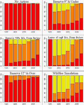
Figure 1: Risk reduction performance of
treatment alternatives for high risk stands in the ONF.
Treatments can substantially affect stand
structure and thus habitat quality. Forestry software such
as LMS can be used to predict habitat changes. Fires generally
have a more extreme impact on habitat than any other treatment.
While the No action alternative might seem to benefit some
species of wildlife, it assumes an unlikely eventuality
of no fire and produces overstocked conditions at high risk.
The habitat
Table 1: Mean net revenue
per acre from treatments on high and moderate risk forests.
| Treatment |
High cost
|
Low cost
|
| 9 & under |
($345)
|
($287)
|
| Half BA |
($265)
|
($39)
|
| 45 BA |
($169)
|
$291
|
| 12 & over |
$1,025
|
$1,953
|
impacts of the other treatments are mixed,
with some species benefiting at the expense of others. Habitat
strategies associated with fire risk reduction are inherently
local and need to be integrated with other objectives. Goshawks
may favor high-risk forests that are neither sustainable
nor characteristic of pre-settlement conditions, but their
habitat can benefit from light thinnings and from avoidance
of crown fires. The Lewis woodpecker can benefit from heavy
thinnings if the largest trees and snags are retained. The
Williamson’s sapsucker needs soft snags, making it
very susceptible to fires. Pileated woodpeckers favor multi-story
old forests, which are currently uncommon in the ONF or
FNF. Retention of large trees and snags over time would
eventually improve habitat for woodpeckers. The grizzly
bear avoids stem exclusion structures and would favor a
mix of treatments that reduces the dominance of overly dense
stands.
|
|
Analysis of the alternatives provides the opportunity to
identify better habitat strategies in concert with other
objectives and local conditions.
Carbon is stored in forest biomass but releases undesirable
emissions when fires occur. Carbon is also stored in wood
products for long periods and offsets the use of products
such as steel, aluminum and concrete that are energy intensive
(polluting) in their manufacture. When wood biomass is converted
to energy through cogeneration it displaces fossil fuels
reducing carbon emissions. The 12 inch & over treatment
produces the most merchantable log volumes and hence the
most carbon stored in products but does not reduce the fire
risk and is not sustainable. The BA 45 treatment produces
the next highest level of carbon stored in products, reduces
fire risk, and is sustainable. As carbon credit markets
are developed, they may contribute to treatment costs, paying
for otherwise unprofitable treatments. Carbon is just one
of the non-market benefits that result in positive values
from fire risk reduction strategies.
The Forest Service has generally been stymied in the process
of completing environmental reviews and arranging contracting
where costs and revenues are not directly related to positively
valued timber markets. Stewardship End Result Contracts
are being developed to allow negative revenue risk reduction
operations that provide benefits such as contract longevity
to support investments in needed infrastructure and create
economic opportunities in rural communities.
This report provides case study data on treatments that
reduce fire risk, including their costs, market values,
non-market considerations, and contracting issues. Specific
examples can be used to customize strategies for a wide
range of forest, infrastructure, and market conditions.
The information is also useful in training operators on
how to implement fuel reduction treatments. This report
demonstrates how an integrated forestry software package
can assist federal agencies and other interested users in
gaining greater efficiencies for planning fire risk reduction
treatments to achieve multiple values with fewer conflicts
and lower costs. The Landscape Management System (LMS) provides
a sophisticated, user-friendly software environment from
which professional and public users with little training
can participate in analysis of complex data to better understand
the consequences of management alternatives. The results
in this report from the case study analysis of two national
forests demonstrate that fire risk can be effectively reduced
while creating and protecting other positive environmental,
economic, and social values.
- RTI Staff -
|


RTI Director’s Notes
The focus of this newsletter is on the use of technology to
address fire issues. We have just completed a comprehensive
report on fire risk reduction strategies, which is available
on our website. This report shows the impact of a wide range
of fire risk reduction management strategies on levels of
fire risk, habitat protection, and carbon storage, as well
as log revenues. It has been known for a long time that the
cost of removing small diameter material to reduce fire risk
will many times be greater than the revenue available from
the logs in local markets. An article by Larry Mason shows
that the non-market values of fire risk reduction activities
are likely to be far greater than the costs, if all of the
values were properly reflected in the market. The non-market
values include the reduced cost of fighting fires, facility
losses, fatalities, and regeneration, as well as the value
of increased water yields, habitat saved, and more.
An article by Kevin Ceder shows how the Landscape Management
System can be used with inventory data to estimate the risk
of a crown fire before and after various thinning strategies.
Some of the impacts of alternative treatments may be surprising.
Removing only the largest trees may produce the most revenue
but it does not effectively reduce the fire risk.
|
|
Removing only the 9-inch and under
trees, as advocated by some, is not very effective at reducing
the fire risk on most stands but does result in very high
costs. Reducing the fire risk can also sequester a large amount
of carbon while saving and restoring habitat. Strategies that
produce the greatest reduction at the lowest cost while also
producing a number of non-market values are identified in
the report. Many of the environmental benefits are ignored
by the press.
Paul Lachance and Jeff Comnick extend the technology to
include the use of GIS in developing strategies for assessing
fire risk. There is also an article summarizing a recently
published study by WSU Professors Mathew Carroll and Keith
Blatner that looks at the attitudes of NIPF and tribal landowners
towards fire as both a threat to forests and a forest management
tool.
While fire fighting and fire risk issues have become commonplace
in the media, rarely will you find as comprehensive a look
at the multiple impacts that fire and fire risk reduction
strategies have on local communities.
Bruce Lippke, Director
Email: rti u.washington.edu u.washington.edu
(206) 616-3218 |
|
|


Investments in Fuel Removals
to Avoid Forest Fires Result in Substantial Benefits
As a consequence of the large, intense forest fires in
the inland west over recent years, considerable public attention
is being directed at addressing the question of how to reduce
the hazardous fuel loads from the overly dense forests that
characterize the region. Removal of the many small trees
that make up these fuel loads is known to be costly. While
large trees can be removed for lumber and other product
values as reflected in the market, the market value for
the smaller logs may be less than the harvest and hauling
charges, resulting in a net cost for thinning operations
that are needed to lower fire risk. Concerns over costs
combined with budget constraints and political debates have
resulted in limited public investments in the removal of
hazardous fuel loads. However, failure to remove these small
logs results in the retention of ladder fuels that support
the transfer of any ground fire to a crown fire with destructive
impacts to the forest landscape. Unfortunately the market
does not automatically reflect the costs of negative environmental
consequences. A recently completed cost/benefit analysis
conducted by RTI as part of a broad investigation of fire
risk reduction indicates that the negative impacts of crown
fires are underestimated and the benefits of government
investments in fuel reductions are substantial. 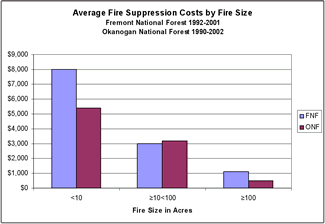
There are many market and non-market values associated with
reduction of fire risk that should be important to forest
managers and to society at large. Perhaps the most obvious
is the value of avoiding the escalating costs of fighting
fire, which nationally have been in the billions of dollars
during recent years. Similarly, there is the value of avoiding
facility losses
|
|
and fatalities that result from forest fires. Communities
value a lower fire risk and reduced smoke. Forest fires
destroy visual aesthetics and limit recreational opportunities.
The United States Congress has historically placed a very
high value on species protection as evidenced by laws such
as the Endangered Species Act or the National Forest Management
Act, yet irreplaceable habitats for threatened and endangered
species may be lost when forests burn. Valuable timber resources
are destroyed. Fires also reduce the carbon stored in the
forest and the opportunity to produce long lasting pools
of carbon stored in products. Fires consume biomass that
otherwise could be used for energy conversion and green
energy credits.
Regeneration after fires is problematic and costly, and
there may be ongoing rehabilitation investments needed to
avoid serious erosion and water contamination from excessive
sediment. If forests are thinned, water consumed by overly
dense forests could be saved for other uses such as salmon
habitat, municipal reservoirs, and agricultural irrigation.
There are also rural economic development benefits from
the taxes and rural incomes that would result from fuel
reduction activities. Since economic activity in these regions
has been in decline as a consequence of lower federal timber
harvests, any reduction in unemployment has higher than
normal leverage on state and local finances by lowering
assistance costs.
Many scientific studies have shown that forests thinned
to remove fuel loads are unlikely to experience crown fires.
Accounting for the value of this reduced risk exposure,
however, must take into consideration both the predicted
costs and the timing of future fire events. While it is
impossible to predict exactly when a future fire might occur
in a specific location, we do know that due to decades of
fire suppression, the time since last ignition in many forests
is well beyond previous fire return cycles and present fuel
loads are well above historic levels. In 2001, Powell et
al., in a Forest Service report entitled Forest Density
Management; Recent History and Trends for the Pacific Northwest
Region, estimated that 56 million acres of national forestlands
were considered at high risk of catastrophic fire, primarily
due to overcrowded trees. Fire ecologists agree that the
question is not whether these forests will burn but when.
|


(Investments in Fuel Removals to Avoid Forest
Fires Result in Substantial Benefits continued...)
|
To create an example to illustrate how the relative costs
and benefits of investments in hazardous fuels removal treatments
to reduce the risk of crown fires might be considered, we
will assume that that all acres of forests with a high risk,
if left untreated, will burn sometime in the next 30 years
while all those forests considered to be at moderate risk
will burn sometime in the next 60 years. If there is an
equal probability of each acre burning in any year during
the assigned interval, we can assume for approximation purposes
that an average time for all acres to burn is equivalent
to one half of the interval. In other words, an equal probability
that all acres burn sometime in 30 years means an average
time to burn of 15 years and correspondingly given a 60-year
interval the average burn time will be 30 years. If we further
assume, as is often done for financial analysis, that an
inflation-adjusted interest rate of 5 % is representative
of the average anticipated cost of money throughout the
risk interval then we have what we need to discount future
cost estimates to present dollars. In simpler terms this
means that every dollar that will be needed to fight forest
fires during the 30 year period for high risk represents
$0.48 of anticipated cost exposure today and for the 60
year period for moderate risk represents $0.23 today. Conversely,
investments in fuels removals today are worth the savings
represented by these present value estimates of costs avoided
if fires do not occur.
Table 1 shows present value estimates of a number of market
and non-market benefits associated with fuel removal treatments.
Also displayed for comparison are the Forest Service contract
preparation costs and operational costs of fuel removal
treatments. The treatment benefits are based on a variety
of governmental and non-governmental information sources.
The treatment cost estimates are derived from figures provided
by the Okanogan and Fremont National Forests and interviews
with harvest contractors. Treatments are assumed to be forest
thinnings within the understory that leave approximately
40-100 of the biggest trees per acre. A more rigorous explanation
of this estimation methodology and source information can
be found on the RTI web site in the “Market and Non-Market
Values” section of the recently released RTI report
entitled Investigation of Alternative Strategies for Design,
Layout, and Administration of Fuel Removal Projects. Printed
copies of this report are also available upon request.
|
|
Table 1: Estimates
of market and non-market benefits from fuel removal compared
with Forest Service treatment costs.
|
Treatment Benefits
|
Value per acre
|
| |
High Risk
|
Moderate Risk
|
| Fire fighting costs avoided |
$481
|
$231
|
| Fatalities avoided |
$8
|
$4
|
| Facility losses avoided |
$150
|
$72
|
| Timber losses avoided |
$772
|
$371
|
| Regeneration and rehabilitation costs
avoided |
$120
|
$58
|
| Community value of fire risk reduction |
$63
|
$63
|
| Increased water yield |
$83
|
$83
|
| Regional economic benefits |
$386
|
$386
|
|
Total Benefits
|
$2,063
|
$1,286
|
| |
|
Treatment costs
|
|
|
| Operational costs |
($374)
|
($374)
|
| Forest Service contract preparation costs |
($206)
|
($206)
|
| Total Costs |
($580)
|
($580)
|
| Positive Net Benefits from
Fuel Removals |
$1,483
|
$706
|
For this coarse filter cost/benefit analysis, the benefits
were intentionally estimated at the low end of their potential
while operations costs were estimated at the high end of
their potential. It is worthy to note that many areas of
the forests studied in this investigation showed positive
net returns from log sales after operations costs. It is
also worthy of note that no value was assigned to protection
of habitat even though the Congress and the Courts have
historically placed a very high value on protection of threatened
and endangered species. Even with an assumed net cost of
fuel reduction operations, however, the results of this
cost/benefit analysis show that the future risk of catastrophic
fire on the National Forests of the inland west is far costlier
to the public than investments made today to protect against
such an eventuality.
- Larry Mason, RTI -
|


Using GIS to Aid in Assessment
of Fire Risk across a Landscape
Fire is a constant threat to forests and in turn to the
objectives of forestland managers. As technology has advanced
over the past several decades so have the tools available
to forestland managers. Some of these tools can help managers
to assess the extent that their forestlands are at risk
if a fire were to occur and to decide what management actions
may be appropriate in attempting to reduce risk. With a
better understanding of the distribution of risk across
a landscape, plans can be designed to systematically alter
the risk to that landscape as a whole.
Geographic Information Systems (GIS) can be used to construct
a representation of a real world landscape. Figure 1 is
a representation of the present day fire risk for a watershed
in the Colville National Forest. To assign individual stands
to a risk class, tree-level inventory data was analyzed
using the Fire and Fuels Extension (FFE) to the Forest Vegetation
Simulator developed by the US Forest Service. Among the
outputs of FFE is the wind speed needed to sustain a crowning
fire. If the required wind speed is less than 25 miles per
hour (mph), the stand is classified as high risk (represented
in Figure 1 by the darkest coloring).
Similarly, moderate stands need a wind speed between 25
and 50 mph to sustain a crowning fire (displayed in grey).
The lightly shaded stands are low risk, requiring a wind
speed greater than 50 mph according to FFE.
The utility of GIS does not end with its mapmaking abilities.
Once stand polygons have been classified by fire risk, more
complex spatial analyses can be performed. Layers can be
developed for objectives such as habitat or stand structure
to analyze the impact of treatments relative to multiple
objectives. If fire risk is the primary concern of the forestland
managers, then the spatial display of the risk classifications
can be very useful in prioritizing management actions.
|
|
The significance of being able to display fire risk data
in this way is that managers can plan treatments that have
a large impact on the landscape while only altering select
stands. This can be accomplished by identifying a group
of stands that have a high fire risk classification under
current conditions and are in close proximity to each other.
In a group that has such Using a GIS representation of the
landscape, such groups could be identified and the interior
stands could be selected for the initial treatment to effectively
fracture these high risk blocks. Through this and other
techniques, GIS can be used as a tool to help forestland
managers reduce fire risk more effectively and efficiently
across a landscape.
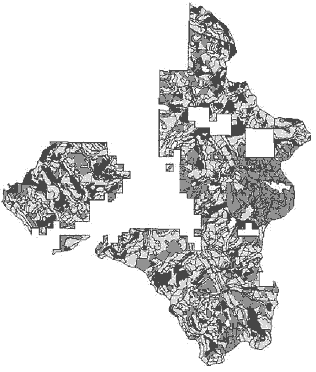
Figure 1: Present fire risk for a watershed
in the Colville National Forest
- Paul LaChance & Jeff Comnick, RTI
-
|


Fire Modeling Developments
Provide User-Friendly Risk Analysis
Modeling and analysis of forest fire risks associated with
present conditions and future management alternatives can
now be done easily in the Landscape Management System (LMS)
with the release of the LMS-FFE Add-On. The components of
this add-on include the Fire Scoping Report, all variants
of the Fire and Fuels Extension (FFE) for the Forest Vegetation
Simulator (FVS), the LMS-FFE Configuration Tool, and LMS
tables linked to FFE-FVS outputs.
FFE is a fire effects model developed by the US Forest
Service for use with the FVS growth model. Variants of FFE-FVS
are available for the majority of the fire-adapted ecosystems
of the western US including the Eastern Cascades, Inland
Empire, Rocky Mountains, Sierras, and Siskiyous. All FFE-FVS
variants are installed by the LMS-FFE Add-On, which is available
for free download from the LMS web site.
The Fire Scoping Report included with the add-on provides
fire risk analysis on a multiple-stand or landscape level.
This series of tables and graphs summarizes fire risk relative
to various forest attributes such as elevation, stand density
(TPA), quadratic mean diameter (QMD), basal area (BA), dominant
species, Reineke’s stand density index (SDI), and canopy
layers. Fire risk is classified based on crowning index,
which is the potential wind speed at 20-feet above the ground
needed to initialize and carry a crown fire in a
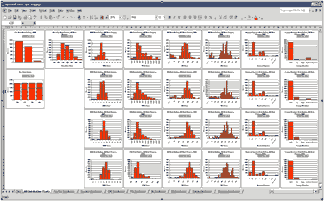
Figure 1: LMS FVS-FFE graphical out puts
provide ready access to stand attributes of interest.
stand. High risk stands have a crowning index value of
25 miles per hour (mph) or less. Moderate stands have a
crowning index of 25 – 50 mph. Low risk stands have
a crowning index value of 50 mph or more.
|
|
Graphical summarization of stand attributes based on risk
class in the Fire Scoping Report are useful to see how trends
of risk are influenced by dominant species, canopy structure,
stand density, and elevation (Figure 1).
Configuring LMS to run FFE-FVS is done with the LMS-FFE
Configuration Tool (Figure 2). With this tool, features
of the LMS-FFE Add-On such as potential fire reports, fire
simulations, and simulated fire visualization images can
all be set-up in a user-friendly dialogue box. When any
of these features are enabled, default values from the selected
variant of FFE-FVS are automatically entered. However, any
of these values can be altered by the user to tailor behavior
of FFE-FVS to better fit local conditions.
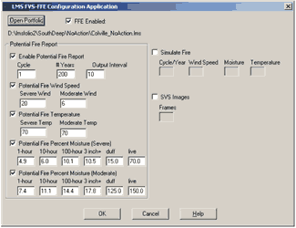
Figure 2: LMS FVS-FFE dialogue box. User
can define modeling parameters or use model defaults.
Additional links are added to LMS by the LMS-FFE Add-On
that provide access to three FFE output tables: Potential
Fire Report, Consumption and Physical Effects Report, and
All Fuels Report. These tables allow users to answer questions
regarding fire behavior, fuel loading, smoke emissions,
mortality, and biomass consumption and associated carbon
release from either a simulated fire or a potential fire.
- Kevin Ceder, RTI -
For additional information regarding the LMS-FFE Add-On
contact:
Kevin Ceder at thuja u.washington.edu u.washington.edu
or
Jim McCarter at jmac u.washington.edu. u.washington.edu.
Additional information regarding FFE-FVS can be found at
the LMS
web site.
|


NIPF and Tribal Attitudes About
Fire and Forest Management
A recent WSU study looks at the attitudes of non-industrial
private forest (NIPF) landowners and tribal forest landowners
in northeastern Washington towards fire and forest management.
While much public attention and debate has focused on the
role of fire as a natural process, a threat, and a management
tool on public forest lands, less attention hasbeen focused
on fire in other forest land ownership categories. The primary
purpose of this study was to developa better understanding
of the role played by fire both as a potential threat and
a potential tool in the management strategies of non-public
forest landholders in two Washington counties: Okanogan
County in north central Washington and Stevens County in
northeastern Washington.
The study was done by conducting interviews with a number
of NIPF and tribal landowners in each county. Each landowner
category was analyzed, focusing on management objectives,
perception of fire as a threat, and interest in prescribed
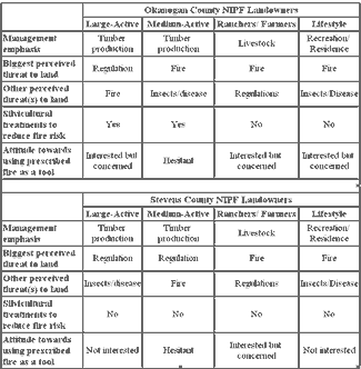
burning. Of the NIPF landowners interviewed, four generally
distinct categories were identified: large-active mangers
(typically owning more than 400 acres); medium-active managers
(20-400 acres); farmers/ranchers; and lifestyle landowners
(5-200 acres). The results for these categories are summarized
in Table 1. In addition, tribal lands constitute a class
of land holding consisting of two categories: tribal lands
held in common and individual tribal allotments controlled
by families.
Large-active landowners were those with larger land holdings
(400 to 3,000 acres) who managed relatively intensely. The
primary management objective in this category was timber
production, with timber being an important source of income
for this group. For both counties, the landowners in this
group did not see fire as the biggest threat to their land,
but rather forest
|
|
practice regulations. In Okanogan County, fire was seen
as the next biggest threat, while in Stevens County, insects
and disease were seen as the next biggest threat.
The large-active landowners in Okanogan County used silvicultural
practices (thinning and pruning) to reduce fire hazard as
well as to improve tree growth. In contrast, Stevens County
large-actives did not see fire as an immediate or highly
likely threat, due in part to different moisture levels
and fires histories.
Table 1: Summary of results for four
NIPF landowner categories.
Thus, while these landowners saw timber stand improvement
treatments as also beneficial for reducing fire risk, treatments
solely to reduce fire risk were considered too costly and
not likely to reduce risk effectively. There was not much
interest among Stevens County large-actives for using prescribed
burning as a tool. There was interest in Okanogan County,
but not without concerns about the potential for escaped
fires and the resulting liability. Medium-active landowners
also emphasized timber production,
|


(NIPF and Tribal Attitudes About Fire and Forest
Management continued...)
|
with ownerships ranging from 20 to 400 acres. Medium-actives
in Stevens County saw regulations as the biggest land threat,
followed by fire. In Okanogan County, fire was seen as the
biggest threat, followed by insects and disease. While medium-active
landowners commonly did silvicultural treatments to reduce
fire risk in Okanogan County, silviculture in Stevens County
was oriented towards improving tree growth, with fire risk
reduction as only a side benefit. Medium-active landowners
in both counties hesitated using prescribed burning as a
management tool due to concerns about the liability of escaped
fires and practical considerations given their small parcel
sizes.
Landowners in the ranchers and farmers group manage land
primarily for livestock production. In terms of forest management,
this group could be further divided into two sub-categories:
active managers and non-active managers. In both counties,
ranchers listed fire as the biggest threat to their land.
Especially active managers also frequently mentioned regulations.
Despite concerns by this group about the threat of fire,
most ranchers in Stevens County had not done anything specific
to address fire risk. Active managers believed that timber
stand improvement treatments and the presence of grazing
and irrigation had already reduced risk on their property,
while the less active managers saw fire as a natural process,
that one could not do much about. Active landowners in this
group saw prescribed burning as a good management tool,
but they had the same liability concerns as landowners in
other groups.
Lifestyle landowners are those who purchased their land
for recreational or residential use with parcel sizes ranging
from 5 to 200 acres. Lifestyle landowners in both counties
saw fire as the biggest threat to their land, with insects
and disease also seen as a threat. There was no interest
in the use of prescribed fire
|
|
among lifestyle landowners in Stevens County. Those in
Okanogan County were more familiar with prescribed burning
and there was some interest in using it.
Two categories were considered for reservation landholders:
trust lands held in common (tribal lands), and trust lands
held by native families as allotments. The present-day objectives
for tribal forest management include income production but
also the long-term sustainability of a variety of forest
resources. In terms of threats to forests, tribal forest
managers tended to emphasize insects, disease, and overstocking,
with stand-replacing fires also seen as a threat. Interestingly,
allotment holders and tribal members generally talked about
insects, disease, and wildfire as threats, but also emphasized
the lack of periodic fire as a threat, particularly with
respect to wildlife habitat and the increased risk of catastrophic
fire.
Overall, the threat of wildfire does not appear to be the
primary factor affecting forest management decisions for
many landowners. Economic objectives are often more immediately
pressing. There are a number of barriers to the use of prescribed
burning as a management tool, especially on NIPF lands.
The biggest of these barriers is the liability of escaped
fires. Changes in liability laws would be needed to overcome
this barrier. Other barriers include the expense, lack of
expertise, practicality given small parcel sizes, narrow
burn windows, and smoke issues. If there is a single “take-home”
message from this study, it is that “one size does
not fit all” either in terms of the extent to which
wildfire is important in influencing management decisions
or in the possibilities of using fire more extensively as
a forest management tool.
- Matt Carroll, Keith Blatner, Patricia
Cohn, Depart. of Natural Resource Sciences, WSU -
|


Workshop
Announcement
RTI, in collaboration with CFR-CINTRAFOR, WSU Extension,
and the Western Forestry & Conservation Association,
is offering a one-day workshop titled:
Innovation for Survival of the NW Forest
Sector: An Integrated Approach
This workshop will focus on innovations in products, management,
log marketing, and policy and will be held at the WSU-Puyallup
campus on November 18, 2003.
For additional program and registration information, contact
Don Hanley, WSU Extension Forester,
at dhanley u.washington.edu
or call 206-685-4960. u.washington.edu
or call 206-685-4960.
|


Readers may send comments to:
Bruce Lippke, Director RTI
CFR, University of Washington
Box 352100
Seattle, WA 98195-2100
Phone: 206-616-3218
email: RTI u.washington.edu u.washington.edu
Janean Creighton, Editor RTI News
Department of Natural Resource Sciences
Washington State University
PO Box 646410
Pullman, WA 99164-6410
Phone: 509-335-2877
email: creighton wsu.edu wsu.edu
|
|
|


