|
Summer 2003, Volume 3, No. 2
|
Table of Contents:
|
|
Alternate plans: Developing templates for Eastern Washington
An important element of Washington’s Forests and Fish Rules
(FFR) is a provision giving landowners flexibility to create
alternate management plans in cases where riparian function
can be met in a more cost-effective manner. However the alternate
plan process can be complicated and difficult. To simplify alternate
plans, the FFR call for the development of management templates
(WAC 222-12-0403). |
|
MPB. However, there is also the additional retention requirement
of 50 TPA, including the 21 largest trees. If these leave
trees have a quadratic mean diameter (QMD) that approaches
18” diameter at breast height (DBH) then the post-harvest
BA/acre is high enough that a risk of a MPB outbreak remains.
For example, Figure 1 shows the post-harvest BA distribution
in the inner zone under the FFR for several Eastside riparian
stands taken from RTI case studies (Oneil 2003). In this figure,
BA is broken down into its components: TPA and QMD (the diameter
of the tree of average BA), and it is plotted relative to
the BA threshold for risk of MPB outbreak. Under the FFR,
75% of these case study inventories remain above the MPB risk
threshold after harvest.
FFR provisions for alternate plans provide an opportunity
to develop a management template that would meet riparian
function, reduce the risk of MPB outbreak, and provide a better
economic return to the
|
|
While a lot of attention has been focused on template development
for Westside conditions, alternate plan templates are also
needed on the Eastside. The FFR have been shown to have significant
economic impacts for some Eastside landowners (RTI
Fact Sheet #20), and the Forestry Riparian Easement Program
is not adequately funded to provide large-scale economic relief.
Alternate plans are a necessary mechanism for helping forest
landowners to maintain their economic viability while responding
to Eastside management challenges such as forest health.
Forest health issues are a common situation on the Eastside
where drought and overstocked conditions result in stressed
forests. A serious Eastside forest health issue is the risk
of mountain pine beetle (MPB) outbreaks. Healthy forests are
able to repel MPB attacks. However when stressed trees do
not have adequate vigor to repel a MPB attack, an outbreak
occurs causing widespread mortality. Depending upon site quality,
stocking density, and weather, forests can become susceptible
to MPB outbreaks when they accumulate 80 to 100 ft2
of basal area (BA) per acre (Cochran 1988, Larsson et al.1983,
Schmid and Mata 1992, Cochran et al. 1994).
Under the FFR, the inner portion of the riparian zone on
low elevation sites cannot be harvested until BA reaches 110
ft2/acre, which is above the threshold for a MPB
attack. Once a stand meets this requirement, a harvest can
be done in the inner zone as long as a minimum of 60 ft2
of BA/acre is retained. By itself, the retention requirement
of 60 ft2 of BA/acre would leave post-harvest stands
below the risk threshold for
|
|
landowner. One of the challenges, however, will be to assess
whether or not an alternate plan meets the requirement of
providing protection “at least equal in overall effectiveness”
as the FFR (WAC 222-12-040). A possible approach is to look
at the results of an alternate plan relative to the overall
intent of the rules.
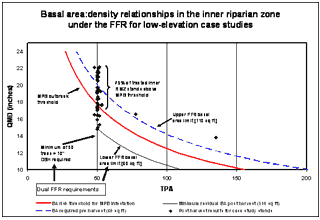
| Figure 1: Basal area distribution
post harvest for inner riparian zones in low elevation
case study sites under the FFR. |
In Eastern Washington the FFR were “designed to mimic
Eastside disturbance regimes within a range that meets functional
conditions and maintains general forest health” (WAC
222-30-022). An alternate plan that reduces BA below the risk
threshold of MPB outbreak will help to maintain “general
forest health.” However, the plan must still meet “functional
conditions.” A possible solution is to use a measure
of relative stand density, such as stand density index (SDI),
to create an easy to use look-up table that links the FFR
target of 50 TPA and 60 ft2 of BA/acre to variable
TPA and QMD targets that provide maximum riparian function,
|


| while keeping BA lower than the
MPB threshold of 80 ft2/acre. SDI creates a useful
reference based upon how many 10” trees would be relatively
as dense as a stand of interest (Reineke 1933, Long and Daniel
1990). The minimum post-harvest retention required in the
inner zone under the FFR is 50 TPA and 60 ft2 of
BA/acre, which equals an SDI of 95 (i.e. it is relatively
as dense as 95 10” trees).
Table 1 shows incremental combinations of TPA and QMD that
equal an SDI of 95, as well as the resultant BA for each
combination. An alternate plan template based upon equivalent
SDI would allow the number of leave trees to be selected
based on their size such that the desired SDI and BA are
both achieved. A template of this sort would allow landowners
to create a management prescription based on easily measurable
stand variables (QMD and TPA) that achieves an SDI equivalent
to the rule requirements while lowering the risk of a MPB
attack.
| SDI |
TPA |
QMD |
BA |
|
95
|
95
|
10
|
52
|
|
95
|
82
|
11
|
54
|
|
95
|
71
|
12
|
56
|
|
95
|
62
|
13
|
58
|
|
95
|
55
|
14
|
59
|
|
95
|
50
|
14.9
|
60
|
|
95
|
50
|
15
|
61
|
|
95
|
45
|
16
|
63
|
|
95
|
41
|
17
|
64
|
|
95
|
37
|
18
|
66
|
|
95
|
34
|
19
|
67
|
|
95
|
31
|
20
|
68
|
|
95
|
29
|
21
|
70
|
|
95
|
27
|
22
|
71
|
|
95
|
25
|
23
|
72
|
|
95
|
23
|
24
|
74
|
|
For demonstration purposes, comparative
growth and harvest simulations have been created for
a case study forest in Okanogan County that is experiencing
mortality from MPB. Simulations include an example alternate
plan, management under FFR no alternate plan, and no
management. Under the sample alternate plan, an inner
zone harvest was done that retained an SDI of 95 and
approximately 50-60 ft2 of BA/acre. |
Retention included 50 TPA greater than 10” in DBH, but
this did not include the 21 largest trees. This |
|
flexibility in selecting leave
trees allowed an SDI of 95 to be achieved with a basal area
that is below the risk threshold for MPB. The alternate plan
also provided a greater economic return, yielding an improved
net present value for this forest of $279/acre versus $228/acre
under the FFR.
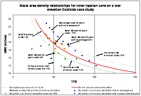
Results presented in Figure 2 indicate that the mean BA/acre
over 90 years under the FFR inner zone prescription is on
the isoline where mortality from MPB outbreak can be expected.
Under a no management scenario, which the FFR require in
the core zone, the mean BA/acre is well above the MPB isoline,
indicating high risk. In contrast, the example alternate
plan maintains an average BA below the MPB risk level in
all decades.
| Figure 2: Basal area
relationships under the FFR and an example alternate
plan for an Eastside case study. |
Alternate plan templates for Eastern Washington are necessary
to address both economic and forest health concerns. Creating
templates is challenging, but with the use of a relative
density measure like SDI, easy to use look up tables can
be constructed to guide development of alternate plans that
meet riparian function, improve forest health, and provide
economic relief to landowners.
- Elaine Oneil, RTI Graduate Student -
|
RTI Director’s Notes
We have been investigating the potential for alternate plans
that can support viable economics as the key to sustainable
forest management while providing no less protection for salmon
than is provided by the new riparian management regulations.
While it is unfortunate that a proper economic analysis and
assessment of the impact of the rules is rather technical
and expensive, the opportunity to develop templates that simplify
the approval of and management under alternative plans is
promising.
Previous RTI newsletters have provided analysis of case
studies which show substantial economic losses for some
family forest owners from the Forest and Fish Rules (FFR)
while also reducing the opportunity to thin overly dense
stands, foregoing the opportunity to put many of these stands
on a pathway to reach the desired conditions sought by the
regulations. In this issue we feature two articles that
provide status reports on what it takes to develop alternative
plans and ultimately templates: one which is focused on
the Westside and the common problem of overstocked managed
stands, and one which is focused on the Eastside and the
common problem of avoiding insect infestation. The results
indicate that alternate plans can be developed to restore
viable economics and protect habitat at least as well as
the regulation. The Legislature anticipated most of the
problems that we have articulated, and they have made provisions
for alternative plans and templates as the solution. The
process of getting them accepted and implemented in a reasonable
amount of time and effort is the challenge.
|
|
The opportunity for hardwood or
mixed species riparian buffers that could be more sustainable
(i.e. offer better economics and more protection on agriculture
lands) seemed promising to our board a year ago and we are
happy to report that an RTI feasibility project has lead to
a successful SARE (Sustainable Agriculture Research and Education)
grant of $242,000 awarded to WSU Professors Jim Drobrowolski
and Jon Johnson to develop a scale demonstration and evaluation
project with the full support of a number of landowners and
agricultural interests.
On the educational front, RTI and Pack Forest staff have
established a demonstration of riparian buffer alternatives
at the UW Pack Experimental Forest near Eatonville that
has helped family forest owners, foresters, and the public
to better understand the regulatory requirements and the
impact of management alternatives. A comparable demonstration
site for Eastern Washington has been developed by Peter
Griessmann, WSU Extension, at the Sherwood Creek Demonstration
Forest in Northeast Washington.
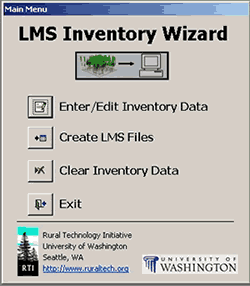
In response to a request from a number of users, we also
report the release of our new “Inventory Wizard”
software tool developed by Kevin Zobrist to make inventory
data easily importable into the Landscape Management System
(LMS). LMS is being more widely used for developing management
plans as it provides so many different outputs of importance
when managing for multiple objectives.
Bruce Lippke, Director
Email: rti u.washington.edu u.washington.edu
(206) 616-3218 |
|
|
| Red Alder Seedlings Available
from the WA DNR Webster Nursery
Phone: 360-664-0963
E-mail: websterwadnr.gov
Website: http://www.dnr.wa.gov
- Twin Harbors seed source
- 0-1000 elevation
- P-1/2 (half year in the greenhouse and half year in
the bareroot fields)
- $300/M
- Average height will be about 2 feet tall
- 47,000 available
- Orders accepted after September 2, 2003 on a first come,
first serve basis
- Stock can be picked up after December 8, 2003,depending
on weather
|
Let’s Stay in Touch!
Let us know if:
- There is an error in your name and address
- Your address has changed
- You or your family are recieving multiple copies and
only need one
- You wish to be removed from this mailing list
| Please contact: |
Kevin Zobrist
Box 352100
Seattle, WA 98195-2100
(206) 543-0827
kzobru.washington.edu |
|
An integrated process for developing alternate plan templates
for overstocked stands
RTI has been working to develop an objective, scientific process
for developing alternate plan templates. There has been increasing
interest in the creation of these templates to facilitate
the development of alternate riparian management plans for
family forest owners in Washington. The purpose of alternate
plans is to “meet riparian functions while requiring
less costly regulatory prescriptions” (RCW 76.113.110).
Developing less costly prescriptions is important, as RTI
case studies indicate that many family forest owners will
have significant economic losses given the management options
available under the FFR (see RTI Fact
Sheets #2 and #20).
While a funded Forestry Riparian Easement Program has the
ability to help some of these landowners, it leaves out many
others who will need less costly alternatives in order to
remain economically viable.
It is important that family forests in Washington remain
economically viable. Family forests are located in the lowland
areas where there is a lot of critical riparian habitat
. They also interface with urban and suburban areas, providing
a buffer between areas of urban sprawl and the industrial
forests and public lands further upslope. Coupled with the
strong stewardship ethic found in family forestry, these
factors put family forests in a unique position to provide
for quality riparian habitat and a multitude of other public
values. However, these factors also make family forests
particularly sensitive to conversion pressures. Family forestland
in Washington is converted at significant rates as urban
areas rapidly expand. This conversion rate will be exacerbated
if forest management options are no longer economically
viable for these landowners.
A streamlined process for the development and approval
of alternate plans is necessary to facilitate the large
number of landowners who could benefit from an alternate
plan. The Forest Practices Rules provide for the creation
of template prescriptions to simplify the development of
alternate plans for common situations (WAC 222-12-0403).
A common situation in Western Washington that is a good
candidate for such
|
|
a template is an overstocked stand. Douglas-fir plantations
are planted at high densities to maximize early growth with
the expectation that the density will be reduced through
subsequent thinning operations. In riparian areas, these
subsequent thinnings are not always possible or economical
under the options specified in the FFR. This is an economic
setback for landowners, and it also leaves these areas in
an unnatural and overly dense condition that inhibits stand
development. An alternate plan template to address these
situations would provide an opportunity for both economic
relief and riparian habitat improvement.
The first step in developing an alternate plan template
is to generate a range of creative management alternatives
to address both riparian habitat and economic needs. For
overstocked stands, these alternatives should include different
thinning strategies throughout the riparian zone. To demonstrate
this, we created 10 example alternatives and used the Landscape
Management System (LMS) to simulate them over time on a
sample inventory from a 20-year-old Douglas-fir plantation
on site class II that is stocked at 450-500 trees per acre
(TPA). Each of the example alternatives included a 25-foot
“bank stability zone,” which is most critical
for shade and large woody debris (LWD) recruitment. Depending
on the prescription, this zone was either thinned successively
to 60 TPA, thinned successively to 25 TPA, or left untouched.
Adjacent to the core zone was an additional riparian management
area that extended out to 50, 80, or 113 feet. This area
was either thinned successively to 25 TPA and then left
alone, or it was managed on a 100-year rotation with multiple
thinnings.
Once a series of potential management alternatives has
been simulated, the adequacy of each alternative must be
assessed. The rules require alternate plans to “provide
protection for public resources at least equal in overall
effectiveness to the protection provided in [the FFR]”
(WAC 222-12-0401). One of the biggest challenges in creating
viable alternatives is establishing specific criteria that
can be used to objectively assess whether or not a prospective
template prescription provides the necessary level of resource
protection. For westside streams, the FFR have established
a riparian protection and restoration paradigm known as
the Desired Future Conditions (DFC). The DFC
|
|
represent mature forest structure, and they are based
on a sample of 80 to 300-year-old unmanaged riparian stands
known as the DFC dataset. The goal of the management options
specified in the FFR is to achieve basal area values at
age 140 that exceed the targets established by this dataset.
Working within this paradigm, RTI has expanded on the DFC
approach and created a statistically rigorous assessment
procedure that can be used to evaluate potential alternate
plans. This procedure addresses multiple parameters (such
as stand density, mean diameter, and average height) simultaneously
to better discriminate between desirable and undesirable
forest structures, and it directly accounts for natural
forest variability. The procedure establishes a DFC acceptability
range given a desired acceptance level. Potential alternatives
can be evaluated over time to see what percent of the time
the resulting forest structure falls within this acceptability
range.
The next step is to combine this assessment with economic
analysis to assess whether or not a potential alternative
is economically viable. The long-term economic potential
of sustainable forest management may be the most important
measure of economic viability, as it is most closely related
to the motivation to maintain the land as forestland rather
than converting to other uses.
This can be evaluated by calculating the land expectation
value (LEV) per riparian acre for each alternative at an
appropriate target rate of return.
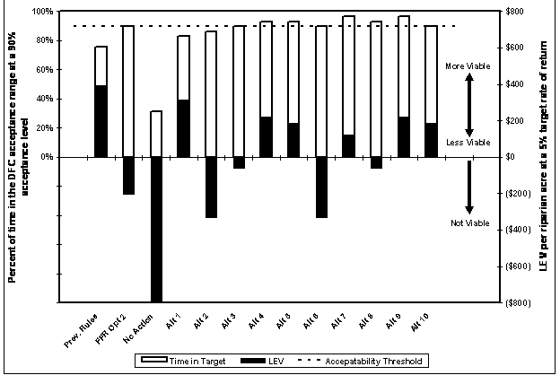
Figure 1 compares the ten example alternatives with three
reference scenarios in terms of the percentage time in the
DFC acceptance range at a 90% acceptance level and LEV per
riparian acre at a 5% real rate of return. The three reference
scenarios include no action, FFR Option 2, and management
under the previous rules. Figure 1 can be used to identify
which alternatives are good candidates for an alternate
plan template. Of our ten example alternatives, alternatives
3-10 fall within the DFC
|
|
acceptance range at least as much as FFR Option 2. Of
that subset, 4, 5, 7, 9, and 10 are judged to be economically
viable for sustained management. A template prescription
based on these five alternatives would meet DFC goals while
maintaining economic viability.
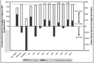
| Figure 1: Comparison
of DFC acceptability and economic performance between
the previous rules, FFR Option 2, no action, and ten
example alternatives. Alternatives that meet the acceptability
threshold (based on FFR Option 2) while maintaining
a viable LEV should be identified as potential template
prescriptions. |
Alternate plan templates will be an important tool in enabling
family forest owners to protect aquatic resources while
keeping sustainable forestry economically viable in the
long term. It is challenging to create template prescriptions
that fulfill the legislative goals of meeting riparian functions
while minimizing the cost to landowners. The process above
provides an objective, science-based procedure to both develop
and assess potential prescriptions. Our example analysis
suggests that by using the process above it is indeed possible
to develop prescriptions that meet challenging and often
conflicting criteria. This process can be employed not only
for overstocked stands, but for any common situation that
could benefit from a template.
|
New tool helps foresters and landowners import their forest
data into LMS
An important part of RTI’s mission is to put new technological
tools in the hands of foresters and forest landowners to
aid complex forest management decisions. One of our most
effective tools is the Landscape Management System (LMS).
We have received a very positive response to the numerous
LMS trainings that have been offered throughout Washington,
and the worldwide user base has continued to grow.
Development of the LMS program continues at
a rapid pace as we work to make it even more powerful and
easier to use. We have received several feedback comments
regarding the difficulty that many new users have in importing
their own forest data into the program. Building the necessary
LMS inventory files can indeed be challenging, and in response
to this feedback we have developed the LMS Inventory Wizard
to greatly simplify this process and eliminate many common
file errors.
The data entry window of the LMS Inventory
Wizard resembles an electronic plot card. Users first enter
stand level data, then individual tree records can be entered
for each plot. Tree species can be selected from a drop-down
list of common names, eliminating
|
|
the need to know species codes. Helpful tips display in
the bottom of the screen to guide users as they enter data
and explain the requirements for each field. Given the plot
size or basal area factor, the Inventory Wizard automatically
computes expansion factors based on the total number of
plots entered for a given stand. Fields for both variable
and fixed plots and subplots accommodate virtually any sampling
design from simple to complex.
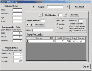
Inventory data can be entered for just one stand or for
many different stands on an ownership. Once all the inventory
data have been entered, the inventory wizard automatically
generates the files necessary for importing into LMS. A
complete tutorial guides users through the entire process,
from entering data to generating files to importing into
LMS and opening the new portfolio for the first time.
Both the LMS Inventory Wizard and its tutorial are available
for free download from http://lms.cfr.washington.edu/lmsinvwizard.shtml.
It can also be found by looking under “Tools”
on the RTI website. One potential limitation of the Inventory
Wizard is that it requires Microsoft Access to run. If you
are interested in this tool but do not have Access installed
on your PC, please let us know so that we can assess the
need for a stand-alone version. We also welcome any other
comments or questions about this tool. Please direct all
feedback to kzobru.washington.edu
or call us at (206) 543-0827.
- Kevin Zobrist, RTI Economist -
|
Riparian Buffer Demonstrations at Pack and Sherwood Creek
Forests
The Forests and Fish Rules have significantly changed the
way riparian zones are managed on private lands in Washington.
There are several riparian harvest options under the new
rules, and RTI case studies have shown that selecting the
appropriate option is an important decision facing landowners.
To better familiarize landowners with these options, riparian
buffer demonstration sites have been established for both
Western Washington and Eastern Washington.
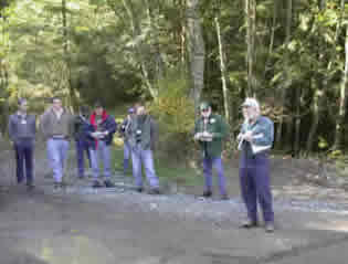 RTI’s Larry Mason leads a tour group
through the riparian demonstration site at Pack Forest
RTI’s Larry Mason leads a tour group
through the riparian demonstration site at Pack Forest
On the westside, the University of Washington’s Pack
Experimental Forest has established a demonstration site
that shows what the on-the-ground implementation of each
westside buffer option looks like. An interpretive trail
leads visitors through different harvested segments of a
riparian zone that demonstrate option 1, option 2, a full-width
buffer, and the previous rules. Colored stakes mark the
boundary of each
|
|
buffer zone (core, inner, and outer) to give visitors an
idea of the relative width of each zone. This site and others
at Pack Forest are open to the public.
In Eastern Washington, the Sherwood Creek Demonstration
Forest, a privately owned forest located near Chewelah,
WA, was established as an upland management demonstration
area in the year 2000. The area is a great hands-on outdoor
learning environment for the public. This year a forested
riparian demonstration area will be added to show varying
stream harvesting and core zone “no entry” areas.
Informational signs and guided tours provide landowners
with valuable eastside streamside management information.
This riparian area offers unique and one-of-a-kind views
of a disturbed system.
To arrange a group tour at Pack Forest, please
contact RTI at (206) 543-0827. For individual, self-guided
tours, or for information about other demonstration sites
and public hiking trails available at Pack Forest, please
call Pack Forest at 360-832-6534 (206-685-4485 from Seattle),
or visit them online at www.packforest.org.
Information on the Sherwood Creek Demonstration Forest
can be obtained by contacting Peter Griessmann at 509-684-2588
or
by email at pgriessmwsu.edu.
- Kevin Zobrist, RTI Economist
Peter Griessman, WSU
Extension Forester - |
 |
|
Newly Released RTI Report Shows Thinning Can Reduce
Forest Fire Risk and Create Economic Opportunities for
Depressed Rural Communities
“Investigation of Alternative Strategies for Design,
Layout and Administration of Fuel Removal Projects”details
the results of a two-year study undertaken by RTI, to examine
how the use of emerging forestry software technologies combined
with existing knowledge provides new opportunities to more
effectively reduce fire risk through removal of hazardous
fuel loads. An electronic version of this report is available
at www.ruraltech.org . Printed copies are available upon
request.
Report Highlights:
-
Approximately 2/3 of forested acreage
in the Fremont and Okanogan National Forests is at moderate
to high risk of crowning forest fire.
-
These forests average more than 1000
trees per acre and the majority of the trees are in
small diameter classes that contribute to historically
unprecedented ladder fuel loads.
-
Computer generated thinning simulations
show that harvests of smaller trees with retention of
larger trees can substantively reduce risk of catastrophic
wildfire while protecting habitats, reducing releases
of harmful carbon to the atmosphere, creating economic
development opportunities for rural communities, and
reducing fire fighting costs, fatalities, and lost facilities.
-
The non-market values produced by fire
risk reduction activities are substantially greater
than the costs of fuel reduction.
-
Modeling technologies, if delivered
in user-friendly formats, can provide powerful tools
to develop scientifically credible and politically acceptable
fuel reduction projects for the public forestlands of
the intermountain west.
|
|
RTI to Co-sponsor International Symposium in 2004
Human Dimensions of Family and Farm Forestry International
Symposium will be held March 29 - April 1, 2004 at Washington
State University, in collaboration with IUFRO (International
Union of Forest Research Organizations) Research Group 3.08.00:
Small Scale Forestry. The objective of this symposium is
to bring together scientists and practitioners from all
corners of the world to discuss research problems, results,
and practical applications related to human dimensions of
family, farm, small-scale, nonindustrial private, and community
forestry. The symposium will have oral and poster presentations.
RTI is a co-sponsor.
For more information, please visit the website at: www.familyforestrysymposium.wsu.edu
or send an email to: familyforestrywsu.edu

|
Upcoming Events
|
|
September
|
|
November
|
Watershed Restoration: Rehabilitations and Recovery
of Disturbed Watersheds
9/22 - 9/26 2003
Wenatchee,
WA |
Forest Stewardship Coached Planning
Shortcourses:
Forestry Agent:
| Peter Griessmann: |
|
9/9
- 10/14
Tuesday
evenings
|
Spokane, WA |
9/10
- 10/15
Wednesday
evenings
|
Usk, WA |
9/11
- 10/16
Thursday
evenings |
Colville, WA |
| Mike Nystrom: |
|
9/16
- 11/4
Tuesday
evenings |
Puyallup, WA |
| Steve Sax |
|
9/17
- 11/19
Wednesday
evenings |
Maple Valley, WA |
|
|
|
GIS Training Workshop
11/3 - 11/5 2003
Colville,
WA |
Forestry education for logging professionals (Current
concepts of forest ecology, silviculture, and forest
management)
11/20 2003 TBA
|
Landscape Management System Training Course
12/10 - 12/12
2003 Spokane,
WA |
Forest Health Update
12/6 2003 Colville,
WA |
For information on the Landscape Management System training
course, visit the RTI website at http://www.ruraltech.org/training
or call (206) 543-0827.
|
| |
|
|
|
October
|
|
|
Fall Forestry Educational Seminar (Forestry education
for natural resource professionals who work with private
forest landowners) October 25th, 2003.
Pack Forest
Eatonville,
WA |
|
|
For all other events,
visit the website: http://ext.nrs.wsu.edu/newsevents/index.htm
or call the Washington State University Cooperative Extension
office at 509-335-2963. |
Readers may send comments to:
Bruce Lippke, Director RTI
CFR, University of Washington
Box 352100
Seattle, WA 98195-2100
Phone: 206-616-3218
email: RTIu.washington.edu
Janean Creighton, Editor RTI News
Department of Natural Resource Sciences
Washington State University
PO Box 646410
Pullman, WA 99164-6410
Phone: 509-335-2877
email: creightonwsu.edu
|
|