The Rural Technology Initiative ceased operations in 2011. This site is maintained as an archive of works from RTI collaborators from 2000 to 2011 and is no longer updated. RTI's successor and remaining staff can be found at NRSIG.org


Search the RTI Website
 
Click to go to the Precision Forestry Cooperative website
Click to go to the RTI Home page
Click to go to the About RTI page
Click to go to the RTI Projects page
Click to go to the RTI Publications page
Click to go to the RTI Tools page
Click to go to the RTI Geographic Information Systems page
Click to go to the RTI Streaming Video Directory
Click to go to the RTI Training page
Click to go to the RTI Contacts page
Click to go to the RTI Image Archive
Click to go to the RTI Site Map
Click to go to the RTI Links page


Spring 2002, Vol. 2, No. 2

Table of Contents:

Director's Notes: by Bruce Lippke

Alternate Plans: Needs and Challenges: by Kevin Zobrist and Elain Oneil

Measuring the Effect of Management on Shade Production and Large Woody Debris Recruitment Potential: by Jason Cross

Defining Riparian Zone Targets for Alternative Plans: by Kevin R. Gehringer


Director’s Notes

Prior newsletters have reported on our case studies that have evaluated the economic impact of the Forest and Fish regulations on small, non-industrial owners. An in-depth analysis is available on our website at www.ruraltech.org or available as a paper on request. One interpretation from the case studies would be that unless better alternatives can be found, many small owners will absorb substantial economic losses, and the rate of conversion of forestland to other uses will increase. Trying to find better alternatives is as important to the regulatory process as it is to the small owners.This newsletter is devoted to an examination of the


protection.

The ultimate intent of the regulations is to restore old forest structure as the desired future condition in the riparian zones along streams. A more comprehensive evaluation of alternatives is possible by developing statistical tests to show whether a given plan will achieve desired forest structure. While this procedure relies on more complex statistics, because of the large variability inherent in old forest structures, it can be less constraining on management plans. The third article describes the basis for and advantages of such a procedure.

Continued development of the techniques described in these articles may be essential to the determination of practical management solutions that can avoid some of the unintended consequences that have been identified. Reducing these techniques to simple templates will probably be required in order to make them useful to the many thousands of impacted small forest landowners.
alternative planning process that is possible under the rules. While you will note that the alternative planning process also has significant problems that would appear to limit its potential, it does provide a directional blueprint for reducing the negative economic impacts on small owners as well as improving the certainty of achieving the ecological objectives that were the intent of the regulations.

The first article summarizes what was learned from the case studies and the problems that appear to be limiting the benefits that might be possible from an approved alternative plan. Since the approval of an alternative plan will be dependent upon showing that the plan provides at least as much protection as the buffer protection provided by the rules, an important aspect of alternative plans will be the demonstration of equivalent protection. The second article shows how some of the more important impacts of management on riparian functions can be modeled to support the development of alternative plans and the identification of best management practices. Comparing the impact of an alternative plan on shade and Large Wood Recruitment (LWD) potential with the impacts from management under the regulation can go a long way to showing equivalent or better


Bruce Lippke, Director

email: blippkeu.washington.edu
(206) 616-3218


Let’s stay in touch!

Let us know if:
• There is an error in your name or address
• Your address has changed
• You or your family are receiving multiple copies and only need one
• You wish to be removed from this mailing list

Please contact: Kevin Zobrist
Box 352100
Seattle, WA 98195-2100
206-543-0827
kzobru.washington.edu


RTI’s objective is to use better technology to manage forests in rural areas for increased product and environmental values in support of local communities.


Alternate Plans: Needs and Challenges


By Kevin Zobrist and Elaine Oneil

Case studies show that small landowners on both sides of the state face severe economic impacts from the buffer requirements in the new Forests and Fish Rules that went into effect in July 2001. The intent of these rules is to restore a “Desired Future Condition” (DFC) along streams, specifically old forest structures. However, in some buffers, studies have shown that, without management, present densities and species combinations may preclude achievement of DFC. A possible solution to both problems is the provision in the rules that allows small landowners to pursue alternate plans. Creative, site-specific alternate plans have the potential to protect or even enhance riparian forests at a lower cost to small landowners than implementing the buffer requirements.

The motivation to consider alternative plans is strong since the economic loss to small landowners from riparian harvest restrictions is substantial. The results of Western Washington case studies show forest value losses under the new rules ranging from 14% to 50%, even when taking advantage of partial riparian harvest opportunities. Most small landowners choose not to harvest at all in the riparian zone, for which case study losses range from 25% to 87%. There are even larger losses in bare land value. This is of particular concern, as it indicates diminished returns for future reinvestment in forestry. This can be expected to exacerbate an already strong trend of NIPF land use conversion in Washington.

The case studies demonstrate that monetary compensation through the Forestry Riparian Easement Program (FREP) would potentially be very effective at mitigating the economic losses associated with reduced timber revenue. However, this program faces several significant shortcomings. One shortcoming is a lack of participation. Many small landowners are unaware of the program. Those who are aware of the program are reluctant to participate because of the required 50-year contract with the state. A second shortcoming is lack of funding. Full participation in the program would require a budget of $25-30 million per year for the Westside alone. So far, $1.9 million per year has been allocated to the program for the entire state.

Given the funding gap and the unwillingness to sign additional covenants, the vast majority of small landowners will not likely gain the benefits of the program. As a consequence, they will absorb large losses. Even if the funds for mitigation are increased, a third and perhaps even more important long-term problem is that the easement program fails to compensate participating landowners for their losses in bare land value. Only standing timber is covered by the easement, which does not account for the areas of land inside riparian buffers which are off limits to future timber production.

  The result of these problems is a substantially reduced motivation to maintain these lands as forestland.
Another major issue that has emerged under the Forests and Fish Rules is the lack of opportunities and economic incentives to improve riparian habitat.

For instance, on the Westside there are many young, overstocked riparian stands that were planted at management densities but in which management is now restricted. Pre-commercial thinning is not economically viable in the riparian zone, because the cost can no longer be recovered by future harvests in those areas. Commercial thinning is not permitted in some areas of the riparian zone regardless of the conditions. Where it is permitted, it is limited and more expensive, and it may not offer any net benefits to the landowner. Unfortunately, without these strategic thinnings, overstocked stands will not likely meet the desired future condition of large, healthy conifers.

Similarly, many Westside riparian stands are dominated by hardwoods. The current rule structure does not allow management in these cases, much less provide management incentives. Without some management, though, the desired future condition of large conifers will not likely be achieved.

Incentives for large woody debris (LWD) placement also fall short under the current rules. Strategically placing a large log in a stream will cost a landowner approximately $150 in operator and equipment time. The log itself would be worth about $90, bringing the total cost to $240. In addition, the landowner faces the time and trouble of getting a required hydraulic permit (for which the legislature is now considering charging the landowner for). In return, the rules only offer landowners additional riparian timber further from the stream worth approximately $100. LWD placement offers immediate, tangible benefits to fish, and it can play an important role in riparian habitat restoration. Unfortunately, the current incentives are inadequate to encourage placement on private lands.

In Eastern Washington, the restrictions of the Forests and Fish Rules not only inhibit riparian habitat improvement, but they also leave many stands at greater risk for forest health problems. No harvest is allowed in the core zone. Preliminary economic analysis of Eastside case studies indicates that any limited harvest allowed in the inner zone is not economically viable. This will leave some very dense stands within 100 feet of sensitive riparian features. Lack of management in these areas prevents the long-term establishment of fully functioning riparian stand structure. It also prevents conversion to the fire tolerant species that were historically present in these areas.

Even if landowners choose to harvest at a financial loss in the inner zone, the density and basal area requirements in the rules will prevent the establishment of a thrifty understory. This leads to dense, slow-growing multi-cohort stands with excessive ladder fuels that pose a serious fire risk.


Continued down to next page


Alternate plans may provide solutions that offer economic relief to landowners as well as riparian habitat improvement opportunities. Landowners are allowed to deviate from the Forests and Fish Rules and manage under an approved alternate plan if it meets or exceeds the level of resource protection provided by the default rules. Only a handful of landowners have applied for alternate plans so far. The process is still in its infancy, and guidelines are not yet well established.

RTI is working with both an Eastside and Westside landowner who have applied for alternate plans. The Westside landowner has young, overstocked riparian stands. The proposed plan would allow successive thinnings all the way to the stream. This would recover some value for the landowner and improve the growth of the residual stand to enhance riparian function. The Eastside landowner has overstocked riparian stands that are stagnating. The proposed plan in this case would allow for selective removal of stagnant, small-diameter stems. The riparian zone would then be harvested sequentially in sections (to reduce impacts) and restocked with fire-resistant species that were dominant in earlier times.

Our work with these landowners has revealed several issues and challenges with the current alternate plan process. The alternate plans that have been proposed so far provide some economic relief, but they do not provide enough to significantly mitigate the impacts of the new rules. A serious shortcoming is that the proposed alternate plans provide more long-term economic relief than short-term relief. However, the approval scope of alternate plans is only five years, beyond which further actions require re-approval. This precludes the long-term, comprehensive strategies that are found in habitat conservation plans. It also means that landowners who start this process face the risk of having their plan rejected in the re-approval process before they realize any significant economic relief.

  Another challenge with alternate plans is the approval process. The current process is very onerous and time-consuming for both the landowner and the Department of Natural Resources. Thus, implementing alternate plans for more than a few landowners per year may not be realistic. In addition to the time involved in the approval process, a significant amount of data and technical expertise is needed to make a case for an alternate plan. This can make the approval process itself very costly for the landowner, which offsets any economic relief from the plan.

Despite these challenges, alternate plans may be setting a directional pathway for providing economic relief to landowners and enhancing riparian habitat on private lands. These alternatives are very important, as they represent the only approach under current consideration that might maintain forest management on these lands. In order for this approach to become a viable solution, though, policy changes are needed to streamline the approval process and allow for comprehensive, long-term plans. The Forest Practices Board has already recognized this, and they are investigating the possibility of creating alternate plan templates. These would be a set of “off the shelf” plans to cover common situations such as young, overstocked stands or hardwood conversion.

RTI is also working to assist landowners with the alternate plan process. Featured in this newsletter are several new computer models which have been developed to help assess alternate plans in terms of shade, large woody debris recruitment, and stand structure. These models can be used to support landowners who are proposing alternate plans, and they can also be used to support the creation of templates.


--Kevin Zobrist has an MS in Forest Economics.
--Elaine Oneil is presently completing her MS in Silviculture.


RTI Technology Training

 
RTI offers affordable training opportunities throughout the year to non-industrial forest landowners, tribal foresters, consultants, rural educators, and other interested parties in the use of geographical positioning systems (GPS), geographical information systems (GIS), and the Landscape Management System (LMS). All training workshops are certified for Continuing Forestry Education credits by the Society of American Foresters.  

The following training opportunities are scheduled for the months ahead:


LMS, October 13-16, 2002………....Pack Forest
Eatonville, WA
GIS, October 27-29, 2002…...…....Pack Forest
Eatonville, WA
LMS, March 10-12, 2003…………....Pack Forest
Eatonville, WA
GPS, June 23-25, 2003…………….Pack Forest
Eatonville, WA

For more information or to register visit the calendar page of the web site at www.ruraltech.org


Measuring the Effect of Management on Shade Production and Large Woody Debris Recruitment Potential


By Jason Cross

Perhaps the most significant challenge in the alternate planning process with respect to riparian zones is demonstrating that a proposed plan provides equivalent protection to riparian functionality to the default Forests & Fish scenario. Among the handful of functions that riparian vegetation provides, two have been identified as the most critical in creating and maintaining adequate aquatic habitat: shade production and large woody debris recruitment. RTI has developed a pair of models that measure a riparian forest’s contribution in these terms.

Shade Production

The shade production model measures the capacity of the riparian forest to block direct solar irradiation of an adjacent stream. Characteristics of the forest inventories (i.e. tree heights, stand density, and crown morphologies) on both sides of the stream determine how “porous” the forests are to direct sunlight. The model accounts for many other variables, which influence the length, phase, and intensity of the exposure period such as date, latitude, stream width, stream gradient, stream direction, and slope of the buffers on either side of the stream.

The model combines the variables listed above and computes the percentage of the stream reach receiving full, direct sunlight by time of day (from 6 am to 6 pm). Figure 1 illustrates such a chart for a 15-foot wide stream, flowing East-West at 47 degrees latitude (Seattle, WA) on June 21st (summer solstice). The chart illustrates how much direct sunlight is passing through dense 50-foot wide buffers on either side (note the stand visualizations). According to the model, the stream receives full sunlight in the morning and the evening, with the forest blocking the sunlight during midday.

Figure 1: Percent of east-west stream reach receiving full sunlight by solar azimuth (time of day).

  Contrast this with Figure 2, where every parameter is held constant, except the inventory has been reduced to a sparse shelterwood. This buffer design affords little shade on the same stream throughout the morning, midday, and evening. Figure 3 illustrates the shade produced by a sparse buffer on the north side and a dense buffer on the south side. This combination allows sunlight early in the morning and late in the evening (when it is least likely to affect stream temperature), but provides substantial shade midday (when sunlight is most likely to influence stream temperature). The model facilitates comparisons among proposed alternative plans and the default Forest and Fish scenario, and supports the development of site-specific prescriptions that achieve multiple objectives.

Figure 2: Percent of east-west stream reach receiving full sunlight by solar azimuth (time of day).

Figure 3: Percent of east-west stream reach receiving full sunlight by solar azimuth (time of day).

Large Woody Debris

The Large Woody Debris (LWD) model calculates the potential contribution of wood from a riparian forest into an adjacent stream. The model analyzes the composition of the inventory, the dimensions of the buffer, and any systematic influences that positively or negatively effect recruitment (e.g. buffer slope, wind direction). Since recruitment events are random in time, it is not possible to predict recruitment potential within some window of time. However, the overall potential of the stand can be computed, and compared across management alternatives. Recruitment potential is a function of a tree’s height and distance from the stream. Different combinations of these variables determine the probability of a tree

Continued down to next page


landing in a stream should it fall. Figure 4 illustrates how those trees whose height is less than their distance from the stream (tree M) have a zero probability of recruitment. Only those trees whose height is greater than their distance from the stream (tree N) have a positive probability of recruitment; the probability is equal to the proportion of the tree’s fall space (the circle centered on the tree) that overlaps the stream.


Figure 4: Identifying set of LWD candidates.

The output of the LWD model is the expected potential recruitment from a forest inventory contained in a buffer of given dimensions. Figure 5 illustrates the marginal and cumulative recruitment potential for a sample stand that is 200 feet wide and spans 
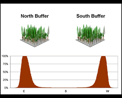
750 feet of stream reach. Note that 90 percent of all recruitment is achieved within the first 100 feet of the stream; while no recruitments are expected beyond 140 feet.

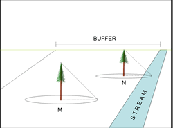
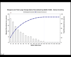
Figure 5: Visualization and recruitment
potential: unmanaged scenario.


These models provide an objective method to analyze a proposed alternate plan to the Forest and Fish default scenario. They can guide the development of management prescriptions that meet economic requirements while maintaining adequate resource protection. They can illustrate where different alternatives exceed requirements, as well as where they are deficient; and therefore where strategies that mitigate a plan’s impacts are needed. For example, a plan may provide enough shade, but inadequate LWD recruitment; this could be mitigated by a supplemental plan to provide/place LWD that meets or exceeds the functional requirements of a default scenario.
 
By developing best management plans for a number of typical site conditions, it may be feasible to develop templates that make the decision process easier.

--Jason Cross has an MS in Silviculture.


Northwest Folklife Festival


The 2002 Northwest Folklife Festival, a celebration of ethnic, folk, and traditional arts and crafts, brought forestry to the Seattle Center with the “East meets West, Forests and Woodlands” theme. The success was greatly helped by the collaborative efforts of the Washington Farm Forestry Association, Washington Forest Protection Association, Washington State Society of American Foresters and UW College of Forest Resources with booths providing educational information on forests and forestry in Washington State.

Demonstrations of old-time logging skills, such as crosscut sawing, wood chopping, log rolling, tree climbing and tree topping drew some of the largest crowds of the weekend. Participants from Washington and Idaho included University of Washington Logging Sports Team coaches Gordy Mauhl, of Carnation, WA, and Ed “Mooch” Smith, of Eatonville, WA, with Diane Ellison, small forest landowner and former World Champion logroller from Grays Harbor County, emceeing the demonstrations.

Gordy Mauhl and Dave Moses, Sr. springboard chopping at the Folklife 2002 logging sports demonstration.


Do you have Something to Say?


By going to the newly added RTI response page, you can post any questions, comments and/or suggestions you may have about our website, activities, or any other aspect of the Rural Technology Initiative. Through this feedback we hope to be able to better tailor our website and activities to meet the needs of YOU, our audience.


Defining Riparian Zone Targets for Alternative Plans


By Kevin R. Gehringer

A method for defining management targets that is able to represent desired riparian forest structures is needed to support the alternate planning process. An assessment procedure is also needed to determine whether a candidate alternate plan is considered acceptable relative to a specified target. RTI has developed an approach for defining riparian forest management targets and assessing whether a forest stand produced by an alternate plan meets a target. The target definition and assessment methods are based on structural characteristics of a representative sample of old-growth riparian forest stands.

Three factors should be addressed to ensure that riparian management targets provide adequate protection when compared to the default Forests and Fish Rules. First, the target definition method should include the inherent natural variability of riparian forests. Second, the target definition method should recognize the multidimensional nature of riparian forest structure. Third, there should be an objective assessment procedure to determine whether an alternate plan would produce riparian forest structures that are statistically indistinguishable from a specified target and, hence, be acceptable.

Natural variability of forests: Forest structure is highly variable and no single statistic, such as an average, can adequately capture the variability and be considered representative. A target definition method should therefore include the inherent variability of the desired riparian forest conditions. By including this variability when defining management targets, a range of possible values may be considered as representative. This provides a more detailed description of the desired conditions than any single value would.

Multidimensional characteristics: No single forest characteristic (stand density, basal area per acre, site index, average height, etc.) can adequately describe a desired riparian forest structure. For example, two stands having identical basal area per acre might be composed of a large number of small trees or a small number of large trees. Basal area alone does not distinguish between these two conditions. Multiple forest stand characteristics, such as stand density, average diameter, and average height, should therefore be used simultaneously to represent forest structure when defining forest management targets. Including more information in the target definition by using multiple characteristics provides a more detailed description of the desired forest structure than any single characteristic.

Assessment procedure: Given a target that defines a set of desired riparian forest conditions, an assessment procedure is necessary to determine whether or not a stand managed under an alternate plan will meet that target. The assessment procedure must be compatible with the target definition by accounting for the natural


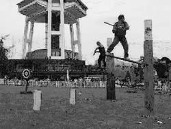
variability of the desired forest structures and allowing the use of multiple characteristics to describe these structures. An assessment procedure of this sort will better identify the desired forest structures, better discriminate between desirable and undesirable forest structures, and provide more management flexibility than an assessment procedure limited to a single characteristic described by its average value.

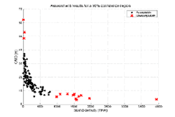
Example: An example demonstrating the target definition method is shown in Figure 1. In this example, a sample of 127 old-growth riparian stands is plotted by two structural characteristics: stand density (TPA) and quadratic mean diameter (QMD). QMD, the diameter of a tree with the average basal area, combined with TPA, reveals both density and structural characteristics. The sample includes 89 stands used to develop the basis for the desired future conditions (DFC) basal area targets in the Forests and Fish Rules. The target in this example is defined by 17 stands between the ages of 120 and 160 years, and is represented as black dots in Figure 1. The target stands overlap the central portion of the larger data set, where most of the stands are located, and they should provide for a good target definition. A target for use in the alternate planning process would use the majority of the available old-growth riparian stands, not just the 17 points used here to illustrate the ideas.

Figure 1: QMD vs. TPA for 127 old-growth riparian stands are plotted. 17 of these stands are selected as the “target,” which is representative of the bulk of the data.


Figure 2 shows results from the application of the assessment procedure using the target and observation data from Figure 1. Stands identified as acceptable by the assessment procedure are those that are statistically indistinguishable from the target. The bulk of the stands, located around the elbow of the data, are considered acceptable, as should be expected. The unacceptable stands appear in the two tails: low density stands with very large trees and high-density stands with small trees. The former stands, though biologically desirable as old-growth, fall outside the realm of possibility for managed forest stands using the 140 year time horizon defined by the Forests and Fish Rules.


Continued down to next page


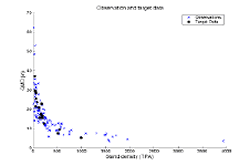
The high density stands represent a biologically undesirable stand condition that will most likely not develop the desired old-growth-like structures.
Figure 2: Acceptable and unacceptable stands based on their statistical similarity to the target.

It is important to note that for these riparian stands, the desirable condition cannot be distinguished from the undesirable condition using basal area alone. Many managed riparian stands are currently over stocked, as they were being managed with the expectation that they would be thinned. They are representative of undesirable stands with high densities and small trees. It is likely that thinning activities not contemplated under the default Forests and Fish Rules could better duplicate the desired forest structures than management under the default rules, while at the same time reducing costs. By using two stand characteristics (TPA and QMD) simultaneously to provide more information, a better representation of the forest structure is obtained, allowing stands that are desirable or undesirable to be more easily distinguished from one another.

In contrast to the DFC basal area targets in the Forests and Fish Rules, the riparian forest management targets described here define a desired target, regardless of the age at which that structure is achieved. Obtaining the desired forest structure sooner may be more beneficial both ecologically and economically than obtaining it later. By emphasizing forest structure, incorporating the inherent variability, and using multiple stand characteristics to describe the desired forest structure, we can more reliably assess management options that could obtain the desired structural conditions.

These target definition and assessment procedures may be used to provide a scientifically rigorous evaluation of potential alternate plans. The incorporation of natural variability via the distribution of riparian stand structural characteristics permits the use of well-accepted statistical techniques and concepts to produce compatible approaches for target definition and assessment. The use of multiple stand characteristics to define a target provides more information about stand structure than a single characteristic, increasing the discriminatory power, and making it easier to identify alternate plans that will obtain the desired forest conditions.


  The use of stand characteristics from actual old-growth riparian forest stands in these procedures allows us to identify desired conditions based on “real world” conditions. Finally, defining management targets based on forest structure rather than a specific stand age places a greater emphasis on forest biology, as represented by the stand characteristics used to define a target and assess potential alternate plans.

This process may be reducible to simple templates. By evaluating a number of typical stand situations under a range of alternate plans, it may be practical to develop templates for many current stand conditions. Templates will simplify predictions of acceptable and unacceptable alternate plans, making it possible to streamline the approval process, create greater management flexibility, assume achievement of desired future conditions, and reduce costs to landowners.

--Kevin Gehringer has a PhD in Forest Mensuration.


Washington State DNR Small Forest Landowner Database, 2002

Last year, RTI working as a contractor to the Small Forest Landowners Office (SFLO) of the Department of Natural Resources completed the first phase of a project to gather and analyze available tax data on lands in Washington designated as non-industrial forests. Some of the demographic insights from this land use analysis were presented in the Fall 2001 publication of the RTI Newsletter. Findings have been outlined as well in a broader report that was prepared by the Small Fores Landowner Office of the DNR and submitted to the state legislature. The second phase of the Small Forest Landowner Database project has been to develop and demonstrate a methodology for validating land use status results using remote sensing technology. Better information on land owner demographics will help the State Legislature to better understand the critical role that small forestland ownership plays in the future of Washington State.

Clark, King, and Whatcom counties were selected as three of the western Washington counties that have the most accurate data and Geographic Information Systems (GIS) capabilities. Using ArcGIS®, RTI analysts have been able to utilize the counties’ parcel data in conjunction with LANDSAT and high definition aerial photos (orthophotos). This combination of tabular and spatial data allows a visual comparison of forested and non-forested land against status as filed in tax records. Since 100’s of 1000’s of parcels must be examined during this validation process, a typing system has been designed to enable a computer program to identify and record the forested attributes from satellite images and orthophotos and to then determine accuracy in the tax records. RTI is nearing full verification of the land use parcel data from Clark, King and Whatcom counties. Further phases of this project, pending funding availability, are anticipated for the assessment of data from other counties. RTI image technology will be available for other remote sensing applications such as aerial analysis of insect infestations, forest fire risk, or land use conversion trends.


Readers may send comments to:

Bruce Lippke, Director RTI
CFR, University of Washington
Box 352100
Seattle, WA 98195-2100
Phone: 206-616-3218
email: RTIu.washington.edu

Janean Creighton, Editor RTI News
Department of Natural Resource Sciences
Washington State University
PO Box 646410
Pullman, WA 99164-6410
Phone: 509-335-2877
email: creightonwsu.edu

 
School of Environmental and Forest Sciences
USDA Forest Service State & Private Forestry
WSU Cooperative Extension
The Rural Technology Home Page is provided by the College of Forest Resources. For more information, please contact the Rural Technology Initiative, University of Washington Box 352100 Seattle, WA 98195, (206) 543-0827. © 2000-2004, University of Washington, Rural Technology Initiative, including all photographs and images unless otherwise noted. To view the www.ruraltech.org privacy policy, click here.
Last Updated 10/13/2022 12:22:34 PM