 |
 |
 |
 |


Winter 2004, Volume 4, No. 2
Click here for a PDF copy of this Newsletter!Table of Content
|
||||||||||||||||||||||||||||||||||||||

| The Human
Dimensions of Family and Farm Forestry Symposium
March 29 - April 1, 2004
The objective of this symposium is to bring together scientists and practitioners from all corners of the world to discuss research problems, results, and practical applications related to human dimensions of family, farm, small-scale, nonindustrial private, and community forestry. For more information and to register, visit the symposium website: http://www.familyforestrysymposium.wsu.edu/ or call 509-335-2963. |
March 2-3, 2004 The first greater eastern Oregon regional small diameter wood products fair will convene leading businesses, community leaders, and entrepreneurs to shape the future of the wood products industry. More than 200 people will gather for two days of workshops, panel discussions, exhibits, product design competitions, and networking events that will help eastern Oregon become a leader in ecosystem restoration, wildfire risk reduction and wood products utilization. For more information or to register, visit the conference webiste at http://www.wallowaresources.org/woodfair/index.htm or call 541-426-2311. |
|

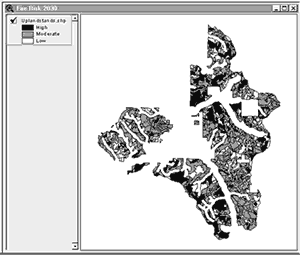
New Technology Enables Fire Risk Mapping from within LMSThe incidence and intensity of large scale forest fires throughout the west have increased dramatically in recent years. As a result, forest fire risk reduction has become an important forest management issue. In dealing with this issue, it is helpful for managers to understand the spatial distribution of stands at risk on the landscape. With this information, managers can prioritize risk-reduction efforts in areas where such efforts are likely to have the greatest benefit at the least cost.RTI has developed a new tool called the Risk Mapper that works with the Landscape Management System Fire and Fuels Extension (LMS-FFE) Add-on (see article in the Fall, 2003 RTI Newsletter for more information about this fire risk assessment program). The Risk Mapper links stand level risk assessments from LMS with spatial data, allowing managers to easily create visual maps of fire risk. These maps can be used to evaluate present risk conditions as well as to compare the effectiveness of simulated fire risk reduction treatments across real forested landscapes.
|
The Risk Mapper works as a customized ESRI ArcView project file that maps fire risk based on Forest Vegetation Simulator - Fire and Fuels Extension (FVS-FFE) outputs of crowning index. FFE is a fire effects model developed by the US Forest Service for use with the FVS growth model. Variants of FVS-FFE are available for the majority of the fire-adapted ecosystems of the Western U.S., including the Eastern Cascades, Inland Empire, Rocky Mountains, Sierras, and Siskiyous. All FVS-FFE variants are installed by the LMS-FFE Add-On, which is available for free download from http://lms.cfr.washington.edu/lmsdownload.php. The Risk Mapper is now included with the LMS-FFE Add-on for use in conjunction with ESRI’s ArcView 3.x program. Maps of fire risk are created for individual years that are selected by the user. Fire risk is classified based on crowning index, which is the potential wind speed at 20-feet above the ground needed to initialize and carry a crown fire in a forest. High risk stands have a crowning index value of 25 miles per hour (mph) or less. Moderate stands have a crowning index of 25 – 50 mph. Low risk stands have a crowning index value of 50 mph or more. Use of the Risk Mapper requires a landscape visualization-enabled
portfolio that includes a ESRI shapefile of stand boundaries.
ESRI ArcView 3.x must also be installed on the computer. For
additional information regarding the Risk Mapper, contact
Kevin Ceder at thuja
- Kevin Ceder, RTI Staff - |
RTI Receives Formal Technical ReviewIn September, 2003, RTI was visited by six professionals, chosen by the USDA’s Cooperative State Research , Education, and Extension Service, to conduct a comprehensive review of the RTI program.
|
This review was requested by RTI for the purpose of gaining external insight and input to the operation of RTI and to address the program’s sustainability. At the end of the review, a report was submitted to RTI by the review team incorporating their conclusions and recommendations, which were generally positive. The following is an excerpt from the concluding remarks of the report: “Based on the Review Team’s exposure
to RTI, the Review Team is able to affirm that RTI has made
major contributions toward providing usable technology to
rural forest managers. Numerous testimonies boasted of the
services and knowledge rendered to them by the RTI program.
Additionally, many of the stakeholders reported that the material
and knowledge provided to them was cutting edge and would
not have been available under conventional university and
other outreach structures. They also reported that the material
was applicable to a regional and possibly national constituency.” |

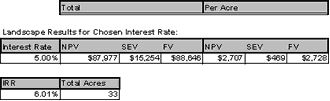
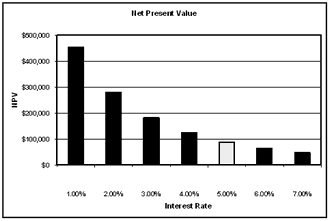
Economatic Adds Robust New Economic Analysis Features to LMSRTI has completed development of “Economatic,” a new economic analysis tool for use in the Landscape Management System (LMS). There are a number of economic and financial analysis programs that are available to forest managers and landowners. However, Economatic is unique in that it is directly integrated with the growth modeling and treatment simulation capabilities of LMS. Unlike other tools that require the user to enter estimates of future cash flows, the Economatic automatically calculates those cash flows and their timing based on volume and value outputs from LMS. This can greatly simplify economic analysis for both novice and advanced users doing applications that might range from tree farm estate planning to analysis of species planting alternatives on state forests.Economatic can automatically compute and chart a whole suite of useful values from any LMS management simulation. For basic scenarios, Economatic will chart cash flows over time and calculate the net present value (NPV) of those cash flows. For specialized scenarios, Economatic can calculate what is known as bare land value or soil
|
expectation value (SEV) as well as a total forest value. It can even compute the internal rate of return (IRR) for certain types of management scenarios.
For advanced users, all of the parameters in Economatic can be completely customized, including logging costs, operational costs, annual costs, and tax rates. By adjusting these parameters, users can quickly and easily assess the impact of a given variable on final outcomes. All outputs from Economatic can be computed at a single discount rate or across multiple discount rates as part of a built-in sensitivity analysis. Economatic is run as a table from within LMS. As with all LMS tables, Economatic is based in Microsoft Excel, which eliminates the need for specialized software. Economatic and its tutorial are included with the current version of LMS, which is available for free download from http://lms.cfr.washington.edu/lmsdownload.php or on CD-ROM upon request. - Kevin Zobrist, RTI Staff - |
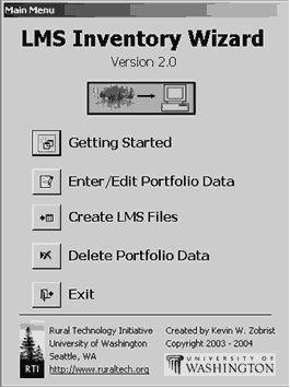
Inventory Wizard 2.0 Makes it Even Easier for Users to Get Started with LMSOur Summer, 2003 newsletter featured a new tool called the Inventory Wizard. This tool was developed in response to numerous feedback we received from people looking for a more user-friendly way to import their own forest data into the Landscape Management System (LMS). The LMS Inventory Wizard has been well-received, but thus far its use has been limited both geographically and by certain system requirements. The release of LMS Inventory Wizard version 2.0 brings significant enhancements that remove these limitations and make the tool easier to use for broader audiences.Version 2.0 of the Inventory Wizard includes species and location data for all 18 growth models included with LMS, making it applicable for almost all regions of the U.S. A new “Getting Started” section has been included that guides users through the selection of an appropriate growth model, explains what data is necessary to get good results with that growth model, and even includes data collection forms that can be printed out and used in the field. This eliminates previous ambiguities regarding field data requirements and helps landowners to know exactly what they need before going to the woods to take measurements. Another enhancement included in Inventory Wizard 2.0 is the ability to store and manage data for multiple portfolios instead of just one at a time. There is also better data validation code and “plain English” error messages that help users avoid common mistakes. In addition, a new LMS file creation process allows users to create an LMS portfolio in one step from inside the Inventory Wizard, eliminating the sometimes complicated process of importing data from the Inventory Wizard into LMS. |
Many users will be pleased to know that Microsoft Access Runtime components can now be installed along with the Inventory Wizard. Previously, Access 2000 or later was required for the Inventory Wizard to work, which was a significant system limitation for many users. While the runtime components may not work for all computer configurations, it will allow significantly more users to take advantage of this tool.
The LMS Inventory Wizard 2.0 and the Access Runtime components
are available for free download from - Kevin Zobrist, RTI Staff - |
Streaming Video Presentations Now Available Online for:Innovation for Survival of the Northwest Forest Sector: An Integrated Approach This one-day workshop was held in November at the WSU-Puyallup campus focusing on innovations in products, management, log marketing and policy. To access, visit www.ruraltech.org/video/innovation/index.asp. |
Spring Training OpportunitiesRTI offers affordable training opportunities throughout
the year to non-industrial forest landowners, tribal foresters,
consultants, rural educators, and other interested parties
in the use of geographical positioning systems (GPS), geographical
information systems (GIS), and the Landscape Management System
(LMS). All training workshops are certified for Continuing
Forestry Education credits by the Society of American Foresters. |
||
| Fundamental
Training and Applications of the LMS Workshop |
Introduction
to ArcView and the Use of GIS Workshop |
|
 |
March 14 - 17, 2004
Pack Forest Eatonville, WA |
 |
April 11 - 13, 2004
Pack Forest Eatonville, WA |
| Participants will receive
20 Category 1 Society of American Foresters CFE credits. |
Upon completion of the
course, students are eligible to receive 15.5 Category 1 Society
of American Foresters CFE credits and the ESRI “Introduction
to ArcView GIS” certificate of course completion. |
Readers may send comments to:Bruce Lippke, Director RTI
|

