The Colville
Example portfolio, created with data from the South Deep
watershed on the Colville National Forest, will be used to
demonstrate the LMS Fire Scoping Tool (figure 1) now available
with the LMS-FFE Add-on. Simulated landscape conditions are
shown for the year 2000 (the initial inventory year) and
for 2020 following management to reduce ACTIVE and PASSIVE
Fire Type, or fire behavior, under wildfire conditions. Determination
of which stands to treat was based on the Fire Type in 2000
and 2020. Stands with a Fire Type of ACTIVE in 2000 are treated
in 2010 and any stands that would move into an ACTIVE Fire
Type by 2020 are treated in 2020. The treatment prescribed
for the stands is removal of all trees except Douglas-fir
or western larch followed by a thinning from below of the
Douglas-fir and larch to leave 45ft2 of basal area.
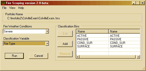 |
| Figure 1: Fire Scoping Tool used for fire analyses
in the Landscape Management System |


Enabling an LMS portfolio to run FFE-FVS
and set fire weather and fuel moisture conditions is accomplished
with the LMS-FFE Configuration Tool (part of the LMS-FFE
Add-on installation). When FFE-FVS is enabled for a portfolio,
the Potential Fire Report, which contains information about
fire behavior and effects for each stand if a fire was
to burn in the stand under severe or moderate conditions,
can be turned on to do landscape-level fire analyses with
LMS. Default measures for wind speed, fuel moisture, and
air temperature are provided for both extreme and moderate
conditions or can be adjusted within the LMS-FFE Configuration
Tool by the user to better replicate local fire conditions.
Once FFE-FVS options have been configured, the simulated
forest landscape can be “grown” and stands “treated” in
either 5- or 10-year cycles as selected by the user. FFE-FVS
fire metrics are created within LMS for the initial condition
and for each growth period simulation. Summaries of Potential
Fire Report outputs, created by the LMS Fire Scoping Tool,
are presented as acreage distribution charts in the Fire
Scoping Report, a Microsoft Excel® template, and/or
as maps in ESRI ArcView 3.x using one of five fire behavior
and effects variables, selected by the user, as the summary
variable:
- Crowning Index: 20-foot wind speed needed to initiate
and carry a crown fire (severe conditions only)
- Torching Index: 20-foot wind speed need to torch individual
trees (severs conditions only)
- Fire Type: Description of fire behavior:
- ACTIVE: Crown fire;
- PASSIVE: Surface fire with torching of individual
trees;
- COND_SUR: Conditional fire. Canopy
conditions exist for crown fire but
may lack ladder fuels
or predicted
flame length may be too short to
ignite canopy. Crown fire may
occur if flames reach canopy from
ground or neighboring stand; or
- SURFACE: Ground fire
- Flame Length
- Percent Basal Area Mortality
When weather and moisture conditions and a classification
variable have been selected, the range of the selected
variable for all years in the simulation period is sorted
automatically for classification into four equal-width
bins, with one bin for each category. Using the full range
of the data allows distributed classifications for comparability
that are the same for all years. The number of bins, range
of bins, and names of the bins, however, are also fully
configurable by the user for maximum flexibility in the
analysis capabilities. For example, high, moderate, and
low fire risk can be estimated for each stand plot in the
simulation dataset based on the Severe Crowning Index assessment
from the Potential Fire Report produced by FFE. The estimated
Crowning Index is the estimated wind speed in miles per
hour (mph) at 20 feet off the ground that is needed to
sustain a crown fire. The “High risk” bin might
be for all stands <25 mph (in other words very little
wind needed for a crown fire), the “Moderate” bin
all stands 25 – 50 mph, and “Low” all
stands with >50 mph estimated Crowning Index.
The FFE Variable Distribution Report from the LMS Fire
Scoping Tool has been designed to assist in the selection
of variables for the analysis. An examination of the
distributions of the available classification variables
can help with the determination of an appropriate number
of bins and bin limits that fit the particular analysis
need. All variables, other than Fire Type, are continuous,
numeric variables where a range is set for each bin.
Fire Type is a categorical variable and each bin represents
a unique value. For this example, below, Fire Type with
severe fire weather and fuel moisture conditions is used
as the summary variable resulting in the graphs in the
Fire Scoping Report (Figure 2) and maps in ArcView (Figure
4) of Fire Type.
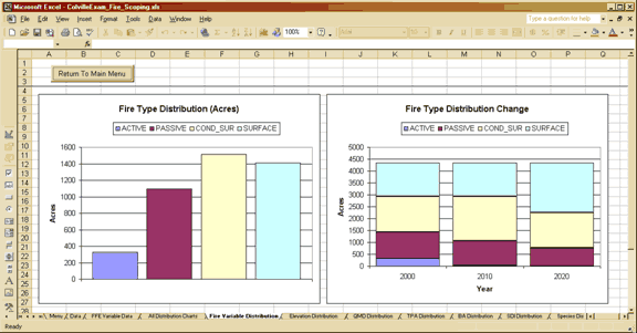 |
| Figure 2: Fire Type distributions for the year 2000
and under 20 years of mangement for ColvilleExam portfolio
in Fire Scoping Report created by the LMS Fire Scoping
Tool |
Distributions of the selected fire variable, Fire Type,
for this analysis, shown in Figure 2, in the Fire Variable
Distributions
worksheet is just one of the pages of graphs automatically
available from the Fire Scoping Report (Figure 3). In
addition to the acreage distribution of the selected fire
variable
in the initial year (left, above) and each year of the
simulation (right, above), distributions of elevation
and stand structure
variables, including quadratic mean diameter, trees per
acre, basal area, Reineke’s stand density index,
dominant species, and canopy structure are available
in other worksheet
pages with each bar of the distribution chart classified
by the fire variable. The classified charts can be used
to quickly gain better understanding of the characteristics
of stands across the landscape and the interrelation
of stand structure variables in regards the fire variable
of interest. Since stand changes are simulated in
LMS to occur because of growth and treatment, changes
in
the
 |
fire variable distributions can be related
to changes in stand structure for comparative assessment
of the
effectiveness of treatments in changing fire risk and
behavior.
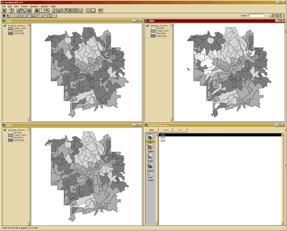
Spatial distributions of stand fire attributes across
a landscape can have important implications for management
planning and protection of homes, transportation,
or critical habitats. Maps of the selected fire variable
for each year of an LMS simulation are made quickly
by using the LMS Fire Scoping Tool to display output
attributes in ArcView. Stands automatically appear
in gray-scale but the legends for each year can be
modified, changing colors and classification limits
and/or names to fit specific analyses. Further spatial
analysis can be done by adding GIS layers to display
stand attributes for additional years in the simulation
period from the LMS Fire Scoping Tool (Figure 4). |
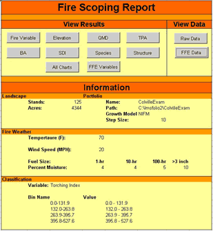
| Figure 3: Fire Scoping
Report User Interface |
|
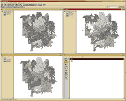 |
| Figure 4: Maps of Fire Type in ESRI
ArcView 3.3 created by the LMS Fire Scoping Tool |
The addition
of the Fire Scoping Tool and FFE-FVS expands the suite
of analyses capabilities within LMS to include fire behavior
and effects. Now an LMS portfolio of a landscape with actual
forest inventory and topographic data can be used to quickly
assess and compare fire effects and behavior under various
management regimes. Designing effective stand fuel treatments
for changing fire effects and behavior is assisted as well
by other functionalities embedded within LMS such as inventory
characteristics, economics, habitat indices, structure
classes, visualizations, and more. Stand and map outputs
from the LMS Fire Scoping Tool help guide fuel treatment
planning by highlighting areas of most urgent need for
prioritized fuel treatment scheduling.
For further information about LMS see CFR Fact
Sheet #1 and the LMS
web site.
For further information about FFE-FVS see the FFE-FVS
web site.
|