|
2003
By Florentiu Damian
|
Save or Print a PDF
copy of Fact Sheet #19
Forest roads are built to provide transportation routes
for timber harvests, forest management, recreation, fire access
and other needs. A high density of forest roads in some areas,
coupled with intense traffic has caused environmental problems
related to sedimentation. Fine sediment in solution with run-off
generated by roads is sometimes transported into adjacent
streams, leading to water quality degradation and damage to
aquatic habitat. Public concerns about such potential impacts
have resulted in regulatory design restrictions to reduce
harmful impacts from forest roads. Various road construction
techniques like road abandonment, gating, road resurfacing,
cut slope re-vegetation and sediment trapping, intended to
counteract sedimentation, have been applied with mixed results.
When a systems approach is employed for road design, cross
drains can be customized as a technique to reduce sedimentation
at less cost than default regulations that are based upon
prescriptive spacing.
|
|
Why cross drain systems?
Cross drain systems are necessary for maintaining natural water flows,
preventing drainage ditch overflow and road surface saturation. When
cross drains are constructed, sediment reduction can be achieved by
dispersing sediment-laden water onto vegetated slopes that filter
ditchwater before it reaches neighboring streams. Current forest practice
rules impose a particular set of restrictions on forest road construction
and cross drain system design. In most cases, cross drains are to
be spaced at regular prescribed intervals along a forest road to disperse
ditchwater runoff onto the forest floor. The distance between culverts
is determined as a function of road grade, side slope, average distance
above streams, road surface condition and use, precipitation, and
soil erosion potential. However, the prescriptive approach to cross
drain placement when compared with customized cross drain placement
based upon sediment flow analysis can produce more sediment and increase
road construction cost (Figures 1 and 2).
|
|
|
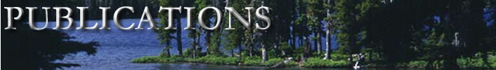
Figure 1 - Sediment delivery from road
network with 16 culverts in place.
|


Strategic location of the culverts in a cross drain system can
have a significant impact on reducing sedimentation without interfering
with road drainage functions. Location of cross drain culverts
customized to local ditchwater and sediment flow conditions may
result in maximum
efficiencies and reduced cost if road designers have access to
sediment calculators. A handful of computerized tools have been
designed
for analyzing sedimentation from forest roads. Unfortunately, currently
available road design tools are difficult to use for cross drain
spacing analysis. A specific cross drain analysis tool that is
easy to use could help road designers minimize road construction
costs
while protecting water quality in forested streams.
|
|
|
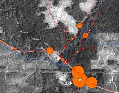
Figure 2 - Sediment delivery from road
network with 13 culverts in place.
|
What is CulSed?
CulSed is a new decision support tool for cross drain culvert design
developed by research assistants and staff at the Rural Technology
Initiative (RTI). This software can be used to evaluate the sediment
delivered to the stream at each cross drain location based on road
and stream geometry, terrain morphology and user input sediment-producing
road characteristics. CulSed is a specialized graphical user interface
(GUI) for a sediment model that is used in a geographic information
system (GIS) with topographical, hydro, and road layers. The probable
sedimentation at each cross drain location is automatically calculated
and drawn on screen with proportional symbols (Fig. 1). Evaluating
relative sediment impacts from a road network becomes a user-friendly
exercise. The click and drag function is used to simulate moving
a culvert on screen to a different location along the road. Instant
recalculation of the sediment load results in a resizing of proportional
flow symbols. CulSed enables users with little technical training
to find near optimal cross drain locations. Fig. 2 displays a reduction
in sedimentation for this sample road system of approximately 57%
from the default WA Forest Practice rules approach presented in
Fig 1. Using CulSed to assist design, a reduction in sedimentation
was achieved while the number of culverts needed was reduced as
well. If this design had been available at time of construction,
road-building costs could have been reduced.
CulSed is simple to use but requires accurate road geometry, stream
and digital terrain data for a successful analysis. Sediment values
associated with each cross drain are modeled estimates for relative
comparison of cross drain location alternatives. RTI researchers
are using CulSed to evaluate cross-drain placement strategies in
support of non-industrial forestland alternative plans.
|