 |
 |
 |
 |


Project Brief:
Small Forest Land Owner Parcel Identification and County GIS Data Compilation for Washington State
Grays
|
| Figure 1 | - Study area |
| Figure 2 | - NOAA Coastal Change Analysis Program land cover classification |
| Figure 3 | - Forest land cover in Grays Harbor and Pacific Counties |
List of Tables
| Table 1 | - Landsat satellite image acquisition dates for the NOAA C-CAP land cover data |
| Table 2 | - NOAA C-CAP reclassification mapping into forest/non-forest land cover |
| Table 3 | - Owner types identified in the analysis and the associated codes used in the datasets |
| Table 4 | - Number of parcels and acres by owner type for all parcel sizes in Grays Harbor County |
| Table 5 | - Number of parcels and acres by owner type for all parcel sizes in Pacific County |
| Table 6 | - Grays Harbor County parcels that are taxed as forestland, or have land use codes 89, 91, or 99 |
| Table 7 | - Pacific County parcels that are taxed as forestland, or have land use codes 89, 91, or 99 |
| Table 8 | - Grays Harbor County parcels 5-acres and larger by owner type |
| Table 9 | - Pacific County parcels 5-acres and larger by owner type |
| Table 10 | - Grays Harbor County Owner Types and Acres by Parcel Sizes |
| Table 11 | - Pacific County Owner Types and Acres by Parcel Sizes |
| Table 12 | - Grays Harbor County Owner Types and Number of Parcels by Parcel Size Class |
| Table 13 | - Pacific County Owner Types and Number of Parcels by Parcel Size Class |
| Table 14 | - Grays Harbor County road crossing barrier status by owner type |
| Table 15 | - Grays Harbor County road crossing barrier status by WDFW owner type |
| Table 16 | - Grays Harbor County dam barrier status by owner type |
| Table 17 | - Grays Harbor County dam barrier status by WDFW owner type |
| Table 18 | - Pacific County road crossing barrier status by owner type |
| Table 19 | - Pacific County road crossing barrier status by WDFW owner type |
| Table 20 | - Pacific County dam barrier status by owner type |
| Table 21 | - Pacific County dam barrier status by WDFW owner type |
| Table 22 | - Grays Harbor County percent of forestland in NIPF ownership |
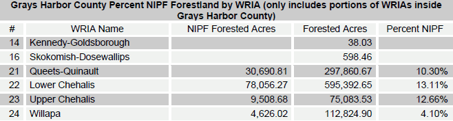
| Table 23 | - Grays Harbor County percent of forestland in NIPF ownership by WRIA |
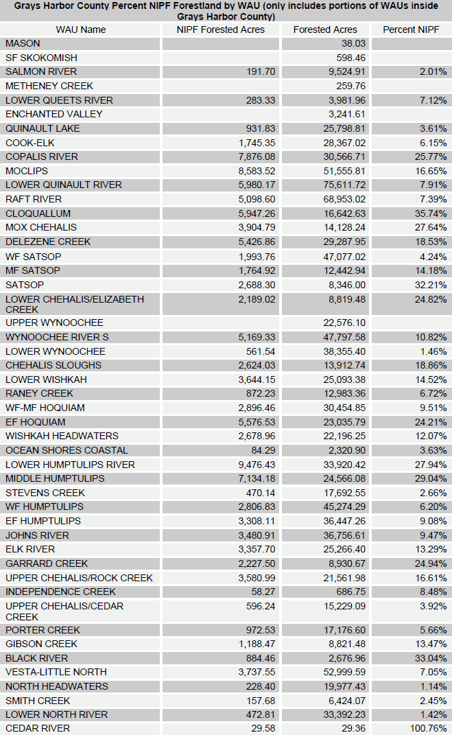
| Table 24 | - Grays Harbor County percent of forestland in NIPF ownership by WAU |
| Table 25 | - Pacific County percent of forestland in NIPF ownership |
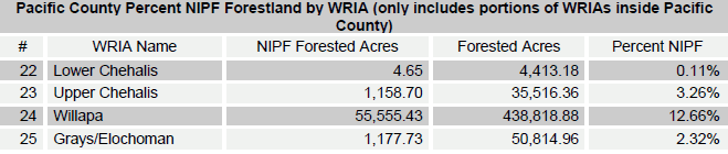
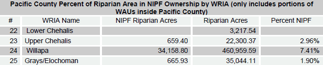
| Table 26 | - Pacific County percent of forestland in NIPF ownership by WRIA |
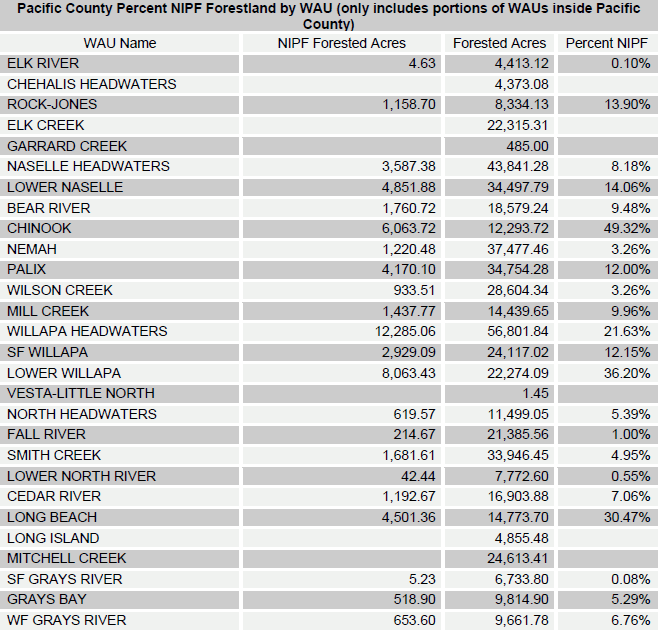
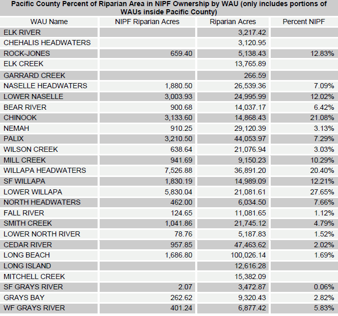
| Table 27 | - Pacific County percent of forestland in NIPF ownership by WAU |
| Table 28 | - Grays Harbor County stream miles by DNR water type code |
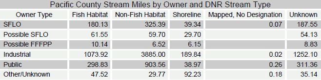
| Table 29 | - Pacific County stream miles by DNR water type code |
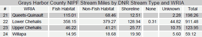
| Table 30 | - Grays Harbor County NIPF stream miles by DNR Forest Practices water type and WRIA |
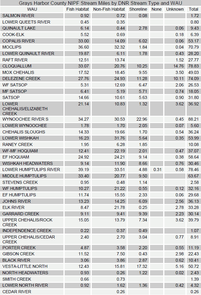
| Table 31 | - Grays Harbor County NIPF stream miles by DNR Forest Practices water type and WAU |
| Table 32 | - Pacific County NIPF stream miles by DNR Forest Practices water type and WRIA |
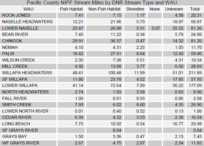
| Table 33 | - Pacific County NIPF stream miles by DNR Forest Practices water type and WAU |
| Table 34 | - Grays Harbor County percent of riparian area in NIPF ownership |
| Table 35 | - Grays Harbor County percent of riparian area in NIPF ownership by WRIA |
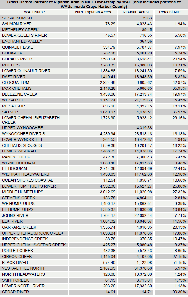
| Table 36 | - Grays Harbor County percent of riparian area in NIPF ownership by WAU |
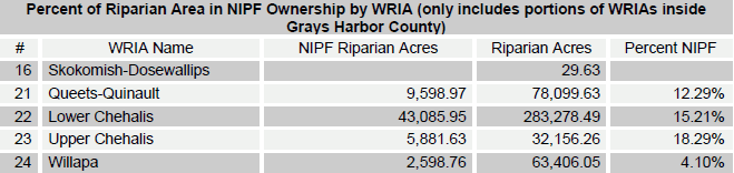
| Table 37 | - Pacific County percent of riparian area in NIPF ownership |
| Table 38 | - Pacific County percent of riparian area in NIPF ownership by WRIA |
| Table 39 | - Pacific County percent of riparian area in NIPF ownership by WAU |
Introduction
Restoration of Washington’s threatened and endangered salmon runs can be assisted by focusing restoration efforts in areas where the most habitats can be created for the least cost. The Washington State Department of Fish & Wildlife and the Department of Natural Resources, along with many local fish enhancement groups, have come together to locate and survey many of Washington’s salmon streams. These surveys produced Geographic Information System (GIS) layers which show the location, condition, and fish passage status of dams, culverts, and fishways throughout the state. This information, combined with knowledge of who owns the land, can help local groups and funding agencies identify target restoration areas.
Currently, there are a variety of stream restoration assistance programs targeted specifically at non-industrial private forestlands (NIPFs) and small forest land owners (SFLOs); however, it is difficult to identify land owners in this group without door-to-door surveys. This project provides the funding groups with targeted information and mailing lists for land owners eligible for these funding programs using a combination of GIS and tabular data analysis.
The State of Washington’s harvest-based definition of a small forest landowner created in the Salmon Recovery Act, defines SFLOs as those who harvest less than two million board feet on an annual basis [RCW 76.13.120(2)(c)]. Unfortunately, the currently available information on harvest levels is not detailed enough to locate or identify small forest land owners. Alternatively, a previous acreage-based definition considered non-industrial forests and woodlands [also known as NIPFs] as “those suburban acreages and rural lands supporting or capable of supporting trees and other flora and fauna associated with a forest ecosystem, comprised of total individual land ownerships of less than five thousand acres and not directly associated with a wood processing or handling facilities” [RCW 76.13.010(4)]. Therefore, this acreage-based definition was used in the identification of possible small forest land owners eligible for stream restoration financial assistance programs.
For the purposes of this project, identification of these small forest land owners was based on two assumptions: 1) land ownerships less than 5,000 acres and taxed as forest or timberland have a high likelihood of meeting the acreage-based definition, and 2) forested lands of certain sizes have the potential of meeting the same definition. County assessor tax roles and GIS parcels, collected from Grays Harbor and Pacific counties, were used to identify those parcels which have land use codes taxed as forestland, timberland, or open space to identify SFLOs. Additionally, classified Landsat satellite imagery of forest and non-forest cover was intersected with all parcels, regardless of land use, to identify acres of forest land on each parcel; this resulted in the identification of Possible SFLOs. With the data produced during this project, it is possible to further identify Possible SFLOs by selecting parcels with non-conflicting land use codes, such as open space or other non-residential or commercial uses, if desired.
This project summary describes the data used in the analysis, the methods used to determine SFLOs, and some general statistics about these lands.
Data
County Data
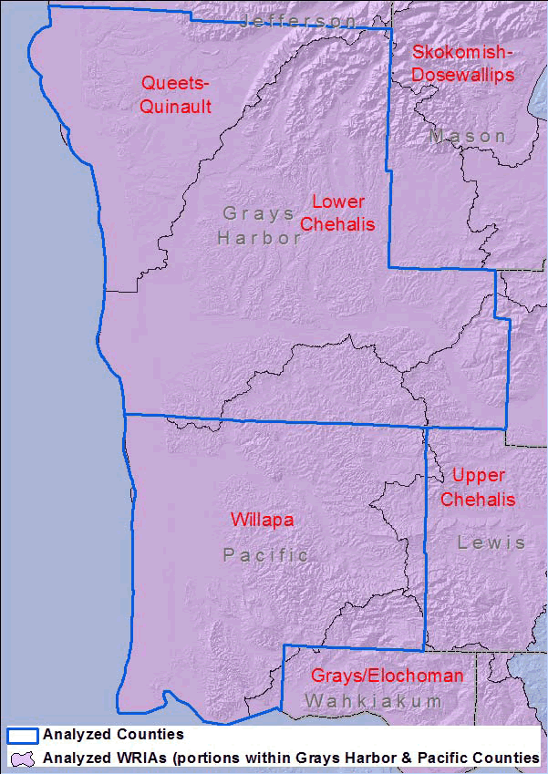
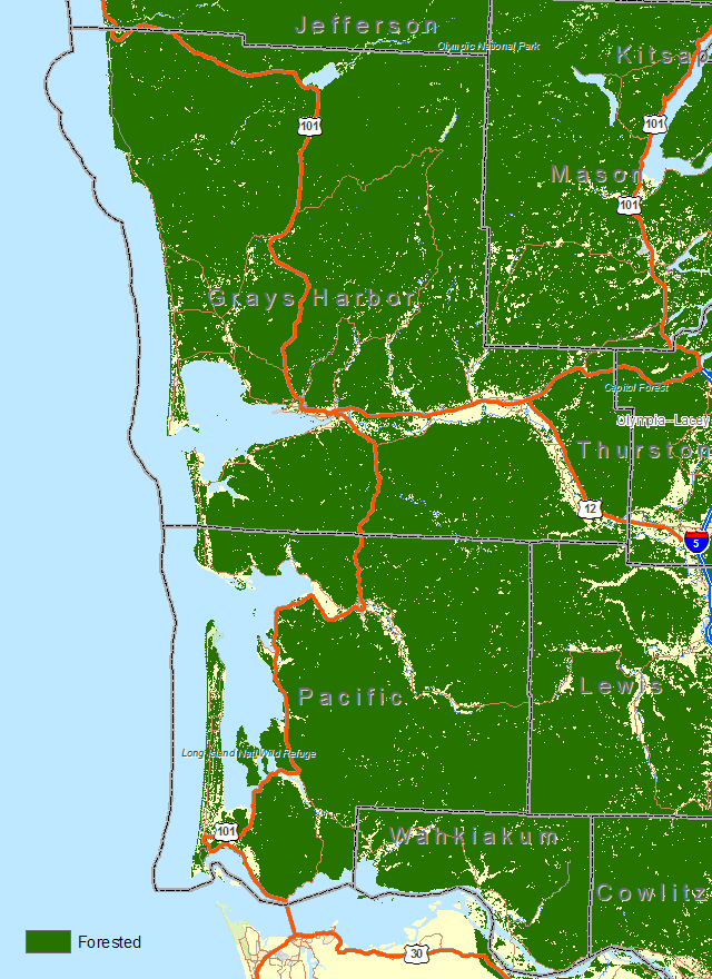
This project collected and analyzed parcel and in-stream barrier data for Washington’s southwest coastal area, limiting the study area to Grays Harbor and Pacific counties. Grays Harbor County includes major portions of the Queets-Quinault, Lower Chehalis, Upper Chehalis and Willapa Water Resource Inventory Areas (WRIA) and minor portions of the Skokomish-Dosewallips and Kennedy-Goldsborough. Pacific County includes most of the remaining portion of the Willapa and portions of the Upper Chehalis and Grays/Elochoman. Figure 1 shows the study area for this project, outlined in blue.
Previous projects covered WRIAs in Clallam, Clark, Cowlitz, Jefferson, Lewis, Thurston, and Okanogan counties. The data and results from these projects can be acquired from the Lower Columbia Fish Recovery Board and the Washington Department of Natural Resources, Small Forest Landowner Office.
|
| Figure 1 - Study Area |
Forestland Identification
Previous projects done by the Rural Technology Initiative to identify Non-Industrial Private Forestlands (NIPF) were assisted by classifying and analyzing Landsat satellite imagery. The most recent and readily available Landsat imagery for the southwestern coastal area of Washington is from the summer of 2004. Unfortunately a large portion of the study area is covered by clouds in the 2004 imagery making the analysis of forestland cover in the counties difficult and inconsistent.
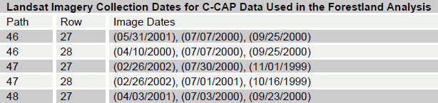
To consistently analyze forestland cover across the study area an existing data product produced by Space Imaging for the NOAA Coastal Change Analysis Program (C-CAP) was utilized, Figure 2. According to the C-CAP metadata: “This data set is the 2000 era or late-date classification of Coastal Washington. This data set consists of about 33 full or partial Landsat 7 Thematic Mapper (TM) scenes which were analyzed according to the Coastal Change Analysis Program (C-CAP) protocol to determine land cover.” The imagery acquisition dates for the Landsat scenes that were used to create the Grays Harbor and Pacific County C-CAP data are shown in Table 1.
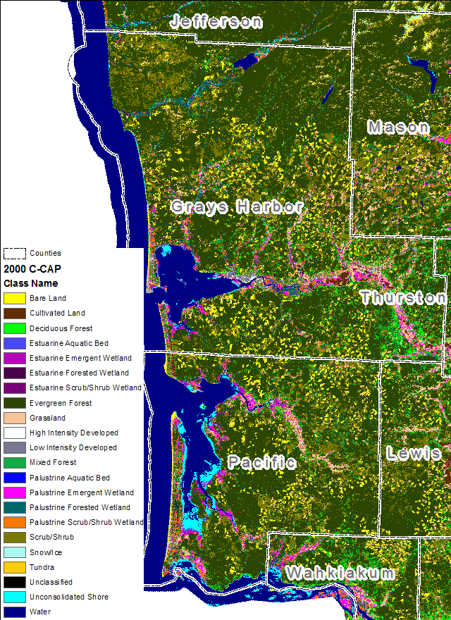 |
| Figure 2 - NOAA Coastal Change Analysis Program land cover classification. |
| Table 1. Landsat satellite image acquisition dates for the NOAA C-CAP land cover data. |
|
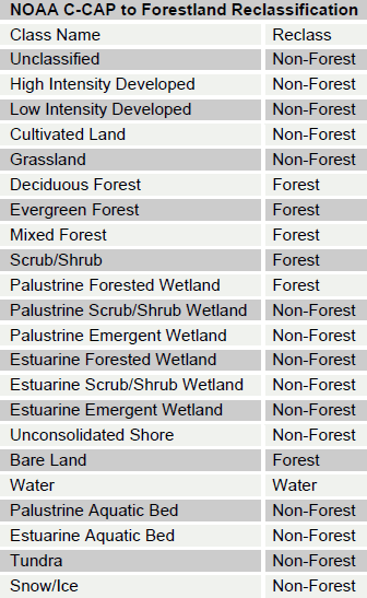
The C-CAP dataset classifies Landsat satellite imagery into 22 land cover classes. These land
cover designations were reclassified into forest and non-forest groups using the mapping in
Table 2. Reclassification from the base classes into forest/non-forest follows intuitive land cover
groupings except for the “Bare Land” classification. In Grays Harbor and Pacific county the bare
land classification is most often cleared forestland far from development and therefore likely to
be reforested. While this land is not forested in the imagery it is used as forestland and therefore
classified as forest. The reclassified C-CAP forestland is shown in Figure 3.
| Table 2. NOAA C-CAP reclassification mapping into forest/non-forest land cover. |
 |
An accuracy assessment performed by Space Imaging found the overall accuracy of the C-CAP land cover classification to be 86.1%. Grouping the original 22 land cover classes into forest/non-forest likely increased the overall accuracy of the assessment to over 90% although the exact amount is uncertain.
Using satellite images for land cover classification is limited by the pixel size and classification accuracy. Landsat images store 30 meter by 30 meter pixels, meaning that any land cover less than 900 square meters is not discernable. Furthermore, applying land cover classification to individual parcels is not entirely accurate. Nevertheless, for the purposes of this project, to identify land owners potentially eligible for financial assistance in restoring stream habitat and removing fish barriers, this level of land cover accuracy is appropriate. The users of this data, however, must use this data with caution when applying it to other projects and analysis.
 |
| Figure 3. Forest land cover in Grays Harbor and Pacific Counties |
Analysis
Standardizing Parcel Data
Counties store assessor parcel data in many different formats including ArcSDE, Geodatabases, Coverages and Shapefiles. In addition to storing the data in different formats, every county uses different attributes with diverse values. These differences make inter-county analyses difficult and inconsistent. To assist end uses of the data with their analyses, a single cross-county format was created. This cross-county format includes information like the owner name and address, the parcel size, land use, location, ownertype, timber acres, percent forest, and more. Before any analysis was done, a series of standard empty fields were added to the original parcel data from each county to allow for a final standard table.
All analysis was done using a combination of ArcGIS geoprocessing tools and Microsoft Access update and select queries. The process for each county differs, since each county stores data in different formats. A process table was built for each county, documenting the analysis steps; these process tables are shown in the Appendix, as well as saved with each county’s analysis workspace.
The data is stored in a variety of forms, all easily accessible using either ArcCatalog, ArcMap, Access, and Windows Explorer. A relatively skilled GIS and Access user could update all of the data, as well as see the process used for all parts of the analysis.
Identifying Small Forest Land Owners
Small Forest Land Owners were identified using two methods. The first method used only the county assessor’s tax roles to identify parcels that have land uses taxed as forestland, timberland, or open space. The second method used Landsat imagery to construct a forestland layer, which was intersected with the parcel data to determine percentage and amount of forestland per parcel.
Industrial and Public Owner Types
Industrial forestlands were distinguished using local knowledge of the forestry industry and unique land owners with more than 5,000 acres of land in each county. Industrial owners, such as Weyerhaeuser, Boise Cascade, Longview Fibre and other entities owning more than 5,000 acres, were not considered SFLOs and were categorized as “industrial” owners. Additionally, public lands were distinguished by a series of queries to identify land owned and administered by federal, state, and local governments. The queries used for this selection are listed in the Appendix. The remaining parcels were sorted into four categories: SFLO, Possible SFLO, and Possible FFFPP (eligible for Fish Passage Program funding opportunities), and Other/Unknown.
Land Use Codes: Identifying SFLO
County assessors typically follow a land use tax scheme that is closely related to Washington’s
state land use coding scheme. Although there are some variations, the land uses that are typically
found relating to forestland are as follows: 87 - Classified forest land, 88 - Designated forest
land, 92 - Noncommercial forest, 94 - Open space land, and 95 - Timberland. According to
county assessors, these tax designations indicate that a parcel is being managed as forestland or
is protected under a conservation agreement. Grays Harbor County followed the same land use tax scheme as the statecodes, while a parsing scheme had to be developed to extract Pacific
County’s primary land use code from their three code tax data.
Forested Acres: Identifying Possible SFLO and Possible FFFPP
The identification of Possible SFLO and FFFPP parcels required additional analysis, and was based on forest land cover analysis using Landsat satellite images. It is estimated that somewhere around half of Washington’s non-industrial private forests are not in forest tax classifications. These parcels typically have land uses that do not conflict with forestry, but little data exists on what land uses are likely. Previous analyses have focused on assessor land use codes of: 89 – Other resource protection, 91 – Undeveloped land, and 99 – Other undeveloped land. This method resulted in a significantly larger number of parcels being identified as SFLO in the previous studies.
For this analysis, however, all forested parcels of a certain size, regardless of land use
classification, were considered as possible small forest land owners to ensure that all potential
recipients of forest land assistance programs were identified. Overlaying the forest/non-forest
layer on the parcels enabled the calculation of forested acres and percent forest of each parcel.
For this analysis, parcels that were at least 5 acres with a minimum of 1 acre of forested land
(timberacres), and that were not already identified as SFLO by land use codes were considered
Possible SFLOs. Parcels between 2 and 5 acres with at least 1 acre of forested land were
identified as Possible FFFPP.
Remaining Parcels: Identifying Other/Unknown
All remaining parcels, not already identified as industrial, public, SFLO, Possible SFLO, or
Possible FFFPP, were classified as other/unknown. These included parcels less than 1-acre
and/or not taxed as forest land, timber land, or open space.
Table 3 lists the codes and short descriptions associated with the owner types assigned to each parcel during the analysis. It is important to remember that the codes are assigned based on both size of the individual parcel as well as the unique owner. For example, a parcel of land owned by a known industrial owner would be considered industrial, even if it is less than 5,000 acres.
| Table 3. Owner types identified in the analysis and the associated codes used in the datasets. |
|
Previous projects have focused on data continuity among county analyses so that cross-county queries and reports are consistent. However, for this project a new and slightly different definition was used for Possible SFLO and a new definition of Possible FFFPP was developed. The Possible SFLO definition was changed from a minimum of 5 forest acres to a minimum 5 acre parcel with at least 1 acre of forestland. The new FFFPP definition replaces the previous FPP definition with a minimum of 1 forest acre to a parcel that is between 2 and 5 acres and has at least 1 acre of forestland.
Identifying Potential Fish Blockages
By overlaying potential in-stream barriers, collected by the Washington Department of Fish and
Wildlife, over all parcels in each county, it is possible to determine which parcels may be eligible
for potential fish habitat restoration or barrier removal funding. A mailing list and dataset was
produced that lists the parcels and all respective attribute data. These attributes also include the
status, location, and other information of the culvert, dam, fishway or other structure on the
property.
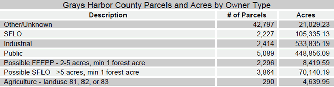
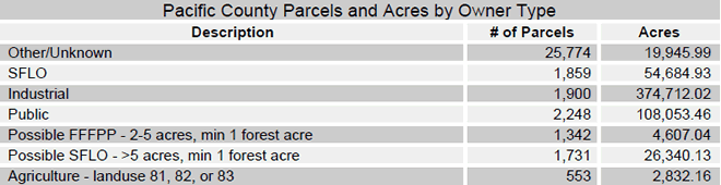
Results
Parcels
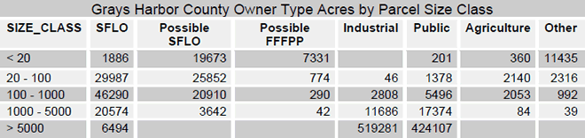
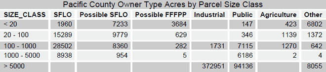
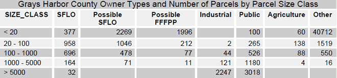
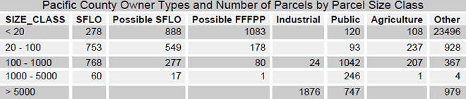
Combining assessor tax roles with remote sensing techniques yielded two to four times as many candidate 5-acre and larger SFLOs compared to using assessors tax roles alone. Table 4 and Table 5 show the number and acres of parcels by owner type for Grays Harbor and Pacific counties. The SFLO owner type parcels are the parcels that are identified by using the assessors land use tax codes. The industrial parcels are those that are owned by identified industrial corporations using the owner name in the assessors’ data. Public parcels are those identified as city, county, state, or federal lands. The Possible SFLO parcels are those that are not taxed as forestlands but have at least 1 acre of forest on a minimum 5 acre parcel. The possible FPP parcels are those that are not taxed as forestland but have at least 1 acre of forest on a 2-5 acre parcel. Additional tabular statistics can be found in the Appendix.
Since multiple WRIAs cross the county boundaries, all data is presented by county rather than
WRIA. If needed, however, the data is stored in each county’s analysis workspace by WRIA as
well as by county.
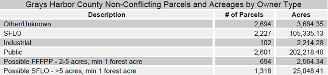
| Table 4. Number of parcels and acres by owner type for all parcel sizes in Grays Harbor County. |
|
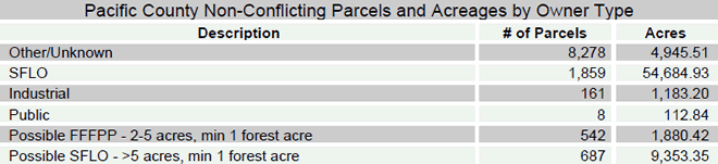
| Table 5. Number of parcels and acres by owner type for all parcel sizes in Pacific County. |
|
In addition to the identified SFLO lands that are taxed as forestland, previous analyses have identified possible SFLO lands as forested parcels that have assessor land use codes of: 89 – Other resource protection, 91 – Undeveloped land, and 99 – Other undeveloped land. The data shown in the above tables (Table 4 and Table 5) include all parcels regardless of the assessor land use code. As a comparison, Table 6 and Table 7 show the number of parcels and the corresponding acres for parcels that are either taxed as forestland by the county assessor, or have a minimum amount of forest land and a nonconflicting land use code. By limiting Possible SFLO by non-conflicting land use codes, the number of parcels was reduced to 1,316, compared to just the acreage-based definition of 3,864 parcels for Grays Harbor County. The Possible SFLOs were reduced to 687 from 1,731 for Pacific County. Depending on the objectives of the data use, one method may be more appropriate than the other.
| Table 6. Grays Harbor County parcels that are taxed as forestland, or have land use codes 89, 91, or 99. |
|
| Table 7. Pacific County parcels that are taxed as forestland, or have land use codes 89, 91, or 99. |
|
Some financial assistance programs are only directed at parcels larger than 5-acres. The data produced in this project is able to be queried for a variety of objectives and requirements. Table 8 and Table 9 show one example of a query built to pull out only parcels larger than 5-acres.
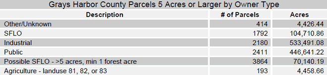
| Table 8. Grays Harbor County parcels 5-acres and larger by owner type |
 |
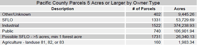
| Table 9. Pacific County parcels 5-acres and larger by owner type |
|
As shown above, a wide variety of data is stored in each county’s analysis workspace, and can be queried and summarized with ease. The following tables show the number of parcels and associated acres for identified owner types in each county, by a variety of different parcel sizes.
| Table 10. Grays Harbor County Owner Types and Acres by Parcel Sizes |
|
| Table 11. Pacific County Owner Types and Acres by Parcel Sizes |
|
| Table 12. Grays Harbor County Owner Types and Number of Parcels by Parcel Size Class |
|
| Table 13. Pacific County Owner Types and Number of Parcels by Parcel Size Class |
|
Barriers
Statistics for the inventoried in-stream features, culverts, dams and fishways, and fish passage
barrier status are shown in the following tables. The way blockage data is stored changed in 2006
and culverts, dams, and fishways are now stored in feature classes of road crossings, dams and
miscellaneous. A status of “yes” means that the barrier is a potential fish blockage, while “no” is
not a fish blockage. More information about the Washington State Department of Wildlife Fish
Passage Barrier Inventory (FPBI) database can be found in the FPBI metadata.
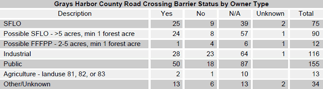
| Table 14. Grays Harbor County road crossing barrier status by owner type |
|
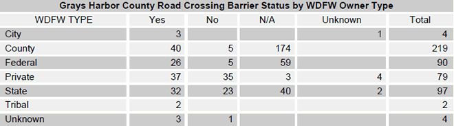
| Table 15. Grays Harbor County road crossing barrier status by WDFW owner type |
|
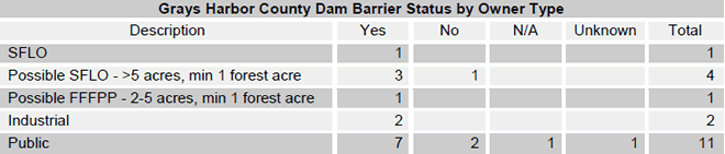
| Table 16. Grays Harbor County dam barrier status by owner type |
|
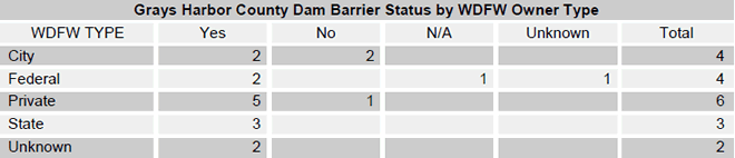
| Table 17. Grays Harbor County dam barrier status by WDFW owner type |
|
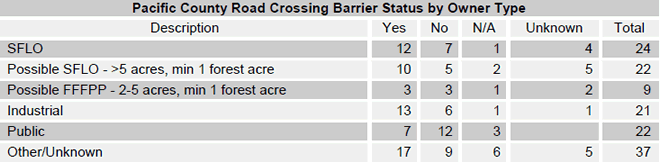
| Table 18. Pacific County road crossing barrier status by owner type |
|
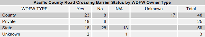
| Table 19. Pacific County road crossing barrier status by WDFW owner type |
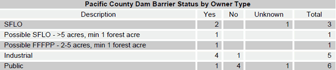
| Table 20. Pacific County dam barrier status by owner type |
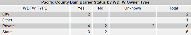
| Table 21. Pacific County dam barrier status by WDFW owner type |
Forestland Ownership
Forestland data from the NOAA Coastal Change Analysis Program was overlaid on the parcels to determine the forestland ownership patterns in each county, WRIA and WAU. All WRIA and WAU metrics are reported as a percentage of the WRIA or WAU that falls within the county boundary only. To provide statistics of forestland ownership on non-industrial private forestland by county, WRIA and WAU two owner type designations were used; SFLO (taxed as forestland) and Possible SFLO (greater than 5 acres with at least 1 forested acre). The tables below identify SFLO and Possible SFLO forestland acres by county, WRIA and WAU.
| Table 22. Grays Harbor County percent of forestland in NIPF ownership |

| Table 23. Grays Harbor County percent of forestland in NIPF ownership by WRIA |
| Table 24. Grays Harbor County percent of forestland in NIPF ownership by WAU |
| Table 25. Pacific County percent of forestland in NIPF ownership |

| Table 26. Pacific County percent of forestland in NIPF ownership by WRIA |
| Table 27. Pacific County percent of forestland in NIPF ownership by WAU |
Streams
Stream data from the Washington State Department of Natural Resources was overlaid on the parcels to determine the stream and shoreline lengths associated with the different owner types. Washington Department of Natural Resources recently reclassified all streams into new water types (previously Types 1-9): shoreline (s), fish habitat (f), non-fish habitat (n), unknown (u), and mapped with no water type (x). The DNR hydro data steward will be able to provide insights into the sefulness of the data on different types of streams, as well as comment on the accuracy of the hydro data at the parcel level. The following tables show stream statistics for hydrological water types by owner type.
| Table 28. Grays Harbor County stream miles by DNR water type code. |
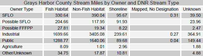
| Table 29. Pacific County stream miles by DNR water type code. |
To provide statistics of stream miles on non-industrial private forestland by water types two owner type designations were used; SFLO (taxed as forestland) and Possible SFLO (greater than 5 acres with at least 1 forested acre). The tables below identify SFLO and Possible SFLO stream miles by DNR Stream Type.
| Table 30. Grays Harbor County NIPF stream miles by DNR Forest Practices water type and WRIA |
| Table 31. Grays Harbor County NIPF stream miles by DNR Forest Practices water type and WAU |
| Table 32. Pacific County NIPF stream miles by DNR Forest Practices water type and WRIA |
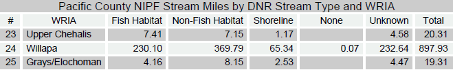
| Table 33. Pacific County NIPF stream miles by DNR Forest Practices water type and WAU |
Riparian Areas
Streams and water bodies from the Washington State Department of Natural Resources were buffered by 200 feet to create a riparian area dataset. Riparian areas were overlaid on the parcels to determine the riparian area ownership patterns of non-industrial private forestlands in each county, WRIA and WAU. All WRIA and WAU metrics are reported as a percentage of the WRIA or WAU that falls within the county boundary only. To provide statistics of riparian ownership on non-industrial private forestland by county, WRIA and WAU two owner type designations were used; SFLO (taxed as forestland) and Possible SFLO (greater than 5 acres with at least 1 forested acre). The tables below identify SFLO and Possible SFLO riparian acres by county, WRIA and WAU.
| Table 34. Grays Harbor County percent of riparian area in NIPF ownership |

| Table 35. Grays Harbor County percent of riparian area in NIPF ownership by WRIA |
| Table 36. Grays Harbor County percent of riparian area in NIPF ownership by WAU |
| Table 37. Pacific County percent of riparian area in NIPF ownership |

| Table 38. Pacific County percent of riparian area in NIPF ownership by WRIA |
| Table 39. Pacific County percent of riparian area in NIPF ownership by WAU |
Maps & Datasets
Map sets produced for the project show the location and identification information for all of the in-stream structures in the WDFW database overlaid on the known and possible SFLO and FFFPPP parcels. These map sets, see Figure 4, and the associated reports and spreadsheets can be used to locate individual blockages and the parcels that they are on. With this information, interested groups can contact individual landowners about the fish passage barrier on their property. All of the reports and maps produced for this project were products of either Access or ArcMap. The Map Series extension was used to produce the tiled maps, and the Report function in Access was used to produce the mailing lists. More information about the maps and associated reports can be found in the Appendix.
 |
| Figure 3. Example map sheet. |
Conclusion & Recommendations
Utilizing county assessor tax roles is an effective way to identify Small Forest Land Owners in Washington State. However, many of Washington’s NIPF are not taxed as forestland. Often, owners are not aware of the tax benefits associated with a forest tax classification or their parcel is too small to realize the benefit. It is estimated from previous studies conducted surrounding the 2001 Small Forest Land Owner Database that there are likely twice as many non-industrial forests in Washington State as can be identified solely from county assessor tax information. Identification of these parcels and their owners can be assisted by using remote sensing techniques (to identify forest land) in combination with county assessor tax information.
Validation of this method of identifying small forest land owners requires on-the-ground surveys of land owners. The outreach efforts of local fisheries enhancement groups can help to verify the validity of this approach. Future efforts to identify NIPF using remote sensing and assessor tax roles could benefit from information gained from these local groups.

