|
Overview | Tutorial | Notes | Data Downloads | Cooperators | Contact Info
Overview
The Fire Management Database is a tool developed to help Fire Incident Commanders identify land ownership patterns and prioritize crew response. It provides land use information and assessed property values derived from county assessor data along with property boundaries in an easy to use GIS format. Data is consistent across county boundaries allowing for comprehensive analysis and decision making. County data is primarily maintained for non-public land, allowing for analysis of risk on private properties. Some counties also maintain public property parcel data. When used in combination with available public ownership datasets, analysis and decision making across an entire landscape is possible.
The current version of the Fire Management Database is based on the 2009 Washington State Parcel Database. For more information about the development of the Washington State Parcel database, including details about source data and how it was transformed into the normalized, statewide format, please visit the project website.
The development of the Fire Management Database was made possible through the generous support of the Federal Geographic Data Committee (FGDC).
It is a goal of both the Washington State Parcel Database and the Fire Management Database to include structure information for parcels. If you are interested in partnering with us to develop this information, please contact us.
|
Tutorial
The following section will describe briefly, the various ways this database can be used to identify at risk properties quickly.
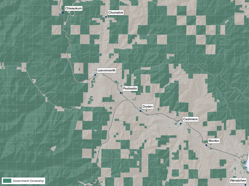
Public vs. Private Ownership
 | The quickest and most broad analysis, allows parcels to be divided into public and private ownership classes. This is done using the IsGovt field. There may be reasons to prioritize one type of ownership over another. |
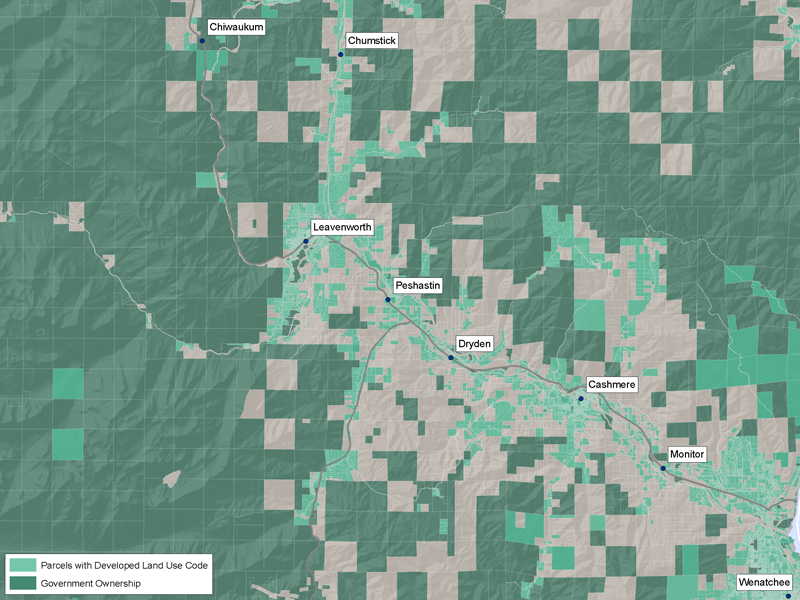
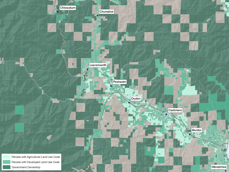
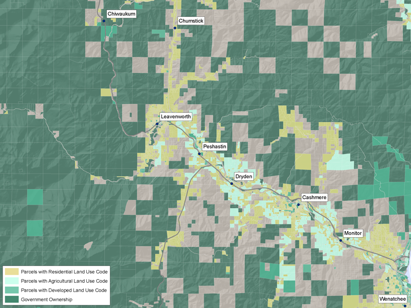
Identifying Developed Parcels
The land use code indicates whether or not parcels are developed, and what kind of development occurs on each parcel. Each Assessor is responsible for determining the land use on parcels in their county, and reporting this information to the state using the Standard two-digit land use code values as defined in WAC 458-53-30. It is possible for each parcel to have more than one land use. When a parcel had multiple land uses, the lowest value (most developed) was used.
| Land Use Code Range | Land Use Category |
| 11 to 19 | Residential |
| 21 to 39 | Manufacturing |
| 41 to 49 | Transportation, Communication, and Utilities |
| 50 to 59 | Trade |
| 61 to 69 | Services |
| 71 to 79 | Cultural, Entertainment, and Recreational |
| 81 to 89 | Resource Production and Extraction |
| 91 to 99 | Undeveloped Land and Water Areas |
The table below contains examples for how to focus in on high priority parcels using land use codes.
 | Any land use code of 89 or less indicates that the parcel has some form of development, but this does not necessarily indicate that structures are present.
Some counties report federal lands as 'government services', (LandUseCode 67) a developed land use code, although they may be more accurately described using a resource production or an undeveloped land use code. |
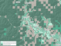 | Properties with an agricultural land use code, 81, 82, and 83, will likely have structures present.
Often, there are residential structures present. |
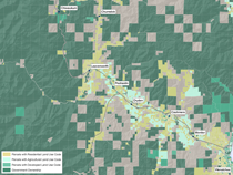 | Properties that are considered primarily residential, those with a land use code between 11 and 19, are likely to contain expensive development, and have people present. |
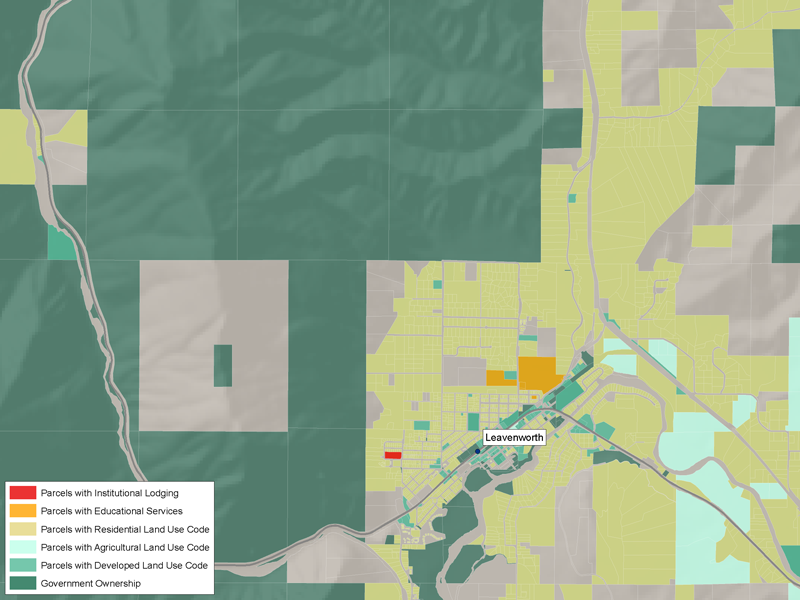
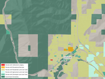 | Properties with land use codes 17 (Institutional Lodging) and 68 (Educational Services), may be considered high-priority locations. These parcels are likely to contain especially vulnerable populations. |
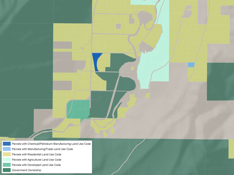
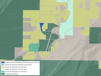 | Non-residential properties, such as those with manufacturing or trade can also be identified. In particular, chemical or petroleum manufacturing properties may present a particularly high risk. |
Using Assessed Values to Identify Structures
County Assessors visit every parcel and determine values for the land and any improvements on the property. Some Assessors determine only taxable values, some determine only market values, some determine both.
While structure information is not yet available in the Washington State Parcel Database, the existing assessed value data can be used to estimate which properties have structures. The examples below were created using assessed market values. The same methodology could be used for assessed taxable values.
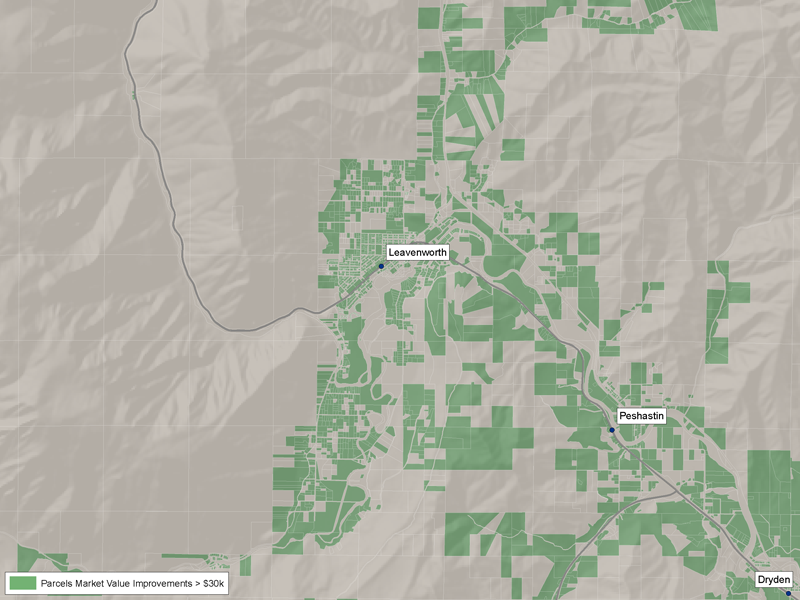
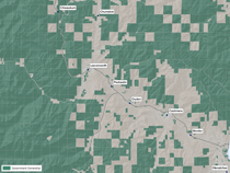
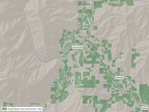 | The SumMarketValueImprovements value can be used to identify parcels with improvements, independent of land use.
The higher the improvement value, the more likely the improvements are structures. This map shows parcels with SumMarketValueImprovements values greater than $30,000. |
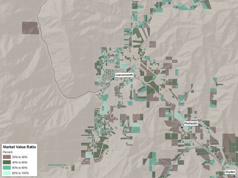
 | The MarketValueRatio demonstrates the percentage of a parcel's value that comes from improvements.
If a parcel has a high improvement value compared to its total value, this percentage will be high. If a parcel has a low improvement value and a low total value, this percentage will also be high. |
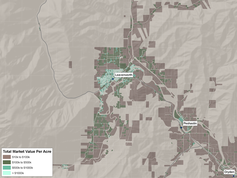
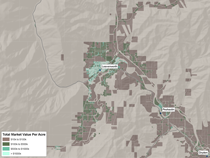 | A parcel's value is correlated with its size. Normalizing SumMarketTotalValue by each parcel's acreage, results in a value that can be compared fairly across all parcels.
High MarketValuePerAcre values indicate structures are present. |
|
Notes
Missing Data
Four of Washington's 39 counties, Asotin, Island, Pend Oreille, and Whitman, do not maintain GIS parcel data and therefore are not included in the Fire Management Database.
Two counties, Columbia and Wahkiakum, did not provide data to the Washington State Parcel Database, and therefore are not included in the Fire Management Database.
Three counties, Clallam, Lewis, and San Juan, do not permit their data to be redistributed.
Two counties, Adams and Skamania, are still developing GIS parcel boundaries. The parcel data for these counties is not complete.
Assessed Property Values
Properties enrolled in the Designated Forestlands Tax Program (RCW 84.33.140), those with State Land Use Code values of 87 or 88, do not pay property tax based on assessed value, but rather pay a tax on their timber when it is harvested. County assessors do not maintain current assessed land values for these properties, but may maintain assessed taxable values. All SumMarketValueTotal values are NULL for these parcels.
Attributes
- PolyID - A unique identifier for each parcel, created during the assembly of the Washington State Parcel Database. This can be used to connect this dataset to the full Washington State Parcel Database.
- IsGovt - A flag for whether or not each parcel is publicly or privately owned. A comprehensive list of government agency names and spellings was developed from the Washington State Parcel Database. The name of every owner of every parcel was compared to this list of government agency names to determine if it has a government or private owner.
- StateLandUseCode - The land use code of each parcel as determined by the Assessor at the data providing organization. The values provided by each organization were normalized to fit the Washington State Standard two-digit land use code values as defined in WAC 458-53-30. Values range from 1 to 99. It is possible that each parcel will have more than one land use, in which case the lowest (most developed) was selected.
- StateLandUse - The description of the Standard two-digit land use code values defined in WAC 458-53-30 for each parcel.
- GISAcres - The acreage of each parcel calculated in the GIS software.
- SumMarketValueImprovements - The sum of all of the assessed market values of the improvements on a parcel. It is possible that each parcel will have more than one tax roll and therefore more than one assessed market value for improvements.
- SumMarketValueTotal - The sum of all of the assessed market values for a parcel. This can include land (improved and unimproved) values, improvement values, and crop and timber values where they are provided by the counties. It is possible that each parcel will have more than one tax roll and therefore more than one of each of these assessed market values.
- MarketValueRatio - SumMarketValueImprovements / SumMarketValueTotal. This is the percentage of each parcels market value that is improvements.
- MarketValuePerAcre - SumMarketValueTotal / GISAcres. This is the per acre market value of each parcel. Normalizing market value by acreage provides a way to fairly compare the market values of parcels to each other.
- SumTaxableValueImprovements - The sum of all of the assessed taxable values of the improvements on a parcel. It is possible that each parcel will have more than one tax roll and therefore more than one assessed taxable value for improvements.
- SumTaxableValueTotal - The sum of all of the assessed taxable values for a parcel. This can include land (improved and unimproved) values, improvement values, and crop and timber values where they are provided by the counties. It is possible that each parcel will have more than one tax roll and therefore more than one of each of these assessed taxable values.
- TaxableValueRatio - SumTaxableValueImprovements / SumTaxableValueTotal. This is the percentage of each parcels taxable value that is improvements.
- TaxableValuePerAcre - SumTaxableValueTotal / GISAcres. This is the per acre taxable value of each parcel. Normalizing taxable value by acreage provides a way to fairly compare the taxable values of parcels to each other.
- TaxRollCount - The number of tax rolls in the Washington State Parcel Database for each parcel.
- AssessorURL - A link to online, current assessment information for each parcel, if the county assessor has a website, and if that website allows direct linking. It is possible that each parcel will have more than one tax roll and therefore more than one online record. If this is the case the record with the lowest state land use code was selected. If multiple tax rolls for a parcel have the same state land use code, the last one was selected.
|
Data Downloads
In order to download the Fire Management Database, users must register for a UW File Access account. You will be asked to provided your name, a valid email, and your Organization. You will need to confirm your email. After your email has been confirmed, administrators will approve you for access to the requested database. Register Here.
If you already have an account, you can log in and download the database directly.
Data Format Details
The Washington State Parcel Database for Fire Management contains parcel geometry and associated attributes.
| format: | ESRI ArcGIS 9.2 file geodatabase |
| projection: | NAD1983 HARN StatePlane Washington South FIPS 4602 Feet |
| size: | 513 MB zipped, 908 MB unzipped |
|
Cooperators
The Rural Technology Initiative
Our mission is to empower the existing infrastructure to use better technology in rural areas for managing forests for increased product and environmental values in support of local communities.
The Rural Technology Initiative (RTI) was established in January 2000 by a federal grant as a pilot project to accelerate the implementation of new technologies in rural forest resource-based communities. Increasing complexity from changing environmental regulations, and the recognition that new research findings are well ahead of implantation suggested the need for more rapid technology transfer. Additionally, efforts to mitigate the substantial widening gap between urban and rural incomes depend on more successful technology transfer. The UW and Washington State University Cooperative Extension developed RTI as a cooperative program with the support of a Rural Advisory Board. http://www.rurraltech.org |
The Family Forest Foundation
The Family Forest Foundation is a project organization whose mission is to promote the conservation and sustainable management of family forests. http://www.familyforestfoundation.org

The Washington Farm Forestry Association
The Washington Farm Forestry Association is a membership organization whose mission is to protect the economic viability of the small forest landowner while providing forest resource benefits such as clean water, clean air, and fish and wildlife habitat. http://www.wafarmforestry.com

Project Contact Information
Luke Rogers
206.543.7418
lwrogers u.washington.edu u.washington.edu
The Rural Technology Initiative
University of Washington
College of Forest Resources
Box 352100, Seattle, WA 98195-2100 |
|