The Rural Technology Initiative ceased operations in 2011. This site is maintained as an archive of works from RTI collaborators from 2000 to 2011 and is no longer updated. RTI's successor and remaining staff can be found at NRSIG.org


Search the RTI Website
 
Click to go to the Precision Forestry Cooperative website
Click to go to the RTI Home page
Click to go to the About RTI page
Click to go to the RTI Projects page
Click to go to the RTI Publications page
Click to go to the RTI Tools page
Click to go to the RTI Geographic Information Systems page
Click to go to the RTI Streaming Video Directory
Click to go to the RTI Training page
Click to go to the RTI Contacts page
Click to go to the RTI Image Archive
Click to go to the RTI Site Map
Click to go to the RTI Links page


Washington State Parcel Database

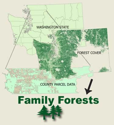
Digital parcel data stored in a geographic information system has become a critical source of information for resource land managers, community development, infrastructure maintenance, homeland security and business development. Washington State leaders, managers, researchers and business continually use GIS parcel data for decison making, science and resource management.

Redundant Efforts are Costly

It is recognized by various city, county, state and other government entities that having timely access to GIS based parcel data is critical. Currently no single source of parcel information exists in Washington State. Each public or private entity must request data directly from the counties which comes in myriad data formats and utilizes differing attribute coding schemes. Many counties have data license agreements which prohibit or severly restrict the ability of one user to share parcel data with another making cross-agency or interdisciplinary research difficult, expensive and variable since no two groups are using the same data. Redundant efforts to collect, store and manage county parcel data are occuring at all levels of government.

A Statewide Dataset is Needed

The Rural Technology Initiave, The Family Forest Foundation, The Washington Farm Forestry Association, The USDA Forest Service, Washington State Government Agencies and various other organizations are working together to create a signle source for Washington State county parcel data. The primary purpose of this effort is to develop a consolidated, consistent and documented parcel GIS dataset for use by public entities and other interested parties. Using the seamless statewide parcel database as a foundation the Rural Technology Initiative, the Family Forest Foundation and the Washington Farm Forestry Association are producing a Family Forest Database to assess, better understand and document the geography of family forests in Washington State.

Goals of the Washington State Parcel Database

  • Establish relationships with Washington's 39 counties to uderstand their parcel data needs
  • Collect parcel data from Washington's 39 counties
  • Survey current and potential parcel data users to identify what components of parcel data are important to their business needs
  • Develop a common statewide parcel data format that meets the needs of identified users
  • Work with each county to develop a protocol for transformation of individual county data into a common statewide format
  • Transform Washington State county data into common statewide format, documenting proceedures and protocols for future updates
  • Implement a collaborative parcel data distribution and update service
  • Identify long-term funding sources for support personnel, updates to the database and maintenance of hardware

Goals of the Washington State Forestland Database project

  • Leverage the Washington State Parcel Database to produce a dataset which facilitates an understanding of the geography of family forests and their ecological, economic and social contributions to the state
  • Create a historical record of the distribution of family forests around the state to better understand trends on these lands

Anticipated Benefits

  • Spatial distribution and numbers of forest lands by ownership types
  • Land use planning, zoning, and forest land relationships analysis
  • Framework for quantification of environmental services
  • Effectiveness monitoring for Endangered Species Act
  • Watershed analysis
  • Fire risk distribution

Parcel data from individual counties, combined with forest cover data, will form the base for distinguishing family forests throughout the state.

More about the Parcels Working Group and the Washington State Parcel Database can be found at the University of Washington Geographic Information Service's site.

 
School of Environmental and Forest Sciences
USDA Forest Service State & Private Forestry
WSU Cooperative Extension
The Rural Technology Home Page is provided by the College of Forest Resources. For more information, please contact the Rural Technology Initiative, University of Washington Box 352100 Seattle, WA 98195, (206) 543-0827. © 2000-2004, University of Washington, Rural Technology Initiative, including all photographs and images unless otherwise noted. To view the www.ruraltech.org privacy policy, click here.
Last Updated 10/13/2022 12:33:49 PM