|
By Santiago Mancebo and Ken Chamberlain
Introduction:
These tests were made to evaluate the accuracy of low-cost recreational
GPS receiver performance under forest canopy at the Clackamas Test
site and at the open sky control station Estacada. The following
receivers were tested:
Garmin eTrex |
Garmin GPS III Plus |
Magellan 2000XL |
Magellan Blazer 12 |
- Garmin eTrex
- Garmin GPSIII Plus
- Magellan GPS 2000XL
- Magellan Blazer
Tests were made to examine the following:
1) The accuracy of various receivers at the manufacturers defined
waypoint logging rate. All receivers logged 1 position per waypoint,
except Garmin GPS III Plus which allowed user defined waypoint logging
times. Waypoints were logged at 1 position and 60 positions for
this unit.
2) The efficiency of receiver performance. Since these receivers
do not record data to memory efficiency was observed non-quantitatively
by simply observing the receiver performance under the canopy
for number of positions determined during the work.
No attempt was made to evaluate the ease of use, menu systems,
or other user-interface features.
These tests were made between June 21 and 22, 2000.
All tests were made with Selective Availability (SA) off.
Equipment:
All the receivers tested have 12 parallel channels.
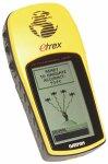
- Garmin eTrex: This is a very small, lightweight unit,
field ruggedized with some armoring, and waterproof unit that
stores 500 waypoints. Battery life is about 22 hours for 2 AA
batteries. This receiver has PC communications with an optional
data cable allowing uploading of waypoints. Weight is 6 ounces.
Display is 64 x 128 characters. The cost of this unit is approximately
$120.
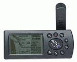
- Garmin GPS III Plus: This is a small, lightweight, and
waterproof unit that stores 500 waypoints. This is the only receiver
tested with base map capability. It has a 4 color grayscale background
map display and can store up to 1.44mg of Garmin format map data.
No map other formats are supported these maps are on an optional
CD at 100,000 scale, the cost is an additional $120. A data upload
cable is supplied for uploading maps and waypoints. Display is
100 x 160 characters. Weight is 9 ounces. The cost of this unit
is approximately $380.
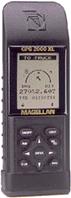
- Magellan GPS 2000XL: This is a slightly larger unit which
is waterproof, field ruggedized with wraparound rubber armoring,
and scratch-proof display. The GPS 2000 XL receiver stores 200
waypoints. This unit offers NMEA data output for PC communication.
The battery life is about 24 hours for 4 AA batteries. Weight
is 10 ounces. Cost is approximately $150.
- Magellan Blazer 12: This is a small, lightweight, and
waterproof unit that stores 100 waypoints. Battery life on this
receiver is about 20 hours for 2 AA batteries. No NMEA data output.
The Blazer 12 shares the same receiver and quadrifilar antenna
with the other Magellan 300 series receivers; however the user
interface menus, number of waypoint, the availably of NMEA ports,
and many other features vary. The accuracy of other 300 series
receivers should be similar to the Blazer. Weight is 6.8 ounces.
The cost of the Blazer12 is approximately $110.
No testing of the NMEA 0183 output to personal computers was made.
Test Network and Survey Station Data:
Forested Site: The Clackamas Test Network is located in Western
Oregon on the Mt. Hood National Forest. Clackamas GPS Test Network
is a site for testing P and C/A Code (resource grade) GPS receiver
performance under moderate to heavy western Oregon timber canopy.
The vegetation at the site consists of Douglas Fir and Western Hemlock
over story, these trees are approximately 24-40" d.b.h., with
a Vine Maple and Red Alder under story. The terrain at the site
is nearly flat with no terrain obstructions above 20 degrees. The
test network is composed of twelve points with known geographic
positions. These twelve points were established by a conventional
Total Station closed traverse survey which was based on two GPS
points adjacent to the site which had reasonable satellite horizon.
These two points were established by static carrier phase GPS survey
connected to the Oregon High Accuracy Reference Network (HARN).
Open Site: The station "Estacada" was used as a control
site due to its clear-sky nature with no obstructions. Station "Estacada"
is an Oregon High Accuracy Reference Network (HARN) Order A survey
mark established by the National Geodetic Survey in 1998, PID-AI1994.
The station is 487 KM, N 47 W of the Clackamas Test Network site.
Field Data Logging Procedures:
All GPS observations were made at approximate antenna height of
1.5 meters.
Clackamas site:
- Waypoints were logged at 1 position per point for the 12 points
in the Clackamas network this was repeated a second time for a
total sample of 24 positions.
- For the Garmin GPS III Plus both 1 second and 60 second waypoints
were logged. This was the only one of the receivers tested that
allowed multiple positions to be averaged for waypoints. (see
Figure 1: Garmin III Plus 60s).
Estacada control point:
- Waypoints were logged at 1 position per point for 5 observations
of the station Estacada.
- For the Garmin GPS III Plus both 1 second and 60 second waypoints
were logged for the same 5 observations.
Office Data Processing Procedures:
The data analysis was made using Microsoft Office 2000 Excel spreadsheet
application.
All accuracies report at 2DRMS (see appendix 1 for formulas). The
2DRMS value closely approximates the 95% error for a position. In
other words, 1 out of 20 measurements will have errors larger than
those published in this report.
All data was analyzed in the North American Datum of 1983 (NAD
83).
SITE CONDITIONS:
These tests were made under dry conditions.
TEST RESULTS:
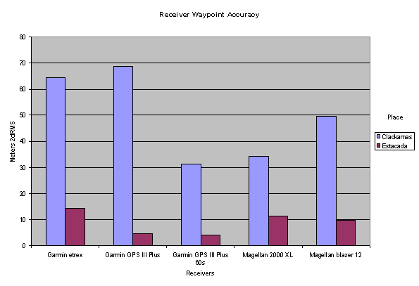
Conclusions on Recreation GPS receivers:
- Accuracy performance in open sites is acceptable for mapping
and GIS applications.
- A significant decrease in accuracy performance in forested sites
was observed. Accuracy in forested sites is not acceptable for
mapping and GIS applications. (see discussion of National Map
Accuracy Standards below)
- The ability to log multiple observation waypoints offers increased
accuracy for forested sites. The accuracy of the average of 60
positions made with the Garmin GPS III was not accurate enough
for GIS applications at 31 meters.
- The efficiency observed for all receivers approached 100% even
at forested sites. It appears that the PDOP and SNR settings for
these receivers, which are not user configurable, are set to allow
maximum data logging in adverse canopy conditions. These configurations
allow "noisier" data to be logged therefore the high
errors under canopy.
The National Map Accuracy Standard (NMAS 1974) for point positions
on 1:24,000 Scale Quadrangle maps is 12.2 meters at 90% or to put
it in the same confidence interval as our study 14.8 meters at 95%.
Therefore these receivers when used in open sites meet national
map accuracy standards. When operating under tree canopy these receivers
do not meet national map accuracy standards.
Appendix A: Accuracy computation formulas used in this paper.


|