 |
 |
 |
 |


|
By Santiago Mancebo and Ken Chamberlain
|
 |
Introduction:The Trimble Navigation Pathfinder Pro XR is a 12 channel Global Positioning System (GPS) receiver. This receiver was tested by the U S Forest Service to determine performance under Western Oregon tree canopy conditions. The tests were made between June 7 and 22, 2000. The GPS receiver performance tests were made at two sites: one under Western Oregon forest canopy at the Clackamas Test Network and another at the open-sky National Geodetic Survey control station "Estacada". All tests were made with Selective Availability (SA) off. The tests were designed to examine the effect of tree canopy on the following: |
1) The positional accuracy of various lengths of data logging from 1 second to 120 seconds to determine what, if any, increases in accuracy occur through the averaging of increasing numbers of positions.
2) The differences in positional accuracy for the following types of Pathfinder Pro XR data: a) uncorrected, b) real-time differentially corrected, c) real-time data which was then post processed, and d) post-processed differentially corrected.
3) The accuracy the Pathfinder Pro XR using various differential correction methods at different receiver settings of Signal-to-Noise (SNR) and Position Dilution of Precision (PDOP).
4) The efficiency of receiver performance. That is the number of positions logged during a specific period divided by the number of possible positions expressed as a percentage.
Equipment:
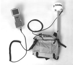
This test was performed with both the Pathfinder Pro XR version
3.24 using the manufacturers standard equipment integrated GPS and
DGPS radio beacon antenna. The TSC1 data collector was used with
the Asset Surveyor version 4.3 Software.
The manufactures list price is $10,995, the GSA price for the Pathfinder
Pro XR is $10,005.
Test Network and Survey Station Data:
Forested Site: The Clackamas Test Network is located in Western Oregon on the Mt. Hood National Forest. Clackamas GPS Test Network is a site for testing P and C/A Code (resource grade) GPS receiver performance under moderate to heavy western Oregon timber canopy. The vegetation at the site consists of Douglas Fir and Western Hemlock over story, these trees are approximately 24-40" d.b.h., with a Vine Maple and Red Alder under story. The terrain at the site is nearly flat with no terrain obstructions above 20 degrees. The test network is composed of twelve points with known geographic positions. These twelve points were established by a conventional Total Station closed traverse survey which was based on two GPS points adjacent to the site which had reasonable satellite horizon. These two points were established by static carrier phase GPS survey connected to the Oregon High Accuracy Reference Network (HARN).
Open Site: The station "Estacada" was used as a control site due to its clear-sky nature with no obstructions. Station "Estacada" is an Oregon High Accuracy Reference Network (HARN) Order A survey mark established by the National Geodetic Survey in 1998, PID = AI1994. The station is 48 KM, N. 47 degrees W. of the Clackamas Test Network site.
Real-Time Beacon: The real-time differential corrections were received from the USCG DGPS Continuously Operating Reference Station "Appleton". This station is located 97 KM, N 26 degrees E from the Clackamas Test Network. The receiver at station Appleton is an Ashtech Z-XII3. The RTCM type 9-3 differential correction message is broadcast at 300 kHz at 100 bits/second from a 300 ft high radio antenna. The National Geodetic Survey PID = AC9141.
Reference Station: The post-processed differential correction base (reference) data was downloaded from the Community Base Station (CBS) at the Portland State University Geology Department in Portland, Oregon. The Portland State University CBS uses 12 channel Trimble Maxwell chip receiver recording SYNC measurements at 5 second intervals at a 10 degree elevation mask with Trimble CBS software version 2.67. This CBS is located approximately 84 Km from the Clackamas Test Network.
Field Data Logging Procedures:
All GPS observations were made at approximate antenna height of 1.8 meters.
All GPS data was logged at 1 position / second.
The Elevation Mask was set at 15 degrees.
Clackamas site:
- Data was logged for 120 positions at each of the 12 points allowing a maximum occupation time of 10 min.
- Data was logged with the PDOP set to 100 for all tests.
- The complete network positions were logged 3 times with the SNR set at 4, 5, and 6.
- The complete network was logged with real time corrections and again without corrections.
Estacada control point:
- Data was logged for 1 hour.
- Data was logged with the PDOP set to 100 for all tests.
- Data was logged at SNR 6.
- The data was logged with real time corrections Apply real-time "auto" (Asset Surveyor v5.1+ setting Real Time input preferred = "Integrated beacon corrections") and again without corrections Apply real-time "off" (Asset Surveyor 5.1+ Real Time input preferred = "Use uncorrected GPS").
Office Data Processing Procedures:
Data post processed using the Trimble Pathfinder Office version 2.51 software package. Post-processing consisted of Differential corrections (MCOR400) of the raw (.ssf) receiver files using the Portland State University CBS. The corrected (.cor) files were then exported in database .dbf format.
The data analysis was made using the Microsoft Office 2000 Excel spreadsheet application. Excel was used to filter the PDOP. The data was filtered to create separate data sets for PDOPs 4, 6, 8, 10, 12, 15, 20 and 100 all further analysis was made using these data sets.
All accuracies report at 2DRMS (see appendix 1 for formulas). The 2DRMS value closely approximates the 95% error for a position. In other words, 1 out of 20 measurements will have errors larger than those published in this report.
All data was analyzed in the North American Datum of 1983 (NAD 83).
SITE CONDITIONS:
These tests were made under generally dry conditions ranging from
light rain to dry. No attempt was made to quantify canopy moisture.
Guide to abbreviations used in Figures 1 - 7:
Forest: Refers data from the Clackamas Test Network.
Open: Refers to data from the station Estacada.
Forest - None: Refers to Clackamas Test Network site data without
differential Correction.
Open - None: Refers to station "Estacada" open site data
without differential Correction.
Forest - RT: Refers to Clackamas Test Network site data with real-time
broadcast differential Corrections.
Open - RT: Refers to station "Estacada" open site data
with real-time broadcast differential Corrections.
Forest - RT & Post: Refers to Clackamas Test Network site data
with real-time broadcast differential Corrections which were then
post-processed (PPRT).
Open - RT & Post: Refers to station "Estacada" open
site data with real-time broadcast differential Corrections which
were then post-processed (PPRT).
Forest -Post: Refers to Clackamas Test Network site data post-processed
from raw data without real-time broadcast differential corrections.
Open - Post: Refers to station "Estacada" open site data
post-processed from raw data without logging real-time differential
corrections.
Note: The manufacturers recommended settings for the Pathfinder
Pro XR are: Signal to Noise (SNR) of 6 and a Position Dilution of
Precision (PDOP) of 6. Typically when the SNR gets smaller the signal
is "noisier" thus decreasing the accuracy and when the
PDOP increases the satellite geometry used for determining the GPS
position becomes weaker thus decreasing the accuracy .
TEST RESULTS:
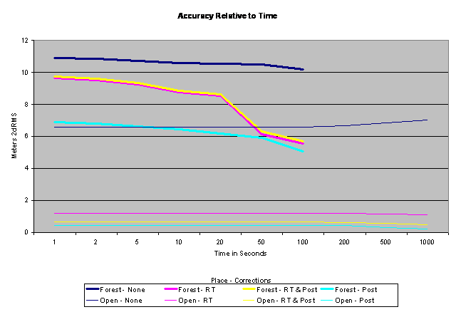
Figure 1: The graph shows the GPS accuracy relative to length of occupation for uncorrected data and various correction methods at both the Estacada and Clackamas Sites.
Test 1 Discussion:
This data reflects a running average of all positions at each location for each receiver configuration.The data indicates that the manufacturers default of 3 positions is sufficient.
For the open site (Estacada) there was no increase in accuracy
for the longer occupation times.
For the forested site (Clackamas) the data logged with real-time
corrections and data logged with real-time corrections which was
then post processed rapidly increased in accuracy until about 50
positions were recorded after that the increase in accuracy was
gradual.
For the forested site (Clackamas) data logged with no real-time
corrections which was then post-processed was the most accurate
for short observations. It showed a slight gain in accuracy over
time.
Open sites:
- 3 Positions of data is sufficient.
Forested Sites:
- For point features 3 positions of data is sufficient for post-processed data that was logged without real-time corrections.
- For point features 50 positions of data is recommended for data logged with real time corrections which are subsequently post processed.
Test 2. Examine the differences in positional accuracy for
the following types of Pathfinder Pro XR data: 1) uncorrected ,
2) real-time differentially corrected, 3) real-time data which was
then post processed, and 4) post-processed differentially corrected.
Both 1 second data sets and 50 second data sets were used.

Figure 2: This graph shows the accuracy of various receiver
configurations at the open-sky station Estacada for one second of
data at various PDOP settings.
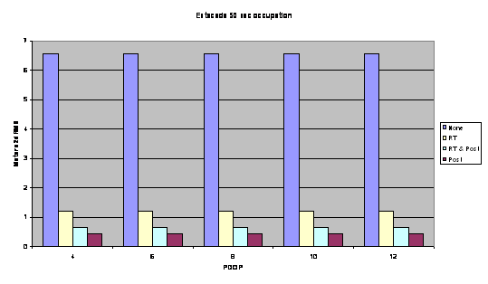
Figure 3: This graph shows the accuracy of various receiver
configurations at the open-sky station Estacada for 50 positions
of data at various PDOP settings.
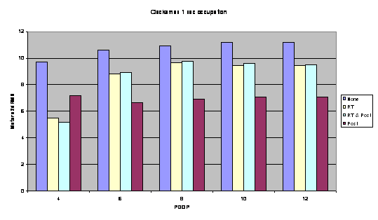
Figure 4: This graph shows the accuracy of various receiver
configurations at the forested Clackamas Test Network for 1 second
of data at various PDOP settings.
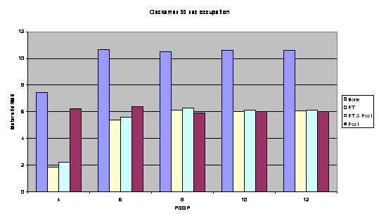
Figure 5: This graph shows the accuracy of various receiver
configurations at the forested Clackamas Test Network for 50 positions
of data at various PDOP settings.
Test 2 Discussion:
This test examined the differences in positional accuracy for the following types of Pathfinder Pro XR data: 1) uncorrected , 2) real-time differentially corrected, 3) real-time data which was then post processed, and 4) post-processed differentially corrected.
The removal of SA from the C/A code GPS signal prompted field users to ask whether uncorrected data was accurate enough for GPS mapping purposes. This test indicates that differential correction is recommended for all data.
PDOP was not a factor at open sites as all data collected was at or below PDOP 6; SNR also was not a factor as all data collected was higher than SNR 6.
Absolute accuracy at the forest site will be examined in the next tests due to variables of SNR not accounted for in this test. This data is intended to only illustrate the relative accuracy of different correction methods and receiver configurations.
The data on figure 2 indicates that the open site (Estacada) 1 second data which was real-time corrected had about 1 meter accuracy. Sub-meter accuracy was achieved by both data collected without corrections which was then post-processed and data collected with real-time correctors which was then post-processed.
The open-site (Estacada) data on figure 3 verifies the results of test 1 showing that there is no change in accuracy for longer occupation times.
The forested-site (Clackamas) data on figure 4 shows a significant gain in accuracy between the data that was logged with no corrections then post processed however, the data that was logged with real-time correctors then post-processed showed very little increase in accuracy.
The results shown in figure 5 for the forested-site (Clackamas)
data that was logged with no corrections then post processed have
similar accuracy to figure 4 however, the 50 positions of data logged
with real-time correctors then post-processed was significantly
more accurate than the 1 second data.
Test 2 Recommendations:
Open sites:
- Real-time or post-processed differential corrections are recommended for all data.
- Post-processing of real time corrected data is optional.
Forested Sites:
- Real-time or post-processed differential corrections are recommended for all data.
- For point features 3 positions can be used when data is logged with real-time corrections "OFF".
- For point features logged with real-time corrections "ON" should contain 50 positions of data.
- Post-processing of real time corrected data is optional.
Test 3: Examine the accuracy the Pathfinder Pro XR using
various differential correction methods at different receiver settings
of SNR and PDOP.
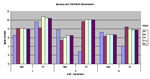
Figure 6: This graph shows the differentially corrected accuracy
of various correction configurations with 1 second of data using
different combinations of PDOP and SNR settings at the forested
Clackamas Test Network.
Test 3 discussion:
The data presented on figure 6 may be examined for absolute accuracy
at various receiver settings and correction methods.
The accuracy data shown on figure 6 should be examined with the
efficiency data shown in figure 7. For data logging at forested
sites it is often necessary to make trade offs between accuracy
and efficiency. See test 4 discussion for conclusions on receiver
settings and correction methods.
Test 4: Report on efficiency of receiver performance. That
is the number of positions logged during a specific period divided
by the number of possible positions expressed as a percentage.
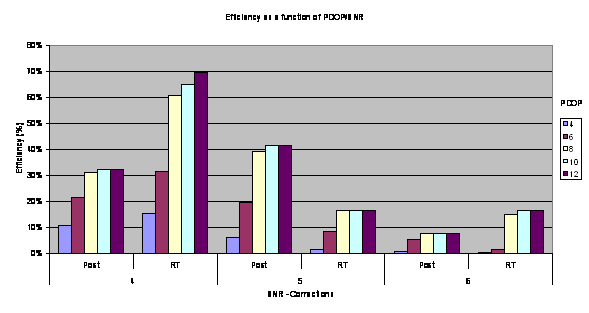
Figure 7: This graph presents the efficiency of various receiver
configurations. using different combinations of PDOP and SNR settings
at the Clackamas Test Network.
This data was difficult to interpret. The SNR 4 data shows and the
real-time data being more efficient than post-processed however
for SNR 5 the reverse is shown. The data for SNR 6 should be considered
to be equally efficient because of the smaller data set in this
sample.
GPS users should use the accuracy and efficiency information show on figures 6 and 7 to determine the receiver settings and correction method most appropriate to the accuracy requirements of their project. High accuracy will data will be less efficient to log than lower accuracy data.
Test 3 and 4 discussion:
Efficiency and accuracy need to be discussed together because of
their interrelated effects on each other. For example, data that
is highly accurate may be very inefficient and highly efficient
data may lack in accuracy. Finding a balance between accuracy and
efficiency is user and project dependent. Only general observations
can be made from this data.
Test 3 and 4 Recommendations:
For Forested sites:
- For production work where the highest attainable accuracy is not a consideration receiver settings of PDOP 8 and SNR 4 are recommended. This configuration clearly is the most efficient with accuracy that is relatively good.
- Where the highest accuracy is required and efficiency (time) is less of a consideration receiver settings of PDOP 6 and SNR 5 are recommended. Accuracy will be high but it will take a long time to log the data.
- For the highest accuracies and efficiency it is recommended that the receiver NOT be configured to record real time corrections.
Recommendations for the Pathfinder ProXR:
The following are general recommendations for using this receiver for mapping applications. The data presented in this report should be examined to determine the receiver settings, occupations length, and correction methods most appropriate for each project considering accuracy, efficiency and field operation requirements.
Differential Corrections are recommended for all data.
Open sites:
- Point features can consist of 3 positions per feature.
- The manufacturers recommended receiver settings PDOP 6 and SNR 6.
- Real-time or post-processed correction methods can be used.
- Sub-meter accuracy can be achieved using data logged without real-time corrections that is post-processed.
Forested sites:
- Point features logged without real-time corrections then post processed should use 3 positions per feature.
- For point features logged with only real-time or real-time corrections that are post-processed 50 positions are recommended.
- For production work where the highest attainable accuracy is not a consideration receiver settings of PDOP 8 and SNR 4 are recommended. This configuration clearly is the most efficient with accuracy that is relatively good.
- Where the highest accuracy is required and efficiency (time) is less of a consideration receiver settings of PDOP 6 and SNR 5 are recommended. Accuracy will be high but it will take a longer to log the data
General map accuracy considerations:
The National Map Accuracy Standard (NMAS 1947) for point positions
on 1:24,000 Scale Quadrangle maps is 12.2 meters at 90% or to put
it in the same confidence interval as our study 14.8 meters at 95%.
Therefore this receiver when used as recommended above meets national
map accuracy standards when operating under tree canopy.
Appendix: Accuracy computation formulas used in this paper.

