|
 |
 |
 |


|
By Santiago Mancebo and Ken Chamberlain
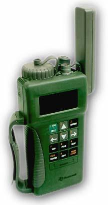
Equipment:This test was performed with the Rockwell PLGR+ 96 using the manufacturer standard equipment internal antenna. The manufactures list price is $3,500. This unit is manufactured by Rockwell Collins. The PLGR+ 96 SW = 613-9898-013, HW = 1E11 was used for all tests. Test Network and Survey Station Data:Forested Site: The Clackamas Test Network is located in Western Oregon on the Mt. Hood National Forest. Clackamas GPS Test Network is a site for testing P and C/A Code (resource grade) GPS receiver performance under moderate to heavy western Oregon timber canopy. The vegetation at the site consists of Douglas Fir and Western Hemlock over story, these trees are approximately 24-40" d.b.h., with a Vine Maple and Red Alder under story. The terrain at the site is nearly flat with no terrain obstructions above 20 degrees. The test network is composed of twelve points with known geographic positions. These twelve points were established by a conventional Total Station closed traverse survey which was based on two GPS points adjacent to the site which had reasonable satellite horizon. These two points were established by static carrier phase GPS survey connected to the Oregon High Accuracy Reference Network (HARN). Open Site: The station "Estacada" was used as a control site due to its clear-sky nature with no obstructions. Station "Estacada" is an Oregon High Accuracy Reference Network (HARN) Order A survey mark established by the National Geodetic Survey in 1998, PID-AI1994. The station is 487 KM, N 47 W of the Clackamas Test Network site.Field Data Logging Procedures:All GPS observations were made at approximate antenna height of 1.5 meters. The receiver was pole mounted at the Clackamas site and tripod mounted at the Estacada site. All GPS data was logged at 1 position / 2 seconds. GPS positions ported in National Marine Electronics Association NMEA - 183 format to a notebook personal computer running VisualGPS software by Appolocom. All data was logged with the receiver was set with WAGE (Wide Area GPS Enhancements) on. The receiver with WAGE on processes enhanced clock correction signals from the satellites. All data was logged with an elevation mask of 15 degrees.
Estacada control point:
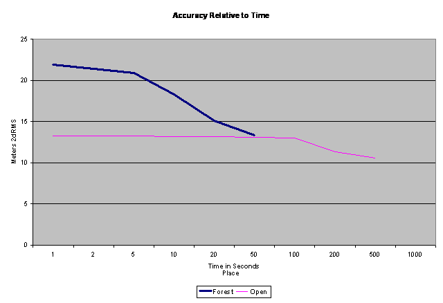
Office Data Processing Procedures:The data from the NMEA stream was converted from decimal degree format to Degree-minute- second format in Microsoft Excel then exported to Geographic Calculator for conversion to NAD 83 State Plane Coordinates (SPC), Oregon North Zone. The SPC coordinates were imported into Microsoft Excel. Excel was used to compare the GPS waypoints to the true point coordinates, calculate statistics, and compute efficiency. All accuracies report at 2DRMS (see appendix 1 for formulas). The 2DRMS value closely approximates the 95% error for a position. In other words, 1 out of 20 measurements will have errors larger than those published in this report. All data was analyzed in the North American Datum of 1983 (NAD 83). SITE CONDITIONS: These tests were made under dry conditions ranging. No measurements of canopy moisture were made. Test 1. Examine the accuracy of various lengths of data logging at forested and open sites
Open site accuracy with 1 second of data was 13.3 meters 2dRMS. Forested site (Clackamas) accuracy after 1 second of data was 21.8 meters 2dRMS Forested site (Clackamas) accuracy after 50 positions of data was 13.4 meters 2dRMS. For open site (Estacada) there was little or no increase in accuracy for longer occupation times up to 100 seconds then a slow increase in accuracy. For the forested Clackamas Test Network accuracy increased when 50 positions were logged.. 802 positions were logged at forested Clackamas Network of these 48 were deleted due to very high errors. 1543 positions were logged at the open site (Estacada), of these none were deleted. Logging of 50 positions at forested sites appears to provide enough
data to detect outlier positions. Test 1 Recommendations: Open sites:
Forested sites:
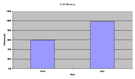 Figure 2: This graph presents the efficiency of the PLGR at the forested Clackamas Test Network and the open-sky station "Estacada". Test 2 Discussion: Open site (Estacada) efficiency is 100%. Forested site (Clackamas) efficiency is 60%. Recommendations for data logging with PLGR:Open sites:
Forested sites:
The National Map Accuracy Standard ( NMAS 1947) for point positions on 1:24,000 Scale Quadrangle maps is 12.2 meters at 90% or to put it in the same confidence interval as our study 14.8 meters at 95%. Therefore this receiver when used as recommended above meets national map accuracy standards when operating under tree canopy. Appendix: accuracy computation formulas |