Chamberlain, Land Surveyor; Santiago Mancebo, Graduate Student USFS
Volunteer; Don Patterson, Land Surveyor; and Tony Jasumback, GPS
Consultant
ROUGH DRAFT
Table of Contents
Comparison of GPS Receivers Under a Forest
Canopy with Selective Availability Off
Tests - Summer 2000
SA-off
On May 1st President Clinton announced that Selective Availability
(SA) would be turned off effective midnight May 1, 2000. This degradation
feature Selective Availability (SA) is the intentional degradation
of the Global Positioning System (GPS) signals. This will mean that
civilian users of GPS will be able to pinpoint locations up to ten
times more accurately than before. With SA off position accuracy in
the autonomous mode increased from +/- 100 meters to less than +/-
10 meters (see Figure 1). The decision to discontinue SA is the latest
measure in an on-going effort to make GPS more responsive to civil
and commercial users worldwide. Last year, Vice President Gore announced
plans to modernize GPS by adding two new civilian signals to enhance
the civil and commercial service.
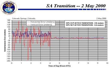
Figure 1. The change in position error when SA turned off
Test courses
Powell, Idaho GPS test course
This GPS test site is located on the Powell RD on the Clearwater
NF. It is located on Highway US 12 near the Idaho Highway Maintenance
area about 12 miles west of Lolo Pass and about 55 miles SW of Missoula,
MT. The test site is located near the Lochsa River, and has mountains
on the north and south sides of the course, with a obstructed angle
of 10 degrees on those two sides. The canopy consists of large (24"-42"
d.b.h.) old growth Cedar and Spruce trees in a flat valley bottom
with only a small amount of understory and would be considered a
heavy canopy at most of the stations. The course has 11 turning
points or stations, making a polygon measuring 12.019 acres in size
that can be divided to produce 2 areas (see Figure 2).
The ground survey traverse and geodetic control survey of the Powell,
ID GPS test course was done by R-1 engineering and the Cadastral
Survey group, Lolo N.F for MTDC. The conventional survey was accomplished
with a Topcon total station. The GPS control survey was accomplished
with four Trimble 4000SSE/SSI geodetic GPS receivers with L1/L2
compact dome geodetic antennas operating in the static mode. Three
data sets were observed from HARN (High Accuracy Reference Network)
stations "LOLO GPS" and "W522". Final results were calculated from
a least squares adjustment utilizing fixed integer baselines from
the geodetic observations. GEOID99 model was used for geoid separation
estimates. The error estimates for the network observations are
in the 2-centimeter range. Coordinates are NAD83 (1992) Montana
HARN Latitude, Longitude.
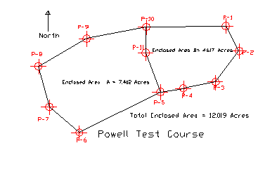
Figure 2. Site Diagram for Powell GPS test course
Lubrecht Test Course
The Lubrecht Test Course is located at the Lubrecht Experimental
Forest about 30 miles NE of Missoula, MT. This course is a polygon
with seven turning points (stations) and is located on gentle terrain,
under a mixed Lodgepole and Ponderosa Pine canopy. The trees are
about 19 meters tall with a minimal understory and would probably
be classified as a light to medium canopy. Station B-31 is located
in the open, with a clear view of the sky down to an angle of 15
degrees (See Figure 3).
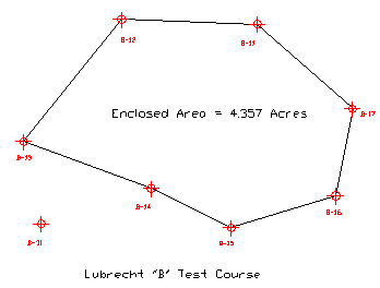
Figure 3. Site Diagram for Lubrecht GPS Test Course
Clackamas test course
The Pacific Northwest Regional Surveyor established a test course
at the request of the Forest Service's GPS Steering Group in a typical
dense West Coast Douglas-fir stand. The course is on gentle terrain
in a second growth Douglas-fir and western hemlock overstory (trees
approximately 24 to 40 inches d.b.h.) with a vine maple and red
alder understory. It consists of 13 stations, all accurately located
within 0.05 meters. The area enclosed by the traverse can be varied
from 2.19 to 7.20 acres, depending on the stations chosen (see Figure
4).
The Test Network geographic positions were established by GPS and
conventional geodetic survey. These thirteen points are used to
define five areas, which range from 2.19 to 7.20 acres. Geographic
positions for the network points are accurate to 5 cm. Each point
is monumented with 5/8" rebar with plastic caps and a nearby orange
carsonite fence post, with "survey monument" sticker attached. All
points are intervisible and the lines between the survey points
are brushed and flagged.
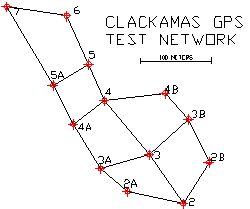
Figure 4. Site Plan for Clackmas GPS Test Course
Test procedure
The receivers were turned on and allowed to collect data for approximately
20 minutes to insure that a current almanac was stored in the receiver
before the tests were run. External antennas were used on all receivers
for most of the tests. Some tests were run with the built-in internal
antennas to obtain a comparison between the 2 types of antennas.
Different numbers of positions (1, 60, and 120) were averaged at
the different stations to determine what affect that had on the
accuracy. When possible the PDOP (Precision Dilution of Precision)
and EPE (Estimated Position Error) values were monitored to determine
what type of constellation was being accessed by the receivers.
The position errors obtained at each station were then averaged
over the complete course to determine the average error of the individual
receiver.
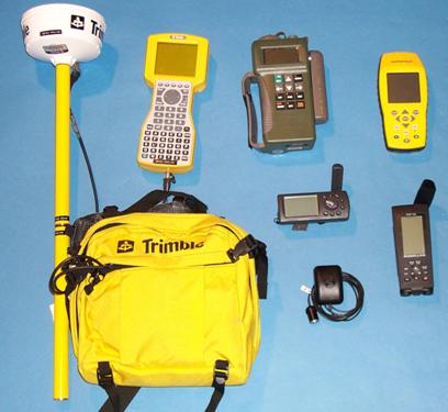
Receivers tested
The receivers tested on the Lubrecht and Powell courses were:
1. Rockwell PLGR-96, PPS, S/N 165268, with sw:613-9868-015 Software.
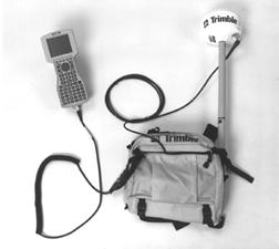
2. Trimble Pro XR, S/N 0220174140 with TSC1, and Asset Surveyor
Ver. 5.00 software.
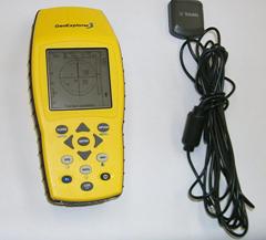
3. Trimble GeoExplorer 3, S/N 0330040826, with Ver. 1.02 Firmware.
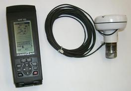
4. Magellan Map 410 Receiver Ver. 1.05 Firmware
5. Garmin GPS III, S/N 92113388, 2.05 Firmware
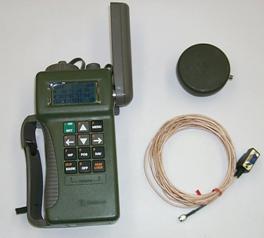 |
The Rockwell
PLGR+96 FED is a five-channel, single-frequency Precise
Positioning System (PPS) P(Y) Code receiver with built-in antenna.
It has been evaluated in other MTDC reports and the accuracy
of the receiver hasn't changed significantly with S/A turned
off. The receiver contains a security module that can eliminate
the positional error intentionally introduced when selective
availability (SA) was enabled and it decodes the encrypted signal,
which prevents its unauthorized use, called anti-spoof (AS).
The receiver is not classified, but it is an accountable property
item and should remain in control of the authorized user. It
can store 999 waypoints and has 15 user definable reversible
routes that can have up to 25 legs each. It has an external
power and antenna option. It is DGPS ready. |
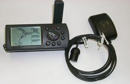 |
The Garmin
GPS III is a Differential-ready 12 parallel channel receiver
that continuously tracks and uses up to twelve satellites to
compute and update a position. It has acquisition Times of,
approx. 15 seconds warm and approx. 45 seconds cold. It has
a continuous update rate of 1 second. It can store 500 waypoints
with symbols and 20 reversible routes, and a track log of 1900
points. It has a built-in detailed basemap that covers lakes,
rivers, interstates, national/state highways, secondary roads
in metro areas, cities, railroads, airports and a detailed exit
database for the Federal Highway system). More detailed maps
are an option. It has 106 different map datums. It has a NMEA
0183 and RTCM 104 DGPS corrections interface. It has an optional
external antenna. |
 |
The Trimble
Pro XR is a 12-channel, real-time differential GPS receiver
with an integrated antenna. The antenna receives the GPS signal
and the real-time differential corrections broadcast by a radio
beacon maintained by the U.S. Coast Guard or the U.S. Army Corps
of Engineers. The operator can select if DGPS is to be used
and which real-time broadcast station to use. It is capable
of outputting both the real-time differentially corrected position
as well as the raw data for each position. Data were collected
using the Trimble System Controller (TSC1) data logger with
Asset Surveyor Software Version 5.00 The data collection interval
was set at 1 second, with the PDOP and SNR masks set at 6, and
the elevation mask set at 15. Pathfinder Office Software Version
2.70 was used to differentially post process the raw-position
data and display both the post processed and real-time-corrected
position data. Base-station data for post processing were obtained
from the Forest Service base station in Missoula for the Powell
and Lubrecht Site. (http://www.fs.fed.us/database/gps/missoula.htm).
That station, was a About 30 miles from the Lubrecht Site and
about 55 miles from the Powell test site, and records data at
5-second intervals. |
 |
The Trimble GeoExplorer
3 receiver is small in size, and its portability and powerful
features make the GeoExplorer 3 an ideal tool for creating and
maintaining utility, urban and natural resource asset databases.
It has an integrated, high-performance 12-channel GPS receiver
and antenna. The receiver firmware provides for easy GIS data
collection, easy data maintenance of existing GIS databases,
cable-free real-time differential GPS with Beacon-on-a-Belt
receiver and it provides ARC/INFO, AutoCAD, Intergraph, MGE,
ERDAS and GRASS support. GPS Pathfinder Office software is included
for data processing and GIS export. |
 |
The Magellan Map 410
is a 12 parallel-channel receiver with a detachable signal-sensitive
antenna. It has a built-in worldwide background map and detailed
basemap for the Americas includes cities, lakes, rivers, railroads,
coastlines, interstate, national and state highways. It has
a built in altimeter. It can store 500 waypoints and 20 routes
with 30 legs. It automatically averages your position when the
receiver is stationary. It has 9 graphic navigation screens,
a re-settable trip odometer, and "EZstart" initialization and
built-in simulator for training and education. It has Upload/Download
Capability, has NMEA output and is DGPS ready. It has external
antenna capability. |
Results
Most error results shown in the following charts may be expressed
in 2DRMS values. The 2DRMS value approximates the 95% probability
of error for a position. This means that 95% of the time or 19 out
of 20 position readings will have an error less that what is shown
on the charts. The formula used in the calculation of 2DRMS is:
2DRMS=2x((Mean Error)2 +(Standard Deviation of Error)2)0.5
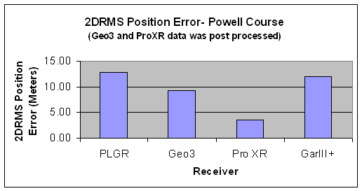
Figure 5. Chart shows the position error in 2DRMS, (95% of the time
the error will be less than shown), for the different receivers on
the Powell GPS test course. (120 records averaged).
The chart in figure 5 shows the position errors for the different
receivers on the Powell test course. The Trimble Pro XR and Geo 3
receivers collected files that could be post-processed and those files
were post-processed in figure 5. The error over the course with the
Pro XR was often less than 2 meters under the forest canopy. Figure
6 shows position errors for the different receivers on the Lubrecht
test course and the Trimble Pro XR and Geo 3 were not corrected or
post-processed is this graph. The position errors for the Trimble
Pro XR and Geo 3 receivers are more similar to the other receivers
compared to figure 5 because of the uncorrected or non-post processed
data. Most position errors were less than 7 meters for all receivers
except for the Magellan receiver.
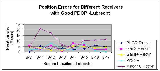
Figure 6. This graph shows the position errors at the different stations
for the Lubrecht GPS test Course. In this graph the Pro XR and Geo
3 were not post-processed. (60 record average).
Station 31 is in the open and not under a forest canopy. As can be
seen in figure 6, all of the receivers have position errors of less
than 5 meters. If all the position records are averaged for all the
stations on the course, an overall position error can be determined
for each receiver over the complete GPS test course. This is shown
in Figure 7.
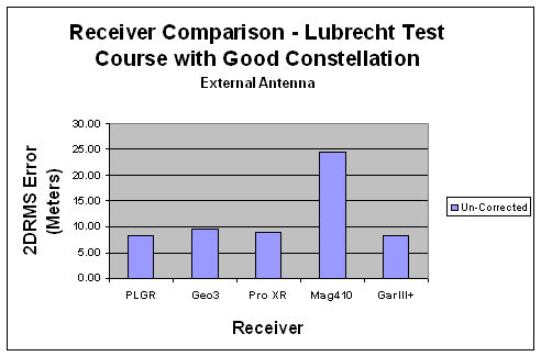
Figure 7. This graph shows the position error for each of the receivers
on the Lubrecht GPS test Course. In this graph, all position error
records for each receiver, shown in figure 6, were averaged for each
station. The position errors for each receiver, on all stations, on
the whole course were then averaged to obtain an overall position
error for each receiver.
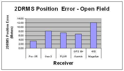
Figure 8. This graph shows the position error for each of the receivers
at an open point (no canopy), near the MTDC office. In this graph,
the position error was obtained by calculating an average position
error for each of the different record sizes (1, 60, and 120 records)
in the open. The 2DRMS value was then calculated from those values
for each of the receivers.
Post-processing
As previously mentioned, the only receivers that collected data
that could be post processed were the Geo 3 and the Trimble Pro
XR. Figure 9 and 10 show the results of post processing data from
those receivers for the different number of records averaged.
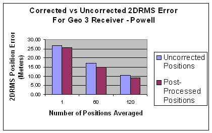
Figure 9. This graph compares the 2DRMS position error for the Trimble
Geo 3 receiver when a different number of records are averaged.
The files were post-processed and also displayed on this graph.
It shows the potential for large errors if only a few positions
are averaged.
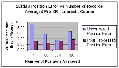
Figure 10. This graph compares the 2DRMS position error for the
Trimble Pro XR receiver when a different number of records are averaged.
RT indicated real-time corrected positions. The files were post-processed
and also displayed on this graph. Why the large error occurred for
the 120 record average-uncorrected is unexplainable, but it shows
how much of that error was removed by post processing.
Effect of SNR on position accuracy
Figure 11 shows the effect of different SNR (Signal to Noise Ratio)
values to position accuracy. As SNR increases so does the accuracy.
However, setting the minimum SNR value to a larger value, will normally
cause the efficiency of data collection to go down. The higher SNR
values usually will require waiting at positions for a longer period
of time before the stronger signals will be available to the receiver.
Mancebo and Chamberlain have a more detailed discussion of the SNR
vs data collection efficiency in another paper.
Figure 11. Graph showing the effect of SNR on position accuracy
under canopy and in the open for 1 and 50 position records.
Effect of PDOP on Position accuracy
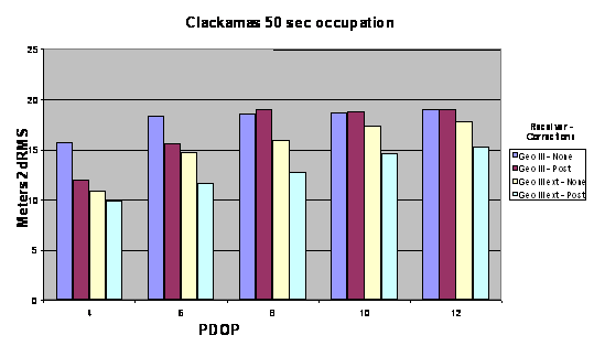
Figure 12: This graph shows the accuracy of various receiver configurations
at the forested Clackamas Test Course for 50 seconds of data at
various PDOP settings.
As can be seen from figure 12, the accuracy will decrease as PDOP
increases. This data was collected on the Clackamas Test Course
with the GeoExplorer 3 receiver. The effect of post-processing is
also displayed in this graph. Post-processed data collected with
a PDOP of 12 was more accurate than uncorrected data with a PDOP
of 4.
Effect of using external antennas on the
receivers
All but the Trimble Pro XR have internal antennas. In the open,
under no tree canopies, the internal antennas are usually adequate.
However under the forest canopy, external antennas can give better
accuracies. Figure 13 is an example of the improved results for
the Garmin GPS III+. The results will differ for the different receivers
but the external antennas are more sensitive and are usually placed
on a range pole higher than the operator's head thereby reducing
signal blockage.
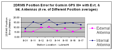
Figure 13. This graph shows the effect of using an internal and
external antenna and the effect it has on 2DRMS position accuracy.
These values obtained for the different stations are calculated
from the different number of position averaged.
PLGR better in canopy
The PLGR acquires positions better in canopy than the C/A code receivers.
This is possibly due to the fact that the P(Y) code chipping rate
(The frequency at which the P code chip code is transmitted) is
an order of magnitude higher than the C/A code. Under an open canopy
the accuracy may not be as good as some of the C/A code but is comparable
under the canopy. The major advantage to the receiver is that it
is simple to use and the data acquisition is much more efficient.
However as shown in a later, figure 16, if a poor constellation
is being used to calculate a position, a larger position error is
obtained.
Real time vs post processed
Real-time positions or DGPS positions are positions that are corrected
real time, with correction signals sent to the receiver from a beacon
DGPS station or via Satellite from a network of ground stations.
These signals are received and the data corrected real-time. Post
processing real-time data doesn't significantly increase the position
accuracy most of the time but usually does improve it. The
down-side
to real time data collection is that sometimes the correction
signal is interrupted or is
attenuated
. If the files are collected and brought back to the office, it
is usually quicker and more efficient to post process the data later
at the office. Figures 14 and 15 show the position error results
of Real-Time (DGPS) and post processing data.
 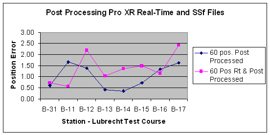
Figure 14. This graph shows the effect of post-processing un-corrected
data (ssf) files and post processing real-time corrected data
(all data was processed).
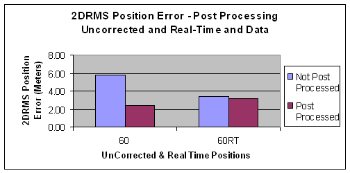
Figure 15. This illustration shows that post processing increases
accuracy of the position. This increase is significant for uncorrected
data but is very small when post processing real-time data.
Effect of battery voltage
Battery voltage has an effect on PLGR's and Trimble GeoExplorer
II's. The symptoms of Trimble Geoexplorer II's and PLGRs with
weak batteries are that the receivers will have difficulty acquire
a signal or GPS position under canopy. When batteries are replaced,
the signal is more easily acquired. The Garmin GPS III+ and Magellan
Map 410 were operated until battery low indication on the display
panel was received. A position, in open canopy, with low voltage
was recorded and then the batteries were replaced, and same positions
retaken. The results showed little effect on position error with
low and new batteries for those 2 receivers.
Discussion
In some of our tests, the smaller units such as the Garmin GPS III
were used as an indicator of satellite constellation. The trend
seemed to be that if 6-7 Satellites with good PDOP were displayed
on the "skyview" screen, the position accuracy was usually good.
The Garmin GPS III+ receivers usually produced good accuracy results.
They typically are on par with the Trimble Geo 3's. However if a
bad constellation is present, the Garmin will still record data.
The Garmin doesn't have a PDOP or SNR mask, and it doesn't have
a minimum mask angle (which would reduce the potential for multipath
signals to be received by the GPS receiver). If they can see a satellite
they will use it in a solution. What was found is that if the receiver
is tracking 5-7 satellites with good SNR values on the skyview screen
you will probably get accurate results. If you have only 4 or 5
weak satellites the results won't be that good. So with receivers
without PDOP and SNR mask, if that is not observed, you may be getting
some poor data.
The masks on the Trimble Geo 3 were set to PDOP=16, SNR=2, and
Elevation=3 degrees. It was then run on the test course with the
PLGR, and Garmin on the Powell course when the satellite constellation
was poor (Mission Plan indicated a PDOP > 16 during that time
period). We got similar position errors from the PLGR, Garmin,
and Geo 3 (Errors greater that 20 meters) and of course the Pro
XR was not recording because the masks were set so it would only
receive good data These results are shown in figure 16. The Garmin
will also record 2-D fixes using only 3 satellites when averaging
waypoints and this was being done while these tests were run.
We used the Garmin with their external antenna, which did improve
accuracy as is illustrated in Figure 13.
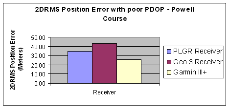
Figure 16. This chart shows position error for three receivers
when the satellite constellation was poor. The mission planning
software indicated that the maximum PDOP (Position Dilution of
Precision) at the time was about 16. The Geo 3 mask settings were
changed to allow data to be recorded.
The conclusion is that if the constellation is bad (poor PDOP),
position errors will increase and the receivers will record positions
even though the EPE (Estimated Position Error) readout has reasonable
values. Better receivers have PDOP, SNR, and Elevation Angle masks
that will reduce the probability of recording inaccurate data.
But with the better accuracy comes the "trade-off" of less efficiency.
There will be times when the receiver will have to wait as positions
won't be recorded even though it may be tracking 5 or 6 satellites
due to poor PDOP.
General comments
Some general comments about the different receivers are:
- The Garmin GPSIII+ is a very user-friendly receiver. It acquired
satellite signals quickly, and averaging a waypoint was easy
to accomplish. The factory DGPS antenna was not as sensitive
as the Trimble and was not able to receive a weak beacon signal
when the Trimble Pro XR could acquire one. There is no way to
limit the Maximum PDOP setting, the minimum SNR setting or the
minimum elevation angle.
- The Magellan Map 410 is also a user-friendly receiver. However
averaging a waypoint is tricky because averaging starts as soon
as the receiver quits moving. One is never sure if some positions
from a few feet away are included in the average. Again the
factory DGPS antenna is not as sensitive as the Pro XR.
- The Trimble Pro XR is very easy to use and it will inform
you if a beacon station is available for Real-Time DGPS. It
gives information about that beacon signal, i.e. signal strength,
frequency, bit rate, and more. Under a difficult canopy, it
seems to take time to acquire a satellite signal and a position.
This is due to the receiver mask settings, of PDOP, SNR, and
Elevation angle. It appears that the other receivers are more
sensitive and are more efficient but in reality, the data received
is not very good data and when comparing position accuracy,
the Pro XR gives better results.
- The Trimble Geo 3, with the internal antenna, does not obtain
positions as accurate as the Pro XR and sometimes the other
receivers. Using an external antenna will provide a big accuracy
improvement for this receiver.
- The PLGR is an
- older technology
- receiver, which in the open, may not be as accurate as the
newer receivers. It will acquire a signal under a dense canopy
easier that most of the C/A code receivers. It is easy to use
but requires
- Keying
- (Keying is inserting a code in the receiver to eliminate
selective availability (SA) and must be done annually). Previous
to these tests two PLGR receivers were compared on the Lubrecht
test course, one keyed with the P(Y) code and the other with
the P(Y) code
- zeroized
- (zeroized means the P(Y) code was removed and the receiver
could only receive the C/A civilian code) and the results compared.
The P(Y) code version provided smaller position errors.
Summary
In summary a good constellation is needed to get good data. If data
is recorded, it will record positions with more error. The small
handheld inexpensive receivers will provide accurate positions in
the open and under a medium canopy when good PDOP is available,
but that may not be the case under heavy canopy or when the satellite
constellation is poor (poor PDOP).
Post processing data still increases position accuracy, typically
2 - 4 meters. If data isn't needed immediately it is easier and
more efficient to collect data (ssf files) and post process the
information rather than trying to collect real-time DGPS positions.
This may change in the future when more real-time DGPS stations
come on line and all areas have double coverage (when a location
can receive a real-time DGPS signal from 2 different beacon stations).
A report written by Santiago Mancebo and Ken Chamberlain discuss
the results of the effects of SNR and PDOP on position accuracy
for these receivers and what effect they have on data acquisition
efficiency. This study was done on the Clackmas Test Course, which
has a heavy forest canopy and is similar to the Powell GPS Test
course.
Further work that should be done is:
- What is the correlation if any, between the EPE value indicated
on the GPS receiver and the real error?
- More testing of the DGPS real-time accuracy of the different
receivers and the efficiency of collecting DGPS data.
- More tests of how much post processing improves the accuracy
of DGPS real-time positions.
- The newer PLGR II, dual frequency receiver should be evaluated.
Appendix A: Summary Table
of Different GPS Receivers
|
Receiver
|
Advantages
|
Disadvantages
|
Accuracy
(Typical)
|
Approx.
Cost
|
Trimble
Pro XR
|
- Can log Data
- Can Post Process
- Can export data to Arc/Info
- Real-Time DGPS
- Accuracy
|
|
Open Canopy
1-4 m
Under Canopy
2 - 5 m
|
$10,000 |
Trimble
Geo 3
|
- Can log Data
- Can Post Process
- Can export data to Arc/Info
- Real-Time DGPS
|
- Cost
- Not as accurate as Pro XR
- Should use External antenna
|
Open Canopy
1-4 m
Under Canopy
(120 positions)
Lubrecht
2.4 - 7.7 m
Post-Processed
2.5 - 7.8 m
|
$4,500 |
Rockwell
PLGR
|
- Acquires GPS Signal in difficult canopy and terrain
better than C/A signal
- Simple to Use
|
- Must record positions manually. Doesn't log data without
external data logging device.
- Can't Post Process
- Can do Real-Time processing but then uses the C/A signal.
- Accuracy not as good as post processed other receivers.
- A military accountable item.
- Must be re-keyed annually.
|
Open
Canopy
1-4 m
Under Canopy
(120 positions)
Lubrecht
2.5 - 6 m
|
$3,500
Ext. Ant.
+$300
|
Trimble
Centurion |
- Acquires GPS Signal in difficult canopy and terrain
better than C/A signal
- Simple to Use
|
- Can use Asset surveyor software and TDC1 data logger
to collect data.
- Can't Post-Process "P" code data.
- Can do Real-Time processing but then uses the C/A
signal.
- Accuracy not as good as post processed other receivers.
- A military accountable item.
- Must be re-keyed annually.
|
Open
Canopy
1-4 m
Under Canopy
(120 positions)
Lubrecht
2.5 - 6 m
|
$4,900
Ext. Ant.
+$300
|
Garmin
III+
|
- Cost
- Ease of Use
- Readily available
- Records Waypoints and can download to their software
- Can do Real-Time DGPS with extra optional receiver
with some work
- Can Average Waypoints
|
- Can't export data into ARC/Info
- Can't Post Process
- Should use External antenna
|
Open
Canopy
1-3 m
Under Canopy
(Ave 120 positions)
2.5 - 5 m
|
$350-Unit
Soft. & Ext. Ant
+$200
DGPS
+$300
|
Magellan
400
|
- Cost
- Ease of Use
- Readily available
- Records Waypoints and can download to their software
- Can do Real-Time DGPS with extra optional receiver
with some work
- Can average waypoints
|
- Can't export data into ARC/Info
- Can't Post Process
- Should use External antenna
- Waypoint Averaging is tricky - starts when receiver
quits moving
|
Open
Canopy
2-7 m
Under Canopy
Lubrecht
(60 position average)
3 - 12.2 m
|
$350 - Unit
Software
$60+
Ant
$100
|
Table 1. Comparison of various Receivers Preliminary
only
About the Authors
Dick Karsky has a bachelor's degree in agricultural engineering
from North Dakota State University and a Masters degree in agricultural
engineering from the University of Minnesota. He worked as a project
leader in most resource areas in the USDA Forest service since coming
to the Missoula Technology and Development Center in 1977 and had
been involved in the GPS program since 1996. His current position
is Program Leader in Forest Health and in Water, Soil and Air.
Tony Jasumback, is a retired MTDC -USFS employee and was
the GPS Project Leader at MTDC, and was involved in the development
and evaluation of GPS equipment for Forest Service use since 1984.
Ken Chamberlain, is a cadastral surveyor for the USFS
at the Regional Office in Region6 at Portland OR.
Santiago Mancebo, is a Graduate student from Spain and
USFS Volunteer employee
Don Patterson is a land surveyor in the Northern Region
Engineering Office in Missoula, MT. He is a licensed land surveyor
in Wyoming and Montana. He holds a bachelor's degree in surveying
from the Oregon Institute of Technology. Don worked for the BLM
in Alaska and Wyoming before coming to the Northern Region.
Single hard copies of this document may be ordered from:
USDA Forest Service
Missoula Technology & Development Center
Building 1, Fort Missoula
Missoula, MT 59804-7294
Phone: (406) 329-3978
Fax: (406) 329-3719
E-mail: pubs_wo_mtdc@fs.fed.us
For further technical information, contact Dick Karsky at the
address above.
Phone: (406) 329-3921
Fax: (406) 329-3719
E-mail: rkarsky@fs.fed.us
The Forest Service, United States Department of
Agriculture (USDA), has developed this information for the guidance
of its employees, its contractors, and its cooperating Federal
and State agencies, and is not responsible for the interpretation
or use of this information by anyone except its own employees.
The use of trade, firm, or corporation names in this document
is for the information and convenience of the reader, and does
not constitute an endorsement by the Department of any product
or service to the exclusion of others that may be suitable. The
USDA prohibits discrimination in all its programs and activities
on the basis of race, color, national origin, gender, religion,
age, disability, political beliefs, sexual orientation, and marital
or family status. (Not all prohibited bases apply to all programs.)
Persons with disabilities who require alternative means for communication
of program information (Braille, large print, audiotape, and so
forth) should phone USDA's TARGET Center at (202) 720-2600 (voice
and TDD). To file a complaint of discrimination, write: USDA,
Director, Office of Civil Rights, Room 326-W, Whitten Building,
14th and Independence Avenue SW, Washington, DC 20250-9410, or
call (202) 720-5964 (voice or TDD). USDA is an equal opportunity
provider and
|