|
Washington
Landsat Metadata
|
For
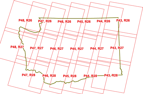
a Clickable ArcIMS version of this image with hotlinked metadata and Scene
Previews go here...
|
Washington State Remote Sensing
Consortium Landsat 2000 Metadata
|
|
Scene
|
Metadata
|
|
Path 43, Row 26
|
|
|
Path 43, Row 27
|
|
|
Path 43, Row 28
|
|
|
Path 44, Row 26
|
|
|
Path 44, Row 27
|
|
|
Path 44, Row 28
|
|
|
Path 45, Row 26
|
|
|
Path 45, Row 27
|
|
|
Path 45, Row 28
|
|
|
Path 46, Row 26
|
|
|
Path 46, Row 27
|
|
|
Path 46, Row 28
|
|
|
Path 47, Row 26
|
|
|
Path 47, Row 27
|
|
|
Path 47, Row 28
|
|
|
Path 48, Row 26
|
|
|
Path 48, Row 27
|
|
|
|
|
The Rural Technology Home Page is provided by the College of Forest
Resources. For more information, please contact the Rural
Technology Initiative, University of Washington Box 352100 Seattle,
WA 98195, (206) 543-0827. © 2000-2004, University of Washington, Rural
Technology Initiative, including all photographs and images unless otherwise
noted. To view the www.ruraltech.org privacy policy, click
here.
|