
|
Mapping Toolbox - Viewers and Utilities

 |
TatukGIS
Viewer is a free, powerful utility for quickly browsing
catalogs of GIS data and setting up customized views. It is
one of few viewers that can directly open US
Census TIGER line data without conversion to another format
first. |
| The Viewer opens ArcView and MapInfo project files
and a variety of raster (TIFF/GeoTIFF, ECW, MrSID, SPOT, JPEG,
PNG, BMP, TatukGIS PixelStore, Grid) and vector (SHP, E00, TAB,
MID/MIF, DXF, DGN, TIGER) data. The Viewer also links to vector
layers stored according to Open GIS standards in SQL databases.
The Viewer saves map projects, provides a print preview and
prints with any Windows printer. |
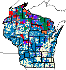 |
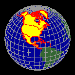
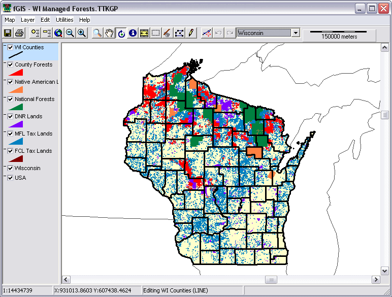
The TatukGIS Viewer offers data analysis
features to generate thematic maps based on values in GIS data
attribute tables. The example on the left (click for a larger
view) is a thematic map of managed forest land in Wisconsin.
The display colors are based on categories of public and private
ownership. The Viewer can even generate pie and bar chart map
symbols from attribute data. See the Viewer
PDF for ideas.
If you are a resource manager or educator, the TatukGIS Viewer
could help you make the most of map data by sharing it with
clients, students or others.
|
|
The Viewer includes a Wizard that automatically generates
the ASP.NET code used by the TatukGIS Internet Map Server
(see "On-line
Maps" for examples). A free trial version of TatukGIS
IS Lite map server is available for web developers. Complete
GIS applications that expand upon the Viewer can be built
royalty-free with the exceptional GIS
DK (Developer Kernel) available from Tatuk.
Click here for Digital Grove's Quick-Start
Guide for Viewer controls.
|
 |
dlgv32 Pro, distributed by the USGS,
is a limited-feature version of Global
Mapper. The viewer opens most image and vector map files.
It seamlessly integrates data layers even if projections or
scales vary. Open your first layer in |
| the desired projection, and additional layers from other projections
will be converted to align with the first "on the fly".
Users can select display, turn 3D hill shading on or off, modify
the color scheme, adjust line width and color, etc. Global Mapper
can measure areas and distances, and it generates a constant
readout of the latitude/longitude coordinates of the cursor. |
 |
ArcExplorer®
is a GIS data viewer developed by Environmental Systems Research
Institute, Inc. The free software offers an easy way to view
GIS data and perform basic GIS functions. Its interface is similar
to ArcView® software, a professional GIS program. As explained
on the ESRI site, "ArcExplorer is used for a variety of
display, query, and data retrieval applications and supports
a wide variety of standard data sources. It can be used on its
own with local data sets or as a client to Internet data and
map servers." |
| ArcExplorer comes in version 2, a standard Windows
program, or version 4 using a Java environment. If you have
access to aerial photos made with the MrSID compression format,
get version 2 since it can open MrSID images. An ArcExplorer
web
version is also available, nice if you have broadband Internet
access.
ESRI offers free
data on-line. The company also publishes books about GIS
that include tutorials and CDs with data, making ArcExplorer
an outstanding GIS educational tool.
|
 |
Any web browser can be an effective GIS
viewer. There are many map servers on the Internet that offer
fascinating geographic information, although a broadband Internet
connection is generally required. Here are a few examples to
experiment with:
The Wisconsin Department of Natural Resources offers the
ATRI
Internet Map Service. It provides basemaps useful for
planning efforts to protect aquatic and terrestrial resources.
|
Utilities for Image and Vector Data
|
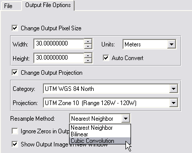
| ERDAS
ViewFinder 2.1 - The ERDAS ViewFinder is a free GIS
image viewer that can also enhance and reproject raster data,
a feature not offered by other free utilities. The program displays
ERDAS IMAGINE .IMG, TIFF (including TIFF World, GeoTIFF, compressed
and tiled variants) and Lizardtech MrSID image files, including
16-bit and floating point data types. Image manipulation tools
can overlay, smooth, sharpen, enhance, and reproject multiple
images on-the-fly.
Viewfinder's image reprojection engine supports thirty-one
categories and all their associated zones. As shown in the
following menu, you can also change the output resolution
and pixel units and choose between three resample methods.
The reprojected images can be saved in either ERDAS IMG or
GeoTiff formats.
|
 |
In order for the reprojection feature to function,
the original image must be fully georeferenced, including the
the standard pixel information found in a world coordinate file
plus the projection, spheroid and datum used. Only a few format
such as ECW and GeoTiff files contain full geo-referencing tags.
If the data you want to reproject has all the tags, the process
is a snap. If not, Digital
Grove offers a method to add all the necessary tags to an
image file needed to accomplish an image reprojection.
The procedure is somewhat complex, not recommended unless
you are comfortable with using Windows and are familiar with
GIS terms. It involves using a number of additional utilities
described here.
|
 |
ER
Mapper ECW utilities - There are four recommended ECW
programs to download: the ER Viewer, ECW Compressor, ECW Header
Editor and the ECW plug-in for ERDAS ViewFinder, all available
for free from the ER Mapper Internet site. |
| ECW stands for "Enhanced
Compressed Wavelet". It's a popular file compression
format used for GIS imagery. (MrSID from Lizardtech
is another.) ECW can reduce the size of a file twenty or more
times without perceptible loss in image quality. |
| GeoTiff
Examiner is a handy utility that can embed the contents
of a geo-referenced image's "world coordinate file"
into the header of a TIFF image file. See the description of
Zoner Draw 3 for an example
of how this utility could be used. |
Tatuk's
Aerial Imagery Corrector®, which features geo-referencing
and removal of distortion from aerial photographs, is available
as a free 30-day trial. The program's help file is an excellent
tutorial on photo rectification.
|
 |
| If you are a resource manager producing maps,
the most common approach is to create separate shapefiles for
each property or parcel you work with. A forester, for example
might use fGIS to create forest
maps for different landowners. At some point, however, it might
be desirable to have all similar shapefiles gathered together
in one layer for GIS analysis.
MapShots, a data management company for precision agriculture,
distributes a freeware utility called "JDO
Boundary Tool" that merges shapefiles. The attributes
of individual map objects are preserved by the utility, which
will only merge shapes that have identical attribute definitions.
The JDO Tool also modifies data from a John Deere office application,
a function you probably won't need, but the shapefile merge
routine is quite useful.
|
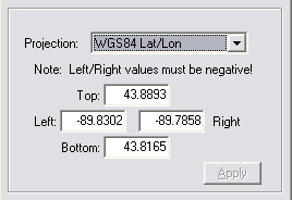 |
MapShots offers another free program
called TerraFetch
that retrieves digital aerial photos and USGS topographic maps
from TerraServerUSA® and saves the images and their associated
world coordinate files on your hard drive. Just enter the latitude
and longitude (left) of the area you want coverage for, and
TerraFetch brings them to you.
TerraFetch saves each image tile separately, so it's a good
idea to organize the tiles in folders with plain language
names so you can relocate them later. (An alternate TerraServer
downloader is USAPhotoMaps. Details are available here.)
|
 |
The Colorado
COGO program creates DXF files of precise COordinate
GeOmetry objects (such as property deeds or roads). The program
includes extensive documentation. (Other GIS programs such as
fGIS can often utilize DXF files.) |
 |
Easy
Trace is an excellent utility developed in Russia to
convert scanned maps (such as hand-drawn forestry maps) into
a shapefile vector format. The Easy Trace 7 Pro demo is fully
functional with restrictions on the size
of projects. The restrictions are not an issue for small property
maps. The Easy Trace company also offers a freeware DOS version
of the program with no restrictions, complete documentation
and an excellent tutorial. |
| DXF2XYZ
from Guthrie CAD/GIS of Australia extracts the xyz coordinates
from DXF files (a CAD vector format), handy for building data
tables for surface plotting programs like SurGe. See the SurGe
tutorial for an example.
In conjunction with DXF2XYZ, the Massachusetts
DXF Author lets create a DXF file from shapefiles.
That means you can use a program like fGIS to place place
your data points as shapefiles, which can be converted to
DXF, which in turn can be converted to XYZ text files for
data girding programs.
|
 |
Image
Analyzer from MeeSoft of Denmark is not a typical photo
program. It offers unique "deconvolution" filters
that correct blurred images (see aerial example below). In addition
to traditional picture enhancement tools, Image Analyzer features
advanced operations for examining and adjusting imagery. |
| MeeSoft also produces a simple "Diagram Designer"
that easily annotates maps and photos. Both programs are distributed
free. |
 |
Xatellite
from Shale Software in the Netherlands displays shapefiles on
a 3D globe. The shapefiles must be in the Geographic lat/lon
coordinate system, easy to find through a Google search.
TGlobe offers a freeware City
Distance Calculator that displays routes on a positional
3D globe or Mercator map. Cities are selected either by clicking
them on the globe or from a list. You can add cities if those
of interest aren't already in the extensive database.
|
| You might also want to see the Motherplanet
Earth Explorer, a rotating 3D Earth educational tool
based on 1 km resolution satellite imagery and digital elevation
models. The free demo is captivating. |
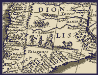 |
Commercial vendors and natural resource agencies
distribute geospatial data in compressed formats. MrSID®
format from Lizardtech, Inc. is one of the most common. (Many
historical maps like the one shown to the left are available
from the Library
of Congress and other sources in MrSID format.) MrSID
Viewer® or MrSID
GeoViewer® both produce clear images and will export
portions of images, complete with GIS world coordinates. Other
useful viewers include ER
Viewer™ for opening files with the ECW format or the
ERDAS
ViewFinder™, which opens a variety of formats. |
 |
|
|
HGIS®
GPS mapping software from StarPal, Inc. creates GIS
compatible maps and databases. It runs on Pocket PC, Windows
CE or any of the desktop Windows operating systems. The program
produces vector GIS maps and data tables on a desktop computer,
but it is designed primarily for use on a handheld PC connected
to a GPS unit.
Precision farming utilizes HGIS to measure fields and monitor
planting, treatment or harvest of crops. The possibilities
for real-time field mapping of any point, line or area features,
however, are unlimited.
The free HGIS trial and manual are excellent tools for learning
digital mapping, GIS and GPS principles. The trial is a vector
editor, opening and saving SHP and MIF files used by desktop
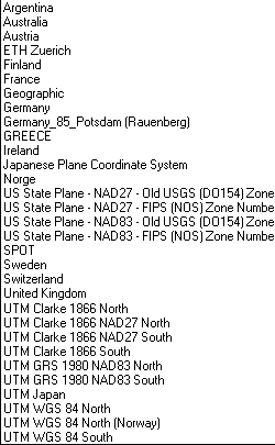
GIS programs. HGIS supports over 100 coordinate systems
and can be used to convert ESRI shapefiles from one coordinate
system to any other (for example UTM NAD27 to UTM NAD83).
The shapefile conversion feature is enabled in all versions
of HGIS, including the free demo versions.
|
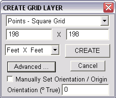 |
Another handy tool in HGIS is the ability to lay
out spatial grids. Grids can be made of cells, lines (swaths)
or points that can be uniformly or irregularly spaced (although
the free, basic, version is limited to uniformly spaced grid
points). Just select the polygon you wish to fill and then pick
the appropriate grid from the Map>Misc. Functions>New
Grid Layer menu. The grid can then be saved in any of the formats
supported by HGIS, including saving to a shapefile. (Using the
DNR Garmin Tool, you could then send the grid shapefile as a
series of points or a track to your GPS unit for navigation
in the field. If you have the full version of HGIS, you could
use such a grid directly on a GPS enabled PDA to map your data
points.) |
| Note to ArcView 3.2 Users: If you are looking
for an excellent extension that lays out either a uniform
or random grid or cell network inside a polygon, see the
Minnesota
DNR Sample Generator Extension. |
|
| HGIS incorporates an application builder that
makes templates complete with drop-down pick lists for easy
data entry of map objects measured or described in the field.
The free trial does not load raster images for base maps. It
is time limited only when a GPS unit is attached and activated.
StarPal also offers a version of HGIS with raster image,
geo-referencing and vector editing functions.
|
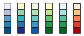 |
Need help selecting a color scheme for a map?
Try the on-line Color
Brewer from Penn State's Geography Professor Cynthia
Brewer. The application explains the merits of sequential, diverging
and qualitative legend types. You can select from a variety
pre-formulated color schemes and then see them applied on a
sample map. You can then save the color values for use in mapping
or illustration programs. |
 |
Convert
is a freeware program that translates distance, areas and other
units ? very useful for changing between metric and imperial
measurements. (Convert is included in the fGIS
distribution file.) |
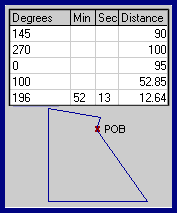 |
MapDraw™
creates property boundaries from metes and bounds descriptions
found in deeds. It's a lot easier than pulling out a protractor,
ruler and calculator to draw out a tract. The program handles
curves, automatic closures, acreage and perimeter calculations,
print scaling, multiple lots, imperial or metric measurements,
etc. MapDraw 2.7, only 147KB zipped, is shareware providing
both azimuth (360°) and bearing versions. The program will
save a BMP image of the plot, but it is not georeferenced. See
the Colorado COGO program for that.
Informatik,
Inc. also offers a newer time-limited trial, now called
Mapdraw Deed Mapper 7.5.
|
| Windows Explorer can be frustrating when you want to change
file extensions or make file property changes to batches of
files or whole folders. PropertiesPlus™
solves the problem. After installation, access it by right-clicking
a file (or group of files) in Windows Explorer and picking PropertiesPlus
from the drop-down list that appears. The PropertiesPlus dialog
box opens, where changes are easy to make. |
 |
UltimateZip™
is a freeware archive utility that can easily decompress TAR,
ZIP and GZIP format files that are often used for geographic
data. |
 |
A good screen capture program is often valuable
in mapping projects. Gadwin
Print Screen™ works well, with a simple interface
and small memory usage. |
|
|


