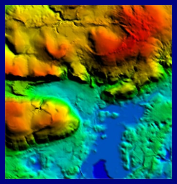
This image shows a portion of a 30-meter resolution Digital Elevation Model (DEM), downloaded from GeoCommunity. The DEM was opened in Global Mapper. It produces a 3D view from a vertical perspective when hill shading is turned on:
|
|
|
This image shows a portion of a 30-meter resolution Digital Elevation Model (DEM), downloaded from GeoCommunity. The DEM was opened in Global Mapper. It produces a 3D view from a vertical perspective when hill shading is turned on:
|